Here's something you might be interested in.
Ask a Hipster — Advice you didn't know you needed
Big Screen — Movie commentary
Blurt — Music's inside track
Booze News — San Diego spirits
Classical Music — Immortal beauty
Classifieds — Free and easy
Cover Stories — Front-page features
Drinks All Around — Bartenders' drink recipes
Excerpts — Literary and spiritual excerpts
Feast! — Food & drink reviews
Feature Stories — Local news & stories
Fishing Report — What’s getting hooked from ship and shore
From the Archives — Spotlight on the past
Golden Dreams — Talk of the town
The Gonzo Report — Making the musical scene, or at least reporting from it
Letters — Our inbox
Movies@Home — Local movie buffs share favorites
Movie Reviews — Our critics' picks and pans
Musician Interviews — Up close with local artists
Neighborhood News from Stringers — Hyperlocal news
News Ticker — News & politics
Obermeyer — San Diego politics illustrated
Outdoors — Weekly changes in flora and fauna
Overheard in San Diego — Eavesdropping illustrated
Poetry — The old and the new
Reader Travel — Travel section built by travelers
Reading — The hunt for intellectuals
Roam-O-Rama — SoCal's best hiking/biking trails
San Diego Beer — Inside San Diego suds
SD on the QT — Almost factual news
Sheep and Goats — Places of worship
Special Issues — The best of
Street Style — San Diego streets have style
Surf Diego — Real stories from those braving the waves
Theater — On stage in San Diego this week
Tin Fork — Silver spoon alternative
Under the Radar — Matt Potter's undercover work
Unforgettable — Long-ago San Diego
Unreal Estate — San Diego's priciest pads
Your Week — Daily event picks
Does the San Diego River still have life in it?
Our 52-mile-long ribbon of life is mostly run-off
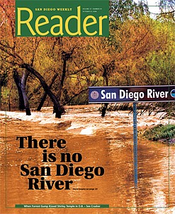
San Diego River? “There is no San Diego River,” says Pete Cuthbert. “What you’re dangling your toes in is the Colorado River, the Sacramento River, the Feather River — but not the San Diego River.”
“Not the San Diego River…?”
“No. This San Diego river water is basically runoff from the lawns and cisterns and radiators and factories and gas stations of San Diego, via polluted tributaries like Forester Creek in El Cajon. And we get most of that water from Northern California. Without runoff there would be no river, period. Not at this time of year.”
Pete and I are sitting at an idyllic pond above the Old Mission Dam. It’s a June morning. The day is just warming up. Around us the trees and scrub grow wild and messy, pretty much as they did in Kumeyaay times, I’m guessing. Ten yards to our left, a blue heron stands statue-still on a spit of sand, looking for fish movement. Wouldn’t mind tossing in a line myself. This fresh morning, you feel a bit like Huck Finn heading out for an adventure up the river.
And, actually, that’s what we’re having. We’re setting out to see if this 52-mile-long ribbon of life still has life in it. Or if it has been dammed and developed and poisoned to death by us — the three million people who’ve come here to a semi-desert and expect water whenever we turn the taps on.
Because, come on: mentality-wise, San Diego is a beach town, right? Not a river town. We’re not talking Paris and the Seine (accordions, please), London and the Thames, Baghdad and the Euphrates, Cairo and the Nile. Why worry about this little local “upside-down river,” as the Kumeyaay called it in summer when the water disappeared and flowed underground? We have water from the north. The mighty Colorado is just a couple of hundred miles east. This local river has no spectacular rapids. It’s no Moon River, “wider than a mile.” It’s just something that floods Fashion Valley every winter, a wasteland where you toss your old mattress when nobody’s looking. Yard fences back onto it. Heck, it only gives us five percent of the water we need. It takes up valuable shopping space in beautiful Mission Valley, and it could be piped or sluiced through unseen concrete pipes to get out to sea. Especially if Pete’s right — that it’s kind of like the Salton Sea, just a collection point for pesticide/fertilizer/oil-laden runoff that you wouldn’t push your mother-in-law into. After all, L.A.’s done it, TJ’s done it: laid a concrete bed, got rid of the messy riverbank ecology with its bushes where homeless hide out and West Nile virus mosquitoes breed, and just turned it into a pragmatic ditch. Why should you have to deal with the gritty water, the flooding, the bridges…
Guess the problem with that is, well, think Twain: Huck Finn. Think Grahame: The Wind in the Willows; or Renoir: Luncheon of the Boating Party; or Andy Williams crooning “Moon River”… River culture is so damned seductive. The feeling that life is born here. This moment. Sitting by a pool of brownish but clear water, tossing Pooh sticks to see which will drift to the little waterfall first (you have read your Winnie the Pooh — A.A. Milne’s House at Pooh Corner — haven’t you?), as if we were kids, dragonflies darting, unknown birds squeaking — least Bell’s vireos? — unseen in the trees, and the rustle of…snakes? No. Cheeky lizards. This is the other Diego. In the culture of beach, desert, and freeways, this green, cool, slow, secret world has been left out of the picture.
But now I’m in it, it’s growing on me.
It’s an eerie feeling, here among the trees, contemplating the river. Europeans have been here, what? Two hundred years. The Kumeyaay, 2000 years. The river, 2,000,000 years. This is not “our” river. We’re temporary shapers of its way. But it will have its way in the end.
Which is what Mr. Cuthbert is trying to show me too. He has been fighting to save San Diego’s modest river (its watershed — the area it draws its real waters from — is 400 square miles — compare that with the Tijuana River’s 1700 square miles) for half a century. He has walked most of its length. He’s compiling a book on the “Native Plants of the San Diego River Basin.” The man’s a walking watercourse encyclopedia. He wants to show me why this is worth saving from its abusers, from gravel-pit diggers, garbage dumpers, recklessly near-the-bank condo developers, levee builders, from a general attitude of disrespect and neglect. Twenty-five years ago, Cuthbert was the City’s park planner and project manager for a comprehensive “Preliminary Master Plan” for what was then called the “San Diego River Project.” The plan took years to work up. It went into all the problems and ended up, of course, on a dusty shelf. Cuthbert has what is probably the sole remaining copy.
Today, he’s going to show me what went into that report.
The River’s Upside-Down Today
“This is what I wanted to show you first,” Pete says. We’re at the Old 1815 Mission Dam, the earliest-known big dam in San Diego. “It was the first irrigation/flood-control project on the Pacific Coast,” Pete says. This was the place where the padres and the Kumeyaay worked together to provide the Mission with water. So the padres could plant their corn and raise their cattle, using the converted Indians as convenient labor, of course. Working in the fields for the Lord. Their work, our Lord.
But the dam certainly did get the Mission and the Spanish colonists going agriculturally.
I’m looking at this great, thick, brick and rock and cement wall that stands over 10 feet high, 10 feet thick, and runs about 245 feet across the river, like a Roman bridge. The water spills through a 12-foot center section where you can see slots for planks to complete the damming process. We’re about six miles upriver from the San Diego Mission. The padres needed constant water for their fields and for themselves, and, then as now, the San Diego River was a stop-start affair. Either flood or drought, it seemed. So in 1813, 195 years ago, right on this spot, which is now part of the City’s underappreciated Mission Trails Regional Park, their Kumeyaay converts recommended a place for a dam with a flume to run the water down to the Mission. They used kilns here to make a mortar of lime and seashells to cement rocks together, a method brought directly from Rome. Then they built the six-mile cobblestone flume lined with ceramic tile (also shaped and baked here), placed like upside-down roof tiles.
It was one of those miracles that made the padres realize they could stay and make a go of it here after all. The water backing up behind the dam formed Kumeyaay (formerly Collins) Lake, 300 yards of potable (at least then), fishable, irrigation-capable water. In the years following, during the early 19th Century, the padres were said to have accumulated 20,000 sheep, 10,000 cattle, and 1,200 horses on their lands. All because back in 1774, they had elbowed aside the Kumeyaay village of Nipaguay and moved their Mission from Old Town’s Presidio up to near today’s Qualcomm Stadium. It proved a good site: Above the waters (the 1916 superflood came up to the fifth step of the Mission’s front staircase), yet accessible to fresh water, thanks to the flume.
Pete and I walk through flat areas that he says were occupied, back in 1774, by a Kumeyaay village. We look for some of the tiles that lined the flume. We find evidence of sleeping circles, circles of stone where Kumeyaay men, or women, slept. “Watch for those gopher holes,” Pete says. “Snakes often use them.” He hadn’t wanted to do this earlier in the day because rattlesnakes and their young often emerge from dens early to warm up. By now, they’re seeking shade under rocks. But we come around one bend to see a red-and-cream snake, maybe five feet long, sunning itself on the gravel road. It sees us and sidewinds off into the bushes. “Red racer,” says Pete. “Not poisonous. But when I was climbing this riverbed on my own, I brought a snake kit with me, just in case I surprised a rattler.”
What strikes me, as we drive up through Mission Trails Park, is how healthy and pristine the river looks. “Appearances can be deceiving,” Pete says. “The only reason fish survive in many of these patches of river is that the fertilizers from lawns promote plant growth, and even though that strangles the river, it provides oxygen for the fish to breathe in what would otherwise be dead water.” He drives me past admirable floodplain parks such as El Monte, a green, treed oasis among piles of sand and gravel, then onto a dirt road and through a valley busy with horse ranchettes. We’re headed for El Capitan, the dam that stops the San Diego River, and its fish, in their tracks. Finally, we turn right to cross the river — and drive over dry dirt.
“That was the river?” I ask.
“That was the river. Underground today.”
I think of the old Kumeyaay phrase, “upside-down river.” This is what they were talking about.
Rivers Need to Have a Life
And yet, farther up, near the river’s exit from El Capitan Reservoir, here it is gurgling again. We stop beside a gang of orange-jumpsuited female prisoners hauling beds and mattresses and lamps and garbage up from the side of the river and onto a truck’s flatbed.
“Would you drink this river water here?” I ask Pete.
He shakes his head.
“Look, the health of the river is directly proportional to the amount of water that flows down it,” he says. “Today, what we have in the San Diego River below this dam is largely what it gets from Forester Creek, which drains the El Cajon Valley, meaning runoff from people watering their front yards, draining their radiators, cleaning their roof gutters, and so on. The quality of Forester Creek is not good at all. And then we have other little creeks that come into the San Diego River, and they all contribute to its unhealthy state. And the groundwater is very poor quality. San Diego still has wells in Santee; they have wells in the Grantville area, but they don’t use them. The quality is bad. Very bad. It’s definitely polluted. If we have a good rainy season, that helps reduce the salinity in the underground water. It also helps clean up the rivers. But I would say today that the river’s not very healthy. There are a few reasons why: the bulrushes, the Arundo donax, cattails, nonnatives. The river can’t sluice them out. The dams are holding back the normal flow of water. You’d probably have a year-round flow if it wasn’t for the dams. The dams help our water supply. We’re taking more than half of the river’s water above El Capitan and San Vicente dams. But that’s only five to ten percent of the water San Diego needs.”
With dams, he says, natural processes grind to a halt. The fish can’t swim up to spawn, the floodwaters are held back so the river can’t clean itself out, then when there’s a really big flood, the dams spill, and it becomes very damaging.
“Rivers need to have a life,” he says.
And people get a false sense of security downstream. The sand and gravel companies dig big holes, which change the dynamics and temperature of the river flow. Developers build nearer to the river bottom (land right next to the bank). Cities build levees to stop flood waters spreading out. Result? Water, river denizens, and good fertile silt race out to sea.
So what happened to Cuthbert’s grand 1983 plan for the river…
…which he and the consulting company, Wirth Associates, submitted to the county?
“I prepared [a report] for the approval of the Board of Supervisors,” Cuthbert says. “We were going to hire a consultant to come up with a plan. A $300,000 plan. What to do with the river, recreationally and [financially, etc]. It was going to be a river-park plan. So then I came up with a large plan that I presented to the Board of Supervisors.”
Cuthbert and the consultants advocated habitat restoration and the transformation of much river bottomland into parks, aiming for riverside walkways “from the ocean to the mountains.”
“I garnered the best talent I could find,” he says. “And we had a pretty good relationship with the Bureau of Land Management and other agencies, because they’re already acquainted with the project. It can be a juggling act, especially with 300 property owners, some of whom were irate. We had to convince them that we were not trying to take their property away, and in reality, we’re probably going to help improve their property values. I also tried to get funding for lower Mission Valley, and state funding, but it lost by one vote of a particular committee.”
Maybe that was because the writing was already on the wall: Intensive commercial development for Mission Valley had long since trumped the river’s health and flooding concerns. When the city allowed the Town and Country Hotel to come in, they knew they were opening a Pandora’s box.
“[By 1983] Mission Valley was the geographic center of metropolitan San Diego,” Pete says. “Development came in faster than they expected, and that’s been sort of typical of the City of San Diego. They are always having to react, rather than plan ahead. They say, ‘Oh, gee, we have this developer who’s coming in with this beautiful project. What should we do?’ In most cases they say, ‘Okay. We’ll give them the rubber stamp’ because they don’t have any advance planning to know whether that project is a good project or not. That has historically been a problem for the City of San Diego, in the Planning Department.”
Since 1983, he says, not much has happened. “There was a little activity in the Lakeside area. People there borrowed my reports and exerted a little bit of pressure. They have done some work in developing park space. Santee has done some work, but nothing extensive, utilizing river bottomland. As far as I know, [since] this plan died on the shelf, there have been no efforts to acquire land or set aside land or zone it for open space or anything like that. In the lower San Diego River, they have. But not in the upper San Diego River. [In the lower San Diego River area] they have the City of San Diego behind them. Its planning department is [aiming] for walkways, some greenbelts, green space, but it’s virtually minimal. Adjacent property owners do not want to give up that land. I mean, it’s worth hundreds of thousands of dollars an acre. And so they look at it from that pragmatic point of view. They don’t look at it from the aesthetics at all.
“For instance, there are big-mouth bass there, bluegills. They live for the floods, so to speak, and they take advantage of the ponds around there. There are portions of the San Diego River, like around Grantville, that are fairly deep, and they hunker down and wait for the rains to come. But that would be the only area that would have any fish, the Grantville area.”
How do we rate against other river towns?
Cuthbert says most towns just want to squeeze their rivers down as tight as they can. “You’ve got Los Angeles: all concrete channels. Phoenix, Arizona, has tried to change. They have a pretty good river/flood-control project. Phoenix is the most forbidding area to try to have a park, in a river bottom. But they have worked at it. And San Antonio, Sacramento, and Seattle have some river projects, restoring the natural ecology and making them available for the public. San Diego is very far behind all these people. The property owners here control the situation, unfortunately. The gravel and sand people were the ones, initially. Over the past 30 years, they did not want any parks or anything. They’re also the ones who were dumping construction spoil in the barrow pits where they had mined the sand and gravel. And they’re probably getting paid to allow [people] to dump in these barrow pits. So they become little ponds. Well, to utilize that land, the sand and gravel companies would rather have these ponds in-filled and covered over because eventually, maybe 20, 30, 40 years from now, they can build on them. So they have their own priority. And it’s not recreation, and it’s not aesthetics.”
Restricting Humans So the River Can Have Life
It’s morning in La Jolla. Here at UCSD’s Thurgood Marshall College, Jim Bell holds forth to undergrads, mostly engineering students. He has a PowerPoint presentation on the blackboard screen. It shows an artist’s rendering of a verdant valley, seen from above. A river winds down among woodland and meadow, with some fields cultivated, and some houses — but only peeking down from the valley rim.
“When I ran for mayor of San Diego in 2004, against Murphy and Roberts and Peter Q. Davis,” says Bell, a big, fervent, self-styled eco-designer from O.B., “the final debate was on Channel 10. It turned out I was the last one to speak, and I’d written this little poem: ‘These guys are the old, I’m the new, I’ve got a plan, They haven’t a clue.’ ”
He looks up at the painting. “This,” he says, “is Mission Valley [as it could be in], say, 2060. It has the best soil. It has a river that needs its 100-year floodplain. You can either constrict the river or restrict humans. That’s what we’re doing here. Restricting humans so the river can have life. Remember, every year, pretty much, Mission Valley floods in winter. The chronic and the catastrophic costs add up. It’s common sense.”
He goes on to explain the logic behind depopulating and “re-naturing” the San Diego River’s 100-year floodplain. “If you add all the tax revenue being generated by the properties down there [in Mission Valley], that’s the income. And then you say, ‘Well, what are the chronic costs every year? What are the 10-year flood-frequency costs? What are the 25-year frequency costs? Hundred-year flood costs?’ We can’t prove it yet because we haven’t done the work, but I think it would turn out that it would be a net loss.
“And it’s like the developers would get in, and they make money, and then they’re out of it. And then when the disaster happens, it’s the public who’ll be on the hook.
“So, let’s say I’m elected mayor: I put forward an ordinance to prohibit any further development in the historic 100-year floodplain. People can still be there, but they won’t be able to add on to whatever they have. They can repair, but eventually buildings wear out and aren’t worthy of repairing anymore. So then you take them out of there [or] move them someplace else. And, of course, as soon as you pass a law that says you can’t develop the floodplain, it’s going to make the land in the floodplain less valuable. So people could legitimately scream, ‘Hey! What are you doing? You’re changing the rules.’ Assuming they were playing by an old set of rules, and playing correctly, they shouldn’t be penalized. So the way you work it is that the land in the floodplains goes down in value — but what’s going to happen to the land just outside the floodplain? That’s going to go up in value. Because eventually you’re going to be overlooking this beautiful park area, agrarian, horseback riding, tourists coming from all over the world… And so what happens is, somebody who already owns land outside of the floodplain (in that same local area) decides to sell their land. And let’s say that before you prohibited floodplain development, the land was worth a million dollars. OK, after you prohibit it, [that land] is worth $2 million. But that second million is unearned. Because they didn’t do any improvement. So you let them have 20 percent of that. They get the million, they get 20 percent more, then you use the other $800,000 that’s left to compensate the people whose land got devalued. So everybody gets out whole. No taxes [have been] involved.”
What Jim Bell’s worried about, he says, is the Big Flood coming. Like the one that happened in January 1916, when 70,200 cubic feet of river water per second gushed through Mission Valley, when it flooded wall-to-wall up to the fifth step of the San Diego Mission.
Yes, he says, it might take at least 60 years to give the river its floodplain back. “I mean, you’d say, ‘We’d like to do it as soon as we can because otherwise we’re just keeping our fingers crossed that the big flood doesn’t happen in the meantime.’ But the more we’ve done when the big flood comes, the less we’re going to lose, the less the damage is going to cost.
“We in San Diego [city] have done a particularly egregious job, building [recklessly] in the floodplain. But many cities build in floodplains. Look no further than Del Mar. Its racetrack is squarely on the San Dieguito floodplain. There you [might] say, ‘Well, maybe that’s not so bad, because you run over a racetrack with a flood, big deal. You can push the broken buildings into the ocean.’
“But also, here’s the thing. Floodplains are fertile. How crazy is it to pave over your most fertile land? Especially as ‘think global, act local’ will become more and more necessary. Look at the rising cost of transporting, say, lettuces 1500 miles. We’re going to need our fertile land. But there are lots of things you can do in the floodplain, like grow food and make [tourist] money, [things] that are not going to be damaged very much if there is a big flood. Some Mississippi towns have already backed up beyond their floodplains. It’s just common sense.”
Bell has an interesting résumé. He has written two books on living harmoniously with Mother Earth (Achieving Eco-Nomic Security on Spaceship Earth and Creating a Sustainable Economy and Future on Our Planet) and worked for César Chávez during his Farm Workers’ Union organizing days. “If a flood happened when El Capitan and San Vicente dams were full or broken, you could expect, where 163 crosses the river, to have water 30 feet deep. It could go as high as 100 feet. The last so-called 100-year flood was 1916. And now, with global warming, there are fears the hurricane track will edge north toward San Diego.”
“We Decided to Give the River a Voice”
Bell isn’t alone on this. There are at least 68 related groups working to save the San Diego River. Rob Hutsel tries to coordinate their efforts. More than that, he’s been prepared to get down and do the nitty-gritty things like pick up trash along the riverbank — in a different league from spotting for least Bell’s vireos here and elsewhere. And his group is actually making significant progress in a part of the river just east of the 5, across from Old Town.
I got off the green line trolley at Morena Linda Vista after a beautiful scenic ride crisscrossing the river from San Diego State. You walk across Friars Road, run down a gravel embankment where a wooden sign says “Mission Valley Preserve,” and suddenly you’re in a different zone. It’s like putting on a pair of those Bose noise-dampening earphones. You’re hearing birdsong, kids laughing. A group of YMCA children is sitting on a wooden bench in a clearing in the bushes, hearing about how to use native plants for medicine and food. Hutsel’s here, looking the dapper guy he is (he used to work in Mayor Susan Golding’s office and says she called him her “Officer of Common Sense”), as the director of the San Diego River Park Foundation. He starts giving me the spiel, which is fine because I know nothing about this place. Never noticed it before. “It’s the only City park in all of Mission Valley,” he says. “Fifty-two acres. Bounded by 5, 8, and the river runs through it. It’s a good study for what we’re trying to do.” He’s leading me along a track as he speaks. He stops at a bush with clusters of cream-colored flowers with little racks of blue berries. He picks a few off. “Try some,” he says.
I do, and they taste like…blueberries. “Blue elderberry,” he says. “Native. Birds love them too.”
He says he came to this kind of work after the massive (34-million-gallon) sewage spill up around SDSU, Adobe Falls, that happened back in 2000. Of course, the sewage ended up in the river. “It ran for a week,” he says. “Nobody cared. There was no public outcry. A dozen of us got together at Donna and Skip Frye’s surf shop and decided to get organized. We decided to give the river a voice. We needed to create an umbrella nonprofit.”
But the Mission Valley Preserve actually started off as a police project.
“The Western Division station is right across Friars Road. And they were dealing with a whole lot of petty crimes, vandalism, misdemeanors. They got together with councilmember Valerie Stallings. I was working for the mayor. I’d come down and volunteer in a cleanup, and then we had the idea to dedicate it as parkland. Police brought their Homeless Outreach Team, their HOT team, and they did a survey. It was amazing. They found that there were over 100 people living down here in this river area. One person had been living here for longer than 12 years. And you’d go down, and there were literally piles of trash 20–30 feet across, solid paper, human waste, clothes. But they had kitchens set up, car batteries that were probably stolen — that’s how the police got involved. But they had incredible places. Sometimes the ‘homes’ were two stories high. They had a mayor; and the community was purposely divided: on one side of the river — the north side — were the people who did drugs; on the other — the south — were the people who didn’t. So the River Foundation was born a little after that survey, and one of the big health impacts was the homeless population. All of that trash. And people were living in the river, bathing in the river, defecating in the river… Imagine 100 people doing that: it doesn’t sound like a lot, but it is. And the one thing that got us going was the fires. There used to be a fire a week down here. Some of the wires were being stolen from the neighborhood [from businesses and homes], and then they’d come down here and melt off the insulation, and then they’d sell the copper. There were hundreds of needles. So we made a decision that we were going to try to make a difference. I personally made a decision that it wasn’t okay to leave the status quo here. It wasn’t good for the people living here, it wasn’t good for the wildlife. So, and slowly and methodically…now, the fruits of our labor are such that all that trash is gone. We’ve removed it all, over 800,000 pounds of trash. That’s just our side. The city’s removed a whole bunch as well. And we tried to find alternative places for the people to live. But our latest survey shows nine camps with one or two people in each. So that’s way down.”
As we talk, we walk. We’re going down a path that heads underneath the low trolley bridge and then into taller trees. “But dealing with homeless problems is not my job,” Hutsel says. “My job is to make the river healthy, and that I will do. The great news is that in the last year to two years, we’ve seen two endangered bird species, including least Bell’s vireo, come back. They winter down in Baja, and this year we’ve heard two pairs. Which is incredible. There’s something like 1000 left in the world, and the San Diego River is one of the places they come to. The other we’ve spotted is the Southwestern willow flycatcher. And we have lots of willows. Though when we started out it was wasteland. We’ve also seen bobcats in here. The fact that they’re here means that it’s an inviting-enough place for them. We’ve seen the tracks and the bobcats themselves.”
We pass a kiosk shade-structure that kids from High Tech High designed and built. “We call this ‘the gathering place,’ ” Hutsel says. “We’ll be having the trolley dancers here this year. Who would have thought of that?”
We carry on through the trees, looking at areas Hutsel’s teams of volunteers have cleared, nonnative trees, like palms, that they have rooted out, and pipes that deliver trash-loaded runoff water from gutters as far away as USD up the hill. “So if you’re up on Linda Vista Road,” Hutsel says, “and you throw your cup out, this is where it comes out, and we have to pick it up.”
We follow tracks down to the water — yes, past one blue tent hiding in the reeds. It almost seems like a vernal pool, deep, still, with bubbles that make you think there might be fish down below. I spot a little island farther out, the perfect Peter Pan pirate hideout. By the time we’re through, I’m sold. These guys’ efforts are going to be worth it. It’s as if they have dug up a beautiful, invaluable, forgotten ancient treasure, even though, so far, they’ve just cleaned off the first layer.
“What we really want is a 52-mile-long river park,” says Hutsel, “from ocean to mountain source. We’re planning an October ‘River Blitz’ to document the whole length. Plus, we’ve established a river garden. Planted 1300 plantings, like sycamore trees and a lot of flowering native plants. The idea is to take over this space and make it attractive.”
And, yes, he says, they have perch, bass, catfish, and mullet near the coast that are surviving quite well. Fish often like the winter better because it’s cooler, and more water tumbles more vigorously, capturing more oxygen.
Still, there are forces out there to deal with, like the trolley people, who pushed through their trolley line — which travels back and forth across the floodplain — without real consultation. “They effectively stopped the continuity of the trails because the bridge supports are too low in places,” Hutsel says.
Standing here, with the willows, and the water, and an egret in the water yonder, I suddenly think of Renoir’s famous river painting, Luncheon of the Boating Party.
“Any chance of river cafés strutting out over the river?” I ask.
“Oh, sure. We’re thinking about that,” Hutsel says. “In fact, we’re planning a 17-acre Discovery Center, near Qualcomm Way, which would include cafés and educational programs. We have the conceptual drawings already.”
I leave Rob back at the gathering place and then head into the bushes to see if I can locate the guy living in the blue tent. Instead, I’m hardly into the trees when I spot this guy and a lady, walking toward me and heading for the road. He calls out, “Help you with something? Looking for somebody?”
Pretty soon we’re talking away. Tom. He was a Marine in Vietnam. Medic. Had some ba-ad experiences. Relives them every night. Prefers the open air, where he doesn’t feel trapped. “Drugs? No. That’s not it, man. It’s…freedom. That’s what it is. Me and my lady here. We’ve got all the shops we want nearby. There are 47 of us living out here in this part of the river. It’s just the right amount. Forty-eight, and we’d have fights. You know when the tipping point comes, and somebody’s got to move on down the river.”
His lady says she wouldn’t have it any other way. “Sometimes people from the outside see me, a chick, especially, and they’ll come up and it’s ‘Let me tell you about these programs. Here’s a list of shelters, places you can stay.’ And I don’t want that. That’s like jail to me. You’ve got to live by somebody else’s rules.”
“I’ve lived down here for years,” says Tom. “But I tried the other. I went out and rented a place in Spring Valley, $2100 a month. Beautiful view, nice house, central heating, everything — it was driving me nuts! I went and got everything I was supposed to have, swimming pool, Jacuzzi, beautiful house, nice neighborhood. But I was starting to get claustrophobic. And you know what? The best part about camping out is when you’re settled in, and it’s all nice and warm-snuggle, and the rain’s hitting your tent, or the sun’s rising…that’s what it’s like out here. I’m a carpenter, I worked down in NASSCO for years. I was a paramedic too. If somebody gets hurt down here, they come to me. I’ve set shoulders. Couple of weeks ago, a guy had a heart attack. I ran over and got that guy going…and you know, that’s what it’s like out here. We’re family.”
Would I be able to spot his place from the bridge? “No way, man! Vietnam. Camouflage. You never give them a reason to come after you. Plus, I’ve got a couple of herons I rescued as young babies. A blue and a white. They’re my guard dogs now, and they can see from above. Nobody finds my island without my knowing. This is my river, man.” He puts his arm around his lady. “Our river.”
Jim Pugh and I stand stock still. Pugh is one of San Diego’s most respected environmental advocates. We’re transfixed by a giant bird standing in the reeds. A breeze ruffles the waters. “He’s spotted something,” Pugh whispers. “He’s waiting…whoa!”
The heron stabs the water, keeps his head under for the longest time, then comes up with what looks like an eight-inch squiggling fish, which he flips back and forth until it points throatwards. Then you see it travel, struggling, on its last voyage, down the long, thin gullet. Who knew? Right here in deepest Midway, near the Sports Arena, at the end of the river’s 52-mile journey to the sea.
It’s a slough, the Famosa Slough, an inlet where the tidal waters of the San Diego River and the Pacific Ocean mix, and where wildlife unexpectedly thrives. “It’s incredibly healthy,” Pugh says. “And not by chance.” For sure. The battles over the Famosa Slough are, well, famous. People have been fighting over this little nursing ground for fish, plants, and birds since the ’30s, but especially since the 1970s, when development threatened to fill it in. The city bought the 37-acre waterway to preserve it in the early ’90s, but it has been local neighbors like Pugh — who have fought unremittingly to keep people back, give the wildlife breathing room, filter the polluted waters of the river channel, plant native plants, and fight invasive exotics — who have made it the life-sustaining miracle that it is. “Today, we have 180 species of birds, 8 species of fish, and countless crabs that use this slough,” Pugh says. “It’s an important Pacific Flyway stop and vital for ‘vagrants,’ birds that decide to settle and live here. Even though it’s a shadow of what it was, when the whole of Mission Bay Park was a slough, it’s something.” He also knows it’s just one small body part of a giant living organism called the San Diego River, whose larger recovery is not going nearly so well. But he and the rest of the silent army up and down the river, people who love it, from Hutsel to Cuthbert to Jim Bell to Tom, aren’t about to give up. “Our motto is ‘Every loss is permanent,’ ” Pugh says, “ ‘and every victory is temporary.’ ”
Here's something you might be interested in.
Does the San Diego River still have life in it?
Our 52-mile-long ribbon of life is mostly run-off
Does the San Diego River still have life in it?
Our 52-mile-long ribbon of life is mostly run-off
San Diego River? “There is no San Diego River,” says Pete Cuthbert. “What you’re dangling your toes in is the Colorado River, the Sacramento River, the Feather River — but not the San Diego River.”
“Not the San Diego River…?”
“No. This San Diego river water is basically runoff from the lawns and cisterns and radiators and factories and gas stations of San Diego, via polluted tributaries like Forester Creek in El Cajon. And we get most of that water from Northern California. Without runoff there would be no river, period. Not at this time of year.”
Pete and I are sitting at an idyllic pond above the Old Mission Dam. It’s a June morning. The day is just warming up. Around us the trees and scrub grow wild and messy, pretty much as they did in Kumeyaay times, I’m guessing. Ten yards to our left, a blue heron stands statue-still on a spit of sand, looking for fish movement. Wouldn’t mind tossing in a line myself. This fresh morning, you feel a bit like Huck Finn heading out for an adventure up the river.
And, actually, that’s what we’re having. We’re setting out to see if this 52-mile-long ribbon of life still has life in it. Or if it has been dammed and developed and poisoned to death by us — the three million people who’ve come here to a semi-desert and expect water whenever we turn the taps on.
Because, come on: mentality-wise, San Diego is a beach town, right? Not a river town. We’re not talking Paris and the Seine (accordions, please), London and the Thames, Baghdad and the Euphrates, Cairo and the Nile. Why worry about this little local “upside-down river,” as the Kumeyaay called it in summer when the water disappeared and flowed underground? We have water from the north. The mighty Colorado is just a couple of hundred miles east. This local river has no spectacular rapids. It’s no Moon River, “wider than a mile.” It’s just something that floods Fashion Valley every winter, a wasteland where you toss your old mattress when nobody’s looking. Yard fences back onto it. Heck, it only gives us five percent of the water we need. It takes up valuable shopping space in beautiful Mission Valley, and it could be piped or sluiced through unseen concrete pipes to get out to sea. Especially if Pete’s right — that it’s kind of like the Salton Sea, just a collection point for pesticide/fertilizer/oil-laden runoff that you wouldn’t push your mother-in-law into. After all, L.A.’s done it, TJ’s done it: laid a concrete bed, got rid of the messy riverbank ecology with its bushes where homeless hide out and West Nile virus mosquitoes breed, and just turned it into a pragmatic ditch. Why should you have to deal with the gritty water, the flooding, the bridges…
Guess the problem with that is, well, think Twain: Huck Finn. Think Grahame: The Wind in the Willows; or Renoir: Luncheon of the Boating Party; or Andy Williams crooning “Moon River”… River culture is so damned seductive. The feeling that life is born here. This moment. Sitting by a pool of brownish but clear water, tossing Pooh sticks to see which will drift to the little waterfall first (you have read your Winnie the Pooh — A.A. Milne’s House at Pooh Corner — haven’t you?), as if we were kids, dragonflies darting, unknown birds squeaking — least Bell’s vireos? — unseen in the trees, and the rustle of…snakes? No. Cheeky lizards. This is the other Diego. In the culture of beach, desert, and freeways, this green, cool, slow, secret world has been left out of the picture.
But now I’m in it, it’s growing on me.
It’s an eerie feeling, here among the trees, contemplating the river. Europeans have been here, what? Two hundred years. The Kumeyaay, 2000 years. The river, 2,000,000 years. This is not “our” river. We’re temporary shapers of its way. But it will have its way in the end.
Which is what Mr. Cuthbert is trying to show me too. He has been fighting to save San Diego’s modest river (its watershed — the area it draws its real waters from — is 400 square miles — compare that with the Tijuana River’s 1700 square miles) for half a century. He has walked most of its length. He’s compiling a book on the “Native Plants of the San Diego River Basin.” The man’s a walking watercourse encyclopedia. He wants to show me why this is worth saving from its abusers, from gravel-pit diggers, garbage dumpers, recklessly near-the-bank condo developers, levee builders, from a general attitude of disrespect and neglect. Twenty-five years ago, Cuthbert was the City’s park planner and project manager for a comprehensive “Preliminary Master Plan” for what was then called the “San Diego River Project.” The plan took years to work up. It went into all the problems and ended up, of course, on a dusty shelf. Cuthbert has what is probably the sole remaining copy.
Today, he’s going to show me what went into that report.
The River’s Upside-Down Today
“This is what I wanted to show you first,” Pete says. We’re at the Old 1815 Mission Dam, the earliest-known big dam in San Diego. “It was the first irrigation/flood-control project on the Pacific Coast,” Pete says. This was the place where the padres and the Kumeyaay worked together to provide the Mission with water. So the padres could plant their corn and raise their cattle, using the converted Indians as convenient labor, of course. Working in the fields for the Lord. Their work, our Lord.
But the dam certainly did get the Mission and the Spanish colonists going agriculturally.
I’m looking at this great, thick, brick and rock and cement wall that stands over 10 feet high, 10 feet thick, and runs about 245 feet across the river, like a Roman bridge. The water spills through a 12-foot center section where you can see slots for planks to complete the damming process. We’re about six miles upriver from the San Diego Mission. The padres needed constant water for their fields and for themselves, and, then as now, the San Diego River was a stop-start affair. Either flood or drought, it seemed. So in 1813, 195 years ago, right on this spot, which is now part of the City’s underappreciated Mission Trails Regional Park, their Kumeyaay converts recommended a place for a dam with a flume to run the water down to the Mission. They used kilns here to make a mortar of lime and seashells to cement rocks together, a method brought directly from Rome. Then they built the six-mile cobblestone flume lined with ceramic tile (also shaped and baked here), placed like upside-down roof tiles.
It was one of those miracles that made the padres realize they could stay and make a go of it here after all. The water backing up behind the dam formed Kumeyaay (formerly Collins) Lake, 300 yards of potable (at least then), fishable, irrigation-capable water. In the years following, during the early 19th Century, the padres were said to have accumulated 20,000 sheep, 10,000 cattle, and 1,200 horses on their lands. All because back in 1774, they had elbowed aside the Kumeyaay village of Nipaguay and moved their Mission from Old Town’s Presidio up to near today’s Qualcomm Stadium. It proved a good site: Above the waters (the 1916 superflood came up to the fifth step of the Mission’s front staircase), yet accessible to fresh water, thanks to the flume.
Pete and I walk through flat areas that he says were occupied, back in 1774, by a Kumeyaay village. We look for some of the tiles that lined the flume. We find evidence of sleeping circles, circles of stone where Kumeyaay men, or women, slept. “Watch for those gopher holes,” Pete says. “Snakes often use them.” He hadn’t wanted to do this earlier in the day because rattlesnakes and their young often emerge from dens early to warm up. By now, they’re seeking shade under rocks. But we come around one bend to see a red-and-cream snake, maybe five feet long, sunning itself on the gravel road. It sees us and sidewinds off into the bushes. “Red racer,” says Pete. “Not poisonous. But when I was climbing this riverbed on my own, I brought a snake kit with me, just in case I surprised a rattler.”
What strikes me, as we drive up through Mission Trails Park, is how healthy and pristine the river looks. “Appearances can be deceiving,” Pete says. “The only reason fish survive in many of these patches of river is that the fertilizers from lawns promote plant growth, and even though that strangles the river, it provides oxygen for the fish to breathe in what would otherwise be dead water.” He drives me past admirable floodplain parks such as El Monte, a green, treed oasis among piles of sand and gravel, then onto a dirt road and through a valley busy with horse ranchettes. We’re headed for El Capitan, the dam that stops the San Diego River, and its fish, in their tracks. Finally, we turn right to cross the river — and drive over dry dirt.
“That was the river?” I ask.
“That was the river. Underground today.”
I think of the old Kumeyaay phrase, “upside-down river.” This is what they were talking about.
Rivers Need to Have a Life
And yet, farther up, near the river’s exit from El Capitan Reservoir, here it is gurgling again. We stop beside a gang of orange-jumpsuited female prisoners hauling beds and mattresses and lamps and garbage up from the side of the river and onto a truck’s flatbed.
“Would you drink this river water here?” I ask Pete.
He shakes his head.
“Look, the health of the river is directly proportional to the amount of water that flows down it,” he says. “Today, what we have in the San Diego River below this dam is largely what it gets from Forester Creek, which drains the El Cajon Valley, meaning runoff from people watering their front yards, draining their radiators, cleaning their roof gutters, and so on. The quality of Forester Creek is not good at all. And then we have other little creeks that come into the San Diego River, and they all contribute to its unhealthy state. And the groundwater is very poor quality. San Diego still has wells in Santee; they have wells in the Grantville area, but they don’t use them. The quality is bad. Very bad. It’s definitely polluted. If we have a good rainy season, that helps reduce the salinity in the underground water. It also helps clean up the rivers. But I would say today that the river’s not very healthy. There are a few reasons why: the bulrushes, the Arundo donax, cattails, nonnatives. The river can’t sluice them out. The dams are holding back the normal flow of water. You’d probably have a year-round flow if it wasn’t for the dams. The dams help our water supply. We’re taking more than half of the river’s water above El Capitan and San Vicente dams. But that’s only five to ten percent of the water San Diego needs.”
With dams, he says, natural processes grind to a halt. The fish can’t swim up to spawn, the floodwaters are held back so the river can’t clean itself out, then when there’s a really big flood, the dams spill, and it becomes very damaging.
“Rivers need to have a life,” he says.
And people get a false sense of security downstream. The sand and gravel companies dig big holes, which change the dynamics and temperature of the river flow. Developers build nearer to the river bottom (land right next to the bank). Cities build levees to stop flood waters spreading out. Result? Water, river denizens, and good fertile silt race out to sea.
So what happened to Cuthbert’s grand 1983 plan for the river…
…which he and the consulting company, Wirth Associates, submitted to the county?
“I prepared [a report] for the approval of the Board of Supervisors,” Cuthbert says. “We were going to hire a consultant to come up with a plan. A $300,000 plan. What to do with the river, recreationally and [financially, etc]. It was going to be a river-park plan. So then I came up with a large plan that I presented to the Board of Supervisors.”
Cuthbert and the consultants advocated habitat restoration and the transformation of much river bottomland into parks, aiming for riverside walkways “from the ocean to the mountains.”
“I garnered the best talent I could find,” he says. “And we had a pretty good relationship with the Bureau of Land Management and other agencies, because they’re already acquainted with the project. It can be a juggling act, especially with 300 property owners, some of whom were irate. We had to convince them that we were not trying to take their property away, and in reality, we’re probably going to help improve their property values. I also tried to get funding for lower Mission Valley, and state funding, but it lost by one vote of a particular committee.”
Maybe that was because the writing was already on the wall: Intensive commercial development for Mission Valley had long since trumped the river’s health and flooding concerns. When the city allowed the Town and Country Hotel to come in, they knew they were opening a Pandora’s box.
“[By 1983] Mission Valley was the geographic center of metropolitan San Diego,” Pete says. “Development came in faster than they expected, and that’s been sort of typical of the City of San Diego. They are always having to react, rather than plan ahead. They say, ‘Oh, gee, we have this developer who’s coming in with this beautiful project. What should we do?’ In most cases they say, ‘Okay. We’ll give them the rubber stamp’ because they don’t have any advance planning to know whether that project is a good project or not. That has historically been a problem for the City of San Diego, in the Planning Department.”
Since 1983, he says, not much has happened. “There was a little activity in the Lakeside area. People there borrowed my reports and exerted a little bit of pressure. They have done some work in developing park space. Santee has done some work, but nothing extensive, utilizing river bottomland. As far as I know, [since] this plan died on the shelf, there have been no efforts to acquire land or set aside land or zone it for open space or anything like that. In the lower San Diego River, they have. But not in the upper San Diego River. [In the lower San Diego River area] they have the City of San Diego behind them. Its planning department is [aiming] for walkways, some greenbelts, green space, but it’s virtually minimal. Adjacent property owners do not want to give up that land. I mean, it’s worth hundreds of thousands of dollars an acre. And so they look at it from that pragmatic point of view. They don’t look at it from the aesthetics at all.
“For instance, there are big-mouth bass there, bluegills. They live for the floods, so to speak, and they take advantage of the ponds around there. There are portions of the San Diego River, like around Grantville, that are fairly deep, and they hunker down and wait for the rains to come. But that would be the only area that would have any fish, the Grantville area.”
How do we rate against other river towns?
Cuthbert says most towns just want to squeeze their rivers down as tight as they can. “You’ve got Los Angeles: all concrete channels. Phoenix, Arizona, has tried to change. They have a pretty good river/flood-control project. Phoenix is the most forbidding area to try to have a park, in a river bottom. But they have worked at it. And San Antonio, Sacramento, and Seattle have some river projects, restoring the natural ecology and making them available for the public. San Diego is very far behind all these people. The property owners here control the situation, unfortunately. The gravel and sand people were the ones, initially. Over the past 30 years, they did not want any parks or anything. They’re also the ones who were dumping construction spoil in the barrow pits where they had mined the sand and gravel. And they’re probably getting paid to allow [people] to dump in these barrow pits. So they become little ponds. Well, to utilize that land, the sand and gravel companies would rather have these ponds in-filled and covered over because eventually, maybe 20, 30, 40 years from now, they can build on them. So they have their own priority. And it’s not recreation, and it’s not aesthetics.”
Restricting Humans So the River Can Have Life
It’s morning in La Jolla. Here at UCSD’s Thurgood Marshall College, Jim Bell holds forth to undergrads, mostly engineering students. He has a PowerPoint presentation on the blackboard screen. It shows an artist’s rendering of a verdant valley, seen from above. A river winds down among woodland and meadow, with some fields cultivated, and some houses — but only peeking down from the valley rim.
“When I ran for mayor of San Diego in 2004, against Murphy and Roberts and Peter Q. Davis,” says Bell, a big, fervent, self-styled eco-designer from O.B., “the final debate was on Channel 10. It turned out I was the last one to speak, and I’d written this little poem: ‘These guys are the old, I’m the new, I’ve got a plan, They haven’t a clue.’ ”
He looks up at the painting. “This,” he says, “is Mission Valley [as it could be in], say, 2060. It has the best soil. It has a river that needs its 100-year floodplain. You can either constrict the river or restrict humans. That’s what we’re doing here. Restricting humans so the river can have life. Remember, every year, pretty much, Mission Valley floods in winter. The chronic and the catastrophic costs add up. It’s common sense.”
He goes on to explain the logic behind depopulating and “re-naturing” the San Diego River’s 100-year floodplain. “If you add all the tax revenue being generated by the properties down there [in Mission Valley], that’s the income. And then you say, ‘Well, what are the chronic costs every year? What are the 10-year flood-frequency costs? What are the 25-year frequency costs? Hundred-year flood costs?’ We can’t prove it yet because we haven’t done the work, but I think it would turn out that it would be a net loss.
“And it’s like the developers would get in, and they make money, and then they’re out of it. And then when the disaster happens, it’s the public who’ll be on the hook.
“So, let’s say I’m elected mayor: I put forward an ordinance to prohibit any further development in the historic 100-year floodplain. People can still be there, but they won’t be able to add on to whatever they have. They can repair, but eventually buildings wear out and aren’t worthy of repairing anymore. So then you take them out of there [or] move them someplace else. And, of course, as soon as you pass a law that says you can’t develop the floodplain, it’s going to make the land in the floodplain less valuable. So people could legitimately scream, ‘Hey! What are you doing? You’re changing the rules.’ Assuming they were playing by an old set of rules, and playing correctly, they shouldn’t be penalized. So the way you work it is that the land in the floodplains goes down in value — but what’s going to happen to the land just outside the floodplain? That’s going to go up in value. Because eventually you’re going to be overlooking this beautiful park area, agrarian, horseback riding, tourists coming from all over the world… And so what happens is, somebody who already owns land outside of the floodplain (in that same local area) decides to sell their land. And let’s say that before you prohibited floodplain development, the land was worth a million dollars. OK, after you prohibit it, [that land] is worth $2 million. But that second million is unearned. Because they didn’t do any improvement. So you let them have 20 percent of that. They get the million, they get 20 percent more, then you use the other $800,000 that’s left to compensate the people whose land got devalued. So everybody gets out whole. No taxes [have been] involved.”
What Jim Bell’s worried about, he says, is the Big Flood coming. Like the one that happened in January 1916, when 70,200 cubic feet of river water per second gushed through Mission Valley, when it flooded wall-to-wall up to the fifth step of the San Diego Mission.
Yes, he says, it might take at least 60 years to give the river its floodplain back. “I mean, you’d say, ‘We’d like to do it as soon as we can because otherwise we’re just keeping our fingers crossed that the big flood doesn’t happen in the meantime.’ But the more we’ve done when the big flood comes, the less we’re going to lose, the less the damage is going to cost.
“We in San Diego [city] have done a particularly egregious job, building [recklessly] in the floodplain. But many cities build in floodplains. Look no further than Del Mar. Its racetrack is squarely on the San Dieguito floodplain. There you [might] say, ‘Well, maybe that’s not so bad, because you run over a racetrack with a flood, big deal. You can push the broken buildings into the ocean.’
“But also, here’s the thing. Floodplains are fertile. How crazy is it to pave over your most fertile land? Especially as ‘think global, act local’ will become more and more necessary. Look at the rising cost of transporting, say, lettuces 1500 miles. We’re going to need our fertile land. But there are lots of things you can do in the floodplain, like grow food and make [tourist] money, [things] that are not going to be damaged very much if there is a big flood. Some Mississippi towns have already backed up beyond their floodplains. It’s just common sense.”
Bell has an interesting résumé. He has written two books on living harmoniously with Mother Earth (Achieving Eco-Nomic Security on Spaceship Earth and Creating a Sustainable Economy and Future on Our Planet) and worked for César Chávez during his Farm Workers’ Union organizing days. “If a flood happened when El Capitan and San Vicente dams were full or broken, you could expect, where 163 crosses the river, to have water 30 feet deep. It could go as high as 100 feet. The last so-called 100-year flood was 1916. And now, with global warming, there are fears the hurricane track will edge north toward San Diego.”
“We Decided to Give the River a Voice”
Bell isn’t alone on this. There are at least 68 related groups working to save the San Diego River. Rob Hutsel tries to coordinate their efforts. More than that, he’s been prepared to get down and do the nitty-gritty things like pick up trash along the riverbank — in a different league from spotting for least Bell’s vireos here and elsewhere. And his group is actually making significant progress in a part of the river just east of the 5, across from Old Town.
I got off the green line trolley at Morena Linda Vista after a beautiful scenic ride crisscrossing the river from San Diego State. You walk across Friars Road, run down a gravel embankment where a wooden sign says “Mission Valley Preserve,” and suddenly you’re in a different zone. It’s like putting on a pair of those Bose noise-dampening earphones. You’re hearing birdsong, kids laughing. A group of YMCA children is sitting on a wooden bench in a clearing in the bushes, hearing about how to use native plants for medicine and food. Hutsel’s here, looking the dapper guy he is (he used to work in Mayor Susan Golding’s office and says she called him her “Officer of Common Sense”), as the director of the San Diego River Park Foundation. He starts giving me the spiel, which is fine because I know nothing about this place. Never noticed it before. “It’s the only City park in all of Mission Valley,” he says. “Fifty-two acres. Bounded by 5, 8, and the river runs through it. It’s a good study for what we’re trying to do.” He’s leading me along a track as he speaks. He stops at a bush with clusters of cream-colored flowers with little racks of blue berries. He picks a few off. “Try some,” he says.
I do, and they taste like…blueberries. “Blue elderberry,” he says. “Native. Birds love them too.”
He says he came to this kind of work after the massive (34-million-gallon) sewage spill up around SDSU, Adobe Falls, that happened back in 2000. Of course, the sewage ended up in the river. “It ran for a week,” he says. “Nobody cared. There was no public outcry. A dozen of us got together at Donna and Skip Frye’s surf shop and decided to get organized. We decided to give the river a voice. We needed to create an umbrella nonprofit.”
But the Mission Valley Preserve actually started off as a police project.
“The Western Division station is right across Friars Road. And they were dealing with a whole lot of petty crimes, vandalism, misdemeanors. They got together with councilmember Valerie Stallings. I was working for the mayor. I’d come down and volunteer in a cleanup, and then we had the idea to dedicate it as parkland. Police brought their Homeless Outreach Team, their HOT team, and they did a survey. It was amazing. They found that there were over 100 people living down here in this river area. One person had been living here for longer than 12 years. And you’d go down, and there were literally piles of trash 20–30 feet across, solid paper, human waste, clothes. But they had kitchens set up, car batteries that were probably stolen — that’s how the police got involved. But they had incredible places. Sometimes the ‘homes’ were two stories high. They had a mayor; and the community was purposely divided: on one side of the river — the north side — were the people who did drugs; on the other — the south — were the people who didn’t. So the River Foundation was born a little after that survey, and one of the big health impacts was the homeless population. All of that trash. And people were living in the river, bathing in the river, defecating in the river… Imagine 100 people doing that: it doesn’t sound like a lot, but it is. And the one thing that got us going was the fires. There used to be a fire a week down here. Some of the wires were being stolen from the neighborhood [from businesses and homes], and then they’d come down here and melt off the insulation, and then they’d sell the copper. There were hundreds of needles. So we made a decision that we were going to try to make a difference. I personally made a decision that it wasn’t okay to leave the status quo here. It wasn’t good for the people living here, it wasn’t good for the wildlife. So, and slowly and methodically…now, the fruits of our labor are such that all that trash is gone. We’ve removed it all, over 800,000 pounds of trash. That’s just our side. The city’s removed a whole bunch as well. And we tried to find alternative places for the people to live. But our latest survey shows nine camps with one or two people in each. So that’s way down.”
As we talk, we walk. We’re going down a path that heads underneath the low trolley bridge and then into taller trees. “But dealing with homeless problems is not my job,” Hutsel says. “My job is to make the river healthy, and that I will do. The great news is that in the last year to two years, we’ve seen two endangered bird species, including least Bell’s vireo, come back. They winter down in Baja, and this year we’ve heard two pairs. Which is incredible. There’s something like 1000 left in the world, and the San Diego River is one of the places they come to. The other we’ve spotted is the Southwestern willow flycatcher. And we have lots of willows. Though when we started out it was wasteland. We’ve also seen bobcats in here. The fact that they’re here means that it’s an inviting-enough place for them. We’ve seen the tracks and the bobcats themselves.”
We pass a kiosk shade-structure that kids from High Tech High designed and built. “We call this ‘the gathering place,’ ” Hutsel says. “We’ll be having the trolley dancers here this year. Who would have thought of that?”
We carry on through the trees, looking at areas Hutsel’s teams of volunteers have cleared, nonnative trees, like palms, that they have rooted out, and pipes that deliver trash-loaded runoff water from gutters as far away as USD up the hill. “So if you’re up on Linda Vista Road,” Hutsel says, “and you throw your cup out, this is where it comes out, and we have to pick it up.”
We follow tracks down to the water — yes, past one blue tent hiding in the reeds. It almost seems like a vernal pool, deep, still, with bubbles that make you think there might be fish down below. I spot a little island farther out, the perfect Peter Pan pirate hideout. By the time we’re through, I’m sold. These guys’ efforts are going to be worth it. It’s as if they have dug up a beautiful, invaluable, forgotten ancient treasure, even though, so far, they’ve just cleaned off the first layer.
“What we really want is a 52-mile-long river park,” says Hutsel, “from ocean to mountain source. We’re planning an October ‘River Blitz’ to document the whole length. Plus, we’ve established a river garden. Planted 1300 plantings, like sycamore trees and a lot of flowering native plants. The idea is to take over this space and make it attractive.”
And, yes, he says, they have perch, bass, catfish, and mullet near the coast that are surviving quite well. Fish often like the winter better because it’s cooler, and more water tumbles more vigorously, capturing more oxygen.
Still, there are forces out there to deal with, like the trolley people, who pushed through their trolley line — which travels back and forth across the floodplain — without real consultation. “They effectively stopped the continuity of the trails because the bridge supports are too low in places,” Hutsel says.
Standing here, with the willows, and the water, and an egret in the water yonder, I suddenly think of Renoir’s famous river painting, Luncheon of the Boating Party.
“Any chance of river cafés strutting out over the river?” I ask.
“Oh, sure. We’re thinking about that,” Hutsel says. “In fact, we’re planning a 17-acre Discovery Center, near Qualcomm Way, which would include cafés and educational programs. We have the conceptual drawings already.”
I leave Rob back at the gathering place and then head into the bushes to see if I can locate the guy living in the blue tent. Instead, I’m hardly into the trees when I spot this guy and a lady, walking toward me and heading for the road. He calls out, “Help you with something? Looking for somebody?”
Pretty soon we’re talking away. Tom. He was a Marine in Vietnam. Medic. Had some ba-ad experiences. Relives them every night. Prefers the open air, where he doesn’t feel trapped. “Drugs? No. That’s not it, man. It’s…freedom. That’s what it is. Me and my lady here. We’ve got all the shops we want nearby. There are 47 of us living out here in this part of the river. It’s just the right amount. Forty-eight, and we’d have fights. You know when the tipping point comes, and somebody’s got to move on down the river.”
His lady says she wouldn’t have it any other way. “Sometimes people from the outside see me, a chick, especially, and they’ll come up and it’s ‘Let me tell you about these programs. Here’s a list of shelters, places you can stay.’ And I don’t want that. That’s like jail to me. You’ve got to live by somebody else’s rules.”
“I’ve lived down here for years,” says Tom. “But I tried the other. I went out and rented a place in Spring Valley, $2100 a month. Beautiful view, nice house, central heating, everything — it was driving me nuts! I went and got everything I was supposed to have, swimming pool, Jacuzzi, beautiful house, nice neighborhood. But I was starting to get claustrophobic. And you know what? The best part about camping out is when you’re settled in, and it’s all nice and warm-snuggle, and the rain’s hitting your tent, or the sun’s rising…that’s what it’s like out here. I’m a carpenter, I worked down in NASSCO for years. I was a paramedic too. If somebody gets hurt down here, they come to me. I’ve set shoulders. Couple of weeks ago, a guy had a heart attack. I ran over and got that guy going…and you know, that’s what it’s like out here. We’re family.”
Would I be able to spot his place from the bridge? “No way, man! Vietnam. Camouflage. You never give them a reason to come after you. Plus, I’ve got a couple of herons I rescued as young babies. A blue and a white. They’re my guard dogs now, and they can see from above. Nobody finds my island without my knowing. This is my river, man.” He puts his arm around his lady. “Our river.”
Jim Pugh and I stand stock still. Pugh is one of San Diego’s most respected environmental advocates. We’re transfixed by a giant bird standing in the reeds. A breeze ruffles the waters. “He’s spotted something,” Pugh whispers. “He’s waiting…whoa!”
The heron stabs the water, keeps his head under for the longest time, then comes up with what looks like an eight-inch squiggling fish, which he flips back and forth until it points throatwards. Then you see it travel, struggling, on its last voyage, down the long, thin gullet. Who knew? Right here in deepest Midway, near the Sports Arena, at the end of the river’s 52-mile journey to the sea.
It’s a slough, the Famosa Slough, an inlet where the tidal waters of the San Diego River and the Pacific Ocean mix, and where wildlife unexpectedly thrives. “It’s incredibly healthy,” Pugh says. “And not by chance.” For sure. The battles over the Famosa Slough are, well, famous. People have been fighting over this little nursing ground for fish, plants, and birds since the ’30s, but especially since the 1970s, when development threatened to fill it in. The city bought the 37-acre waterway to preserve it in the early ’90s, but it has been local neighbors like Pugh — who have fought unremittingly to keep people back, give the wildlife breathing room, filter the polluted waters of the river channel, plant native plants, and fight invasive exotics — who have made it the life-sustaining miracle that it is. “Today, we have 180 species of birds, 8 species of fish, and countless crabs that use this slough,” Pugh says. “It’s an important Pacific Flyway stop and vital for ‘vagrants,’ birds that decide to settle and live here. Even though it’s a shadow of what it was, when the whole of Mission Bay Park was a slough, it’s something.” He also knows it’s just one small body part of a giant living organism called the San Diego River, whose larger recovery is not going nearly so well. But he and the rest of the silent army up and down the river, people who love it, from Hutsel to Cuthbert to Jim Bell to Tom, aren’t about to give up. “Our motto is ‘Every loss is permanent,’ ” Pugh says, “ ‘and every victory is temporary.’ ”
Comments