Here's something you might be interested in.
Ask a Hipster — Advice you didn't know you needed
Big Screen — Movie commentary
Blurt — Music's inside track
Booze News — San Diego spirits
Classical Music — Immortal beauty
Classifieds — Free and easy
Cover Stories — Front-page features
Drinks All Around — Bartenders' drink recipes
Excerpts — Literary and spiritual excerpts
Feast! — Food & drink reviews
Feature Stories — Local news & stories
Fishing Report — What’s getting hooked from ship and shore
From the Archives — Spotlight on the past
Golden Dreams — Talk of the town
The Gonzo Report — Making the musical scene, or at least reporting from it
Letters — Our inbox
Movies@Home — Local movie buffs share favorites
Movie Reviews — Our critics' picks and pans
Musician Interviews — Up close with local artists
Neighborhood News from Stringers — Hyperlocal news
News Ticker — News & politics
Obermeyer — San Diego politics illustrated
Outdoors — Weekly changes in flora and fauna
Overheard in San Diego — Eavesdropping illustrated
Poetry — The old and the new
Reader Travel — Travel section built by travelers
Reading — The hunt for intellectuals
Roam-O-Rama — SoCal's best hiking/biking trails
San Diego Beer — Inside San Diego suds
SD on the QT — Almost factual news
Sheep and Goats — Places of worship
Special Issues — The best of
Street Style — San Diego streets have style
Surf Diego — Real stories from those braving the waves
Theater — On stage in San Diego this week
Tin Fork — Silver spoon alternative
Under the Radar — Matt Potter's undercover work
Unforgettable — Long-ago San Diego
Unreal Estate — San Diego's priciest pads
Your Week — Daily event picks
Trabuco Canyon Loop
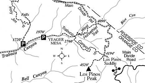
Significant hiking feats can be accomplished in the “wilds” of Orange County, especially in the upper elevations of the Santa Ana Mountains, which define the county’s east border. A case in point is the 10-mile, 2700-foot-elevation-gain hike from Trabuco Canyon to the so-called “Main Divide” of the Santa Anas.
From Trabuco Canyon Road, at the easternmost end of O’Neill Regional Park in Rancho Santa Margarita, turn east on the rough, unpaved Trabuco Creek Road. Drive all the way to the end of the road, nearly six miles, to the Trabuco Canyon Trailhead. Be sure to post a National Forest Adventure Pass on your parked car.
Begin by hiking upstream along the oak- and bigleaf-maple-dotted Trabuco Canyon stream, which will flow with reasonable vigor during the next month or two. Check out the spring wildflowers, which will likely include bush lupine, matilija poppy, paintbrush, wild sweet pea, red and sticky monkeyflowers, prickly phlox, mariposa lily, wild hyacinth, and penstemon.
At 1.8 miles you come to a signed junction where the West Horsethief Trail branches left. Earlier, you probably spotted switchbacks carving up the treeless slope that now lies east of you. After following a canyon bottom for a short while, the West Horsethief Trail begins climbing in earnest, zigzagging through chaparral. During the coolness of the morning, diligent effort will get you to the top of this tedious stretch fast enough; later in the day this could be a hot, energy-sapping climb.
After 1100 feet of elevation gain the trail straightens, begins to level out along a ridge, and enters a vegetation zone dominated by manzanita and blue-flowering ceanothus. Cooler air washes over you, perhaps bearing the scent of the pines that lie ahead.
At 3.3 miles from the Trabuco Canyon Trailhead, the Horsethief Trail joins Main Divide Road in a sparse grove of Coulter pines. Turn right and follow the dirt road east, then south, for an easy, meandering, viewful 2.5 miles.
At 5.8 miles, amid a patch of Coulter pines and incense cedars, you come to Los Pinos Saddle. At the northwest corner of a large, cleared area in the saddle itself, find the old roadbed (Trabuco Canyon Trail) angling downward along the shady slopes of Trabuco Canyon’s main fork. Stands of live oak and big-cone Douglas fir keep this part of the trail well shaded. Flowering currant and ceanothus shrubs at the trailside brighten things up in the spring.
One mile below the saddle, the trail veers left, crosses a divide, and begins descending along a tributary of Trabuco Canyon. You walk by thickets of California bay (bay laurel), which exude an enigmatically pleasant/pungent scent. After crossing the tributary ravine twice, the trail clings to a dry and sunny south-facing slope. Down below, in an almost inaccessible section of the ravine, you may hear water trickling and tumbling over boulders half-hidden under tangles of underbrush and trees.
Before long, you arrive back at the junction of the Horsethief Trail in shady Trabuco Canyon. From there, continue downhill to the Trabuco Canyon Trailhead.
This article contains information about a publicly owned recreation or wilderness area. Trails and pathways are not necessarily marked. Conditions can change rapidly. Hikers should be properly equipped and have safety and navigational skills. The Reader and Jerry Schad assume no responsibility for any adverse experience.
Trabuco Canyon Loop
Climb to the Main Divide of the Santa Ana Mountains for far-ranging views of Riverside County, Orange County, and the ocean.
Distance from downtown San Diego: 85 miles
Hiking length: 10 miles
Difficulty: Strenuous
Here's something you might be interested in.
Trabuco Canyon Loop
Trabuco Canyon Loop
Significant hiking feats can be accomplished in the “wilds” of Orange County, especially in the upper elevations of the Santa Ana Mountains, which define the county’s east border. A case in point is the 10-mile, 2700-foot-elevation-gain hike from Trabuco Canyon to the so-called “Main Divide” of the Santa Anas.
From Trabuco Canyon Road, at the easternmost end of O’Neill Regional Park in Rancho Santa Margarita, turn east on the rough, unpaved Trabuco Creek Road. Drive all the way to the end of the road, nearly six miles, to the Trabuco Canyon Trailhead. Be sure to post a National Forest Adventure Pass on your parked car.
Begin by hiking upstream along the oak- and bigleaf-maple-dotted Trabuco Canyon stream, which will flow with reasonable vigor during the next month or two. Check out the spring wildflowers, which will likely include bush lupine, matilija poppy, paintbrush, wild sweet pea, red and sticky monkeyflowers, prickly phlox, mariposa lily, wild hyacinth, and penstemon.
At 1.8 miles you come to a signed junction where the West Horsethief Trail branches left. Earlier, you probably spotted switchbacks carving up the treeless slope that now lies east of you. After following a canyon bottom for a short while, the West Horsethief Trail begins climbing in earnest, zigzagging through chaparral. During the coolness of the morning, diligent effort will get you to the top of this tedious stretch fast enough; later in the day this could be a hot, energy-sapping climb.
After 1100 feet of elevation gain the trail straightens, begins to level out along a ridge, and enters a vegetation zone dominated by manzanita and blue-flowering ceanothus. Cooler air washes over you, perhaps bearing the scent of the pines that lie ahead.
At 3.3 miles from the Trabuco Canyon Trailhead, the Horsethief Trail joins Main Divide Road in a sparse grove of Coulter pines. Turn right and follow the dirt road east, then south, for an easy, meandering, viewful 2.5 miles.
At 5.8 miles, amid a patch of Coulter pines and incense cedars, you come to Los Pinos Saddle. At the northwest corner of a large, cleared area in the saddle itself, find the old roadbed (Trabuco Canyon Trail) angling downward along the shady slopes of Trabuco Canyon’s main fork. Stands of live oak and big-cone Douglas fir keep this part of the trail well shaded. Flowering currant and ceanothus shrubs at the trailside brighten things up in the spring.
One mile below the saddle, the trail veers left, crosses a divide, and begins descending along a tributary of Trabuco Canyon. You walk by thickets of California bay (bay laurel), which exude an enigmatically pleasant/pungent scent. After crossing the tributary ravine twice, the trail clings to a dry and sunny south-facing slope. Down below, in an almost inaccessible section of the ravine, you may hear water trickling and tumbling over boulders half-hidden under tangles of underbrush and trees.
Before long, you arrive back at the junction of the Horsethief Trail in shady Trabuco Canyon. From there, continue downhill to the Trabuco Canyon Trailhead.
This article contains information about a publicly owned recreation or wilderness area. Trails and pathways are not necessarily marked. Conditions can change rapidly. Hikers should be properly equipped and have safety and navigational skills. The Reader and Jerry Schad assume no responsibility for any adverse experience.
Trabuco Canyon Loop
Climb to the Main Divide of the Santa Ana Mountains for far-ranging views of Riverside County, Orange County, and the ocean.
Distance from downtown San Diego: 85 miles
Hiking length: 10 miles
Difficulty: Strenuous