Here's something you might be interested in.
Ask a Hipster — Advice you didn't know you needed
Big Screen — Movie commentary
Blurt — Music's inside track
Booze News — San Diego spirits
Classical Music — Immortal beauty
Classifieds — Free and easy
Cover Stories — Front-page features
Drinks All Around — Bartenders' drink recipes
Excerpts — Literary and spiritual excerpts
Feast! — Food & drink reviews
Feature Stories — Local news & stories
Fishing Report — What’s getting hooked from ship and shore
From the Archives — Spotlight on the past
Golden Dreams — Talk of the town
The Gonzo Report — Making the musical scene, or at least reporting from it
Letters — Our inbox
Movies@Home — Local movie buffs share favorites
Movie Reviews — Our critics' picks and pans
Musician Interviews — Up close with local artists
Neighborhood News from Stringers — Hyperlocal news
News Ticker — News & politics
Obermeyer — San Diego politics illustrated
Outdoors — Weekly changes in flora and fauna
Overheard in San Diego — Eavesdropping illustrated
Poetry — The old and the new
Reader Travel — Travel section built by travelers
Reading — The hunt for intellectuals
Roam-O-Rama — SoCal's best hiking/biking trails
San Diego Beer — Inside San Diego suds
SD on the QT — Almost factual news
Sheep and Goats — Places of worship
Special Issues — The best of
Street Style — San Diego streets have style
Surf Diego — Real stories from those braving the waves
Theater — On stage in San Diego this week
Tin Fork — Silver spoon alternative
Under the Radar — Matt Potter's undercover work
Unforgettable — Long-ago San Diego
Unreal Estate — San Diego's priciest pads
Your Week — Daily event picks
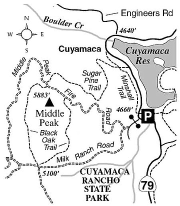
By foot or by bike, circle Middle Peak in the Cuyamaca Mountains.
Middle Peak's north slopes used to feature the "big trees" of Cuyamaca Rancho State Park -- centuries-old sugar pines over 100 feet tall and plenty of black oaks, white firs, Jeffrey pines, and incense cedars. In this post-Cedar Fire era, the primary attraction is the wide-open views available at nearly every level on the slopes of the peak.
To get to the trailhead, follow Highway 79 9.4 miles south from Julian or 13.4 miles north from I-8 at Descanso. You'll see a parking area on the inside of a sharp bend in the road, near the south end of Cuyamaca Reservoir. This trailhead, according to the Highway 79 mile markers, is located at mile 10.7.
The routes described here are separated: one for hikers only and the other for both hikers and bikers. The double-dash-patterned paths on the accompanying map indicate fire roads open to mountain biking. Bikes are not allowed on the Minshall, Sugar Pine, and Black Oak trails.
FOR HIKERS ONLY: From the trailhead, cross over to the west side of the highway and pick up the Minshall Trail, which goes north, parallel to and initially right alongside Highway 79. At about 0.7 mile, the trail pulls away from the highway, turns westward behind some cabins, and joins a dirt road. Continue for 0.2 mile on this dirt road, and then go left on the marked Sugar Pine Trail -- itself an old fire road.
Climb moderately through pioneering shrubs and the blackened remains of formerly dense forest, reversing direction twice. After the second switchback (hairpin turn), patches of bracken fern appear. At 2.5 miles the road passes the foundation of an old cabin and then curves southwest to join Middle Peak Fire Road. Keep left at the intersection, go 50 yards, and then turn left, staying on Middle Peak Fire Road. You're now only 200 vertical feet below and just 0.2 mile north of Middle Peak's rounded summit.
Continue going east on Middle Peak Fire Road, descending slightly for 0.3 mile to the next junction. There, Middle Peak Fire Road veers left and begins a sharp switchbacking drop toward the starting point. Your way, however, goes straight ahead on the east "half" of the Black Oak Trail -- a return route offering a more leisurely descent and a better view in the southerly direction. That vista features the broad, dark flank of Cuyamaca Peak -- and, poking up to the left and separated from the main Cuyamaca crest, boulder-capped Stonewall Peak.
After one mile of descent on the Black Oak Trail, you'll come to a five-way intersection of roads and trails on the saddle between Middle and Cuyamaca peaks. Turn sharply left (east) on Milk Ranch Road, and complete the remaining 1.5-mile stretch back to Highway 79 and the trailhead.
FOR BIKING OR HIKING: The loop consisting of Middle Peak Fire Road and Milk Ranch Road will take you completely around the summit of Middle Peak, with a steady, crooked ascent of the east flank, and a long descent down the west flank. The spacious panorama from the west side may include the ocean -- or more likely at this time of year the marine layer obscuring coastal San Diego County. Middle Peak itself is widely visible from several directions as a gently swelling promontory, so it's no surprise that high on its slopes your view takes in a good deal of San Diego County's landscape.
This article contains information about a publicly owned recreation or wilderness area. Trails and pathways are not necessarily marked. Conditions can change rapidly. Hikers should be properly equipped and have safety and navigational skills. The Reader and Jerry Schad assume no responsibility for any adverse experience.
Here's something you might be interested in.
By foot or by bike, circle Middle Peak in the Cuyamaca Mountains.
By foot or by bike, circle Middle Peak in the Cuyamaca Mountains.
Middle Peak's north slopes used to feature the "big trees" of Cuyamaca Rancho State Park -- centuries-old sugar pines over 100 feet tall and plenty of black oaks, white firs, Jeffrey pines, and incense cedars. In this post-Cedar Fire era, the primary attraction is the wide-open views available at nearly every level on the slopes of the peak.
To get to the trailhead, follow Highway 79 9.4 miles south from Julian or 13.4 miles north from I-8 at Descanso. You'll see a parking area on the inside of a sharp bend in the road, near the south end of Cuyamaca Reservoir. This trailhead, according to the Highway 79 mile markers, is located at mile 10.7.
The routes described here are separated: one for hikers only and the other for both hikers and bikers. The double-dash-patterned paths on the accompanying map indicate fire roads open to mountain biking. Bikes are not allowed on the Minshall, Sugar Pine, and Black Oak trails.
FOR HIKERS ONLY: From the trailhead, cross over to the west side of the highway and pick up the Minshall Trail, which goes north, parallel to and initially right alongside Highway 79. At about 0.7 mile, the trail pulls away from the highway, turns westward behind some cabins, and joins a dirt road. Continue for 0.2 mile on this dirt road, and then go left on the marked Sugar Pine Trail -- itself an old fire road.
Climb moderately through pioneering shrubs and the blackened remains of formerly dense forest, reversing direction twice. After the second switchback (hairpin turn), patches of bracken fern appear. At 2.5 miles the road passes the foundation of an old cabin and then curves southwest to join Middle Peak Fire Road. Keep left at the intersection, go 50 yards, and then turn left, staying on Middle Peak Fire Road. You're now only 200 vertical feet below and just 0.2 mile north of Middle Peak's rounded summit.
Continue going east on Middle Peak Fire Road, descending slightly for 0.3 mile to the next junction. There, Middle Peak Fire Road veers left and begins a sharp switchbacking drop toward the starting point. Your way, however, goes straight ahead on the east "half" of the Black Oak Trail -- a return route offering a more leisurely descent and a better view in the southerly direction. That vista features the broad, dark flank of Cuyamaca Peak -- and, poking up to the left and separated from the main Cuyamaca crest, boulder-capped Stonewall Peak.
After one mile of descent on the Black Oak Trail, you'll come to a five-way intersection of roads and trails on the saddle between Middle and Cuyamaca peaks. Turn sharply left (east) on Milk Ranch Road, and complete the remaining 1.5-mile stretch back to Highway 79 and the trailhead.
FOR BIKING OR HIKING: The loop consisting of Middle Peak Fire Road and Milk Ranch Road will take you completely around the summit of Middle Peak, with a steady, crooked ascent of the east flank, and a long descent down the west flank. The spacious panorama from the west side may include the ocean -- or more likely at this time of year the marine layer obscuring coastal San Diego County. Middle Peak itself is widely visible from several directions as a gently swelling promontory, so it's no surprise that high on its slopes your view takes in a good deal of San Diego County's landscape.
This article contains information about a publicly owned recreation or wilderness area. Trails and pathways are not necessarily marked. Conditions can change rapidly. Hikers should be properly equipped and have safety and navigational skills. The Reader and Jerry Schad assume no responsibility for any adverse experience.