Here's something you might be interested in.
Ask a Hipster — Advice you didn't know you needed
Big Screen — Movie commentary
Blurt — Music's inside track
Booze News — San Diego spirits
Classical Music — Immortal beauty
Classifieds — Free and easy
Cover Stories — Front-page features
Drinks All Around — Bartenders' drink recipes
Excerpts — Literary and spiritual excerpts
Feast! — Food & drink reviews
Feature Stories — Local news & stories
Fishing Report — What’s getting hooked from ship and shore
From the Archives — Spotlight on the past
Golden Dreams — Talk of the town
The Gonzo Report — Making the musical scene, or at least reporting from it
Letters — Our inbox
Movies@Home — Local movie buffs share favorites
Movie Reviews — Our critics' picks and pans
Musician Interviews — Up close with local artists
Neighborhood News from Stringers — Hyperlocal news
News Ticker — News & politics
Obermeyer — San Diego politics illustrated
Outdoors — Weekly changes in flora and fauna
Overheard in San Diego — Eavesdropping illustrated
Poetry — The old and the new
Reader Travel — Travel section built by travelers
Reading — The hunt for intellectuals
Roam-O-Rama — SoCal's best hiking/biking trails
San Diego Beer — Inside San Diego suds
SD on the QT — Almost factual news
Sheep and Goats — Places of worship
Special Issues — The best of
Street Style — San Diego streets have style
Surf Diego — Real stories from those braving the waves
Theater — On stage in San Diego this week
Tin Fork — Silver spoon alternative
Under the Radar — Matt Potter's undercover work
Unforgettable — Long-ago San Diego
Unreal Estate — San Diego's priciest pads
Your Week — Daily event picks
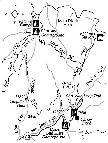
Scope out soaring birds, wildflowers, and a waterfall on the Chiquito Trail near Ortega Highway.
The Chiquito Trail, a multiuse (hiking, mountain biking, horseback riding) route down from Blue Jay Campground to Ortega Highway in the Santa Ana Mountains, is best explored (if hiking) in the one-way, downhill direction. Mountain bikers can use the local roads to fashion a loop. Along the trail you can enjoy cool passages through canyon bottoms and a long, view-rich traverse across a sunny ridge.
Your expedition begins just outside the campground, which is 2.5 miles up Long Canyon Road from Ortega Highway. It ends along Ortega Highway itself at the San Juan Loop Trail parking lot, which is opposite a local landmark called the Candy Store. The store is 21 miles east of Interstate 5 at San Juan Capistrano and about 10 miles west of Lake Elsinore near Interstate 15.
The starting point is actually the upper terminus for the San Juan Trail, which wends its way west for many miles, ending at a place called Hot Spring Canyon. You go only 1.8 miles downhill on the gently meandering San Juan Trail to the Chiquito Trail junction, and make a left turn there.
On the Chiquito Trail you descend east into the upper reaches of Lion Canyon, which normally has water flowing in it through the spring and early summer. In the next two miles you follow the bottom of Lion Canyon, downhill. That stretch is delightful, with patchy shade provided by large oaks -- the survivors of wildfires -- and young sycamores. On the banks of the creek you'll find poison oak (which hopefully you can identify and avoid); wild blackberry vines; toyon bushes; barberry shrubs; and ceanothus shrubs (aka "wild lilac"). Profuse displays of monkeyflower brighten the scene in April and May. The red monkeyflower and the sticky (yellow-flowered) monkeyflower may have hybridized here: the spectrum of monkeyflower colors includes orange, pink, and magenta, as well as the usual scarlet and light yellow hues.
At 4.2 miles, the trail makes an abrupt bend to the left and begins a long traverse across the ridge to the east. Just below this bend is Chiquito Falls, where the stream drops about 15 feet over an outcrop of granite. Impressive only after heavy rains, the site is a pleasant one anytime for a picnic.
Rising through scrubby chaparral and granitic boulders, the trail works around to a south-facing slope. The din of traffic from Ortega Highway less than one bee-line mile away is enough to convince you the end is near, but it's not. Instead, the trail curves northeast and crookedly descends for another two miles to a tributary of San Juan Canyon. During the long, downward traverse, look for hawks and golden eagles riding the thermals, and squirrels or lizards scurrying around at ground level.
Once you are in the tributary (wet or dry, depending on the amount of recent rainfall) you continue one more mile to the wide creek in San Juan Canyon. The popular San Juan Loop Trail lies across that creek. Go either right or left (going left is the simpler alternative) around the loop to reach the parking lot opposite the Candy Store.
This article contains information about a publicly owned recreation or wilderness area. Trails and pathways are not necessarily marked. Conditions can change rapidly. Hikers should be properly equipped and have safety and navigational skills. The Reader and Jerry Schad assume no responsibility for any adverse experience.
Here's something you might be interested in.
Scope out soaring birds, wildflowers, and a waterfall on the Chiquito Trail near Ortega Highway.
Scope out soaring birds, wildflowers, and a waterfall on the Chiquito Trail near Ortega Highway.
The Chiquito Trail, a multiuse (hiking, mountain biking, horseback riding) route down from Blue Jay Campground to Ortega Highway in the Santa Ana Mountains, is best explored (if hiking) in the one-way, downhill direction. Mountain bikers can use the local roads to fashion a loop. Along the trail you can enjoy cool passages through canyon bottoms and a long, view-rich traverse across a sunny ridge.
Your expedition begins just outside the campground, which is 2.5 miles up Long Canyon Road from Ortega Highway. It ends along Ortega Highway itself at the San Juan Loop Trail parking lot, which is opposite a local landmark called the Candy Store. The store is 21 miles east of Interstate 5 at San Juan Capistrano and about 10 miles west of Lake Elsinore near Interstate 15.
The starting point is actually the upper terminus for the San Juan Trail, which wends its way west for many miles, ending at a place called Hot Spring Canyon. You go only 1.8 miles downhill on the gently meandering San Juan Trail to the Chiquito Trail junction, and make a left turn there.
On the Chiquito Trail you descend east into the upper reaches of Lion Canyon, which normally has water flowing in it through the spring and early summer. In the next two miles you follow the bottom of Lion Canyon, downhill. That stretch is delightful, with patchy shade provided by large oaks -- the survivors of wildfires -- and young sycamores. On the banks of the creek you'll find poison oak (which hopefully you can identify and avoid); wild blackberry vines; toyon bushes; barberry shrubs; and ceanothus shrubs (aka "wild lilac"). Profuse displays of monkeyflower brighten the scene in April and May. The red monkeyflower and the sticky (yellow-flowered) monkeyflower may have hybridized here: the spectrum of monkeyflower colors includes orange, pink, and magenta, as well as the usual scarlet and light yellow hues.
At 4.2 miles, the trail makes an abrupt bend to the left and begins a long traverse across the ridge to the east. Just below this bend is Chiquito Falls, where the stream drops about 15 feet over an outcrop of granite. Impressive only after heavy rains, the site is a pleasant one anytime for a picnic.
Rising through scrubby chaparral and granitic boulders, the trail works around to a south-facing slope. The din of traffic from Ortega Highway less than one bee-line mile away is enough to convince you the end is near, but it's not. Instead, the trail curves northeast and crookedly descends for another two miles to a tributary of San Juan Canyon. During the long, downward traverse, look for hawks and golden eagles riding the thermals, and squirrels or lizards scurrying around at ground level.
Once you are in the tributary (wet or dry, depending on the amount of recent rainfall) you continue one more mile to the wide creek in San Juan Canyon. The popular San Juan Loop Trail lies across that creek. Go either right or left (going left is the simpler alternative) around the loop to reach the parking lot opposite the Candy Store.
This article contains information about a publicly owned recreation or wilderness area. Trails and pathways are not necessarily marked. Conditions can change rapidly. Hikers should be properly equipped and have safety and navigational skills. The Reader and Jerry Schad assume no responsibility for any adverse experience.