Here's something you might be interested in.
Ask a Hipster — Advice you didn't know you needed
Big Screen — Movie commentary
Blurt — Music's inside track
Booze News — San Diego spirits
Classical Music — Immortal beauty
Classifieds — Free and easy
Cover Stories — Front-page features
Drinks All Around — Bartenders' drink recipes
Excerpts — Literary and spiritual excerpts
Feast! — Food & drink reviews
Feature Stories — Local news & stories
Fishing Report — What’s getting hooked from ship and shore
From the Archives — Spotlight on the past
Golden Dreams — Talk of the town
The Gonzo Report — Making the musical scene, or at least reporting from it
Letters — Our inbox
Movies@Home — Local movie buffs share favorites
Movie Reviews — Our critics' picks and pans
Musician Interviews — Up close with local artists
Neighborhood News from Stringers — Hyperlocal news
News Ticker — News & politics
Obermeyer — San Diego politics illustrated
Outdoors — Weekly changes in flora and fauna
Overheard in San Diego — Eavesdropping illustrated
Poetry — The old and the new
Reader Travel — Travel section built by travelers
Reading — The hunt for intellectuals
Roam-O-Rama — SoCal's best hiking/biking trails
San Diego Beer — Inside San Diego suds
SD on the QT — Almost factual news
Sheep and Goats — Places of worship
Special Issues — The best of
Street Style — San Diego streets have style
Surf Diego — Real stories from those braving the waves
Theater — On stage in San Diego this week
Tin Fork — Silver spoon alternative
Under the Radar — Matt Potter's undercover work
Unforgettable — Long-ago San Diego
Unreal Estate — San Diego's priciest pads
Your Week — Daily event picks
The Pacific Crest Trail follows the currently lively Agua Caliente Creek near Warner Springs
Until about 30 years ago, the canyon of Agua Caliente Creek, in the Cleveland National Forest above Warner Springs, seldom saw the intrusion of humans. After the 2600-mile-long Pacific Crest Trail was routed through, it became recognized as a pleasant camping spot for backpackers heading north toward Canada or south toward Mexico. This is one of only four places in San Diego County where the PCT dips to cross a fairly dependable stream, and the only place in the county where that trail closely follows running water for a fair distance. You can walk a total of eight miles round trip (out and back) to enjoy the most interesting stretch of the canyon.
Begin at the Agua Caliente Creek bridge at mile 36.6 on Highway 79, 1.3 miles west of Warner Springs. There's a turnout for parking just west (mile 36.7) and a dirt road slanting over to where the PCT crosses under the highway. Proceed upstream along the cottonwood-shaded creek, first on the left (north) bank, then on the right. In this first mile, the trail goes through Warner Ranch resort property on an easement. Near the Cleveland National Forest boundary, the canyon narrows, and water trickes or gushes (depending on recent rainfall) out of a narrow declivity.
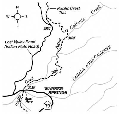
The trail detours a rough section of canyon ahead by swinging to the east and climbing moderately onto gentle slopes smothered with soft-looking ribbonwood chaparral, and sparsely dotted with cholla and prickly pear cactus. Horseback riders have worn in trails that intersect the PCT here and there, so staying on the correct route may prove a little challenging. After about 1.5 miles of somewhat tedious twisting and turning in the chaparral, you end up down along the bank of the creek again.
Ahead, for a mile or more, lies an appealing stretch of twisting canyon bottom, lined with live oaks, sycamores, and willows, all festooned this month with fresh green leaves. The PCT crosses the creek several times (these may be foot-wetting fords during the next month or two) and strikes up-slope to avoid the rockier, rougher stretches of the canyon bottom. Eventually, the trail veers sharply left and begins a switchbacking ascent northwest up dry slopes toward Lost Valley Road. You've come four miles and reached a good spot to turn around and return the same way.
This article contains information about a publicly owned recreation or wilderness area. Trails and pathways are not necessarily marked. Conditions can change rapidly. Hikers should be properly equipped and have safety and navigational skills. The Reader and Jerry Schad assume no responsibility for any detrimental experience.
Here's something you might be interested in.
The Pacific Crest Trail follows the currently lively Agua Caliente Creek near Warner Springs
The Pacific Crest Trail follows the currently lively Agua Caliente Creek near Warner Springs
Until about 30 years ago, the canyon of Agua Caliente Creek, in the Cleveland National Forest above Warner Springs, seldom saw the intrusion of humans. After the 2600-mile-long Pacific Crest Trail was routed through, it became recognized as a pleasant camping spot for backpackers heading north toward Canada or south toward Mexico. This is one of only four places in San Diego County where the PCT dips to cross a fairly dependable stream, and the only place in the county where that trail closely follows running water for a fair distance. You can walk a total of eight miles round trip (out and back) to enjoy the most interesting stretch of the canyon.
Begin at the Agua Caliente Creek bridge at mile 36.6 on Highway 79, 1.3 miles west of Warner Springs. There's a turnout for parking just west (mile 36.7) and a dirt road slanting over to where the PCT crosses under the highway. Proceed upstream along the cottonwood-shaded creek, first on the left (north) bank, then on the right. In this first mile, the trail goes through Warner Ranch resort property on an easement. Near the Cleveland National Forest boundary, the canyon narrows, and water trickes or gushes (depending on recent rainfall) out of a narrow declivity.
The trail detours a rough section of canyon ahead by swinging to the east and climbing moderately onto gentle slopes smothered with soft-looking ribbonwood chaparral, and sparsely dotted with cholla and prickly pear cactus. Horseback riders have worn in trails that intersect the PCT here and there, so staying on the correct route may prove a little challenging. After about 1.5 miles of somewhat tedious twisting and turning in the chaparral, you end up down along the bank of the creek again.
Ahead, for a mile or more, lies an appealing stretch of twisting canyon bottom, lined with live oaks, sycamores, and willows, all festooned this month with fresh green leaves. The PCT crosses the creek several times (these may be foot-wetting fords during the next month or two) and strikes up-slope to avoid the rockier, rougher stretches of the canyon bottom. Eventually, the trail veers sharply left and begins a switchbacking ascent northwest up dry slopes toward Lost Valley Road. You've come four miles and reached a good spot to turn around and return the same way.
This article contains information about a publicly owned recreation or wilderness area. Trails and pathways are not necessarily marked. Conditions can change rapidly. Hikers should be properly equipped and have safety and navigational skills. The Reader and Jerry Schad assume no responsibility for any detrimental experience.
Comments