Here's something you might be interested in.
Ask a Hipster — Advice you didn't know you needed
Big Screen — Movie commentary
Blurt — Music's inside track
Booze News — San Diego spirits
Classical Music — Immortal beauty
Classifieds — Free and easy
Cover Stories — Front-page features
Drinks All Around — Bartenders' drink recipes
Excerpts — Literary and spiritual excerpts
Feast! — Food & drink reviews
Feature Stories — Local news & stories
Fishing Report — What’s getting hooked from ship and shore
From the Archives — Spotlight on the past
Golden Dreams — Talk of the town
The Gonzo Report — Making the musical scene, or at least reporting from it
Letters — Our inbox
Movies@Home — Local movie buffs share favorites
Movie Reviews — Our critics' picks and pans
Musician Interviews — Up close with local artists
Neighborhood News from Stringers — Hyperlocal news
News Ticker — News & politics
Obermeyer — San Diego politics illustrated
Outdoors — Weekly changes in flora and fauna
Overheard in San Diego — Eavesdropping illustrated
Poetry — The old and the new
Reader Travel — Travel section built by travelers
Reading — The hunt for intellectuals
Roam-O-Rama — SoCal's best hiking/biking trails
San Diego Beer — Inside San Diego suds
SD on the QT — Almost factual news
Sheep and Goats — Places of worship
Special Issues — The best of
Street Style — San Diego streets have style
Surf Diego — Real stories from those braving the waves
Theater — On stage in San Diego this week
Tin Fork — Silver spoon alternative
Under the Radar — Matt Potter's undercover work
Unforgettable — Long-ago San Diego
Unreal Estate — San Diego's priciest pads
Your Week — Daily event picks
Ramble along the shore of El Capitan Reservoir
Trace the route of one of San Diego's early water-delivery systems.
Little remains of the century-old, redwood-planked flume (aqueduct) that once brought the waters of the Cuyamaca Mountains to Grossmont Summit and farther west. Much of the flume's 36-mile-long grade is hard to identify, since no fill dirt was used to maintain the flume's uniform fall of 4 feet, 8 inches to the mile. Instead, workers employed numerous cuts, several tunnels, and more than 300 trestles. The completion and filling of El Capitan Reservoir in the 1930s put an end to the flume's usefulness. The 9 million board-feet of lumber used for the flume itself and for the trestles were scavenged a long time ago.
A 3.5-mile section of the flume's near-flat earthen grade along the east shore of El Capitan Reservoir is easily visible to the eye, and fairly easy to follow, once you are actually on it. A pleasant surprise awaits hikers at the far end of this stretch.
Start at the concession area of El Capitan Reservoir, at the far-east end of El Monte Road, east of Lakeside. The reservoir is open sunrise to sunset, Friday through Sunday only, beginning on February 3 (visit www.sandiego.gov/water/recreation/ for more information). A day-use fee is charged on entry to the reservoir area. Be sure to take plenty of drinking water on your trek, especially if the day is warm and sunny.
Your first and most difficult task is to flounder across the muddy bottom of the reservoir near its south end, where the waters of Chocolate Canyon and a smaller stream flowing downward from Peutz Valley enter the south arm of the reservoir. These two creek crossings were only slightly foot-wetting a couple of weeks ago — but soaking rains later this winter could induce more runoff, and water levels in the reservoir could rise, making the task more difficult.
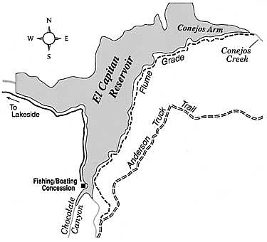
Aim for the flat "shelf" cut into the hillside east of the lake just above the high-water line. The redwood structure of the flume followed this nearly flat bed. Continue north and east for more than three miles on a trail moderately overgrown by weedy grasses that have sprouted up since the 2003 Cedar Fire. As you get closer to Conejos Creek, there are detours where the path darts above or below the original level of the flume. The footing there may be treacherous. When you reach the spot where the flume grade crosses Conejos Creek, you'll discover a sublime sylvan scene, with water darting over and around boulders and century-old masonry associated with the flume. The trees and low-growing vegetation here are about 2.5 years into their recovery cycle following the Cedar Fire.
Here's something you might be interested in.
Ramble along the shore of El Capitan Reservoir
Trace the route of one of San Diego's early water-delivery systems.
Ramble along the shore of El Capitan Reservoir
Trace the route of one of San Diego's early water-delivery systems.
Little remains of the century-old, redwood-planked flume (aqueduct) that once brought the waters of the Cuyamaca Mountains to Grossmont Summit and farther west. Much of the flume's 36-mile-long grade is hard to identify, since no fill dirt was used to maintain the flume's uniform fall of 4 feet, 8 inches to the mile. Instead, workers employed numerous cuts, several tunnels, and more than 300 trestles. The completion and filling of El Capitan Reservoir in the 1930s put an end to the flume's usefulness. The 9 million board-feet of lumber used for the flume itself and for the trestles were scavenged a long time ago.
A 3.5-mile section of the flume's near-flat earthen grade along the east shore of El Capitan Reservoir is easily visible to the eye, and fairly easy to follow, once you are actually on it. A pleasant surprise awaits hikers at the far end of this stretch.
Start at the concession area of El Capitan Reservoir, at the far-east end of El Monte Road, east of Lakeside. The reservoir is open sunrise to sunset, Friday through Sunday only, beginning on February 3 (visit www.sandiego.gov/water/recreation/ for more information). A day-use fee is charged on entry to the reservoir area. Be sure to take plenty of drinking water on your trek, especially if the day is warm and sunny.
Your first and most difficult task is to flounder across the muddy bottom of the reservoir near its south end, where the waters of Chocolate Canyon and a smaller stream flowing downward from Peutz Valley enter the south arm of the reservoir. These two creek crossings were only slightly foot-wetting a couple of weeks ago — but soaking rains later this winter could induce more runoff, and water levels in the reservoir could rise, making the task more difficult.
Aim for the flat "shelf" cut into the hillside east of the lake just above the high-water line. The redwood structure of the flume followed this nearly flat bed. Continue north and east for more than three miles on a trail moderately overgrown by weedy grasses that have sprouted up since the 2003 Cedar Fire. As you get closer to Conejos Creek, there are detours where the path darts above or below the original level of the flume. The footing there may be treacherous. When you reach the spot where the flume grade crosses Conejos Creek, you'll discover a sublime sylvan scene, with water darting over and around boulders and century-old masonry associated with the flume. The trees and low-growing vegetation here are about 2.5 years into their recovery cycle following the Cedar Fire.
Comments