Here's something you might be interested in.
Ask a Hipster — Advice you didn't know you needed
Big Screen — Movie commentary
Blurt — Music's inside track
Booze News — San Diego spirits
Classical Music — Immortal beauty
Classifieds — Free and easy
Cover Stories — Front-page features
Drinks All Around — Bartenders' drink recipes
Excerpts — Literary and spiritual excerpts
Feast! — Food & drink reviews
Feature Stories — Local news & stories
Fishing Report — What’s getting hooked from ship and shore
From the Archives — Spotlight on the past
Golden Dreams — Talk of the town
The Gonzo Report — Making the musical scene, or at least reporting from it
Letters — Our inbox
Movies@Home — Local movie buffs share favorites
Movie Reviews — Our critics' picks and pans
Musician Interviews — Up close with local artists
Neighborhood News from Stringers — Hyperlocal news
News Ticker — News & politics
Obermeyer — San Diego politics illustrated
Outdoors — Weekly changes in flora and fauna
Overheard in San Diego — Eavesdropping illustrated
Poetry — The old and the new
Reader Travel — Travel section built by travelers
Reading — The hunt for intellectuals
Roam-O-Rama — SoCal's best hiking/biking trails
San Diego Beer — Inside San Diego suds
SD on the QT — Almost factual news
Sheep and Goats — Places of worship
Special Issues — The best of
Street Style — San Diego streets have style
Surf Diego — Real stories from those braving the waves
Theater — On stage in San Diego this week
Tin Fork — Silver spoon alternative
Under the Radar — Matt Potter's undercover work
Unforgettable — Long-ago San Diego
Unreal Estate — San Diego's priciest pads
Your Week — Daily event picks
As the Anza-Borrego Desert cools from torrid to merely warm, try a refreshing hike to the viewful summit of Mine Peak.
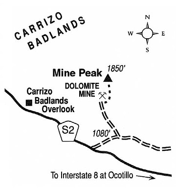
Mine Peak, elevation 1850 feet above sea level, stands atop the west end of the Coyote Mountains in far-southern Anza-Borrego Desert State Park. On a clear fall or winter day atop Mine Peak, the view seems to go on forever, with the rounded, fractal landscape of the Carrizo Badlands in the north, the cobbled Tierra Blanca, In-Ko-Pah, and Jacumba mountains to the west through south, and the flat, hazy Yuha Desert and Salton Basin to the southeast and northeast. October high temperatures are falling fast in the desert -- from 90s early in the month to 80s by month's end -- so it isn't too early in the season to explore here as long as you avoid hiking during midday or early afternoon.
The Coyote Mountains have a core of uplifted ancient granitic and metamorphic rocks overlain by marine sediments. Some five million years ago, much of this same landscape lay below sea level and underneath a shallow sea occupying the southeastern corner of California. In the millions of years since, the layers of oozy sediment that had accumulated on the sea bottom were uplifted by the action of tectonic forces related to those that tore Baja California away from mainland Mexico. Erosion quickly cut through the softest mud deposits, leaving somewhat harder sandstones and fossil-shell reefs exposed -- as you can see today at Fossil Canyon, Painted Gorge, and other areas at the east end of the Coyote Mountains in Imperial County. On the west end of the Coyote Mountains, at Mine Peak, the much older, underlying metamorphic and granitic rocks now poke head and shoulders above all the softer stuff.
To mount a mini-expedition to Mine Peak's summit, exit Interstate 8 at Ocotillo, and proceed north and west on County Highway S-2 for eight miles into Anza-Borrego Desert State Park. Watch the roadside mile markers from that point on. At mile 53.4 according to the markers, turn right onto the West Dolomite Mine Trail (a dirt road). Drive 0.7 mile -- if the toughness of your automobile allows it -- then turn sharply left (north). Go 0.2 mile to a large parking area and stop. Beyond this point, the road sharply deteriorates, so it's better if you're on foot from then on. Cross a wash and continue up the old road 0.6 mile to an abandoned dolomite mine. From there, simply scramble straight up the rock-strewn ridge, due north, to reach the rounded summit of Mine Peak, another 0.6 mile away.
Here's something you might be interested in.
As the Anza-Borrego Desert cools from torrid to merely warm, try a refreshing hike to the viewful summit of Mine Peak.
As the Anza-Borrego Desert cools from torrid to merely warm, try a refreshing hike to the viewful summit of Mine Peak.
Mine Peak, elevation 1850 feet above sea level, stands atop the west end of the Coyote Mountains in far-southern Anza-Borrego Desert State Park. On a clear fall or winter day atop Mine Peak, the view seems to go on forever, with the rounded, fractal landscape of the Carrizo Badlands in the north, the cobbled Tierra Blanca, In-Ko-Pah, and Jacumba mountains to the west through south, and the flat, hazy Yuha Desert and Salton Basin to the southeast and northeast. October high temperatures are falling fast in the desert -- from 90s early in the month to 80s by month's end -- so it isn't too early in the season to explore here as long as you avoid hiking during midday or early afternoon.
The Coyote Mountains have a core of uplifted ancient granitic and metamorphic rocks overlain by marine sediments. Some five million years ago, much of this same landscape lay below sea level and underneath a shallow sea occupying the southeastern corner of California. In the millions of years since, the layers of oozy sediment that had accumulated on the sea bottom were uplifted by the action of tectonic forces related to those that tore Baja California away from mainland Mexico. Erosion quickly cut through the softest mud deposits, leaving somewhat harder sandstones and fossil-shell reefs exposed -- as you can see today at Fossil Canyon, Painted Gorge, and other areas at the east end of the Coyote Mountains in Imperial County. On the west end of the Coyote Mountains, at Mine Peak, the much older, underlying metamorphic and granitic rocks now poke head and shoulders above all the softer stuff.
To mount a mini-expedition to Mine Peak's summit, exit Interstate 8 at Ocotillo, and proceed north and west on County Highway S-2 for eight miles into Anza-Borrego Desert State Park. Watch the roadside mile markers from that point on. At mile 53.4 according to the markers, turn right onto the West Dolomite Mine Trail (a dirt road). Drive 0.7 mile -- if the toughness of your automobile allows it -- then turn sharply left (north). Go 0.2 mile to a large parking area and stop. Beyond this point, the road sharply deteriorates, so it's better if you're on foot from then on. Cross a wash and continue up the old road 0.6 mile to an abandoned dolomite mine. From there, simply scramble straight up the rock-strewn ridge, due north, to reach the rounded summit of Mine Peak, another 0.6 mile away.