Here's something you might be interested in.
Ask a Hipster — Advice you didn't know you needed
Big Screen — Movie commentary
Blurt — Music's inside track
Booze News — San Diego spirits
Classical Music — Immortal beauty
Classifieds — Free and easy
Cover Stories — Front-page features
Drinks All Around — Bartenders' drink recipes
Excerpts — Literary and spiritual excerpts
Feast! — Food & drink reviews
Feature Stories — Local news & stories
Fishing Report — What’s getting hooked from ship and shore
From the Archives — Spotlight on the past
Golden Dreams — Talk of the town
The Gonzo Report — Making the musical scene, or at least reporting from it
Letters — Our inbox
Movies@Home — Local movie buffs share favorites
Movie Reviews — Our critics' picks and pans
Musician Interviews — Up close with local artists
Neighborhood News from Stringers — Hyperlocal news
News Ticker — News & politics
Obermeyer — San Diego politics illustrated
Outdoors — Weekly changes in flora and fauna
Overheard in San Diego — Eavesdropping illustrated
Poetry — The old and the new
Reader Travel — Travel section built by travelers
Reading — The hunt for intellectuals
Roam-O-Rama — SoCal's best hiking/biking trails
San Diego Beer — Inside San Diego suds
SD on the QT — Almost factual news
Sheep and Goats — Places of worship
Special Issues — The best of
Street Style — San Diego streets have style
Surf Diego — Real stories from those braving the waves
Theater — On stage in San Diego this week
Tin Fork — Silver spoon alternative
Under the Radar — Matt Potter's undercover work
Unforgettable — Long-ago San Diego
Unreal Estate — San Diego's priciest pads
Your Week — Daily event picks
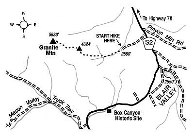
Boulder-hop to the top of Granite Mountain, overlooking the Anza-Borrego Desert.
Granite Mountain massively swells along the western edge of the Anza-Borrego Desert, its flattish summit presiding over hundreds of square miles of brown desert to the east and the timber-dotted Laguna and Cuyamaca Mountains toward the south and west. No trail traverses Granite Mountain's upper flanks -- though it's possible to approach the summit from nearly every point on the compass. The Pacific Crest Trail meanders low around the mountain's north flank but never approaches the top close enough to be much good in facilitating a summit bid. The following route breathes life into a task that, on some routes, can be tedious.
The hike, measuring 6.5 miles round-trip and with an elevation gain and loss of 3200 feet, is no Sunday-picnic stroll. It is trailless and rocky throughout and could require a full day of hiking for some people. Hiking boots with good ankle support are essential. Since the climb is waterless, bring two liters of water if the day is cool, and much more if it's warm. Do it no later than March to take advantage of moderate weather and air that's likely to be dry and transparent. This year's early and prolific blooming of desert vegetation will make the experience even more interesting.
From Scissors Crossing (an offset highway junction 12 miles east of Julian on State Highway 78), turn south on County Highway S2. Continue 4.5 miles southwest, passing through the small community of Shelter Valley. At mile 21.5 according to the highway mile markers, just beyond the Anza-Borrego Desert State Park boundary, turn right on a dirt road and follow it approximately one mile west to its end at the foot of Granite Mountain.
On foot, proceed up the dry canyon just ahead and continue through a rock-walled portal. After only 0.2 mile the canyon divides. Take the left (major, south) fork, passing over several easy-to-climb dry "falls." After another three-quarters of a mile the canyon splits into three forks. Go about 100 yards into the right (northwest) fork, and veer left to climb the ridge between the northwest and west forks. You climb moderately at first through sparse growths of cacti and small, brittle shrubs. Later, you'll be scrambling over or around large boulders.
By staying near the ridgeline and never descending, you reach a false summit -- elevation 4624 feet -- after perhaps one or two hours of effort. This view-rich peaklet is a worthy destination in itself for those who don't wish to go on. From this vantage point, look east to identify and memorize the route you took on the way up. You will be returning to your car on the same route.
The true 5633-foot summit of Granite Mountain lies farther along the ridgeline to the west, clothed in scattered piñon pine and juniper and tough but not impenetrable chaparral. After many leg- or arm-scratching encounters with the brush, you reach the topmost boulder pile -- with its inclusive view. On the far north horizon rise the 10,000-plus-foot summits of Old Baldy, San Jacinto Peak, and San Gorgonio Mountain. The Salton Sea spreads to the east. On rare occasions -- over Julian to the west -- you can even spot far-off Santa Catalina Island and San Clemente Island.
Here's something you might be interested in.
Boulder-hop to the top of Granite Mountain, overlooking the Anza-Borrego Desert.
Boulder-hop to the top of Granite Mountain, overlooking the Anza-Borrego Desert.
Granite Mountain massively swells along the western edge of the Anza-Borrego Desert, its flattish summit presiding over hundreds of square miles of brown desert to the east and the timber-dotted Laguna and Cuyamaca Mountains toward the south and west. No trail traverses Granite Mountain's upper flanks -- though it's possible to approach the summit from nearly every point on the compass. The Pacific Crest Trail meanders low around the mountain's north flank but never approaches the top close enough to be much good in facilitating a summit bid. The following route breathes life into a task that, on some routes, can be tedious.
The hike, measuring 6.5 miles round-trip and with an elevation gain and loss of 3200 feet, is no Sunday-picnic stroll. It is trailless and rocky throughout and could require a full day of hiking for some people. Hiking boots with good ankle support are essential. Since the climb is waterless, bring two liters of water if the day is cool, and much more if it's warm. Do it no later than March to take advantage of moderate weather and air that's likely to be dry and transparent. This year's early and prolific blooming of desert vegetation will make the experience even more interesting.
From Scissors Crossing (an offset highway junction 12 miles east of Julian on State Highway 78), turn south on County Highway S2. Continue 4.5 miles southwest, passing through the small community of Shelter Valley. At mile 21.5 according to the highway mile markers, just beyond the Anza-Borrego Desert State Park boundary, turn right on a dirt road and follow it approximately one mile west to its end at the foot of Granite Mountain.
On foot, proceed up the dry canyon just ahead and continue through a rock-walled portal. After only 0.2 mile the canyon divides. Take the left (major, south) fork, passing over several easy-to-climb dry "falls." After another three-quarters of a mile the canyon splits into three forks. Go about 100 yards into the right (northwest) fork, and veer left to climb the ridge between the northwest and west forks. You climb moderately at first through sparse growths of cacti and small, brittle shrubs. Later, you'll be scrambling over or around large boulders.
By staying near the ridgeline and never descending, you reach a false summit -- elevation 4624 feet -- after perhaps one or two hours of effort. This view-rich peaklet is a worthy destination in itself for those who don't wish to go on. From this vantage point, look east to identify and memorize the route you took on the way up. You will be returning to your car on the same route.
The true 5633-foot summit of Granite Mountain lies farther along the ridgeline to the west, clothed in scattered piñon pine and juniper and tough but not impenetrable chaparral. After many leg- or arm-scratching encounters with the brush, you reach the topmost boulder pile -- with its inclusive view. On the far north horizon rise the 10,000-plus-foot summits of Old Baldy, San Jacinto Peak, and San Gorgonio Mountain. The Salton Sea spreads to the east. On rare occasions -- over Julian to the west -- you can even spot far-off Santa Catalina Island and San Clemente Island.