Here's something you might be interested in.
Ask a Hipster — Advice you didn't know you needed
Big Screen — Movie commentary
Blurt — Music's inside track
Booze News — San Diego spirits
Classical Music — Immortal beauty
Classifieds — Free and easy
Cover Stories — Front-page features
Drinks All Around — Bartenders' drink recipes
Excerpts — Literary and spiritual excerpts
Feast! — Food & drink reviews
Feature Stories — Local news & stories
Fishing Report — What’s getting hooked from ship and shore
From the Archives — Spotlight on the past
Golden Dreams — Talk of the town
The Gonzo Report — Making the musical scene, or at least reporting from it
Letters — Our inbox
Movies@Home — Local movie buffs share favorites
Movie Reviews — Our critics' picks and pans
Musician Interviews — Up close with local artists
Neighborhood News from Stringers — Hyperlocal news
News Ticker — News & politics
Obermeyer — San Diego politics illustrated
Outdoors — Weekly changes in flora and fauna
Overheard in San Diego — Eavesdropping illustrated
Poetry — The old and the new
Reader Travel — Travel section built by travelers
Reading — The hunt for intellectuals
Roam-O-Rama — SoCal's best hiking/biking trails
San Diego Beer — Inside San Diego suds
SD on the QT — Almost factual news
Sheep and Goats — Places of worship
Special Issues — The best of
Street Style — San Diego streets have style
Surf Diego — Real stories from those braving the waves
Theater — On stage in San Diego this week
Tin Fork — Silver spoon alternative
Under the Radar — Matt Potter's undercover work
Unforgettable — Long-ago San Diego
Unreal Estate — San Diego's priciest pads
Your Week — Daily event picks
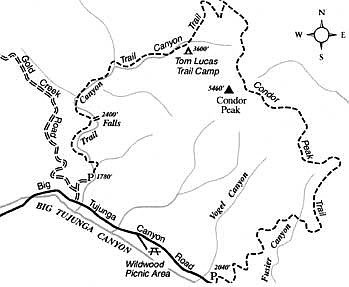
Discover Trail Canyon Falls, tucked away in a remote crease of the San Gabriel Mountains.
Rising starkly behind the San Fernando and Crescenta valley communities of Sylmar, San Fernando, Sunland, and Tujunga, the western ridges of the San Gabriel Mountains have a lean and hungry look. Yet there is a gentler, mostly hidden side, to these mountains, too. That's what you'll discover at Trail Canyon, where riparian glens and pocket forests of oak squeeze between chaparraled canyon walls punctuated by angular rock outcrops.
At certain intervals during this likely wet winter season to come, Trail Canyon's normally indolent flow may become a lively torrent. After tumbling through miles of rock-bound constrictions and sliding across several moderate inclines, the water comes to the lip of a real precipice. There the bubbly mixture momentarily attains weightlessness during a freefall of about 30 feet. If you can manage to ignore the vastly smaller scale of this spectacle, you might easily imagine yourself in Yosemite Valley during spring runoff.
The falls in Trail Canyon are easy to approach, except during the most intense flooding, when the several fords you must cross on the way may be dangerously deep.
From the foothill community of Sunland, off Interstate 210, take either Oro Vista Avenue or Mt. Gleason Avenue north to Big Tujunga Canyon Road, and turn right. Some 5 miles up Big Tujunga Canyon, on the left (mile 2.0 according to highway mile markers), look for the dirt-road turnoff for the Trail Canyon trailhead. Turn left (north) on that dirt road, drive 0.2 mile uphill to a fork, go right, and descend 0.2 mile to an oak-shaded parking area on the right, just above Trail Canyon's melodious creek. A National Forest Adventure Pass is needed for parking there.
Continue up the same road on foot, passing a few cabins and fording the creek for the first time. The now-very-deteriorated road goes on to follow an east tributary for a while, doubles back, contours around a ridge, and drops into Trail Canyon again (0.6 mile). The road ends there, and you continue up-canyon on a footpath. The path clings to the banks for 0.5 mile, crossing the stream several times, and then climbs the west wall to avoid a narrow, alder-choked section of the canyon. The falls come into view as you round a sharp bend about 1.5 miles from the parking area.
Although many people have obviously done so, it's difficult and dangerous to slide down from the trail to the base of the falls. The falls can also be reached by bushwhacking up the canyon from the point where the trail begins its ascent of the west wall. Those sensitive to poison oak might think twice about stepping off the trail.
Past the falls, Trail Canyon Trail continues upstream to cozy Tom Lucas Trail Camp (four miles from the trailhead) and onward to a junction with the Condor Peak Trail. Ambitious hikers and backpackers can set their sights on a significant high point, Condor Peak, straightforwardly reached by means of a short, steep scramble west from the Condor Peak Trail. One or more of the Channel Islands, floating above the coastal haze or smog, are frequently seen from Condor Peak's windswept summit.
Here's something you might be interested in.
Discover Trail Canyon Falls, tucked away in a remote crease of the San Gabriel Mountains.
Discover Trail Canyon Falls, tucked away in a remote crease of the San Gabriel Mountains.
Rising starkly behind the San Fernando and Crescenta valley communities of Sylmar, San Fernando, Sunland, and Tujunga, the western ridges of the San Gabriel Mountains have a lean and hungry look. Yet there is a gentler, mostly hidden side, to these mountains, too. That's what you'll discover at Trail Canyon, where riparian glens and pocket forests of oak squeeze between chaparraled canyon walls punctuated by angular rock outcrops.
At certain intervals during this likely wet winter season to come, Trail Canyon's normally indolent flow may become a lively torrent. After tumbling through miles of rock-bound constrictions and sliding across several moderate inclines, the water comes to the lip of a real precipice. There the bubbly mixture momentarily attains weightlessness during a freefall of about 30 feet. If you can manage to ignore the vastly smaller scale of this spectacle, you might easily imagine yourself in Yosemite Valley during spring runoff.
The falls in Trail Canyon are easy to approach, except during the most intense flooding, when the several fords you must cross on the way may be dangerously deep.
From the foothill community of Sunland, off Interstate 210, take either Oro Vista Avenue or Mt. Gleason Avenue north to Big Tujunga Canyon Road, and turn right. Some 5 miles up Big Tujunga Canyon, on the left (mile 2.0 according to highway mile markers), look for the dirt-road turnoff for the Trail Canyon trailhead. Turn left (north) on that dirt road, drive 0.2 mile uphill to a fork, go right, and descend 0.2 mile to an oak-shaded parking area on the right, just above Trail Canyon's melodious creek. A National Forest Adventure Pass is needed for parking there.
Continue up the same road on foot, passing a few cabins and fording the creek for the first time. The now-very-deteriorated road goes on to follow an east tributary for a while, doubles back, contours around a ridge, and drops into Trail Canyon again (0.6 mile). The road ends there, and you continue up-canyon on a footpath. The path clings to the banks for 0.5 mile, crossing the stream several times, and then climbs the west wall to avoid a narrow, alder-choked section of the canyon. The falls come into view as you round a sharp bend about 1.5 miles from the parking area.
Although many people have obviously done so, it's difficult and dangerous to slide down from the trail to the base of the falls. The falls can also be reached by bushwhacking up the canyon from the point where the trail begins its ascent of the west wall. Those sensitive to poison oak might think twice about stepping off the trail.
Past the falls, Trail Canyon Trail continues upstream to cozy Tom Lucas Trail Camp (four miles from the trailhead) and onward to a junction with the Condor Peak Trail. Ambitious hikers and backpackers can set their sights on a significant high point, Condor Peak, straightforwardly reached by means of a short, steep scramble west from the Condor Peak Trail. One or more of the Channel Islands, floating above the coastal haze or smog, are frequently seen from Condor Peak's windswept summit.