Here's something you might be interested in.
Ask a Hipster — Advice you didn't know you needed
Big Screen — Movie commentary
Blurt — Music's inside track
Booze News — San Diego spirits
Classical Music — Immortal beauty
Classifieds — Free and easy
Cover Stories — Front-page features
Drinks All Around — Bartenders' drink recipes
Excerpts — Literary and spiritual excerpts
Feast! — Food & drink reviews
Feature Stories — Local news & stories
Fishing Report — What’s getting hooked from ship and shore
From the Archives — Spotlight on the past
Golden Dreams — Talk of the town
The Gonzo Report — Making the musical scene, or at least reporting from it
Letters — Our inbox
Movies@Home — Local movie buffs share favorites
Movie Reviews — Our critics' picks and pans
Musician Interviews — Up close with local artists
Neighborhood News from Stringers — Hyperlocal news
News Ticker — News & politics
Obermeyer — San Diego politics illustrated
Outdoors — Weekly changes in flora and fauna
Overheard in San Diego — Eavesdropping illustrated
Poetry — The old and the new
Reader Travel — Travel section built by travelers
Reading — The hunt for intellectuals
Roam-O-Rama — SoCal's best hiking/biking trails
San Diego Beer — Inside San Diego suds
SD on the QT — Almost factual news
Sheep and Goats — Places of worship
Special Issues — The best of
Street Style — San Diego streets have style
Surf Diego — Real stories from those braving the waves
Theater — On stage in San Diego this week
Tin Fork — Silver spoon alternative
Under the Radar — Matt Potter's undercover work
Unforgettable — Long-ago San Diego
Unreal Estate — San Diego's priciest pads
Your Week — Daily event picks
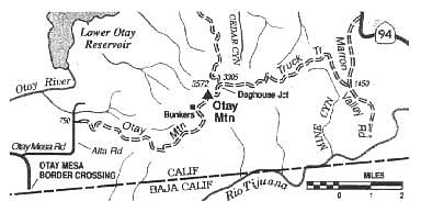
Traverse border-hugging Otay Mountain -- by truck, bike, or foot -- and chat with a Border Patrol agent.
Rising like a rumpled pillow from the eastern extremity of Otay Mesa, Otay Mountain offers unparalleled, integrated views of the bifurcated San Diego-Tijuana metropolis, the Coronado Islands, Point Loma, and San Diego Bay. Seen on a crystal-clear winter morning, the wide-ranging panorama is almost aerial in perspective and must be seen to be believed.
In December 1999, President Clinton signed legislation designating 18,500 acres of the Otay Mountain region as federally protected wilderness. The slopes are host to about two dozen rare or endangered plants, many of which are locally common but found nowhere else in the United States or in the world. The most impressive of these is the Tecate cypress, which grows in scattered stands on the north slopes.
The primary access to the mountain range is the 15-mile-long Otay Mountain Truck Trail, a graded dirt roadway slicing longitudinally through the wilderness area but not included within it. Public use of the road includes travel by foot, mountain bike, and motorized vehicle (high clearance is definitely recommended).
To reach the west-side starting point, take Interstate 905 east from either I-5 or I-805. It becomes Otay Mesa Road atop Otay Mesa. Just before the main road curves south to the Otay Mesa border crossing, turn left (continue east) on Otay Mesa Road. After 1.5 miles, turn north on Alta Road and continue 0.9 mile to an unmarked road on the right. You pass the old Kuebler Ranch buildings and continue curling up the mountain on Otay Mountain Truck Trail.
On the east side of the mountain, Otay Mountain Truck Trail intersects Marron Valley Road, 2.7 miles south of Highway 94 near Dulzura.
Whichever way you go, the scenery gets especially interesting near the 2500-foot level, where dwarf forests of Tecate cypress thrive by virtue of the extra moisture they gather from the often-soupy marine-layer clouds. You'll find the Otay Mountain summit ridge crowned with an unsightly clutter of antennas, but your line-of-sight vision in winter often stretches to the snow-capped San Gabriel, San Bernardino, and San Jacinto Mountain ranges, about 100 miles to the north. Near the road about a mile southwest of the highest summit is an old concrete structure and other circa?World War II remains. During the war, massive gun emplacements, ammunition batteries, and lookouts were established here to defend against an anticipated Japanese naval assault.
Because of its proximity to the international border, U.S. Border Patrol agents intensively monitor the area. You will almost certainly interact with a least one of them. Noncitizens are advised to bring along their passports or other appropriate documentation!
Here's something you might be interested in.
Traverse border-hugging Otay Mountain -- by truck, bike, or foot -- and chat with a Border Patrol agent.
Traverse border-hugging Otay Mountain -- by truck, bike, or foot -- and chat with a Border Patrol agent.
Rising like a rumpled pillow from the eastern extremity of Otay Mesa, Otay Mountain offers unparalleled, integrated views of the bifurcated San Diego-Tijuana metropolis, the Coronado Islands, Point Loma, and San Diego Bay. Seen on a crystal-clear winter morning, the wide-ranging panorama is almost aerial in perspective and must be seen to be believed.
In December 1999, President Clinton signed legislation designating 18,500 acres of the Otay Mountain region as federally protected wilderness. The slopes are host to about two dozen rare or endangered plants, many of which are locally common but found nowhere else in the United States or in the world. The most impressive of these is the Tecate cypress, which grows in scattered stands on the north slopes.
The primary access to the mountain range is the 15-mile-long Otay Mountain Truck Trail, a graded dirt roadway slicing longitudinally through the wilderness area but not included within it. Public use of the road includes travel by foot, mountain bike, and motorized vehicle (high clearance is definitely recommended).
To reach the west-side starting point, take Interstate 905 east from either I-5 or I-805. It becomes Otay Mesa Road atop Otay Mesa. Just before the main road curves south to the Otay Mesa border crossing, turn left (continue east) on Otay Mesa Road. After 1.5 miles, turn north on Alta Road and continue 0.9 mile to an unmarked road on the right. You pass the old Kuebler Ranch buildings and continue curling up the mountain on Otay Mountain Truck Trail.
On the east side of the mountain, Otay Mountain Truck Trail intersects Marron Valley Road, 2.7 miles south of Highway 94 near Dulzura.
Whichever way you go, the scenery gets especially interesting near the 2500-foot level, where dwarf forests of Tecate cypress thrive by virtue of the extra moisture they gather from the often-soupy marine-layer clouds. You'll find the Otay Mountain summit ridge crowned with an unsightly clutter of antennas, but your line-of-sight vision in winter often stretches to the snow-capped San Gabriel, San Bernardino, and San Jacinto Mountain ranges, about 100 miles to the north. Near the road about a mile southwest of the highest summit is an old concrete structure and other circa?World War II remains. During the war, massive gun emplacements, ammunition batteries, and lookouts were established here to defend against an anticipated Japanese naval assault.
Because of its proximity to the international border, U.S. Border Patrol agents intensively monitor the area. You will almost certainly interact with a least one of them. Noncitizens are advised to bring along their passports or other appropriate documentation!