Here's something you might be interested in.
Ask a Hipster — Advice you didn't know you needed
Big Screen — Movie commentary
Blurt — Music's inside track
Booze News — San Diego spirits
Classical Music — Immortal beauty
Classifieds — Free and easy
Cover Stories — Front-page features
Drinks All Around — Bartenders' drink recipes
Excerpts — Literary and spiritual excerpts
Feast! — Food & drink reviews
Feature Stories — Local news & stories
Fishing Report — What’s getting hooked from ship and shore
From the Archives — Spotlight on the past
Golden Dreams — Talk of the town
The Gonzo Report — Making the musical scene, or at least reporting from it
Letters — Our inbox
Movies@Home — Local movie buffs share favorites
Movie Reviews — Our critics' picks and pans
Musician Interviews — Up close with local artists
Neighborhood News from Stringers — Hyperlocal news
News Ticker — News & politics
Obermeyer — San Diego politics illustrated
Outdoors — Weekly changes in flora and fauna
Overheard in San Diego — Eavesdropping illustrated
Poetry — The old and the new
Reader Travel — Travel section built by travelers
Reading — The hunt for intellectuals
Roam-O-Rama — SoCal's best hiking/biking trails
San Diego Beer — Inside San Diego suds
SD on the QT — Almost factual news
Sheep and Goats — Places of worship
Special Issues — The best of
Street Style — San Diego streets have style
Surf Diego — Real stories from those braving the waves
Theater — On stage in San Diego this week
Tin Fork — Silver spoon alternative
Under the Radar — Matt Potter's undercover work
Unforgettable — Long-ago San Diego
Unreal Estate — San Diego's priciest pads
Your Week — Daily event picks
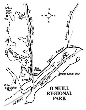
Survey Orange County's landscape from the Ocean View Point in O'Neill Regional Park.
During the 55-year existence of O'Neill Regional Park in Orange County, the park's area has grown from 278 acres to more than 3000 acres. During this same span of time, a spreading tide of suburban development has moved toward and now half-engulfs the park borders. Entirely new communities such as Mission Viejo and Rancho Santa Margarita have materialized on a rolling landscape that once supported nothing but grazing land for cattle. O'Neill Park is one of southern Orange County's key greenbelt zones that has kept the region from closely resembling the continuous, mind-numbing urban tapestry of the nearby Los Angeles Basin.
To reach O'Neill Park from Interstate 5, exit at El Toro Road and drive east seven miles to Cook's Corner (famous for its biker bar), where Live Oak Canyon Road branches right. Follow Live Oak Canyon Road south for three miles to the park entrance. A day-use fee covers use of the park between 7 a.m. and sunset. The park also has 93 camping spaces, first come, first served.
Of several possible hiking routes within the park, the most rewarding -- for an hour or two of your time, at least -- is the three-mile Ocean Vista Point loop. From the O'Neill Park entrance, walk north on the paved service road that runs parallel to Live Oak Canyon Road. Almost immediately, bear left on another paved road leading to some hilltop water tanks. After about 0.3 mile, leave the pavement and veer right onto a dirt road -- the Live Oak Trail. After swinging around two hairpin turns, go left at the next fork, staying on Live Oak Trail. This road takes you up to and then along the top of a viewful ridgeline. Your destination, a 1492-foot bump on the ridge ahead -- the Ocean Vista Point -- may be identified from afar by a spiky cellular-telephone antenna structure near its top.
Breezy days from late fall to early spring are best for expansive views from the vista point. Above the low-lying layer of fog or smog along the coastline and L.A. Basin, you can often see Santa Catalina Island, the Palos Verdes peninsula, and the Santa Monica Mountains. To the east, the mile-high Santa Ana Mountains rise impressively, more so because from this vantage point you look down upon their lower flanks, as well as up to their highest summits. On days with Santa Ana winds -- presuming there are no wildfires burning -- the crystalline air permits a fine view of the blue Pacific Ocean.
To complete the looping hike, follow the Vista Trail east (and steadily downhill) toward Live Oak Canyon. Bear right at the bottom and follow an old, mostly paved service road paralleling Live Oak Canyon Road. Continue south, slightly downhill, until you reach your starting point.
Here's something you might be interested in.
Survey Orange County's landscape from the Ocean View Point in O'Neill Regional Park.
Survey Orange County's landscape from the Ocean View Point in O'Neill Regional Park.
During the 55-year existence of O'Neill Regional Park in Orange County, the park's area has grown from 278 acres to more than 3000 acres. During this same span of time, a spreading tide of suburban development has moved toward and now half-engulfs the park borders. Entirely new communities such as Mission Viejo and Rancho Santa Margarita have materialized on a rolling landscape that once supported nothing but grazing land for cattle. O'Neill Park is one of southern Orange County's key greenbelt zones that has kept the region from closely resembling the continuous, mind-numbing urban tapestry of the nearby Los Angeles Basin.
To reach O'Neill Park from Interstate 5, exit at El Toro Road and drive east seven miles to Cook's Corner (famous for its biker bar), where Live Oak Canyon Road branches right. Follow Live Oak Canyon Road south for three miles to the park entrance. A day-use fee covers use of the park between 7 a.m. and sunset. The park also has 93 camping spaces, first come, first served.
Of several possible hiking routes within the park, the most rewarding -- for an hour or two of your time, at least -- is the three-mile Ocean Vista Point loop. From the O'Neill Park entrance, walk north on the paved service road that runs parallel to Live Oak Canyon Road. Almost immediately, bear left on another paved road leading to some hilltop water tanks. After about 0.3 mile, leave the pavement and veer right onto a dirt road -- the Live Oak Trail. After swinging around two hairpin turns, go left at the next fork, staying on Live Oak Trail. This road takes you up to and then along the top of a viewful ridgeline. Your destination, a 1492-foot bump on the ridge ahead -- the Ocean Vista Point -- may be identified from afar by a spiky cellular-telephone antenna structure near its top.
Breezy days from late fall to early spring are best for expansive views from the vista point. Above the low-lying layer of fog or smog along the coastline and L.A. Basin, you can often see Santa Catalina Island, the Palos Verdes peninsula, and the Santa Monica Mountains. To the east, the mile-high Santa Ana Mountains rise impressively, more so because from this vantage point you look down upon their lower flanks, as well as up to their highest summits. On days with Santa Ana winds -- presuming there are no wildfires burning -- the crystalline air permits a fine view of the blue Pacific Ocean.
To complete the looping hike, follow the Vista Trail east (and steadily downhill) toward Live Oak Canyon. Bear right at the bottom and follow an old, mostly paved service road paralleling Live Oak Canyon Road. Continue south, slightly downhill, until you reach your starting point.