Here's something you might be interested in.
Ask a Hipster — Advice you didn't know you needed
Big Screen — Movie commentary
Blurt — Music's inside track
Booze News — San Diego spirits
Classical Music — Immortal beauty
Classifieds — Free and easy
Cover Stories — Front-page features
Drinks All Around — Bartenders' drink recipes
Excerpts — Literary and spiritual excerpts
Feast! — Food & drink reviews
Feature Stories — Local news & stories
Fishing Report — What’s getting hooked from ship and shore
From the Archives — Spotlight on the past
Golden Dreams — Talk of the town
The Gonzo Report — Making the musical scene, or at least reporting from it
Letters — Our inbox
Movies@Home — Local movie buffs share favorites
Movie Reviews — Our critics' picks and pans
Musician Interviews — Up close with local artists
Neighborhood News from Stringers — Hyperlocal news
News Ticker — News & politics
Obermeyer — San Diego politics illustrated
Outdoors — Weekly changes in flora and fauna
Overheard in San Diego — Eavesdropping illustrated
Poetry — The old and the new
Reader Travel — Travel section built by travelers
Reading — The hunt for intellectuals
Roam-O-Rama — SoCal's best hiking/biking trails
San Diego Beer — Inside San Diego suds
SD on the QT — Almost factual news
Sheep and Goats — Places of worship
Special Issues — The best of
Street Style — San Diego streets have style
Surf Diego — Real stories from those braving the waves
Theater — On stage in San Diego this week
Tin Fork — Silver spoon alternative
Under the Radar — Matt Potter's undercover work
Unforgettable — Long-ago San Diego
Unreal Estate — San Diego's priciest pads
Your Week — Daily event picks
Life Along the San Diego River
Mission Valley before the concrete - farms and dairies of the Gugllemettis, Fentons, Ferraris, Levis, McReadys, Ohres
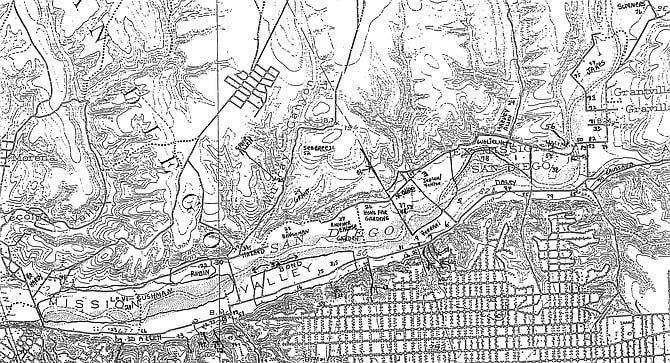
Mission Valley map explained by Fritz Ohre. “Then there was Scott (No.14). There were chickens there, and I used to go over there. He had a daughter, Christine, that I used to see, and her father said to me, ‘What are you doing over here? You’re too young to see my daughter.’"
Mission Valley is a distinctive place. In the midst of the mesa or plateau that is San Diego lies a canyon six miles long, 500 feet deep, and 2000 feet wide. Arthur Ribbel, in an April 30, 1972, article in the San Diego Union, described an earlier Mission Valley.“Oldtimers, many years ago, looked down upon a vastly different Mission Valley than they do today, a garden-land then of small farms and dairies, rather than a center of commerce pouring rich dollar-blood into San Diego’s economy.
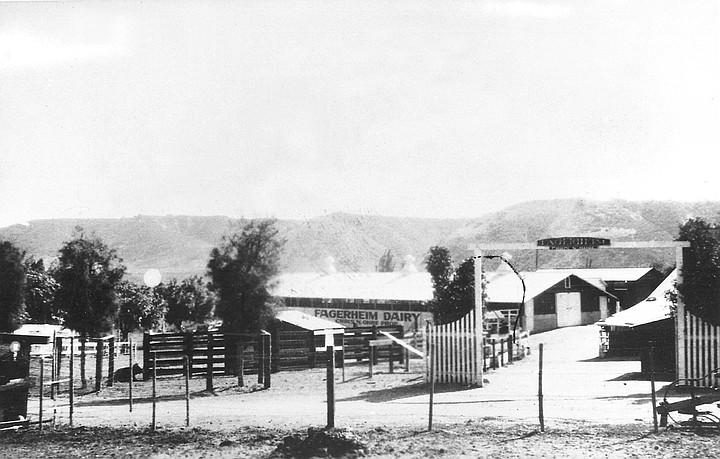
Fagerheim Dairy, 1927. "Fagerheim was a place where my father went to school — somewhere in Norway. The house was set back from Friars Road, and there were four barns in front of it. One was built adjacent to Friars Road. To the east of the house was the Fenton property. Friars Road was the first road in California.”
“Drifting into nostalgia, they see, instead of motels, business houses, restaurants, hotels, a golf course and hurry-up traffic, a tranquil and beautiful checkerboard of well-manicured farm fields planted in alfalfa, corn, cabbage, beans, squash, and other produce. They see peaceful dairies and the San Diego River, bubbling up here and there from its upside down position beneath the sand in summer. A green isle in memory… that natural play land of Boyville, maybe deep within virginal thickets of willow along the river.…
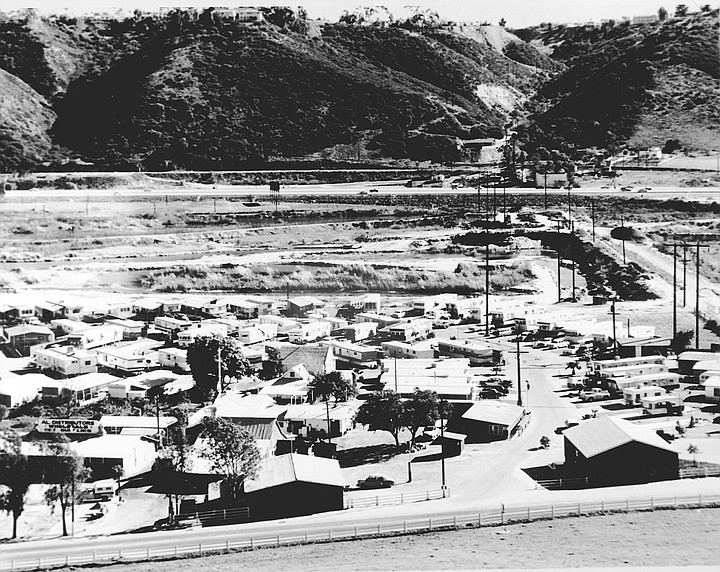
Ohre mobile home park, Mission Valley, 1975. "After we closed the dairy, we decided to start a mobile-home park. Dr. Askew who was opposed to mobile-home parks because of typhoid. I went to Dr. Askew and said that any time the authorities had asked the Ohre family to comply with milk regulations, they had done so."
“And, contrary to the detractors of the San Diego as a river, fish, bluegill, sunfish, could be caught in some pot holes where they took up residence after they tumbled over the Cuyamaca Dam spillway in the mountains, or through the outlet of the dam. Then they went down Boulder Creek to the diverting dam, worked up the river into the gorge below Julian and downstream to the lower reaches of Mission Valley.…
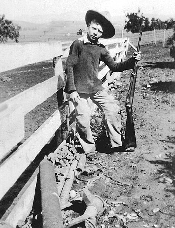
Fritz Ohre, c. 1920. Ohre was born in 1910, lived in Mission Valley until the mid-1980s, and identified the numbered places on the map at top of this story.
“Japanese truck farmers hunkered solicitously over plants, giving each meticulous, individual attention. Some of the produce would be hauled to the Farmers’ Market in downtown San Diego, where the city folks would gather on certain days to replenish their coolers, and their news of the town. How fresh was the air, and how fragrant were some of the unfertilized fields in that verdant valley.…
“There were no flood control works, no great edifices, little paving, no El Capitan or San Vicente dams to stay the torrents of the river, no sports stadium, no mass migration of settlers, and the downtown, about four or five miles ‘that-a-way,’ seemed far distant.
“Shooting stars, lupin, violets and other wildflowers prettied some of the slopes and flats.”
Mission Valley was discovered by Europeans in 1769, when members of Father Junípero Serra’s colonizing expedition arrived in San Diego. As Richard Pourade writes in The Explorers, “The first task…was to find a good source of fresh water.…
“They walked for about three leagues till they came to the banks of a river lined on both sides with overspreading cottonwoods of heavy foliage.… In the grove there was a variety of shrubs and sweet-smelling plants, such as rosemary, sage, Castilian rose, and above all, an abundance of wild grape-vines, which at that time were in flower.”
Nan Taylor Papageorge, in her spring 1971 Journal of San Diego History article entitled “The Role of the San Diego River in the Development of Mission Valley,” takes up the story from there. “When the group that had arrived by ship was joined by the land party of Fr. Junípero Serra, they moved their camp up to a bluff overlooking the river (both for safety and to be nearer the source of water) and on July 16, 1769 founded the Mission and military post that was known as the Presidio.
“The first year they planted their crops near the river, and the river rose so high that it carried away all that was sown. The second year planting was done further back from the stream, but the water was so scarce that most of the plants died.
“The padres recommended that the Mission be moved further up the Valley in hopes of having better luck with the crops. Fr. Serra in his first report of the Mission for 1774 stated, ‘It is determined to move the Mission within the same canada of the port toward the northeast of the presidio, at a distance of a little less than two leagues. The place is much more suitable for a population, on account of the facility of obtaining the necessary water, and on account of the vicinity of good land for cultivation. The place is called Nipoguay.’ The move was accomplished in August of 1774 and Mission Valley had its first white inhabitants and California’s first mission had its permanent home.…
“The Spanish Military forces remained at the Presidio. According to British Captain George Vancouver who visited there in 1794,the military were supported by the fields and labors of the missionaries and their Indian neophytes. Thus Mission Valley supported both settlements.
“The marvel of the mission era was the dam and aqueduct which was started in 1807. Using Indian labor, they dammed the San Diego River at the head of Mission Gorge where the river ran the year round. An aqueduct was run nearly six miles through a rugged canyon to the fields of the mission. The padres didn’t keep many records during this time but Frs. Sanchey and Martin reported in 1813,‘We are working on an aqueduct, which is to bring water to the Mission.’ In 1814 they reported that 3.8 miles had been completed.… With the advent of the water Mission agriculture flourished. Vineyards, orchards and crops were quite successful, as were herds of cattle. When the Mission was secularized in 1833, the inventories show that it was a thriving enterprise.
“Don Blas Aquilar, an old time resident of San Diego, recalled that by 1821 there were 15 rancherias and two vineyards in Mission Valley. He said that all the crops were washed away and homes were damaged by a great flood that year, and the river changed its course back into False Bay [Mission Bay].
“A tiny town slowly grew up at the foot of Presidio hill.…
“The townspeople planted their gardens in nearby Mission Valley, and obtained their water from the river or from under its sands.…” The Spanish-American War brought rapid changes to San Diego. Papageorge writes: “In 1846, as the Americans were about to take over, Pio Pico gave a deed of sale to Don Santiago Arguello for ‘the remaining lands unsold’ of the Mission San Diego. A new era was about to begin. The Spanish had discovered the San Diego River and Mission Valley and though peopled sparsely, the valley was used for agriculture and cattle raising. After the first few years of adequate rainfall, the valley suffered under a long dry spell until the 1820s and 30s brought more rain and several floods. The Mission, once the center of culture in the valley, was falling into ruins.
“After three hundred years of Spanish rule, and twenty-four years under the Mexican flag, the Pueblo of San Diego and all of California 48 was ceded to the United States for $15,000,000,in 1848. Captain S.F. du Pont, U.S.N., of the U.S.S. Cyane took the port of San Diego and his officer, Lt. Rowan, raised the American flag over the plaza of Old Town on July 29, 1846. Du Pont later viewed the dilapidated mission and the remains of its gardens and vineyards, remarking that, ‘A more miserable and naked sight I never saw.’ ”
During the war, the priests left the mission and American troops occupied it. Historian James Nolan was interested in what happened to the mission’s paintings and artwork. In his book Discovery of the Lost Art Treasures of California’s First Mission, he writes: “San Diego’s art treasures…were not destroyed heedlessly either by the Spanish or American residents of San Diego, nor were the statues used for target practice as was said to have happened at other missions. They were cautiously removed from the Mission Church in the year 1848, as is testified to by an inventory made of the movable goods at the Mission in that year, at a time when those works of art were still in a good state of preservation. This fact is confirmed by Philip Crosthwaite, who upon leasing the mission from Colonel J. D. Stevenson in October of 1848, ‘removed there with his family to the priest’s house’ and reported in that year that ‘with few exceptions the old rooms, offices, and workshops were then in good order.… He found there many trunks full of priests’ clothing. There were rich vestments, chalices, and various church furniture, some good oil paintings in the church.’ In 1849, Crosthwaite reported, all of these invaluable treasures had been removed.…
“All evidence, direct and indirect, suggests, then, that the vestments, chalices, candlesticks, and other valuables of the Mission Church including its art, were not lost but carefully transferred to the Estudillo House [in Old Town]. Therefore, it is not in the least surprising to discover in September of 1851 the first well-known public ceremony of a religious nature in Old Town— involving the use of richly laden vestments obviously from the Mission — emanating from that important mansion located at the east end of the plaza, an entourage coming from the Estudillo House intent upon the formal laying of a cornerstone for this tiny community’s first church.” One can only imagine the strange procession of horses and wagons that had transported the treasures from the mission to Old Town several years earlier.
“In 1850,”Papageorge writes, “New Town was laid out by William Heath Davis closer to the port. But water for the ships and for the new community still had to be hauled from the river. The population, according to the first census of 1850, was six hundred and fifty.…
“The first government action to imply that the San Diego river stood in need of curbing was the U.S. Coast Survey whose report of 1851 by A.D. Bache warned that the bay may be destroyed by the silting action of the river.… Thus, Lt. George Horatio Derby, of the U. S. Army Corps of Engineers, was sent to San Diego in 1853 to build what was to become known as Derby’s Dike.…
“A painting shows Derby’s Dike in 1853 and in Mission Valley beyond, there are a few farms outlined in trees, and a large undeveloped area. Two years of heavy rainfall preceded 1855 when 12.7 inches of rain added up to the flood that washed out Derby’s Dike.…
“The great flood of 1862 is said to have been the largest in volume. (Precipitation was 15.75 inches that year.) The vast flat between Old Town and False Bay was covered. Houses were swept out to sea; gardens, olive orchards, and a grove of trees thirty feet high were washed away. Capt. Sherman lost his horses trying to cross the stream and a Capt. Johnson was unable to get across to his home for two days. Although apparently the volume of water was vast, there was no terrible loss of property. San Diego was only a town of about seven hundred and fifty people, and Mission Valley was still sparsely settled.
“Although a few wells were in use in the town, Mission Valley was still the principal source of water. It was known to old-timer Stephen Peters as Agua de la Communidad and was for general use as were the community grazing lands. The water was obtained in dry season by sinking boxes or barrels into the sandy river bed. Water was carted up to the Hotel in town and cost twenty-five cents a bucket.
“In the 1860s, a road crossed the river at Old Town and went up the north side of the river to the mission. One early resident of San Diego remembers that there were several houses on the north side of the river. One man had his house and garden in the river bed and people tried to tell him he would be washed away. He would not believe them, but woke up one morning in the flood of 1867 and found that he and his house were floating down to the bay.…”
In 1868, Philip Crosthwaite built an adobe house. As Thomas Adema states in his thesis entitled “San Diego’s Oldest Pioneer, Philip Crosthwaite, 1825–1903,” “The Crosthwaites often held dances and parties on their ranch in Mission Valley.…
“As was the tradition in the Spanish families, Philip Crosthwaite held a large celebration for his daughter Josefa’s eighteenth birthday in early March 1872. Like his other daughters, Josefa Crosthwaite was known throughout San Diego for her charming personality and beautiful appearance. The Spanish style fiesta, with music, dance and spirits, continued throughout the night and ended at about three o’clock in the morning.
“A month after the celebration on the ranch, a fire raged through San Diego [Old Town] delivering the knockout punch to the town. From then on Old San Diego would slowly decay and the area known as New Town would take complete control of the economy in the surrounding area.… In January 1874, a year and a half after the fire, a terrible flood swept down Mission Valley and all of the land from one side of the valley to the other was under water. This forced Crosthwaite to abandon his adobe and find higher ground. The flood destroyed most of the improvements which Crosthwaite had made to his ranch and also hit several structures on the somewhat elevated town of San Diego. It swept away sections of the old adobe home of Crosthwaite’s father-in law Bonifacio Lopez, located at the base of Presidio Hill.”
In 1872, a county hospital and poor farm were started in the valley where today State Route 163 goes up the south rim to Hillcrest. In a report entitled “First Annual Report of the San Diego County Hospital and Poor Farm to the Board of Supervisors for the Year Ending June 30, 1889,” a floor plan and history of the facility are presented. The history stated, “This Hospital was established July 1, 1872, and up to June 30,1889, has accommodated 1,237 patients.
“It is located three and one-half miles from the City of San Diego, at the foot of the grade leading to Mission Valley, about midway between Old San Diego and the old Spanish Mission. The grounds and farm cover an area of 140 acres.
“The Hospital is capable of accommodating about 60 patients. A plan is now being considered by the Board of Supervisors for the construction of several additional cottages for the accommodation of sick and indigent families.…
“[The superintendent’s] office is supplied with telephonic connection with San Diego and surrounding towns.…
“The farm is provided with two first-class windmills, chicken houses and general outbuildings.…
“On this farm there are four acres of orchard under cultivation, producing figs, apricots and peaches; and having a few orange trees not yet bearing.
“There are also about four acres of garden, producing vegetables enough to supply present demand.”
A partial list of conditions for which people were treated includes abscess, apoplexy, arthritis, anemia, bronchitis, contusion, cardiac disease, cirrhosis, conjunctivitis, alcoholism, dysentery, and burns. Amputations were performed. The County Hospital, after a time, was moved up the hill, and the poor farm, later known as Edgemoor Farms, was relocated to Santee. The Mission Valley site was taken over by Mountain Meadow Dairy.
C.W. Sandrock’s Tienda, at the foot of what is now the Texas Street grade, sold provisions primarily to the Mexican families who owned small rancherias in Mission Valley. A one-story building, the store consisted of five rooms: the store proper, a front room, two side rooms, and a bedroom. Clemens Sandrock, the store’s owner, was of Prussian ancestry. He had moved to Mission Valley with his German wife, Anne Doescher Sandrock, by 1878. By 1892, he had set up a second store in Old Town.
In 1895, Anne Sandrock was murdered in the store. She had separated from her husband, who was living with their younger children in Old Town. An inquest was held, and the motive was felt to be robbery, as money from Mrs. Sandrock’s purse was missing.
Eugene Skinner, in an interview conducted by Edgar F. Hastings on March 24, 1959 (San Diego Historical Society Oral History Collection), recalled the incident. “I faintly remember the Sandrock murder. I was a little fellow, and I remember my father taking me out there that next morning. It was a little store on the west side of the Texas Street grade, about 200 feet from where the speedway is today, on the left hand side as you go down. It was a little grocery store, and Mrs. Sandrock, as I remember it, was murdered there by an Indian that came down the valley that night. Something happened and she was murdered.
“I remember the location of the store at the foot of (I think that was called Sandrock Grade), now Texas Street. It was just about two or three hundred (feet) this side of what is now Camino Real — a little, one-story, small grocery store. I remember him taking me out there and we saw it, and that was all.”
Only a few people lived in Mission Valley in 1895. George Veasey and Henry Frank lived near the Sandrock store, and Indians lived at Miguel’s Rancheria, one or two miles away. There were several other households in the valley.
After the Sandrocks arrived, others came who were still there into the 20th Century. Around 1884, Sereno and Phemie Allen and their children moved to San Diego. As daughter Gertrude Eudora Allen recalled in an interview conducted by Edgar F. Hastings on September 15,1959 (San Diego Historical Society Oral History Collection),her father “…arranged to buy the place in Mission Rancho in Mission Valley about a mile above Old Town. It was the old Crosthwaite place. That historic old adobe house (was on it then) and it had been abandoned by the Crosthwaite family and the walls were boarded up and the old barns were a wreck, but he thought that was the best possibility.…
“It was arranged to have somebody clean the old adobe house out and to take the family directly there. I can remember the horse and wagon met the train. We stopped at the grocery on the Plaza in Old Town and got some groceries and went directly to this house— of course we kept the necessary equipment to make a home.
“My father was interested in farming. He was an agriculturalist. He had a good deal to do to develop. There was no water and he started by building the windmill and the well down at the river to pump the water up to the house and getting a team of horses and the necessary things to run the farm. He saw that there was a future in farming when the Panama Canal was built. He wanted to have a lemon orchard.
“He started by farming the ground. Of course it was a rather tough going. It was sandy soil. He had a hundred and sixty acres there. He owned down by the Bernards Nursery and up on the hill, where Allen Terrace is, and that bench ground. Clear from the top of the hill — clear up Mission Hills — down into the river bottom.” A remnant of the old, abandoned Allen Dairy Road, used by the family to deliver dairy products to Mission Hills and other parts of San Diego, endures today as Allen Road.
People also settled at the east end of the valley. Grantville was established in 1887 as a haven for Civil War veterans but fell victim to San Diego’s economic bust of the 1890s.
“At the turn of the century,” Papageorge writes, “San Diego was a growing city of 17,700 whose interests were elsewhere than in Mission Valley. ‘It’s only Mission Valley,’ quoted one oldtimer who complained of the marshes and mosquitoes.… To view the rural scene from above was, however, a favorite pastime of San Diegans who visited Mission Cliff Gardens at the foot of the trolley line on Park Avenue. The beautifully kept grounds opened onto a vista below of the river meandering through small groves and farms. A gazebo was perched on the rim of the cliff. This was also a favorite spot to watch the rampaging river during flood years.
“Some concern was felt for the problem of flooding.…
“The first large flood of the twentieth century was in the winter of 1905–06 after a very wet year in 1905. The embankment at the end of Old Town bridge washed out, the channel shifted to the north, and the river ran until late in the summer.”
Sometime in the early 1900s, the county planned a new hospital in Mission Valley for people with tuberculosis, syphilis, and other infectious diseases. Isolation Hospital, also known as Detention Hospital or Women’s Detention Hospital, was built just below where UCSD Medical Center is today.
One business essential to the growth and development of San Diego was the sand and gravel industry. Buildings were made of concrete, which is mostly sand and gravel, and these constituents also went into the manufacture of asphalt. Sand and gravel were mined in Mission Valley by the Hazard, Daley, and Fenton interests. Fenton purchased land near where the stadium is now. The Daley asphalt plant was located at the foot of Ward Road, and the Hazard plant was located where Hazard Center is today, near State Route 163.
From 1900 to the mid-1950s, the primary occupations in Mission Valley were farming, vegetable growing, dairying, and the supplying of sand and gravel.
The story of the Ohre family is typical for this period. On October 24,1995, I conducted an oral history interview of Mr. Fritz Ohre, parts of which follow.
Mr. Ohre was born in 1910 and lived in Mission Valley until the mid-1980s. He was asked to show on a map who lived where in Mission Valley from approximately 1920 to 1950, starting at the east end of the valley and moving west. Some of the locations he discussed are numbered in the text below. The numbers correspond to positions on the map found at top of this story.
Mr. Ohre begins, “Well, the first family that lived along there, I would probably say, was the Guglielmettis (No. 1).
“Then we have Jepson. He lived across the valley (No.2), but he had 140 acres (No.3) adjacent to our property (No.4). He picked rocks off his property during the summer. They weren’t used — they were just in the way. I was just ten years old and I recollect that Jepson wanted to sell that property to my father for $15,000. It was 140 acres. It’s next to Friars Road. My dad didn’t want to buy it. He said that he could keep the five brothers busy on the 60 acres. He didn’t want us over there picking rocks. Anyway, that was a very false reading because we wouldn’t have had to pick any rocks. We would have just had to make ends meet on that property, and it would have been of terrific value later on.”
“Wasn’t Fenton the one that bought it?”
“Yeah. He first raised beans on there, and then it became a rock plant. The rocks were mined in the canyon and along with sand from the river were used to make concrete. Henry G. Fenton married a woman whose family owned Western Salt Works.
“And now we’re going to get into an area where my father bought Lot 33 and half of Lot 34, which was part of the Ex Mission Rancho. A man named Hoff also owned part of Lot 34 at one time. Lot 34 is an interesting piece of information. There was a eucalyptus grove in there and a Mr. Peck who lived uptown came in and cut down the eucalyptus trees to make utility poles, which weren’t too good for that purpose because they would rot and split. Later we would cut the trees and sell them to our milk customers as cordwood.
“Our lot went to the middle of the river and to the top of the hill, just to the crest of the hill. The Jepson/Fenton place went on both sides of the river.
“South of Guglielmetti was Gibson (No.5). He lived across the valley. A little bit west of Guglielmetti there was two Phoenix palm trees there and a building, and I don’t know what he done. He lived up on a point on top of the hill in a sharp gabled house and built a small building down in the valley on the south side of the road there. I don’t know what he used it for.
“Next to Gibson was McDermott (No.6). I don’t know what he did for a living. McDermott was between Ferrari (No.7) and Gibson.
“Ferrari grew vegetables, however, and later had a dairy. And west of Ferrari was Ricard (No.8). He was a vegetable farmer and he was married to a woman who was a large portion Indian. He made wine and also sold cheese and milk.
“And there was next a pumping station going up and down the valley, and that was run by a man named Clark (No. 9).
“In between here, they had a railroad track (No.10), and there’s a little canyon right there with a railroad track going up it where they could take the gravel and sand up from the river area by horse and wagon. They had to haul it; they didn’t have any fancy tools then.
“West of Clark was where Jepson lived, at the foot of the hill (No. 2).
“West of Jepson was Reland (No. 11), and after that was Officer (No. 12). Reland lived next to the Clark pumping station in a two-story house. I don’t know who was in there before him. He was a Finn. I don’t know what he did for a living. The Officers lived on the south side of the road in a two-story house with dirt floors. Officer was a farmer and later worked as a watchman at a well located where May Company is now [Mission Valley shopping center]. The Timkin ballbearing people drilled a well 5000 feet deep and struck oil down there, and I don’t know what quality it was, but the well was sealed off later. I don’t doubt that there was oil there. Union Oil went around and gave a percentage of it to people in the neighborhood. My father didn’t want to take part in it, but the rest of the people did.
“Sandrock store was right in here (No. 33), and then we had Sandrock grade (No. 13).
“Then there was Scott (No.14). There were chickens there, and I used to go over there every once in a while. He had a daughter, Christine, that I used to see, and her father said to me, ‘What are you doing over here?’ and then I think he said, ‘You’re too young to see my daughter.’
“Bond’s dairy was next (No.15). Bond early on was a sheepman — his thing was sheep rather than cows. He used to grow vegetables there too. Then Reed, who had a dairy, was somewhere in this area here (No. 16).”
“On Camino del Rio?”
“They would be on the other side, right about here.
“McCready was there (No. 17). They had Mountain Meadow Dairy, and that was on the old Sixth Street Extension. Prior to that, I think it was called the Edgemoor Farm there, when I was real young, and later they moved up to Santee.
“Next was another dairy in there owned by a man named Mills (No. 18). He tried to grow alfalfa, but at that time we had saltwater and that was there because we didn’t have any dams. When you put dams in, there’s seepage there, and it throws the saltwater back towards the ocean, and so later on it became the golf course. After the salt water got pushed out and they started to irrigate it, then it became fertile land again.
“I want to mention another party in there by the name of Henry Gray (No. 19). Gray had gotten into a railroad accident, so his legs were crossed, and I used to trap coyotes and took them to Henry Gray, who would tan them for a dollar and a half.
“Allen Dairy was right in here (No. 20). This was known as the Allen Grade in here (No. 37).”
“And to the north of these properties, was that the Levi property?”
“Yeah, I think that’s where Adolph Levi came in. He had that whole bit in there (No. 21). There’s still the old barn south of Friars Road where they keep golf equipment and mowers. The liquor store is across the street near Via las Cumbres. In the early years, we took cows that were no longer producing to Hardy’s Slaughter House where Levitz was, and when we went through the Levi ranch we had to open some gates, and we went right past his barn and right in between his development.
“And here (No.22) was the Highland Ranch, and that was owned for a long time by a man named Rubin. He was an officer in the Navy and obtained a pretty high rank. I think he was growing vegetables on that property and had some olive trees there.”
“Did Levi’s property go from the Sixth Street Extension all the way down to Morena Boulevard?”
“Possibly so. I didn’t know the boundaries of those places. It went across over to where the Stardust Hotel and where those facilities were.
“Bernard had a nursery near Allen Dairy. He had trees, flowers, and plants for sale there (No. 23).”
“And the Allen spread was on the south side of I-8?”
“Yeah, and I don’t know how much property they had. Harvey Allen also had quite a bit of property up here at Murphy Canyon, which later became the tank farm, and he owned a chunk of property (No. 24) near Guglielmetti. And Ernie Allen (No. 25) was in the Murray Canyon. [Murphy and Murray Canyons extend north from Mission Valley; I-15 goes through Murphy Canyon and 163 through Murray.]”
“Who owned this piece north of Bernard?”
“That would have to be the Levi-Cushman interests in there, Cushman being somehow related to the Levi family.”
“How far did the Levi property go? Did they go west of Bernard?”
“I think so. I think they went right on down to Morena bridge there, as far as I know. I guess there are maps that indicate that. Adolph Levi had a place up in Lakeside, and he was always trying to sell my dad some cows. And he being Jewish and my dad being a Norwegian and they were pretty good friends, Dad said, ‘The day that you sell me a cow, we will no longer be friends.’ So, anyway that’s the way it was. But Adolph Levi would always stop by and they would shoot the breeze.”
“Now, let’s go from your place west on the north side of the river.”
“Okay, west of us was the Hong Far gardens (No.26). There was another garden in here (No. 27) — I don’t know what that was called, but there was another Chinese vegetable garden in here.
“They grew all sorts of vegetables — beets, carrots, everything, up to and including the gourds that they put their tea in.”
“Who was the Chinese family that owned that?”
“Originally it was the Hong Far garden, and then later on the owner was Tom Choy.
“West of them was Baughman, another dairy, and I would say the house was on the north edge of the road (No. 28), and the dairy barn was on the south side. Their land went right in here — this was known as the Indian Canyon. I think there was a little piece in there owned by the Russell Grant family (No.29). Yeah, they had a little piece in here, and then they owned a lot of land up here. They were land poor.
“Yeah. Ha! A friend of mine went down there one time, and Russell Grant was a single person at the time, getting up in years, and anyway, he was chasing his secretary around, and he said, ‘We were only playing; there’s nothing serious about this.’ He later married this gal. He was way up in years. I always used to kid him. I said, ‘You should have done that a long time ago,’ and he said, ‘Yeah, that was one of the biggest mistakes I ever made.’
“Oh, I have to come back to one that I missed. Cliff. I don’t know just what they did. They were right there on the south side of the road (No.30) where the Hazard block plant was (No. 31). And later there was a hot plant there owned by David Ryan, where they made blacktop or tar.
“When David Ryan got flooded in 1916, he told Baughman — see, the road at that time went straight through here, and it got flooded, and it was pretty sandy, you could hardly get through there. And he told Baughman that if he took his horses up here and plowed a furrow up here that he could get his Caterpillar tractor up there and build a road up here, and that’s what happened.”
“Was that for when the floods came?”
“After the flood. We had a pretty good road in there, and when the flood came, it loaded it up with sand and you could hardly get through there. See, we only had Model Ts in those days.
“The city claimed property in this area (No. 32) for their pumping station, and I just don’t recall how far west that went.
“I recall the McCreadys [of Mountain Meadow Dairy] quite well. Mission Beach had just opened up and they had a Roamer car, and it was a long son-of-a-gun, and we used to go over to Mission Beach and we were big shots, you know. Everybody turned around and said, ‘Where did those kids get the car?’
“Our place was on a promontory about 50 or 75 feet above the valley, and a schoolteacher by the name of Ernie Lillgren, who was a principal and teacher at Roosevelt, was quite an authority on Southwest Indian locations, and he said that our property was the second-largest Indian site in Southern California, according to his findings. You could pick up many arrowheads there and metates. One Indian jawbone.
“I never found the location of any type of Indian cemetery, so it was probably down near the river area where the digging was easy, and the graves probably all washed away.”
“Were there any other good artifact areas or Indian settlement areas in the valley?”
“Well, up at the mission. Of course, that was developed later on — that’s why Friars Road came to be, and that was the earliest road in the State of California. Down in the Old Town area, I think they were digging up some older stuff down there. They’re still digging at the mission.”
“And in the Old Town area, was it on Presidio Hill, or was it down below?”
“Yeah, the Indian site was right on the lower part of Taylor Street. There were no others that I recollect. The only place that I really knew was where we lived. And there was lots of seashells there, so evidently they went out to the ocean to pick up seafood.”
“Where were the stores in the valley?”
“The Sandrock store was the only one at that time in Mission Valley. Where we delivered milk was at 4th and University. There was a Heller store, and most of the things that you bought were in bulk: potatoes by the sack, sugar by the sack, or you scooped up the sugar and beans in a brown bag. Later on, there were other stores in the valley. There was a Ben Gibbs store. There was a good store there in Point Loma on Rosecrans. They had a store in Mission Valley too, but that was after 1940.”
“Where was Isolation Hospital?”
“It was across the valley and west (No.34). There was a stairway coming down to that Isolation Hospital (No. 35), and later Isolation Hospital was moved over to Gaines Street.”
“Do you know why it moved?”
“Well, I guess they didn’t like the whores being treated close to Mission Hills.”
“Didn’t they have patients with infectious diseases there too?”
“Yeah, I guess they had gonorrhea and all the stuff that goes along with that, syphilis. They would pick them up and that’s where they went.”
“Any other hospitals in Mission Valley?”
“No. There was the old St. Joseph’s Hospital — now Mercy Hospital.”
“Was that a Catholic hospital?”
“Yes. In those days, when you were sick it didn’t make much difference where you went.”
“The Ferraris were Catholic. Where did they go to church?”
“They went to the mission.”
“What about Lutherans or Protestants or any others, did they go anywhere?”
“Well, on occasion, I was seen at the mission, and the Catholic Sisters used to come down to our place for contributions. Later on, there was a church developed up in Grantville. I don’t recall the type of church. The minister up there was a mean son of a buck. He had a bull up there, and he would beat the hell out of that bull. I don’t know why he did it. He was kind of a two-faced person.”
“Were there any cemeteries in Mission Valley?”
“Well, Father Jayme was buried down on the mission property. They moved the body later on, and you can go up there and see where his remains are now. There are no other cemeteries in Mission Valley that I know of.”
“Where were people who were not Catholic buried?”
“Mount Hope. And if you were a Catholic, you went to the Catholic cemetery.”
“Do you remember the poor house at the bottom of the Sixth Street Extension?”
“The poor farm moved out and went up to Santee, and they were located at this part (No.17), and then I guess Mountain Meadow Dairy came in there and replaced the poor farm.
“One person that I knew quite well who I think was of Dutch descent had a little place up on the mesa north of our place. At one time, he had some heifer calves, but he just bottomed out. Anyway, when he became too old, he had a savings of about $1500, and since it cost about that much to go to the poor farm, when he went there, they took every cent he had. It was run by the county. There was quite a few people there. I think it was a one-story building.”
“Were most of the houses in Mission Valley one story?”
“No, there was a fellow with a two-story house whose name was Gates and he lived in Grantville. Bond’s house was two-story.”
“Did the Ferraris have a two-story?”
“No. We had a two-story. The Ricards had kind of a square house, and that was two story.”
“Did you have trails up the south side of the valley?”
“Well, we had one up to Adams Avenue and to Mission Cliff Gardens. They had an ostrich farm up there, and then there was the streetcar barn. My brother used to get behind these ostriches, and he would try to get on them to ride them, and they would buck him and peck at him and run around.
“Ferrari had another one that they would use.”
“So they had a trail right up behind their hill?”
“Yes.”
“Any other ponds or trails?”
“There’s an old road and a pond in here called Turtle Pond, in Alvarado Canyon near Adobe Falls.”
“And were there swimming holes up there?”
“Yeah, there were in two different places. The girls would have one and the boys would sneak up there, and the girls would be swimming nude and we would try to swipe their clothes. I used to go up there and ride horses on my way to school. At times, my horse used to take off and I would yell and scream.”
“I want to ask you about your family. What was your father’s full name?”
“Chris Nels Ohre. He was born in Tonsberg, a seaport town in Norway. I guess ‘Ohre’ is an old Viking name. There’s a river running over to Russia called the Ohre River, and, anyway, they conclude that there was a merchant route that went into Russia. My mother’s name was Mathilda, and I think her last name was Olson. She was born in Gottenburg, Sweden. They were married in San Diego.
“My father was a captain of a sailing ship, and up in Descanso I have a book naming the ships that he was captain of.” “Did they meet in San Diego?” “Yes. My mother came over here and got very seasick because it was rough weather across the Atlantic.”
“Did they come through New York?”
“Yes. My father worked on the railroad in New York, and there were people standing in line waiting for work, and if somebody paused and got tired and wanted to rest, they were out.
“I guess my father came to this country in the early 1880s. He went to Minneapolis and got a job with Minneapolis Moline. They had all this inventory and they didn’t know what they had in stock, so my dad organized the inventory, vouchers, ledgers. Anyway, later they told my dad that he no longer had a job there, and someone asked him if he could see the ledgers and my dad said that he had organized the ledgers and vouchers sort of on his own time, and he said he was taking them with him.
“He came to San Diego in about 1897 or 1898,and he worked for Klauber Wangenheim for some time. I don’t know what my dad did at Klauber Wangenheim. I imagine he did anything that needed to be done. My dad was pretty versatile.
“My mother I think arrived around the same time. She worked for a family, a Reverend Osburn. I can’t remember what church. I think it was the Episcopal church somewhere in Uptown. Mother came out here with a girlfriend, and the girlfriend later married someone and moved to Descanso. Dad came for the sunshine. My dad said that San Diego had the nicest climate of any place he had been.
“Dad was doing this work for Klauber Wangenheim and they started to expand the poultry to the end of Eighth Street, near St. Joseph’s Hospital. So my parents, after they were married, moved to the end of Eighth Street and lived in a one-story house.”
Five boys were born to them: Enoch Mauritz; Clarence, who died at 35 of a blood clot; Oscar Christopher; Albert; and Fritz.
“I was baptized at the Park Boulevard Lutheran Church. One time later, I decided to go to the mission to be baptized, because I thought that it couldn’t hurt, and my wife said, ‘You’ve already been baptized, you can’t go there,’ and I said, ‘Why not?’ But she stopped me in my tracks.
“When one of my brothers was born, Mother for some reason was having a hard time breast-feeding him properly, and so she told Dad if he got a cow, she knew how to milk dairy cows. So in about a week, she looked out and saw a cow, and it was a Jersey cow.
“Well, first the cow started slowing down her milk production, and we found out they should have bred her, and so we got a second cow. We started selling milk, and Mother was making butter, and Dad kept good books on them, and we got some chickens. We were making pretty good money at this, and that was when we decided to start Fagerheim Dairy. Fagerheim was a place where my father went to school — somewhere in Norway is a place called Fagerheim.”
“So, for back taxes, your parents bought the property in Mission Valley?”
“Yes. I think it was for $750. I can’t think of who lived there before. There was a ranch house and an old barn. They had hogs in that old barn for quite a while. And the house, incidentally, what do you think it was lined with? Burlap. Green burlap. I guess that was the cheapest thing they could use. They didn’t have these fancy things until later on.
“We replaced the burlap with beaver board, a pressed paper with 1½-inch slats covering the seam, which we later varnished. The house was built on the ground. It had wooden blocks under it. It was one story with a balcony up on top. That house stood all through the years on the blocks of wood, and when we later tore the house down, we discovered it had square nails.”
“When you walked into the house, did you walk into the kitchen?”
“We walked into the kitchen, and in the front of the house, we went into the living room. When you looked in the living room, there was all sorts of knickknacks and Kewpie dolls there that we had gotten at Mission Beach, and many things like that. The downstairs bedroom was my parents’ bedroom, and upstairs were two bedrooms, and I had a bedroom in an alcove. The kitchen was in the back and had a little porch.
‘The house was set back from Friars Road, and there were four barns in front of it. There was the first barn, and then later we had the horse barn. There were two hay barns; one was built adjacent to Friars Road.
“To the east of the house and barns was a milk house, and to the north was a reservoir or small pond. A pump and windmill were down near the river, and they pumped water up to the reservoir. To the east of the house was an open area, and then the Fenton property.
“We had a family orchard, and the outhouse was in the orchard. It was a two-seater.”
‘Was Friars a dirt road?” “Oh, yes.”
“Always called Friars?” “Yes. It was the first road in California.”
“This was all pasture-lands for the cows?”
“No, we had corn down there toward the river and alfalfa, and the rest of the land was pasture.”
“When you looked from the front door of your house to the south, what did you see?”
“Well, you could look out over this promontory.” “And that was your yard, your family area?” “Yes, and there was not much below there.
“We developed land down toward the river that washed away in the 1916 flood and again in 1927, and my dad built a couple of flood retaining walls, which helped a little bit. One was on the west edge of Lot 34. It went right in here, and Jakes Canyon was back here. Barry Jakes was an Englishman who later sold the property to Ernie Briden. The government took over part of the property in World War II, and later Ernie Briden sold the rest of it for development as a tank farm. The retaining walls were to keep the water from making a channel through here.
“On the west side was the county boundary line, and we had a well down here with a windmill that pumped up to the reservoir.” “Did the river change its course a lot?”
“Not too much, because we had a Chinese garden— I don’t know what it was called—between our property and Guglielmettis. There was clay underneath there and in the 1916 flood, it took all of their topsoil, but the clay underneath didn’t wash away. At one time there were lots of trees, but the 1916 flood took them all out with the exception of a big cottonwood at the Ferraris, which sat there for many years and eventually was taken down.
“To the west you could see Mission Cliff Gardens. There were some pictures taken from the Mission Cliff Gardens, and you could see the eucalyptus trees on our property.”
“When you looked to the west, you saw a lot of open land?”
“Yeah.”
“And when you looked to the east, did you see the mission?”
“Oh, you could always see the mission.”
“When you were a boy, what were people doing? Were they doing their farm-work every day?”
“Dairies were twice a day, and the vegetable people, they worked from morning to night.”
“Did your parents speak Norwegian at home?” “Very little. Other Scandinavian people were amazed that my mother didn’t teach us Swedish or Norwegian, and the reason was that they didn’t want us boys to have an accent. They wanted us to speak the English language as it should be spoken, without an accent.”
“The kids around your house spoke English?” “The Chinese — Tom Choy pointed around a lot because he couldn’t speak English.”
“So, most everybody spoke English by that time?” “Yeah. When I was going to school, we had an Indian girl that was going to our school, and she didn’t speak any English .She was a kind of special challenge to the teachers.”
“What animals were around?”
‘In the valley were coyotes, chipmunks, squirrels, bobcats, and fish — perch, sunfish, and bass. Lots of willow trees. There was the ordinary stuff you see. We had numerous wildflowers — violets, gourdscrew. To see what the valley looked like years ago, go to Mission Trails park and look at that area and the plants and animals around there, and you get a good idea of what Mission Valley was like.
“The soil was kind of a rich, black-brown loam. It was bare of rock However, you had other kinds of soil that was rocky, and then you had adobe and sandy soil. It was a good form for soil. If it was deficient soil, we could always put some nutrients in it.”
“Was the river shallow or deep right below your house?”
“It was relatively shallow. There were ponds. We had two natural ponds that people fished in — the one down by Harvey Allen, and there was one at the foot of Fairmount.
“We were warned that sometimes in the river there was quicksand, and when you got into that you just laid down and you flattened out and come back in. I think there might have been horses caught in it, and I don’t know if they got all of them out And later on, that reservoir that we had, my mother would let me go up there swimming, but she could see me from the kitchen window. Early on, I was a very good swimmer.”
“The roads at the time were Friars Road on the north side of the valley and Mission Valley Road on the south side?”
“Yes. There was a section of Friars Road between our property and the Fenton property that had a little detour in it. My dad and Fenton between themselves elected to run this road straight across, and Fenton had the equipment, and that*s what they did. I always thought the road would always settle, but it didn’t.” “Who attended Grantville School then?”
“Oh, Joe Ferrari. Lizzi Ferrari. Hilkowitz, there was a girl and a boy. Hilkowitz (No. 38) grew vegetables and owned a place on the approach to Mission Gorge near the V. R. Dennis Construction. Dennis sold crushed rock and also had a hot plant there. The school boundaries went from Grantville west to about where the 805 bridge crosses the valley now. West of that, the kids went to Florence.
“Joe Guglielmctti went to Grantville School for a while, and then he went to St. Augustine. There were Scgawas, the Tanakas. There was an Amador family down on the Harvey Allen ranch in Murphy Canyon, which included a Serafin; then Anita, and Lupe. One of the girls was really black and we called her ‘black Amelia,’ and then there was another Amelia. Then the Jaussauds (No. 39). I guess I haven’t mentioned them. They owned a dairy, and there was also a Teisseire dairy (No. 40).
“When Grantville School was first built it was up on blocks. The Grantville School that I went to had a picket fence, some rings on chains, three swings, and a T-bar. The grades in this school were 1-8. My first teacher at this school was a Mrs. Weber. The second teacher was a Miss Murphy, who lived at Seventh and University. Then, we had a teacher that weighed a lot, and we tormented her a great deal. Then, there was a Mrs. Arnold.”
“How many children did you have?”
“We had three daughters. Pat, who worked at SDG&E, and who now lives in Maine. Then, Lois, who worked for the airlines and now lives in San Diego and Descanso. And Karen, who worked at a restaurant. Karen died of cancer at about age 50. She was a smoker.” “How did you meet your wife?”
“Joe Ferrari and I were buddies, and we would go to dances at Grantville School. There was a boy from the Gates family who used to play the drum at these events. Joe Ferrari was courting Bertie Holmrud at that time. At any rate, one night, I met a girl at the school dance named Jean Crane.
“Her family was from Coffeyville, Kansas. Her mother remarried, and mother ran a restaurant on Fairmount and University. Her father remained in Coffeyville, Kansas, and ran a gas plant there. Jean lived about three blocks south of the restaurant, on 45th Street, and went to Hoover. We were married in 1934.I personally felt that I wanted to find someone who was not from the valley, or there would just be more discussion about farming, and so on. And so, I was more interested in finding someone who was not from the valley.
“We lived in Mission Valley near my parents’ house. Through the years, the Ohre family went through phases of farming. First we had corn, and then alfalfa, and oats, and later we used the land for permanent pasture. We had a variety of grasses on the permanent pasture and irrigated the pasture with pipes. We also sold the wood from the eucalyptus grove. We stopped growing corrn because it was hard to cut it. We had to cut it by hand and then had to haul it. The corn grew real high, and it was a difficult crop to harvest.”
“Fagerheim Dairy started in 1910 with Jersey cows?”
“When we lived up on Eighth Avenue, my father looked for the first cow nearby in the city, because there were many families who owned at least one cow. Then he bought another one. In our peak year we owned about 150 head. Jerseys were not a predominant breed in San Diego. The nearest place where there were Jerseys was up in Sacramento. I do recall that Jerseys gave rich milk.
“First we sold raw milk. Many dairies advertised raw milk at that time. Later, when we no longer could sell raw milk, we sold milk that was pasteurized and homogenized. We had milk routes up in North Park and Mission Hills. We first delivered milk with wagons, and later used Model T cars. The brothers split the routes up. I was the backup for the North Park route.
“The first valley dairies were Guglielmetti dairy, the Jaussauds, the Ferraris, the Bonds, two dairies operated by the Allen family, also a dairy owned by the Teisseires.
“But we did have one situation. Ha! Somehow or other, what started the whole damn ruckus was the cows were vaccinated for tuberculosis, and apparently they had a bad dose of vaccine, and this took out about half the cattle in the valley. Pretty near all of the cows had lesions on their legs. They were vaccinated under the tail, and if they showed any reaction, there would be a little swelling.
“Pete Ferrari got hit hard. We got hit hard, and all of us. My dad was kind of suspicious of our remaining cattle, and we ran short on milk. Dad heard of some Jerseys at San Pasqual that were owned by a man named Judson, so we got a cow from him and she wasn’t down here too long when she got Bang’s disease and aborted, and that started another round of problems.
“We left the dairy business when the land value got too high and it became difficult to pay the taxes on the property. Feed prices was never a factor in closing the dairy. We obtained our feed from Wirtz in Yuma.
“I recall a story about the safety of milk and our family’s reputation in this area. After we closed the dairy, we decided to start a mobile-home park on our property. There was a doctor in town named Dr. Askew who was very opposed to mobile-home parks because of the threat of typhoid. Dr. Askew was threatening to make it difficult for any new mobile-home parks to be built in the city.
“So, I went to Dr. Askew and told him what we were going to do and said that any time the authorities had asked the Ohre family to comply with milk regulations in the past, they had done so without hesitation, and he fully supported any mobile-home park that would be sponsored by the Ohre family.”
“Who were the oldest people in the valley when you were a child?”
“There was a person in Grantville and that was a Couts. I think his name was Dave Couts. Couts lived a short distance north of Grantville School in an average wood house. I believe he was a member of the Couts family, and he worked in a prominent job for the county. Another person that comes to mind is a Heffelfinger, and he lived across the road from Couts.
“Then there was Barry Jakes (No. 41). There was Jakes farm over there, in the neighborhood over there. And then there was Summers who was up the other hill on the other side from there (No. 76). Summers had a plaster house and raised cows. I remember he had nice watermelon, also.”
“Who lived in Grantville?”
“They were people who probably worked for the city and the county road station that was there.
“There are still a lot of houses and businesses down there. There was a Frenchman that lived down there named Debrouf, and I remember him because the kids used to play with slingshots, and one of the boys hit this man’s horse with the slingshot, and the horse took off. Debrouf was mad, and all hell broke loose.
“An old man named Duncan was the caretaker of the Mission, and the buildings of the mission at that time were going to rack and ruin. The front walls were there, and there was a building in the back, which had an attic, and we would crawl up into the attic, and there were bats in there. The Indians at the Mission were gone by then. I guess Duncan must have been way up in his 90s. I liked to listen to him, and I guess nobody visited him, so he would tell me the stories.”
“I’ve heard that there were two tunnels at the mission, built for protection. Where were they?”
“One of them was straight down from the Mission.”
“Okay, so it was right from the front door?”
“Yes. It wound up right inside the Mission.”
“Did you ever see that tunnel?”
“I remember looking down an open well, and I could see the tunnel down in the well. I would suppose it went in to the main building.
“And the other tunnel went down this way, close to the river. It went right up to the river. It’s close to the river. There’s a pretty sheer bank there, and it was pretty overgrown. I never saw this tunnel because it was by that time covered up. I know that Father Jayme was buried there first, and then later they moved him up onto the Mission grounds. This was the one to the east, and that area right in here was steep, real steep, and if s hard to find it.”
“What was the attitude of the valley people toward people in North Park and other areas of the south rim?”
“The people up on the rim of the hill, they had indicated that they wanted to look down into beautiful Mission Valley and see these vegetable gardens and everything, and we didn’t buy it. We in the valley could have cared less because we were trying to make a living, and so if you could call that a separation...
“They could say what they wanted, but they were our customers, and they had to behave theirselves. We had them on one side and on the other.”
“Did people come through the valley when you were a boy?”
“The kids came down to the valley to play. One group of girls used to ride horses down in the valley— Judy Vandever and Alice Quinn. I remember Alice Quinn used to have a white horse with blue eyes. There was a Marian — I can’t remember her last name— anyway, she died, I think, of cancer or something like that.”
“Were there any special places in Mission Valley?”
“Well, you could go out there with the girls under the pepper tree. People just didn’t know where Mission Valley was. I would go downtown to Gould’s Hardware and people would kind of kiddingly say, ‘Where the hell is Mission Valley?’ And I would say to them, ‘To answer your question, there was a pepper tree out there where people would go at night with a girl,’ and one of the men that was there at the time just blushed. The pepper tree was between Fairmount and Ward Road.” “Were there any places where there was a spiritual feeling?”
“Well, the only place I can think of would be the mission.”
“Tell me about holidays.” “We spent Christmas at home, usually. We had Christmas things. The first Christmas tree that I remember, we went over there by Bonds. There was some cypress trees over there, and I guess my father cut some branches from this cypress tree, and he drilled holes in it, and put branches into it, and it became a nice tree.
“I remember one time with the oldest daughter, we did our New Year’s thing. There was a fence up there on the back of this perimeter here, and we got some dynamite sticks and we cut the fuses, and we cut one of the fuses too short and when it went off, it knocked me on my butt.”
“The Fourth of July?” “Mostly we just had it at home.”
“Where did the river run?”
“It came down from the hills and cut in past the Mission and then built up steam right in here, and then it took a cut and came down here, and then across here, and then took a right angle in here, and then it reached the city pumping station. It might have varied a little bit from time to time. One million years ago, the valley was deep and narrow, and every time it flooded, soil came down from the mountains and that was what you sec down there today. We have this flat canyon which consists of sand, rock. We drilled our first well at 40 feet.” “Later you went down 850 feet.”
“Yes, and you didn’t have anything until you got down deep. You had pretty good water at the surface. When we dug that deep well, the water came to the surface and it was 90 degrees, and we pumped it up the hill to our reservoir.”
“The largest, most destructive, and most famous flood of recent times,” Papageorge writes, “occurred in 1916, again following a very wet year.... The rainfall of the previous years was so distributed that there was little run off and the water in the city’s reservoirs was very low. In December of 1915, Charles Hatfield appeared before the City Council. As a ‘rainmaker,’ he said he could fill the Morena reservoir for $10,000. The city officials voted to accept his proposition and told the city attorney to draw up a contract. Hatfield did not wait, but built a platform and began shooting off chemical explosions.
“The rain began on January 16,1916, and lasted four days. The newspapers welcomed the rain as the reservoirs began to slowly fill and noted that some people were beginning to take Hatfield seriously. Mission Valley flooded, quickly wiping out the vegetable gardens and homes of the Chinese and Japanese farmers, and ten of the twelve wells used by the city. The police and Navy Militia used flat bottom boats to rescue families. The city’s Isolation Hospital in Mission Valley had to move their patients up to the second floor as the water rose. Hundreds of people flocked to Mission Cliff Gardens to watch the spectacle below....
“The sun came out for a few days, and then a second storm began to batter the city. The San Diego River rose six feet higher. Bridges along the river were washed out, although the railroad bridge was partially saved by parking train cars loaded with rocks on it, and opening up a spillway through the earth to one side. There are many tales of heroism as more people were rescued from their homes in Mission Valley. Union headlines of the 27th stated: ‘Dams holding against Great Flood as Wires go; City Water Supply All Right.’… The peak flow of the San Diego River was established at 75,000 cubic feet per second, with total physical damage at $565,000. All important highway and railroad bridges were destroyed or severely damaged, many miles of roadbeds and tracks were washed out, and telephones and telegraph lines were down. For a month all supplies were brought in by ship, and only the wireless remained as a means of communication.
“The city was soon deluged by law suits, one of which was Hatfield’s, asking for his $10,000. The city attorney told Hatfield’s attorney that if Hatfield would sign a statement assuming all responsibility for the flood and absolving the city, the city attorney would recommend that the Council pay the full claim. ‘Go to hell,’ said Hatfield’s attorney and that was the end of that.”
The Bond family had purchased from a Chinese man a house and land where the Robinsons-May department store in Mission Valley Center is today. Ray Ivan Bond discussed the 1916 flood in an interview with Robert Wright on December 13, 1988 (in the San Diego Historical Society Oral History Collection).
Robert Wright: When the flood came along you were about six or seven years old at that time. Did your father lose some property there, any crops?
Ray Bond: The main thing we lost in that flood… We had a big field of alfalfa and it just covered the whole field with about six inches of dirt and silt and we had to plow that all up so we could mix all that fine silt with what was left of the alfalfa below. I was the one who had to take care of the chickens and all of that during the flood. Father had me open the pens so the chickens wouldn’t get drowned in the pens. We had a lot of little pigs at that time and when the flood came along we found pigs from there at home down to Old Town. People were calling up and saying that our pigs were down there so we would go down and get them.
RW: This was the Hatfield flood?
RB: Yeah, this was the Hatfield flood.
RW: I often wondered if he really did cause this storm.
RB: He might have helped a little bit, but I think it was just mama nature to have a flood, have all that rain at that time.
RW: I assume the flood was caused because there were no dams in the back country.
RB: That is right. I went to school in a little school-house very close to our house. I think it was the 1916 flood that took it away. It was just a one-room schoolhouse, just a little bit west of Texas Street.
RW: The loss in the flood in 1916 wasn’t so great then, was it?
RB: Actually it didn’t destroy anything around the place but it did affect the front of the house a little bit. It had to be done over. The water came down in front of the house and just dug out a big hole there so that had to be repaired.
Father came out to the front of our house with a big hay wagon, put two horses on it and we all got on the wagon. He took us across the road where his brother lived. We slept in the barn just curled in under the hay. We didn’t take any covers or anything with us, we just dug down in the hay and slept in the barn until the water went down the next day to where we could go back. All the cattle had to be brought across the road. They were milked right there in the field, there was no barn or anything to put them in. The milkers came over and we milked the cows right out in the field. Then when it was real bad, the milk we couldn’t cool we put in ten-gallon cans. People came from the hospital down to get the milk. Two men would carry one ten-gallon can up the hill and they processed it at the hospital to feed the people in the hospital.
RW: What was the name of the hospital?
RB: It was Mercy Hospital.
RW: Where was your uncle’s farm?
RB: It was across Mission Valley Road and a little bit east. It was still a dirt road.
RW: From what I understand, in the flood of 1916 you not only lost the original Chinese house but also the schoolhouse, the original schoolhouse you went to. The reason why your father’s property stood [was] because he built the new house west. Even though they were right on Mission Valley Road and the water came up as much as four or five feet, the house stood.
RB: We made fun of father for making the house three feet off the ground. Everything else was just built right on the ground. During the 1916 flood the water did get in on the bottom floor.
Harry C Haelsig, a city planner from 1950 to 1964, was interviewed by Robert Wright on June 9 and July 29, 1984 (San Diego Historical Society Oral History Collection). Wright asks Haelsig about Mission Valley:
Robert Wright: Do you feel that there is still a flooding problem there?
Harry Haelsig Oh, yes, definitely, in spite of all the dams. The dams were there when we made the studies. If we would have had one more day’s rainfall two years ago that was comparable to the rain that we had had the previous week, there wouldn’t be anything in Mission Valley. It would have come down through there with a wall of water that would have taken that thing out, six hundred, or maybe a mile wide. I personally have seen the water at the bottom of the windows of the second story of the Bond house, which sat in Mission Valley where the shopping center is. The first floor of the Bond Family house was set up about four or five feet and it was flooded in 1916. The water came through and it was up to the level of the windows of the second story. That means that the freeway down there would be about six or eight feet under water.
RW: But that was before a couple of dams were built? The dams are supposed to control all that problem now.
HH: Nope, because they will only catch off the top of it because the army engineers have found through studies that the flood of 1916 was only about a 35-year flood, not a 100-year flood. If we get a 100-year flood like they had at La Canada about thirty years ago it would take a channel eight hundred feet wide, sixteen feet deep with a velocity of about ten feet per second. When we were working on flood control I made reports on San Dieguito, the river that comes into Mission Bay—the San Diego River — the river that comes into the destroyer base—Sweetwater—Otay and Tijuana Rivers. I made a study like that as a consultant for the army engineers who were working for me. I had my staff working on things like projections which was a help to the water department. We made all these flood control studies, setting up preliminary designs for flood control channels based upon the 100-year flood estimation what was likely to happen. Look at the channel that goes down past Mission Bay. Now that channel in a 100-ycar flood will be within just a few feet of the top of the dikes and will be overflowing the dikes about two feet deep flowing into Mission Bay.
RW: Is that a foregone conclusion that it is going to happen?
HH: It is going to happen.
RW: When does the one hundred years come?
HH: We don’t know; it is not a precise time; it could be anytime. But approximately once every hundred years we are going to have a storm like this.
RW: I notice where you live is on the high ground.
HH: Yes, sir, I’ll stay on high ground, you’re darn right I will. The crest of the hill is just about a hundred feet to the south of me. I believe in it. I saw 1916 and 1937 about the San Diego River and that was something to see. There was a nice arched bridge across San Diego River right there at Presidio Park.
Let me tell you a funny story on that. This Art Johnson. . .who is down here at the sand and gravel pit, has been in the valley for years and years and years in the sand and gravel business. During the 1916 flood he was taking sand out of the bottom of the river and had quite a bit of equipment in there. The next morning when he came to work he couldn’t find his 1916 Dodge truck that he had just bought. Thirty years later he was digging in the San Diego River again when the clamshell hit something metallic down there and he went down to find out what it was and here was his 1916 truck down about 40 feet below the grade of the river. That is something to put in your little book as to what the destruction of the river was in 1916.
Fritz Ohre recalls that in the 1916 flood, “We were isolated for two weeks, and Dad built a flat-bottomed boat and we would haul it up the river a ways and then cut across and get across on the other side, and then we would have to crisscross back the other way.”
“Did a wall of water come down the river?”
“I don’t think the flood came down as a wall of water. The crest of it was during the night, so in the morning in daylight we went out.” “Did it go above your promontory line?”
“No, that was 50 or 75 feet up. It came down to the foot of the promontory. So that’s why we built the flood retaining walls.”
“Did you see the houses or wood going down the river?”
“There was a lot of things going down—lumber, other things. The bridge up at Lakeside washed out, and a lot of timber came down the valley and some of it was swept out to sea. People in the valley scrambled to get the wood, and later when the people from Lakeside came down for it, it was gone.
“In the 1916 flood, five Chinese men were tied together with a rope and they were probably washed out to sea. One of the guys was named Tony Loco. I didn’t see them go out, but that’s what they said. And the next morning, a few horses were down there and got to shore somehow.
“I think cattle got caught in the flood, but we didn’t have any problem with that Harvey Allen used to say that anybody that built anywhere down where there was creek gravel ought to move or they would be washed out. Creek gravel is gravel that is evident in any canyon, and it was an area that was always subject to flooding. The Guglielmettis were on the side of a promontory there also. The Bonds were down in the flat, but they moved over on the hillside with the cattle when the flood came.”
Eldonna P. Lay, in her book Valley of Opportunity: The History of El Cajon, writes of the 1916 flood that “For weeks it rained. Sweetwater Reservoir filled to overflowing, sending cascades of water into the Sweetwater Valley. Otay Dam gave way, releasing even more water and leaving only anchoring sections of the dam behind.
“Cuyamaca Reservoir was brimming over, filled by torrential rains totaling 14.38 inches. Yet Morena Reservoir, the one Hatfield promised to fill—and upon which his agreement was based—was not full: eighteen inches remained between the water level and the top of the dam. Determined to collect his fee, Hatfield continued to release his magic mixture of chemicals into the cloudy skies....
“Unknown to officials in San Diego, or victims of the storm, another little drama was unfolding closer to home. Everett Parsons was checking his flood-ravaged property when he spotted two men struggling to ford the rain-swollen Sweetwater River. He gave the pair a hand in crossing the stream. It wasn’t until they were on their way that it dawned on him that the bedraggled men were likely the Hatfield brothers... surreptitiously making their way out of town.”
Mission Valley flooded in 1927, 1933, 1937, and 1938. The dirt road that ran through the valley was replaced in the early 1930s by a two-lane paved road.
Floods brought destruction and a rapid discharge of water, but San Diego needed a permanent water source to supply a growing city. This led to the establishment of the water authority, which purchased water from the Colorado River and later from the Feather River near San Francisco.
In her Journal of San Diego History article, Papageorge writes: “1920 brought a new development in Mission Valley. The Mission Valley Oil Enterprise Company sank a well near the foot of Texas Street. Although they found a showing of oil, it could not be brought up in productive quantities. A medium flood occurred in 1921 andthe City Isolation Hospital was again isolated. Although damage was not great, it was estimated that four billion gallons of water rushed through Mission Gorge and the Union urged that a dam be built there.
“Next to the flood of 1916, the flood of 1927 was the most damaging. The storm filled the county reservoirs and ‘a 10 year period of prosperity was assured for the city,’ wrote the Union of 2-17-27. The curious were again attracted to the bluffs above the river, and one witness recalls watching a rooster ride out to sea on a box”
The San Diego Mission was restored in 1931. By 1940, Mission Valley had 20 dairies. Vegetable gardening was the second most important industry.
In the mid-’50s, the Ohre family started their mobile-home park. Later they sold the property to the Allred Company, which developed it for residential purposes.
“I remember I was managing it for a while, and Allred came in and said that he was going to move people out,” Ohre said. "Some of them didn’t want to leave, so I went out and got some rattlesnakes and put them in my freezer until they got stiff. People knew that I had these snakes, and one of the tenants asked me, ‘What are you doing that for?,’ and I said, ‘Well, you never know. If 1 ever need any snakes, all I got to do is thaw them out, and they could be pretty mean when they came to.’ And he spread the word around, and that scared the neighbors. Allred paid the costs for the people in the mobile-home park to move, and they were moved up to Linda Vista.”
Mr. Ohre continued: “My father died about 1935, the year our first girl was born. My mother died around 1950, about 30 days after my brother Clarence died.
"Albert died of a heart condition. My brother and I were doing some work on our property one day, and he said that he felt bad. 1 told him to slow down and not push himself, and Albert said, ‘What is the difference?’ He continued working for a short time, but felt ill again, and then he started going to the house. He then said, ‘I don’t think I can make it.’ Albert continued on toward the house, got to the door, and... And then he died. We gave him some medicine, and later when 1 talked to the doctor about it, he said that Albert died because his heart was calcified.
"Enoch died of emphysema. My wife died about three years ago, and my brother Oscar Ohre, he’s in Encinitas.”
In 1945, planning and work began on a 3.3-mile-long flood-control channel, which directed the San Diego River to the ocean. A golf course was established in 1947 on property owned by the Levi family. This later became Stardust Country Club, later part of the Handlery Hotel complex. U.S. 395 (now called State Route 163) was blamed for sealing the valley’s fete in concrete and steel in the early 1950s.
Ben Satoshi Segawa was interviewed on September 13,1990, by Vincent Ancona (San Diego Historical Society Oral History Collection). Mr. Ancona introduces his interviewee by saying: “When World War II broke out, Ben Segawa and his family were forcibly removed to a Japanese relocation camp in Poston, Arizona. After the war, his family returned to the San Diego area and Mr. Segawa enlisted with the Air Force in 1948. Upon the death of his father, he left the Air Force and returned to help his older brother operate the family farm. By this time, the family had moved to a farm in Mission Valley. The Segawas left this farm in 1966, when the owners of the land sold it to a condominium developer.”
Ben Segawa: “When we relocated to Mission Valley in 1947, we planted a lot of corn. I don’t know how we got started in corn, but we started planting corn. And people used to drive by the ranch, ‘Will you sell us some corn? Will you sell us some corn?’ God, what a pain in the neck, we sold it by the case, not by the dozen. A case was five dozen. And people used to buy it, a whole case at a time. So heck, we would sell it to them. And pretty soon we got, ‘No, I just want a dozen.’ So you know, good-hearted, Japanese farmers, well sell you a dozen.’ And before we realized it, we had a pretty good trade going with people driving in. We got so much business coming in that we decided, ‘Hey, we can’t have these guys coming into the packing area, we’ve got to do the packing. They are disrupting the packing procedure. But gee, this is a nice cash business. We don’t want to discourage them.’ So we started up a stand....
“So, we made a flourishing business out of it We made real good money, our retail business. We used to get the police chief coming through there, the mayor used to come buy stuff from us. All these politicians used to come. And a lot of chauffeur-driven cars came there, people out of Del Mar used to come clear down to our farm to buy corn because it was fresh....
"... I guess it was about the mid 1960s [that Mission Valley] really took a different shape. I remember May Company coming in there. You’ve got to remember, we were in there before the shopping center was in there. We were there before Interstate 8 was there. The only road we had there was Camino del Rio and Friars Road on the north bank. That’s all that was there. And Daley Corporation had their rock plant right at the foot of Ward Road and where Camino del Rio is, that’s where Daley Corporation used to be. And Don Daley used to come to our farm a lot and we used to go to his place a lot My brother and he got acquainted quite a bit. Today, Daley is a very prominent name in San Diego. The only thing down there at that time was the old Mission, and you could see it for miles. You look at it today, you see all those highrises down there.
"In fact, when Interstate 8 finally went through, our friend and neighbor, Pete Ferrari, he was situated somewhere around there, I think where 805 goes over now, he was in the dairy business. And his cows were in the middle of the valley. And they were going to make this freeway and it was going to cut him right in half. His house and milk barn was on one side of the freeway, his grazing ground was on the other side of the freeway. So he negotiated with CalTrans to build a tunnel underneath the freeway so the cows could go back and forth. I think that tunnel is still there today. So after he milks the cows, they go through the tunnel and back to the pasture. I remember that.
"Pete Ferrari was one real die-hard. He didn’t want to sell. He didn’t want the money, ‘I just want my farm,’ he said. ‘What the hell am 1 going to do, put a million dollars in my pocket and sit on the curb with nothing to do? Forget the money, I’d rather have something to do.’ I think a lot of farmers looked at it that way. They don’t know what to do with the money, but they enjoy farming. They didn’t want the money, they enjoyed their lifestyle.
"A lot of people may not quite understand the type of values that farmers have, but 1 know a lot of Japanese farmers are that way. 'Their farms are worth a lot of money, great, but if they sell it, what are they going to do next. They are bored to death. So they would rather have the farm. Anyway, we are learning to adapt. We are becoming more and more Americanized. We’re learning the rices, enjoying the things that other people enjoy....
“I think we were one of the very last farms in Mission Valley. There were a lot of Japanese growers down there at one time. And when May Company started moving in, I remember Bill Miller, that was his farm, Bill Miller, I don’t know if he is living today or not, but he was a pole-vaulting champion in the 1936 Olympics. He, and I think his father, who was associated with the United States National Bank, they owned that ranch where May Company is today. And I know that they did not sell the land to May Company, they made them a 99-year lease. He was there.
“And just east of him was Ross Barr [Bond], he had another farm right there. And then after that was Pete Ferrari and his dairy. And then there was the Guglielmettis down there. And then there was the Segawas, we had a farm. Up Mission Gorge, I can’t remember, there was another farm up there and there was another, Joe Ferrari, I believe that was him, he was another one.
“Ferraris and Guglielmettis, there was a flock of them down in Mission Valley in those days, and they all kind of intermarried too. It was hard for me to keep them apart. They were all dairy people. There were more dairies down there I think at that time when we relocated to Mission Valley in the 1940s than there were of the rest of the farmers. And we all got along great. We borrowed equipment from each other, I remember that. When we raised celery, we would have celery clippings. I remember those dairy men would come and get them and feed them to their calves, and things like that. It was a nice little community.
“You are asking were we the last, and I’m trying to remember. I think we were the last to get out of there. We formed the ground where the San Diego Stadium is now, Jack Murphy Stadium, we farmed that. It was a few years ago. It would have been nice if we had owned that property.”
But you couldn’t stop progress. As San Diego property became more scarce, people looked to Mission Valley. Because there were only two main roads into the valley in those days, discussions began about modernizing the road system, which culminated in the building of a freeway, now called 1-8.
Fritz Ohre recalls: “There was nothing much done with the roads until later years. Then they started tearing things down. There was a monument up there, and they just pushed that down — there were some pepper trees pulled down.
“When we spoke of Mission Valley, I-8 was to be the first transcontinental highway, and Mr. Wallace, who was the head of the highway department, called a meeting to discuss the highway. A man named Simpson owned some property in the valley near where the Kings Inn is now and had a polo field on it, and I was very well acquainted with Simpson and his partner Carlson.
“So, ha! They had a meeting down there and had a big map of the proposed changes, and Simpson didn’t like it very well because the highway went right through his polo fields, and Simpson was talking to me about it. I said to Simpson, ‘I can give you some advice.’ He said, ‘What’s that?’ And I said, ‘There’s a little place up there north of Tecate called Alaska. Why don’t you take your horses up there.’ And he said, ‘Ahh, I ought to take you outside and beat the hell out of you.’ ”
“How did Ferrari feel about the highway going in?”
“Pete Ferrari was shocked. It cut his place right in half. Well, I told Pete, I said, ‘Hell, they’re going to take your goddamn dairy barn out of there.’ ‘No, no, no, they’re not going to get it.’ And then in the middle of the month, a couple of guys from the state came out and they told him they were going to take it. Well, there was nothing he could do about it, you know. He called them everything in the world. Later, the story got on national television. I was a little bit surprised that this would be put on national television. He didn’t want it, but there was nothing much he could do about it. But anyway, he said, ‘If it’s for the public good, they can condemn the property.’”
“So it was condemned?”
“Uh-huh. He told me, ‘Can you believe that, Fritz,’ and I said, ‘What else can you do?’
“Then, the stadium came in [in 1967] and I started to get angry about it, and I told them, ‘You people are going crazy down there. All you can see is that goddamn stadium.’ It was all right, but then they started to get stadium fever and they were going to change the name of Friars Road to Stadium Way, but we won out on that one. And they finally came up with the name for the street north of Texas Street, to make that Stadium Way.”
"Was development bad for the valley?”
“No, I don’t think so. I can’t say it was a bad thing. Of course, you know, things always change. You just have to change with it.”
To the Ferraris, the freeway was a predatory thing. John Ferrari was interviewed for a San Diego Union article that appeared on November 6, 1977. “ ‘My father couldn’t believe they were going to put a highway through here,’ John said. ‘He just couldn’t believe it.’
“Louis Ferrari died in 1949, before the highway divided his dairy.
“ ‘We knew we couldn’t stop it, but we got an attorney so we could get rights to build an underpass,’ John said.
“ ‘The attorney told us we should take the money from the easement and get a place somewhere else. “There is going to be a city over there (north) and city over there (south) and a playground here (the valley),” the attorney told us.
“ ‘We were right in the middle of the city all along, and didn’t even realize it.’ ” In a Los Angeles Times article on December 17, 1978, John’s brother Pete Ferrari was stoic. The article stated: “Ferrari has been busy tearing down the old houses and a garage on the land [the new buyer had] bought. One of the buildings was the original family home — circa 1896. ‘I was born in that house,’ said Ferrari, now 62. ‘I couldn’t stand to see it bulldozed, so I had some fellows come in and take it down. They used the lumber for another building in Rosarito Beach in Mexico.’
“There are other memories he will preserve closer to home. Ferrari is building a garage to store the old Model A farm trucks—he still treats his grandchildren to hayrides — and other antique farm equipment.
“And most of all, he has his big, comfortable white house that sits on nearly an acre of land he still owns on Camino del Rio South. Standing in his garden, he can turn his back on the 8 and 805 freeways and their blur of traffic and look up at untouched hills and the canyon he explored as a child.
“ ‘They’ll never be able to cut into that,’ he said. ‘So the office buildings won’t bother me. I’ve got my house and my frontage and I’ll never give that up.’ ”
Development was inevitable. When the freeways were built in the valley, an explosion of development occurred that took people by surprise. Papageorge writes: “San Diego Magazine of August 1950 pointed out that Mission Valley was a horse’s paradise, another Rancho Santa Fe, containing twenty miles of bridle trails. It told how the Mission Valley Improvement Association had fought against roadside stands, an airport, and a cocktail lounge for State College students. It contained a plea to the San Diego Planning Commission not to let the valley become a non-stop super-highway for the big trucking companies.
“But such was not to be. Charles Brown was the ‘pioneer’ of the commercial building boom although the Mission Valley Golf Club had been operating since 1947.... In the early 50s, Brown made an evaluation of the land and found that the ‘only alleged disadvantage seemed to be fear of flood.’ He bought a 2214-acre site for $79,000 and built the Town and Country Hotel....
“So began the rush to build the brightly lighted Mission Valley we see today. But not everyone was happy.
‘Corruption’ was the word applied to the City Council in November of 1957 by an article in San Diego Magazine when writing of the May Company’s buying of land in Mission Valley for a proposed shopping center It made a plea for encouraging the City Planning Commission’s idea for a green belt policy, and felt that the Commission should tell May Co. where to go: they suggested an area near Rosecrans. The article predicted (correctly) that full-flood commercialism would surely follow.
“F. F. Friend, consulting hydraulic engineer, was engaged by the City Council to report on flood control in Mission Valley. He pointed out the need for flood zones, urged a 250 foot wide unlined channel, and hoped that the valley would develop into an area complementing Mission Bay with accommodations, entertainment, a motor boat canal, scenic roadways, bridle paths, etc...
“Real property worth millions of dollars exists in the Valley, the scene of so many floods. A long series of dry years has certainly favored the building projects. In 1965 rain flooded the lower parts of Mission Valley. One motel had a foot of water over the floor; the bridge over the river at Zion Road washed out but no serious flooding or damage occurred.
“May Company hired engineers to study the flood problem and consequently built with the problem in mind. They built a riprap around the shopping center and designed the Center so that the parking area is underneath and the shops are on the second level....
“In 1959 Congress authorized, and the Army Corps of Engineers completed, a report on flood control in Mission Bay. The proposal suggested a concrete lined, rectangular flood control channel about 5.2 miles in length reaching from Zion Avenue in Grantville to the existing channel at the Morena bridge. It would range from 200 to 250 feet wide with tributary channels extending from several canyons. At the upper end there woud be two inlet levees.
“Property owners in Mission Valley asked the City Council to support the narrow concrete-lined channel as they felt the wide unlined channel (850 foot swale) suggested by F. F. Friend would harm their property value....
“After being approved by the Chief of Engineers and by the Secretary of the Army, the proposed flood control project (estimated cost — $22,300,000) was approved by the various congressional committees and houses and was signed by President Johnson in October, 1965. Funds were refused in 1966 and thought to be a casualty of the Vietnam War.”
In June 1985, the San Diego City Council was considering a master plan for Mission Valley. As a San Diego Union article on June 23,1985, stated: “Earlier this month, [Mayor Roger] Hedgecock attacked the Planning Department proposal, which was approved in January by the Planning Commission, saying it threatens to bring ‘Los Angelization with a vengeance.’ He has urged a moratorium until the council ‘can develop and implement a sound land use plan which improves the quality of life.’
“Hedgecock said he wants to make sure the roads and other support systems are in place when [proposed projects for Mission Valley] are completed. ‘I am trying to be fairly rigid about this because we believe that San Diego does not want another Santa Ana Freeway system like you have in Los Angeles, where traffic is backed up all hours of the day and night.…’ ”
The article also stated: “Property owners have denied claims they have tried to get ambitious development proposals approved before the master plan is adopted. But many are working on proposals that eventually could fill hundreds of acres in the valley with new hotels, shops and office buildings. Atlas Hotels Inc., which owns the Town and Country Hotel, has plans to develop 105 acres located on eight sites with office complexes, condominiums and more hotel rooms.
“Chevron Land Development Corp has submitted a proposal to develop the 206-acre golf course adjacent to the Stardust Country Club with three hotels, 1,500 homes, retail shops and office buildings. MV Associates won approval last year to build 4,000 housing units, a 500-room hotel, 2 million square feet of office space and 115,000 square feet of retail shops on a 241-acre parcel located just west of the stadium.”
Opponents of the proposed development tried to fight back. A San Diego Union article dated May 3, 1987, stated: “To the environmentally conscious like Sierra Club member Lynn Benn…Mission Valley is a high-stakes version of the ‘Price is Right’ where developers have been invited to come on down. ‘As far as I’m concerned, the valley is gone,’ said Benn, who also is a vice chairwoman of the city’s Advisory Committee on Growth and Development. ‘When I was a kid, the valley was beautiful trails and natural riverbeds. People had more sense in those days than to build buildings in the flood plain.’
“From Benn’s perspective, the proposed development is ‘far too intense and grandiose’ ”
The article continued, “Despite the assurances from builders and city planners that Mission Valley growth will not be a pell-mell rush of development, James Fleming says he is not as convinced.
“A resident of the River Run condominium development, Fleming also serves on the Mission Valley planning committee. Fie said he was concerned about the flooding problems, the increase in density and the irrevocable change in the valley from a pastoral community to an urbanized core.
“ ‘I can safely say Mission Valley already has been given to the wolves, and no Sierra Club-leaning home-owner can come in and say, “Hey, wait a minute, stop this, ” ’ Fleming said. ‘1 think the developers can make it nice and lovely, but I don’t think it can be a paradise anymore.’ ”
The article quoted City Councilman Ed Struiksma, whose Fifth District included the area. “The stakes are much higher in Mission Valley.... When you look at the improvements that are needed in the valley— traffic, trolley, river — it is not a place for timid property owners. If you cannot afford to play in that arena, you have no place being there.’ ”
The article continued, “Struiksma, a strong booster for the valley, takes pride in having gotten Mission Valley’s first community plan approved.
“Roughly eight years in the making, the plan takes a somewhat unconventional approach to governing development —it limits growth according to the amount of traffic the valley’s projected road and highway system can handle.
“At the time the plan was approved, then-Mayor Roger Hedgecock was the lone dissenting vote, maintaining that the plan as formulated would lead to unbridled growth, creating a polluted, congested and undesirable community.”
The article also stated that “The First San Diego River Improvement Project, a separate plan that deals exclusively with a 250-acre area between state Route 163 and Interstate 805, will cost area property owners roughly $25 million to improve 7,000 linear feet of the river, and that is just 30 percent of the river’s total length through the valley.”
Evidence of pollution began to emerge in Mission Valley. An October 10,1992, San Diego Union article reported, “A petroleum tank farm in Mission Valley has leaked fuel, creating an underground plume the size of five football fields that reaches under the parking lot of San Diego Jack Murphy Stadium, according to state reports....
“The 25 million-gallon Mission Valley Terminal tank farm detected the leak in 1989, and a cleanup and abatement order from the California Regional Quality Control Board was issued last January....
“The cleanup, estimated to cost up to $1 million, must be completed by the end of 1995 under the abatement order....
“It is not yet clear whether the leak came from the underground pipeline or from a petroleum storage tank on the site at Friars Road and Interstate 15, according to a consultant’s report. It is also not known if the leak is continuing....
“David Barker, a senior engineer for the Water Quality Control Board, said the cleanup will be complicated and potentially expensive because petroleum appears to have entered the ground water at several different places.
“ ‘It is of concern to the board, and it will be monitored,’ Barker said.
“There are at least two small plumes of diesel fuel and three of gasoline, according to the consultant’s report The one large plume, which measures about 1,500 feet long and 400 feet wide, extends below the northeast portion of the stadium parking lot, according to the report.
“Gasoline and diesel fuel contain benzene, a cancer-causing chemical, but the contaminated ground water is not used as a public water supply and the contamination has not reached the San Diego River....
“Situated across Friars Road from the stadium, the terminal is one of the largest in the county. Trucks from several petroleum retailers, including Arco and Chevron, take on gasoline and diesel fuel at the terminal.”
The freeways, the Mission Valley Plan, and the improvement plan assured development would continue in Mission Valley. The mix of nationalities—Indians, Mexicans, Germans, Italians, Swiss, Norwegians, Chinese, and Japanese — was replaced with a more impersonal environment of shopping centers, motels, restaurants, and office buildings. People lived and worked in Mission Valley, but not the way they did before.
People became hostile. On September 20,1990, the San Diego Union published a letter to the editor by George Stahlman, who said, “I have been a professional bail bondsman for more than 43 years, and in that time I have seen and been aware of crimes committed that would be considered unbelievable.
“But one of the greatest crimes committed against the citizens of San Diego is the ‘Rape of Mission Valley.’
“This is the taking over of the lease of the beautiful green space in the valley, called Stardust Country Club, by the Chevron Land and Development Co.
“How in God’s name the politicians sitting on the City Council could approve the plans set before them to wipe off the face of this earth the one last thing of beauty in Mission Valley to be replaced by an asphalt jungle of condos, office buildings, supermarkets and shopping centers, in my estimation shows the complete lunacy of a bunch of idiots or that maybe something was passed under the proverbial table. I feel that, as in all major crimes, there should be a complete investigation to determine what really went down at City Hall.”
Community activists Randy Berkman and Eric Bowlby of the River Valley Preservation Group tried to fight a plan to put the trolley through Mission Valley, and filed several lawsuits on behalf of environmental causes. Phil Mickelson of Phoenix, Arizona, writing a letter to the River Valley Preservation Group, stated: “I have long been told that you can’t stop progress. It is a shame, however, if progress is defined as the commercial development of the remaining green Mission Valley area at the expense of the many residents and visitors that enjoy golf and the pleasant view and atmosphere of this San Diego asset.…
“I can understand the property owners’ interest in maximizing their investment profit, but I would hope that they could also be sensitive to the community needs and the opportunities and enjoyment this San Diego asset brings to so many others.” Despite a valiant effort, the River Valley Preservation Group lost its fight against the trolley.
I asked Fritz Ohre his feelings about the trolley. “Modes of transportation change, and now they’re coming in with all this crazy trolley bit, and a lot of us feel this thing, well, anyway, is just a governmental experiment, especially when they are going to wind up connecting to the stadium. The people that have to ride the trolley can’t even afford to go to the stadium.”
“What was your first reaction upon hearing the trolley was coming in?” “Well, it was being planned for a long time, and then all of a sudden routes sprouted up here and there, down to South Bay and back to the foot of Broadway. 1 was a bit surprised about he trolley coming to Mission Valley, and then 1 heard that it was eventually going to go up Murphy Canyon and on to Escondido. I was surprised because I guess they are meant to increase population, which I guess it will do. People that ride the trolley — it reminds me of car pools. They don’t work. They found that out, because the people that use them can’t get to their place of business.
"Well, it seems to me like a step backwards. We had a pretty good streetcar system here at one time, and they tore that out, and we bought all the ties that came from there and used them for fence posts. Ripped up the rails and now they’re putting them back again. So you wonder, is this a step backwards? And even the railroads today — the airplanes are the mode of traffic today, the mode of transportation night and day.” “Did people in he valley talk about the trolley?” “We talked about it and we laughed about it, and we wondered if the engineers are engineers or if hey were something else. There was enough government money to spend and they were out looking for some damn fool place to spend it so they can prove whatever experiment hey had. Nevertheless, that’s he way he world is. Who knows what will come in another 50 years.”
Many projects were approved for Mission Valley and development is now extensive. But what about flooding? In early March 1991 here was a flood in Mission Valley, and, as a San Diego Union article stated on March 17, 1991: “Earlier this month, the First San Diego River Improvement Project — three years and $29 million in the making — got its first test when flood waters swept through Mission Valley. Some property owners were surprised to see parts of Mission Valley turned into a lake, but he controlled flooding was all part of a carefully choreographed plan.
“Although he flooding ‘didn’t look pretty, you have to look at he consequences to gauge he project’s effectiveness,’ said Calvin Chong, assistant deputy director of he city’s engineering and development department. ‘With few exceptions, here was no damage to property.’...
"Stretching from Stadium Way downstream to Highway 163, the river improvement is.. .built with $24.5 million in assessments from affected property owners — raised Mission Center Road and Stadium Way 7 feet, extended Camino del Este north across he river, constructed earthen dikes and holding basins, and installed storm-drain pumps along the river channel and near road crossings....
“ ‘Some people—local merchants, in particular— had some preconceived ideas and thought (the project) would eliminate flooding,’ said Nick Napier, an engineer with Chilcote Inc., which built the river project ‘The only way to make those roads withstand a 100-year flood would be to raise them another 20 feet.’ He said building bridges that high at Stadium Way and Mission Center Road would involve extensive engineering work and perhaps require permanent closure of Camino de la Reina, which runs parallel to the river along its south bank.
“ ‘What you saw were the design limits of the project,’ Napier said. ‘The project is not designed to solve all our problems. But I think it proved it will do what it was designed to do. I think it was a very successful project.’...
“Until the river improvement project is extended, the ‘weak link’ will always be downstream, the city’s Chong said.
“ ‘With an undeveloped channel beyond 163, water can get around the dikes there’ and flood Avenida del Rio, the Fashion Valley parking lot, get onto Camino de la Reina, as well as flooding the Stardust Golf Course and Country Club beyond Fashion Valley Road, Chong said....
“ ‘If the channel is freed up all the way down to the ocean, it will relieve the pressure upstream and allow' that water to get out,’ Napier said. ‘You can’t really evaluate it until the entire project is completed. But who the hell knows when that’s going to happen.’ ”
Many changes have occurred west of State Route 163 since 1991, but the unpredictability of flooding remains. Local geographer Phillip Pryde was quoted in an article in the San Diego Union on March 11, 1973, “There is no doubt that a very wet period climaxed by a major cyclonic storm...could produce economically disastrous flooding in the valley.”
In a paper he wrote in 1976, Pryde adds these words: “Floods are a natural attribute of any river. They are usually perceived as harmful and undesirable phenomena, but this is generally because development has been unwisely permitted in the river’s floodplain....
“But regardless of the use to which land in a flood-plain is put, and regardless of where the river is located, two basic points must be understood.
“First, large floods are going to occur.... Secondly, we don’t know how to predict floods. There is no way of knowing when one is going to occur or how big it is going to be. Even the recurrence interval can only be estimated. But we do know' that large floods are going to occur somewhere every year, and that a few will be bigger than any previously seen on that particular stream.”
Pryde continued: “On 27 January 1916, the largest recorded flood on the San Diego River flowed at 70,200 cubic feet per second (c.f.s.). During an average winter storm, when the river is fairly full within its normal channel, there is a flow of roughly 200 to 300 c.f.s. When the water is up into the rear parking lot of the Town and Country hotel, the runoff is about 1,000 c.f.s. This could be called the beginning of a small flood. The 1916 flood was 70 times this volume, a sobering thought. The second largest recorded runoff, 45,400 c.f.s., occurred in 1927.…
“An important point to consider is the limited storage capability behind our county dams. Although their reservoirs have a considerable storage capacity, the 1916 storm would fill all of the major ones (with the possible exception of Lake Henshaw) to overflowing. So the dams, even if they were empty, would not capture all floodwaters from an exceptionally large storm.”
Pryde commented on anticipated flood protection provided by the improvement project in an article in the San Diego Union on May 21, 1989: “ ‘You don’t control rivers,’ he said. ‘The (improvement) project will keep the valley from flooding up to the capacity of that channel. We don’t know what a “100- year-flood” really is. But it will be something bigger than the valley can handle — and there is even the small possibility that it could happen next year. When it happens, there will be an awful lot of unhappy people.’ ”
Professor Patrick Abbott teaches a disaster course in the geology department at San Diego State University. He recalls hearing about early floods in Mission Valley: “When I was a teenager, I used to hear stories about the 1916 and 1927 floods. One story that I heard but can’t verify is from a man who was in the Navy in 1916. He said that, in order to rescue people during the 1916 flood, they ran a Navy boat up Mission Valley to where the stadium is now and plucked people from rooftops and trees.”
A January 18, 1916, story in the San Diego Union confirms that the previous day, “The navy militia [sent] boats out to assist in the rescue work” in Mission Valley.
Abbott continues: “There has never been a coordinated plan for flood control in Mission Valley. Looking at the entire length of the valley, we find four distinct areas. The first is from the ocean to near Morena Boulevard, where there is a broad, deep channel that could handle virtually any size flood.
“The second area, from east of Morena Boulevard to Highway 163, has little or no flood-control planning. In the third area, from Highway 163 to I-805, we see the modern approach— a compromise attempt at handling floods. This area could handle medium-sized floods, but not the historically large ones. Finally, from I-805 to the east end of Mission Valley, there is little or no flood control. This area is in transition, awaiting a planned flood strategy.
“Currently, the volume of water in cubic feet per second that several of the above areas could contain in terms of flooding is as follows:
“1. The Morena area flood control channel could handle 115,000 cubic feet per second.
“2. The area between the Town & Country Hotel and Fashion Valley could handle 8000 cubic feet per second.
“3. The area between the Town & Country Hotel and I-805 could handle 49,000 cubic feet per second.
“Compare these capacities with runoff figures in cubic feet per second (cf/sec.) for some of the larger floods that have occurred in Mission Valley:
Jan.1862:94,500 cf/sec.
Feb.1884:60,000 cf/sec.
Jan.1895:45,000 cf/sec.
Mar.1906:32,000 cf/sec
Jan.1916:72,000 cf/sec.
Feb.1927:45,400 cf/sec.
“All of the above-listed floods predate the construction of El Capitan and San Vicente Reservoirs, which would help to reduce the size of flooding somewhat. But the effectiveness of the reservoirs is offset by urbanization. There is a very distinct, proven trend that as urbanization continues — as more buildings are built and more streets are paved — flood levels rise. Flood-control channels are less able to do the job as the city grows. However, flood control planning often doesn’t fully take into account the fact of urbanization.
“It’s hard to know how much the reservoirs would offset urbanization. It depends on how much rainfall comes and how much water the ground and reservoirs can absorb. But increasing urbanization will only make flooding worse over time.
“The purpose of flood control is to make floodwaters stay inside flood control channels, but it doesn’t take much for the waters to go outside them. And the randomness of flood levels over the years in San Diego has lulled people. When you go through a bunch of dry years, people tend to forget about flooding. Then when a big flood occurs, it gets people’s attention.
“I would rather have nothing built in Mission Valley. But you could minimize damage if a parking structure is the first floor of a building, for example. This is an intermediate type of planning that involves lower dollar losses and emotional trauma. But, in my opinion, the lower San Diego River is a world-class example of bad, uncoordinated flood-control planning.”
Look at the dynamics of flood control in Mission Valley today. There is massive paving surrounding the stadium. More improvements have been constructed, which act like ice cubes in a glass, raising floodwater levels. There is slope runoff from the gravel companies; a water-control project that does not eliminate major flooding; questionable flood control west of State Route 163; flood-control planning done in segments. No one knows what a 100-year flood is, or whether Mission Valley would be able to handle a flood of that magnitude.
I asked Fritz Ohre if people in the valley felt they were safe after the El Capitan and San Vicente Dams were built.
“I recall a meeting they had at the Town and Country Hotel and all the valley residents were invited as well as the city engineers and the Corps of Engineers. Many people were happy and felt safe from flooding in Mission Valley because of the dams. Upon hearing this, the man from the Corps of Engineers got up and said he was sorry to adjust their thinking, but when they got a flood the size of the 1916 food, the dams would fill up and, regarding the amount of water that rose above the spillway, it would be as if the dams didn’t exist.”
“Why do people build in the valley if it’s in a floodplain?”
“Well, there was money that had come in from the East and they were willing to gamble a little bit.”
Another question one might ask is whether Mission Valley is a humane living environment. With large scale projects being constructed, with additional mass transit and little remaining open space, with people living in isolated condominiums or apartments squeezed in by freeways, is there a sense of community in Mission Valley?
Finally, what about potential and actual pollution? A partial list echoes through the years: slope runoff, pesticides washing down from the hills, teeming traffic, air and noise pollution, plumes from petroleum tanks, river silting, water weeds, gravel company cuts, the incompatible uses created with zoning by variance, the loss of open space and greenery, and a lack of compassion for those who lived in the valley in the past.
Pete Ferrari died in 1993. He was an environmentalist who lost his property to those who wanted to use the valley for their own purposes. One can imagine him in his last days, sitting in his house in Mission Valley, watching people tear up the river and lands that were once his…see him breathe fumes from the freeway and hear noise where it once was peaceful. One can only wonder. Maybe the development of Mission Valley killed Pete Ferrari. If so, he is an unrecognized martyr in our relentless drive for progress.
Here's something you might be interested in.
Life Along the San Diego River
Mission Valley before the concrete - farms and dairies of the Gugllemettis, Fentons, Ferraris, Levis, McReadys, Ohres
Life Along the San Diego River
Mission Valley before the concrete - farms and dairies of the Gugllemettis, Fentons, Ferraris, Levis, McReadys, Ohres
Mission Valley map explained by Fritz Ohre. “Then there was Scott (No.14). There were chickens there, and I used to go over there. He had a daughter, Christine, that I used to see, and her father said to me, ‘What are you doing over here? You’re too young to see my daughter.’"
Mission Valley is a distinctive place. In the midst of the mesa or plateau that is San Diego lies a canyon six miles long, 500 feet deep, and 2000 feet wide. Arthur Ribbel, in an April 30, 1972, article in the San Diego Union, described an earlier Mission Valley.“Oldtimers, many years ago, looked down upon a vastly different Mission Valley than they do today, a garden-land then of small farms and dairies, rather than a center of commerce pouring rich dollar-blood into San Diego’s economy.
Fagerheim Dairy, 1927. "Fagerheim was a place where my father went to school — somewhere in Norway. The house was set back from Friars Road, and there were four barns in front of it. One was built adjacent to Friars Road. To the east of the house was the Fenton property. Friars Road was the first road in California.”
“Drifting into nostalgia, they see, instead of motels, business houses, restaurants, hotels, a golf course and hurry-up traffic, a tranquil and beautiful checkerboard of well-manicured farm fields planted in alfalfa, corn, cabbage, beans, squash, and other produce. They see peaceful dairies and the San Diego River, bubbling up here and there from its upside down position beneath the sand in summer. A green isle in memory… that natural play land of Boyville, maybe deep within virginal thickets of willow along the river.…
Ohre mobile home park, Mission Valley, 1975. "After we closed the dairy, we decided to start a mobile-home park. Dr. Askew who was opposed to mobile-home parks because of typhoid. I went to Dr. Askew and said that any time the authorities had asked the Ohre family to comply with milk regulations, they had done so."
“And, contrary to the detractors of the San Diego as a river, fish, bluegill, sunfish, could be caught in some pot holes where they took up residence after they tumbled over the Cuyamaca Dam spillway in the mountains, or through the outlet of the dam. Then they went down Boulder Creek to the diverting dam, worked up the river into the gorge below Julian and downstream to the lower reaches of Mission Valley.…
Fritz Ohre, c. 1920. Ohre was born in 1910, lived in Mission Valley until the mid-1980s, and identified the numbered places on the map at top of this story.
“Japanese truck farmers hunkered solicitously over plants, giving each meticulous, individual attention. Some of the produce would be hauled to the Farmers’ Market in downtown San Diego, where the city folks would gather on certain days to replenish their coolers, and their news of the town. How fresh was the air, and how fragrant were some of the unfertilized fields in that verdant valley.…
“There were no flood control works, no great edifices, little paving, no El Capitan or San Vicente dams to stay the torrents of the river, no sports stadium, no mass migration of settlers, and the downtown, about four or five miles ‘that-a-way,’ seemed far distant.
“Shooting stars, lupin, violets and other wildflowers prettied some of the slopes and flats.”
Mission Valley was discovered by Europeans in 1769, when members of Father Junípero Serra’s colonizing expedition arrived in San Diego. As Richard Pourade writes in The Explorers, “The first task…was to find a good source of fresh water.…
“They walked for about three leagues till they came to the banks of a river lined on both sides with overspreading cottonwoods of heavy foliage.… In the grove there was a variety of shrubs and sweet-smelling plants, such as rosemary, sage, Castilian rose, and above all, an abundance of wild grape-vines, which at that time were in flower.”
Nan Taylor Papageorge, in her spring 1971 Journal of San Diego History article entitled “The Role of the San Diego River in the Development of Mission Valley,” takes up the story from there. “When the group that had arrived by ship was joined by the land party of Fr. Junípero Serra, they moved their camp up to a bluff overlooking the river (both for safety and to be nearer the source of water) and on July 16, 1769 founded the Mission and military post that was known as the Presidio.
“The first year they planted their crops near the river, and the river rose so high that it carried away all that was sown. The second year planting was done further back from the stream, but the water was so scarce that most of the plants died.
“The padres recommended that the Mission be moved further up the Valley in hopes of having better luck with the crops. Fr. Serra in his first report of the Mission for 1774 stated, ‘It is determined to move the Mission within the same canada of the port toward the northeast of the presidio, at a distance of a little less than two leagues. The place is much more suitable for a population, on account of the facility of obtaining the necessary water, and on account of the vicinity of good land for cultivation. The place is called Nipoguay.’ The move was accomplished in August of 1774 and Mission Valley had its first white inhabitants and California’s first mission had its permanent home.…
“The Spanish Military forces remained at the Presidio. According to British Captain George Vancouver who visited there in 1794,the military were supported by the fields and labors of the missionaries and their Indian neophytes. Thus Mission Valley supported both settlements.
“The marvel of the mission era was the dam and aqueduct which was started in 1807. Using Indian labor, they dammed the San Diego River at the head of Mission Gorge where the river ran the year round. An aqueduct was run nearly six miles through a rugged canyon to the fields of the mission. The padres didn’t keep many records during this time but Frs. Sanchey and Martin reported in 1813,‘We are working on an aqueduct, which is to bring water to the Mission.’ In 1814 they reported that 3.8 miles had been completed.… With the advent of the water Mission agriculture flourished. Vineyards, orchards and crops were quite successful, as were herds of cattle. When the Mission was secularized in 1833, the inventories show that it was a thriving enterprise.
“Don Blas Aquilar, an old time resident of San Diego, recalled that by 1821 there were 15 rancherias and two vineyards in Mission Valley. He said that all the crops were washed away and homes were damaged by a great flood that year, and the river changed its course back into False Bay [Mission Bay].
“A tiny town slowly grew up at the foot of Presidio hill.…
“The townspeople planted their gardens in nearby Mission Valley, and obtained their water from the river or from under its sands.…” The Spanish-American War brought rapid changes to San Diego. Papageorge writes: “In 1846, as the Americans were about to take over, Pio Pico gave a deed of sale to Don Santiago Arguello for ‘the remaining lands unsold’ of the Mission San Diego. A new era was about to begin. The Spanish had discovered the San Diego River and Mission Valley and though peopled sparsely, the valley was used for agriculture and cattle raising. After the first few years of adequate rainfall, the valley suffered under a long dry spell until the 1820s and 30s brought more rain and several floods. The Mission, once the center of culture in the valley, was falling into ruins.
“After three hundred years of Spanish rule, and twenty-four years under the Mexican flag, the Pueblo of San Diego and all of California 48 was ceded to the United States for $15,000,000,in 1848. Captain S.F. du Pont, U.S.N., of the U.S.S. Cyane took the port of San Diego and his officer, Lt. Rowan, raised the American flag over the plaza of Old Town on July 29, 1846. Du Pont later viewed the dilapidated mission and the remains of its gardens and vineyards, remarking that, ‘A more miserable and naked sight I never saw.’ ”
During the war, the priests left the mission and American troops occupied it. Historian James Nolan was interested in what happened to the mission’s paintings and artwork. In his book Discovery of the Lost Art Treasures of California’s First Mission, he writes: “San Diego’s art treasures…were not destroyed heedlessly either by the Spanish or American residents of San Diego, nor were the statues used for target practice as was said to have happened at other missions. They were cautiously removed from the Mission Church in the year 1848, as is testified to by an inventory made of the movable goods at the Mission in that year, at a time when those works of art were still in a good state of preservation. This fact is confirmed by Philip Crosthwaite, who upon leasing the mission from Colonel J. D. Stevenson in October of 1848, ‘removed there with his family to the priest’s house’ and reported in that year that ‘with few exceptions the old rooms, offices, and workshops were then in good order.… He found there many trunks full of priests’ clothing. There were rich vestments, chalices, and various church furniture, some good oil paintings in the church.’ In 1849, Crosthwaite reported, all of these invaluable treasures had been removed.…
“All evidence, direct and indirect, suggests, then, that the vestments, chalices, candlesticks, and other valuables of the Mission Church including its art, were not lost but carefully transferred to the Estudillo House [in Old Town]. Therefore, it is not in the least surprising to discover in September of 1851 the first well-known public ceremony of a religious nature in Old Town— involving the use of richly laden vestments obviously from the Mission — emanating from that important mansion located at the east end of the plaza, an entourage coming from the Estudillo House intent upon the formal laying of a cornerstone for this tiny community’s first church.” One can only imagine the strange procession of horses and wagons that had transported the treasures from the mission to Old Town several years earlier.
“In 1850,”Papageorge writes, “New Town was laid out by William Heath Davis closer to the port. But water for the ships and for the new community still had to be hauled from the river. The population, according to the first census of 1850, was six hundred and fifty.…
“The first government action to imply that the San Diego river stood in need of curbing was the U.S. Coast Survey whose report of 1851 by A.D. Bache warned that the bay may be destroyed by the silting action of the river.… Thus, Lt. George Horatio Derby, of the U. S. Army Corps of Engineers, was sent to San Diego in 1853 to build what was to become known as Derby’s Dike.…
“A painting shows Derby’s Dike in 1853 and in Mission Valley beyond, there are a few farms outlined in trees, and a large undeveloped area. Two years of heavy rainfall preceded 1855 when 12.7 inches of rain added up to the flood that washed out Derby’s Dike.…
“The great flood of 1862 is said to have been the largest in volume. (Precipitation was 15.75 inches that year.) The vast flat between Old Town and False Bay was covered. Houses were swept out to sea; gardens, olive orchards, and a grove of trees thirty feet high were washed away. Capt. Sherman lost his horses trying to cross the stream and a Capt. Johnson was unable to get across to his home for two days. Although apparently the volume of water was vast, there was no terrible loss of property. San Diego was only a town of about seven hundred and fifty people, and Mission Valley was still sparsely settled.
“Although a few wells were in use in the town, Mission Valley was still the principal source of water. It was known to old-timer Stephen Peters as Agua de la Communidad and was for general use as were the community grazing lands. The water was obtained in dry season by sinking boxes or barrels into the sandy river bed. Water was carted up to the Hotel in town and cost twenty-five cents a bucket.
“In the 1860s, a road crossed the river at Old Town and went up the north side of the river to the mission. One early resident of San Diego remembers that there were several houses on the north side of the river. One man had his house and garden in the river bed and people tried to tell him he would be washed away. He would not believe them, but woke up one morning in the flood of 1867 and found that he and his house were floating down to the bay.…”
In 1868, Philip Crosthwaite built an adobe house. As Thomas Adema states in his thesis entitled “San Diego’s Oldest Pioneer, Philip Crosthwaite, 1825–1903,” “The Crosthwaites often held dances and parties on their ranch in Mission Valley.…
“As was the tradition in the Spanish families, Philip Crosthwaite held a large celebration for his daughter Josefa’s eighteenth birthday in early March 1872. Like his other daughters, Josefa Crosthwaite was known throughout San Diego for her charming personality and beautiful appearance. The Spanish style fiesta, with music, dance and spirits, continued throughout the night and ended at about three o’clock in the morning.
“A month after the celebration on the ranch, a fire raged through San Diego [Old Town] delivering the knockout punch to the town. From then on Old San Diego would slowly decay and the area known as New Town would take complete control of the economy in the surrounding area.… In January 1874, a year and a half after the fire, a terrible flood swept down Mission Valley and all of the land from one side of the valley to the other was under water. This forced Crosthwaite to abandon his adobe and find higher ground. The flood destroyed most of the improvements which Crosthwaite had made to his ranch and also hit several structures on the somewhat elevated town of San Diego. It swept away sections of the old adobe home of Crosthwaite’s father-in law Bonifacio Lopez, located at the base of Presidio Hill.”
In 1872, a county hospital and poor farm were started in the valley where today State Route 163 goes up the south rim to Hillcrest. In a report entitled “First Annual Report of the San Diego County Hospital and Poor Farm to the Board of Supervisors for the Year Ending June 30, 1889,” a floor plan and history of the facility are presented. The history stated, “This Hospital was established July 1, 1872, and up to June 30,1889, has accommodated 1,237 patients.
“It is located three and one-half miles from the City of San Diego, at the foot of the grade leading to Mission Valley, about midway between Old San Diego and the old Spanish Mission. The grounds and farm cover an area of 140 acres.
“The Hospital is capable of accommodating about 60 patients. A plan is now being considered by the Board of Supervisors for the construction of several additional cottages for the accommodation of sick and indigent families.…
“[The superintendent’s] office is supplied with telephonic connection with San Diego and surrounding towns.…
“The farm is provided with two first-class windmills, chicken houses and general outbuildings.…
“On this farm there are four acres of orchard under cultivation, producing figs, apricots and peaches; and having a few orange trees not yet bearing.
“There are also about four acres of garden, producing vegetables enough to supply present demand.”
A partial list of conditions for which people were treated includes abscess, apoplexy, arthritis, anemia, bronchitis, contusion, cardiac disease, cirrhosis, conjunctivitis, alcoholism, dysentery, and burns. Amputations were performed. The County Hospital, after a time, was moved up the hill, and the poor farm, later known as Edgemoor Farms, was relocated to Santee. The Mission Valley site was taken over by Mountain Meadow Dairy.
C.W. Sandrock’s Tienda, at the foot of what is now the Texas Street grade, sold provisions primarily to the Mexican families who owned small rancherias in Mission Valley. A one-story building, the store consisted of five rooms: the store proper, a front room, two side rooms, and a bedroom. Clemens Sandrock, the store’s owner, was of Prussian ancestry. He had moved to Mission Valley with his German wife, Anne Doescher Sandrock, by 1878. By 1892, he had set up a second store in Old Town.
In 1895, Anne Sandrock was murdered in the store. She had separated from her husband, who was living with their younger children in Old Town. An inquest was held, and the motive was felt to be robbery, as money from Mrs. Sandrock’s purse was missing.
Eugene Skinner, in an interview conducted by Edgar F. Hastings on March 24, 1959 (San Diego Historical Society Oral History Collection), recalled the incident. “I faintly remember the Sandrock murder. I was a little fellow, and I remember my father taking me out there that next morning. It was a little store on the west side of the Texas Street grade, about 200 feet from where the speedway is today, on the left hand side as you go down. It was a little grocery store, and Mrs. Sandrock, as I remember it, was murdered there by an Indian that came down the valley that night. Something happened and she was murdered.
“I remember the location of the store at the foot of (I think that was called Sandrock Grade), now Texas Street. It was just about two or three hundred (feet) this side of what is now Camino Real — a little, one-story, small grocery store. I remember him taking me out there and we saw it, and that was all.”
Only a few people lived in Mission Valley in 1895. George Veasey and Henry Frank lived near the Sandrock store, and Indians lived at Miguel’s Rancheria, one or two miles away. There were several other households in the valley.
After the Sandrocks arrived, others came who were still there into the 20th Century. Around 1884, Sereno and Phemie Allen and their children moved to San Diego. As daughter Gertrude Eudora Allen recalled in an interview conducted by Edgar F. Hastings on September 15,1959 (San Diego Historical Society Oral History Collection),her father “…arranged to buy the place in Mission Rancho in Mission Valley about a mile above Old Town. It was the old Crosthwaite place. That historic old adobe house (was on it then) and it had been abandoned by the Crosthwaite family and the walls were boarded up and the old barns were a wreck, but he thought that was the best possibility.…
“It was arranged to have somebody clean the old adobe house out and to take the family directly there. I can remember the horse and wagon met the train. We stopped at the grocery on the Plaza in Old Town and got some groceries and went directly to this house— of course we kept the necessary equipment to make a home.
“My father was interested in farming. He was an agriculturalist. He had a good deal to do to develop. There was no water and he started by building the windmill and the well down at the river to pump the water up to the house and getting a team of horses and the necessary things to run the farm. He saw that there was a future in farming when the Panama Canal was built. He wanted to have a lemon orchard.
“He started by farming the ground. Of course it was a rather tough going. It was sandy soil. He had a hundred and sixty acres there. He owned down by the Bernards Nursery and up on the hill, where Allen Terrace is, and that bench ground. Clear from the top of the hill — clear up Mission Hills — down into the river bottom.” A remnant of the old, abandoned Allen Dairy Road, used by the family to deliver dairy products to Mission Hills and other parts of San Diego, endures today as Allen Road.
People also settled at the east end of the valley. Grantville was established in 1887 as a haven for Civil War veterans but fell victim to San Diego’s economic bust of the 1890s.
“At the turn of the century,” Papageorge writes, “San Diego was a growing city of 17,700 whose interests were elsewhere than in Mission Valley. ‘It’s only Mission Valley,’ quoted one oldtimer who complained of the marshes and mosquitoes.… To view the rural scene from above was, however, a favorite pastime of San Diegans who visited Mission Cliff Gardens at the foot of the trolley line on Park Avenue. The beautifully kept grounds opened onto a vista below of the river meandering through small groves and farms. A gazebo was perched on the rim of the cliff. This was also a favorite spot to watch the rampaging river during flood years.
“Some concern was felt for the problem of flooding.…
“The first large flood of the twentieth century was in the winter of 1905–06 after a very wet year in 1905. The embankment at the end of Old Town bridge washed out, the channel shifted to the north, and the river ran until late in the summer.”
Sometime in the early 1900s, the county planned a new hospital in Mission Valley for people with tuberculosis, syphilis, and other infectious diseases. Isolation Hospital, also known as Detention Hospital or Women’s Detention Hospital, was built just below where UCSD Medical Center is today.
One business essential to the growth and development of San Diego was the sand and gravel industry. Buildings were made of concrete, which is mostly sand and gravel, and these constituents also went into the manufacture of asphalt. Sand and gravel were mined in Mission Valley by the Hazard, Daley, and Fenton interests. Fenton purchased land near where the stadium is now. The Daley asphalt plant was located at the foot of Ward Road, and the Hazard plant was located where Hazard Center is today, near State Route 163.
From 1900 to the mid-1950s, the primary occupations in Mission Valley were farming, vegetable growing, dairying, and the supplying of sand and gravel.
The story of the Ohre family is typical for this period. On October 24,1995, I conducted an oral history interview of Mr. Fritz Ohre, parts of which follow.
Mr. Ohre was born in 1910 and lived in Mission Valley until the mid-1980s. He was asked to show on a map who lived where in Mission Valley from approximately 1920 to 1950, starting at the east end of the valley and moving west. Some of the locations he discussed are numbered in the text below. The numbers correspond to positions on the map found at top of this story.
Mr. Ohre begins, “Well, the first family that lived along there, I would probably say, was the Guglielmettis (No. 1).
“Then we have Jepson. He lived across the valley (No.2), but he had 140 acres (No.3) adjacent to our property (No.4). He picked rocks off his property during the summer. They weren’t used — they were just in the way. I was just ten years old and I recollect that Jepson wanted to sell that property to my father for $15,000. It was 140 acres. It’s next to Friars Road. My dad didn’t want to buy it. He said that he could keep the five brothers busy on the 60 acres. He didn’t want us over there picking rocks. Anyway, that was a very false reading because we wouldn’t have had to pick any rocks. We would have just had to make ends meet on that property, and it would have been of terrific value later on.”
“Wasn’t Fenton the one that bought it?”
“Yeah. He first raised beans on there, and then it became a rock plant. The rocks were mined in the canyon and along with sand from the river were used to make concrete. Henry G. Fenton married a woman whose family owned Western Salt Works.
“And now we’re going to get into an area where my father bought Lot 33 and half of Lot 34, which was part of the Ex Mission Rancho. A man named Hoff also owned part of Lot 34 at one time. Lot 34 is an interesting piece of information. There was a eucalyptus grove in there and a Mr. Peck who lived uptown came in and cut down the eucalyptus trees to make utility poles, which weren’t too good for that purpose because they would rot and split. Later we would cut the trees and sell them to our milk customers as cordwood.
“Our lot went to the middle of the river and to the top of the hill, just to the crest of the hill. The Jepson/Fenton place went on both sides of the river.
“South of Guglielmetti was Gibson (No.5). He lived across the valley. A little bit west of Guglielmetti there was two Phoenix palm trees there and a building, and I don’t know what he done. He lived up on a point on top of the hill in a sharp gabled house and built a small building down in the valley on the south side of the road there. I don’t know what he used it for.
“Next to Gibson was McDermott (No.6). I don’t know what he did for a living. McDermott was between Ferrari (No.7) and Gibson.
“Ferrari grew vegetables, however, and later had a dairy. And west of Ferrari was Ricard (No.8). He was a vegetable farmer and he was married to a woman who was a large portion Indian. He made wine and also sold cheese and milk.
“And there was next a pumping station going up and down the valley, and that was run by a man named Clark (No. 9).
“In between here, they had a railroad track (No.10), and there’s a little canyon right there with a railroad track going up it where they could take the gravel and sand up from the river area by horse and wagon. They had to haul it; they didn’t have any fancy tools then.
“West of Clark was where Jepson lived, at the foot of the hill (No. 2).
“West of Jepson was Reland (No. 11), and after that was Officer (No. 12). Reland lived next to the Clark pumping station in a two-story house. I don’t know who was in there before him. He was a Finn. I don’t know what he did for a living. The Officers lived on the south side of the road in a two-story house with dirt floors. Officer was a farmer and later worked as a watchman at a well located where May Company is now [Mission Valley shopping center]. The Timkin ballbearing people drilled a well 5000 feet deep and struck oil down there, and I don’t know what quality it was, but the well was sealed off later. I don’t doubt that there was oil there. Union Oil went around and gave a percentage of it to people in the neighborhood. My father didn’t want to take part in it, but the rest of the people did.
“Sandrock store was right in here (No. 33), and then we had Sandrock grade (No. 13).
“Then there was Scott (No.14). There were chickens there, and I used to go over there every once in a while. He had a daughter, Christine, that I used to see, and her father said to me, ‘What are you doing over here?’ and then I think he said, ‘You’re too young to see my daughter.’
“Bond’s dairy was next (No.15). Bond early on was a sheepman — his thing was sheep rather than cows. He used to grow vegetables there too. Then Reed, who had a dairy, was somewhere in this area here (No. 16).”
“On Camino del Rio?”
“They would be on the other side, right about here.
“McCready was there (No. 17). They had Mountain Meadow Dairy, and that was on the old Sixth Street Extension. Prior to that, I think it was called the Edgemoor Farm there, when I was real young, and later they moved up to Santee.
“Next was another dairy in there owned by a man named Mills (No. 18). He tried to grow alfalfa, but at that time we had saltwater and that was there because we didn’t have any dams. When you put dams in, there’s seepage there, and it throws the saltwater back towards the ocean, and so later on it became the golf course. After the salt water got pushed out and they started to irrigate it, then it became fertile land again.
“I want to mention another party in there by the name of Henry Gray (No. 19). Gray had gotten into a railroad accident, so his legs were crossed, and I used to trap coyotes and took them to Henry Gray, who would tan them for a dollar and a half.
“Allen Dairy was right in here (No. 20). This was known as the Allen Grade in here (No. 37).”
“And to the north of these properties, was that the Levi property?”
“Yeah, I think that’s where Adolph Levi came in. He had that whole bit in there (No. 21). There’s still the old barn south of Friars Road where they keep golf equipment and mowers. The liquor store is across the street near Via las Cumbres. In the early years, we took cows that were no longer producing to Hardy’s Slaughter House where Levitz was, and when we went through the Levi ranch we had to open some gates, and we went right past his barn and right in between his development.
“And here (No.22) was the Highland Ranch, and that was owned for a long time by a man named Rubin. He was an officer in the Navy and obtained a pretty high rank. I think he was growing vegetables on that property and had some olive trees there.”
“Did Levi’s property go from the Sixth Street Extension all the way down to Morena Boulevard?”
“Possibly so. I didn’t know the boundaries of those places. It went across over to where the Stardust Hotel and where those facilities were.
“Bernard had a nursery near Allen Dairy. He had trees, flowers, and plants for sale there (No. 23).”
“And the Allen spread was on the south side of I-8?”
“Yeah, and I don’t know how much property they had. Harvey Allen also had quite a bit of property up here at Murphy Canyon, which later became the tank farm, and he owned a chunk of property (No. 24) near Guglielmetti. And Ernie Allen (No. 25) was in the Murray Canyon. [Murphy and Murray Canyons extend north from Mission Valley; I-15 goes through Murphy Canyon and 163 through Murray.]”
“Who owned this piece north of Bernard?”
“That would have to be the Levi-Cushman interests in there, Cushman being somehow related to the Levi family.”
“How far did the Levi property go? Did they go west of Bernard?”
“I think so. I think they went right on down to Morena bridge there, as far as I know. I guess there are maps that indicate that. Adolph Levi had a place up in Lakeside, and he was always trying to sell my dad some cows. And he being Jewish and my dad being a Norwegian and they were pretty good friends, Dad said, ‘The day that you sell me a cow, we will no longer be friends.’ So, anyway that’s the way it was. But Adolph Levi would always stop by and they would shoot the breeze.”
“Now, let’s go from your place west on the north side of the river.”
“Okay, west of us was the Hong Far gardens (No.26). There was another garden in here (No. 27) — I don’t know what that was called, but there was another Chinese vegetable garden in here.
“They grew all sorts of vegetables — beets, carrots, everything, up to and including the gourds that they put their tea in.”
“Who was the Chinese family that owned that?”
“Originally it was the Hong Far garden, and then later on the owner was Tom Choy.
“West of them was Baughman, another dairy, and I would say the house was on the north edge of the road (No. 28), and the dairy barn was on the south side. Their land went right in here — this was known as the Indian Canyon. I think there was a little piece in there owned by the Russell Grant family (No.29). Yeah, they had a little piece in here, and then they owned a lot of land up here. They were land poor.
“Yeah. Ha! A friend of mine went down there one time, and Russell Grant was a single person at the time, getting up in years, and anyway, he was chasing his secretary around, and he said, ‘We were only playing; there’s nothing serious about this.’ He later married this gal. He was way up in years. I always used to kid him. I said, ‘You should have done that a long time ago,’ and he said, ‘Yeah, that was one of the biggest mistakes I ever made.’
“Oh, I have to come back to one that I missed. Cliff. I don’t know just what they did. They were right there on the south side of the road (No.30) where the Hazard block plant was (No. 31). And later there was a hot plant there owned by David Ryan, where they made blacktop or tar.
“When David Ryan got flooded in 1916, he told Baughman — see, the road at that time went straight through here, and it got flooded, and it was pretty sandy, you could hardly get through there. And he told Baughman that if he took his horses up here and plowed a furrow up here that he could get his Caterpillar tractor up there and build a road up here, and that’s what happened.”
“Was that for when the floods came?”
“After the flood. We had a pretty good road in there, and when the flood came, it loaded it up with sand and you could hardly get through there. See, we only had Model Ts in those days.
“The city claimed property in this area (No. 32) for their pumping station, and I just don’t recall how far west that went.
“I recall the McCreadys [of Mountain Meadow Dairy] quite well. Mission Beach had just opened up and they had a Roamer car, and it was a long son-of-a-gun, and we used to go over to Mission Beach and we were big shots, you know. Everybody turned around and said, ‘Where did those kids get the car?’
“Our place was on a promontory about 50 or 75 feet above the valley, and a schoolteacher by the name of Ernie Lillgren, who was a principal and teacher at Roosevelt, was quite an authority on Southwest Indian locations, and he said that our property was the second-largest Indian site in Southern California, according to his findings. You could pick up many arrowheads there and metates. One Indian jawbone.
“I never found the location of any type of Indian cemetery, so it was probably down near the river area where the digging was easy, and the graves probably all washed away.”
“Were there any other good artifact areas or Indian settlement areas in the valley?”
“Well, up at the mission. Of course, that was developed later on — that’s why Friars Road came to be, and that was the earliest road in the State of California. Down in the Old Town area, I think they were digging up some older stuff down there. They’re still digging at the mission.”
“And in the Old Town area, was it on Presidio Hill, or was it down below?”
“Yeah, the Indian site was right on the lower part of Taylor Street. There were no others that I recollect. The only place that I really knew was where we lived. And there was lots of seashells there, so evidently they went out to the ocean to pick up seafood.”
“Where were the stores in the valley?”
“The Sandrock store was the only one at that time in Mission Valley. Where we delivered milk was at 4th and University. There was a Heller store, and most of the things that you bought were in bulk: potatoes by the sack, sugar by the sack, or you scooped up the sugar and beans in a brown bag. Later on, there were other stores in the valley. There was a Ben Gibbs store. There was a good store there in Point Loma on Rosecrans. They had a store in Mission Valley too, but that was after 1940.”
“Where was Isolation Hospital?”
“It was across the valley and west (No.34). There was a stairway coming down to that Isolation Hospital (No. 35), and later Isolation Hospital was moved over to Gaines Street.”
“Do you know why it moved?”
“Well, I guess they didn’t like the whores being treated close to Mission Hills.”
“Didn’t they have patients with infectious diseases there too?”
“Yeah, I guess they had gonorrhea and all the stuff that goes along with that, syphilis. They would pick them up and that’s where they went.”
“Any other hospitals in Mission Valley?”
“No. There was the old St. Joseph’s Hospital — now Mercy Hospital.”
“Was that a Catholic hospital?”
“Yes. In those days, when you were sick it didn’t make much difference where you went.”
“The Ferraris were Catholic. Where did they go to church?”
“They went to the mission.”
“What about Lutherans or Protestants or any others, did they go anywhere?”
“Well, on occasion, I was seen at the mission, and the Catholic Sisters used to come down to our place for contributions. Later on, there was a church developed up in Grantville. I don’t recall the type of church. The minister up there was a mean son of a buck. He had a bull up there, and he would beat the hell out of that bull. I don’t know why he did it. He was kind of a two-faced person.”
“Were there any cemeteries in Mission Valley?”
“Well, Father Jayme was buried down on the mission property. They moved the body later on, and you can go up there and see where his remains are now. There are no other cemeteries in Mission Valley that I know of.”
“Where were people who were not Catholic buried?”
“Mount Hope. And if you were a Catholic, you went to the Catholic cemetery.”
“Do you remember the poor house at the bottom of the Sixth Street Extension?”
“The poor farm moved out and went up to Santee, and they were located at this part (No.17), and then I guess Mountain Meadow Dairy came in there and replaced the poor farm.
“One person that I knew quite well who I think was of Dutch descent had a little place up on the mesa north of our place. At one time, he had some heifer calves, but he just bottomed out. Anyway, when he became too old, he had a savings of about $1500, and since it cost about that much to go to the poor farm, when he went there, they took every cent he had. It was run by the county. There was quite a few people there. I think it was a one-story building.”
“Were most of the houses in Mission Valley one story?”
“No, there was a fellow with a two-story house whose name was Gates and he lived in Grantville. Bond’s house was two-story.”
“Did the Ferraris have a two-story?”
“No. We had a two-story. The Ricards had kind of a square house, and that was two story.”
“Did you have trails up the south side of the valley?”
“Well, we had one up to Adams Avenue and to Mission Cliff Gardens. They had an ostrich farm up there, and then there was the streetcar barn. My brother used to get behind these ostriches, and he would try to get on them to ride them, and they would buck him and peck at him and run around.
“Ferrari had another one that they would use.”
“So they had a trail right up behind their hill?”
“Yes.”
“Any other ponds or trails?”
“There’s an old road and a pond in here called Turtle Pond, in Alvarado Canyon near Adobe Falls.”
“And were there swimming holes up there?”
“Yeah, there were in two different places. The girls would have one and the boys would sneak up there, and the girls would be swimming nude and we would try to swipe their clothes. I used to go up there and ride horses on my way to school. At times, my horse used to take off and I would yell and scream.”
“I want to ask you about your family. What was your father’s full name?”
“Chris Nels Ohre. He was born in Tonsberg, a seaport town in Norway. I guess ‘Ohre’ is an old Viking name. There’s a river running over to Russia called the Ohre River, and, anyway, they conclude that there was a merchant route that went into Russia. My mother’s name was Mathilda, and I think her last name was Olson. She was born in Gottenburg, Sweden. They were married in San Diego.
“My father was a captain of a sailing ship, and up in Descanso I have a book naming the ships that he was captain of.” “Did they meet in San Diego?” “Yes. My mother came over here and got very seasick because it was rough weather across the Atlantic.”
“Did they come through New York?”
“Yes. My father worked on the railroad in New York, and there were people standing in line waiting for work, and if somebody paused and got tired and wanted to rest, they were out.
“I guess my father came to this country in the early 1880s. He went to Minneapolis and got a job with Minneapolis Moline. They had all this inventory and they didn’t know what they had in stock, so my dad organized the inventory, vouchers, ledgers. Anyway, later they told my dad that he no longer had a job there, and someone asked him if he could see the ledgers and my dad said that he had organized the ledgers and vouchers sort of on his own time, and he said he was taking them with him.
“He came to San Diego in about 1897 or 1898,and he worked for Klauber Wangenheim for some time. I don’t know what my dad did at Klauber Wangenheim. I imagine he did anything that needed to be done. My dad was pretty versatile.
“My mother I think arrived around the same time. She worked for a family, a Reverend Osburn. I can’t remember what church. I think it was the Episcopal church somewhere in Uptown. Mother came out here with a girlfriend, and the girlfriend later married someone and moved to Descanso. Dad came for the sunshine. My dad said that San Diego had the nicest climate of any place he had been.
“Dad was doing this work for Klauber Wangenheim and they started to expand the poultry to the end of Eighth Street, near St. Joseph’s Hospital. So my parents, after they were married, moved to the end of Eighth Street and lived in a one-story house.”
Five boys were born to them: Enoch Mauritz; Clarence, who died at 35 of a blood clot; Oscar Christopher; Albert; and Fritz.
“I was baptized at the Park Boulevard Lutheran Church. One time later, I decided to go to the mission to be baptized, because I thought that it couldn’t hurt, and my wife said, ‘You’ve already been baptized, you can’t go there,’ and I said, ‘Why not?’ But she stopped me in my tracks.
“When one of my brothers was born, Mother for some reason was having a hard time breast-feeding him properly, and so she told Dad if he got a cow, she knew how to milk dairy cows. So in about a week, she looked out and saw a cow, and it was a Jersey cow.
“Well, first the cow started slowing down her milk production, and we found out they should have bred her, and so we got a second cow. We started selling milk, and Mother was making butter, and Dad kept good books on them, and we got some chickens. We were making pretty good money at this, and that was when we decided to start Fagerheim Dairy. Fagerheim was a place where my father went to school — somewhere in Norway is a place called Fagerheim.”
“So, for back taxes, your parents bought the property in Mission Valley?”
“Yes. I think it was for $750. I can’t think of who lived there before. There was a ranch house and an old barn. They had hogs in that old barn for quite a while. And the house, incidentally, what do you think it was lined with? Burlap. Green burlap. I guess that was the cheapest thing they could use. They didn’t have these fancy things until later on.
“We replaced the burlap with beaver board, a pressed paper with 1½-inch slats covering the seam, which we later varnished. The house was built on the ground. It had wooden blocks under it. It was one story with a balcony up on top. That house stood all through the years on the blocks of wood, and when we later tore the house down, we discovered it had square nails.”
“When you walked into the house, did you walk into the kitchen?”
“We walked into the kitchen, and in the front of the house, we went into the living room. When you looked in the living room, there was all sorts of knickknacks and Kewpie dolls there that we had gotten at Mission Beach, and many things like that. The downstairs bedroom was my parents’ bedroom, and upstairs were two bedrooms, and I had a bedroom in an alcove. The kitchen was in the back and had a little porch.
‘The house was set back from Friars Road, and there were four barns in front of it. There was the first barn, and then later we had the horse barn. There were two hay barns; one was built adjacent to Friars Road.
“To the east of the house and barns was a milk house, and to the north was a reservoir or small pond. A pump and windmill were down near the river, and they pumped water up to the reservoir. To the east of the house was an open area, and then the Fenton property.
“We had a family orchard, and the outhouse was in the orchard. It was a two-seater.”
‘Was Friars a dirt road?” “Oh, yes.”
“Always called Friars?” “Yes. It was the first road in California.”
“This was all pasture-lands for the cows?”
“No, we had corn down there toward the river and alfalfa, and the rest of the land was pasture.”
“When you looked from the front door of your house to the south, what did you see?”
“Well, you could look out over this promontory.” “And that was your yard, your family area?” “Yes, and there was not much below there.
“We developed land down toward the river that washed away in the 1916 flood and again in 1927, and my dad built a couple of flood retaining walls, which helped a little bit. One was on the west edge of Lot 34. It went right in here, and Jakes Canyon was back here. Barry Jakes was an Englishman who later sold the property to Ernie Briden. The government took over part of the property in World War II, and later Ernie Briden sold the rest of it for development as a tank farm. The retaining walls were to keep the water from making a channel through here.
“On the west side was the county boundary line, and we had a well down here with a windmill that pumped up to the reservoir.” “Did the river change its course a lot?”
“Not too much, because we had a Chinese garden— I don’t know what it was called—between our property and Guglielmettis. There was clay underneath there and in the 1916 flood, it took all of their topsoil, but the clay underneath didn’t wash away. At one time there were lots of trees, but the 1916 flood took them all out with the exception of a big cottonwood at the Ferraris, which sat there for many years and eventually was taken down.
“To the west you could see Mission Cliff Gardens. There were some pictures taken from the Mission Cliff Gardens, and you could see the eucalyptus trees on our property.”
“When you looked to the west, you saw a lot of open land?”
“Yeah.”
“And when you looked to the east, did you see the mission?”
“Oh, you could always see the mission.”
“When you were a boy, what were people doing? Were they doing their farm-work every day?”
“Dairies were twice a day, and the vegetable people, they worked from morning to night.”
“Did your parents speak Norwegian at home?” “Very little. Other Scandinavian people were amazed that my mother didn’t teach us Swedish or Norwegian, and the reason was that they didn’t want us boys to have an accent. They wanted us to speak the English language as it should be spoken, without an accent.”
“The kids around your house spoke English?” “The Chinese — Tom Choy pointed around a lot because he couldn’t speak English.”
“So, most everybody spoke English by that time?” “Yeah. When I was going to school, we had an Indian girl that was going to our school, and she didn’t speak any English .She was a kind of special challenge to the teachers.”
“What animals were around?”
‘In the valley were coyotes, chipmunks, squirrels, bobcats, and fish — perch, sunfish, and bass. Lots of willow trees. There was the ordinary stuff you see. We had numerous wildflowers — violets, gourdscrew. To see what the valley looked like years ago, go to Mission Trails park and look at that area and the plants and animals around there, and you get a good idea of what Mission Valley was like.
“The soil was kind of a rich, black-brown loam. It was bare of rock However, you had other kinds of soil that was rocky, and then you had adobe and sandy soil. It was a good form for soil. If it was deficient soil, we could always put some nutrients in it.”
“Was the river shallow or deep right below your house?”
“It was relatively shallow. There were ponds. We had two natural ponds that people fished in — the one down by Harvey Allen, and there was one at the foot of Fairmount.
“We were warned that sometimes in the river there was quicksand, and when you got into that you just laid down and you flattened out and come back in. I think there might have been horses caught in it, and I don’t know if they got all of them out And later on, that reservoir that we had, my mother would let me go up there swimming, but she could see me from the kitchen window. Early on, I was a very good swimmer.”
“The roads at the time were Friars Road on the north side of the valley and Mission Valley Road on the south side?”
“Yes. There was a section of Friars Road between our property and the Fenton property that had a little detour in it. My dad and Fenton between themselves elected to run this road straight across, and Fenton had the equipment, and that*s what they did. I always thought the road would always settle, but it didn’t.” “Who attended Grantville School then?”
“Oh, Joe Ferrari. Lizzi Ferrari. Hilkowitz, there was a girl and a boy. Hilkowitz (No. 38) grew vegetables and owned a place on the approach to Mission Gorge near the V. R. Dennis Construction. Dennis sold crushed rock and also had a hot plant there. The school boundaries went from Grantville west to about where the 805 bridge crosses the valley now. West of that, the kids went to Florence.
“Joe Guglielmctti went to Grantville School for a while, and then he went to St. Augustine. There were Scgawas, the Tanakas. There was an Amador family down on the Harvey Allen ranch in Murphy Canyon, which included a Serafin; then Anita, and Lupe. One of the girls was really black and we called her ‘black Amelia,’ and then there was another Amelia. Then the Jaussauds (No. 39). I guess I haven’t mentioned them. They owned a dairy, and there was also a Teisseire dairy (No. 40).
“When Grantville School was first built it was up on blocks. The Grantville School that I went to had a picket fence, some rings on chains, three swings, and a T-bar. The grades in this school were 1-8. My first teacher at this school was a Mrs. Weber. The second teacher was a Miss Murphy, who lived at Seventh and University. Then, we had a teacher that weighed a lot, and we tormented her a great deal. Then, there was a Mrs. Arnold.”
“How many children did you have?”
“We had three daughters. Pat, who worked at SDG&E, and who now lives in Maine. Then, Lois, who worked for the airlines and now lives in San Diego and Descanso. And Karen, who worked at a restaurant. Karen died of cancer at about age 50. She was a smoker.” “How did you meet your wife?”
“Joe Ferrari and I were buddies, and we would go to dances at Grantville School. There was a boy from the Gates family who used to play the drum at these events. Joe Ferrari was courting Bertie Holmrud at that time. At any rate, one night, I met a girl at the school dance named Jean Crane.
“Her family was from Coffeyville, Kansas. Her mother remarried, and mother ran a restaurant on Fairmount and University. Her father remained in Coffeyville, Kansas, and ran a gas plant there. Jean lived about three blocks south of the restaurant, on 45th Street, and went to Hoover. We were married in 1934.I personally felt that I wanted to find someone who was not from the valley, or there would just be more discussion about farming, and so on. And so, I was more interested in finding someone who was not from the valley.
“We lived in Mission Valley near my parents’ house. Through the years, the Ohre family went through phases of farming. First we had corn, and then alfalfa, and oats, and later we used the land for permanent pasture. We had a variety of grasses on the permanent pasture and irrigated the pasture with pipes. We also sold the wood from the eucalyptus grove. We stopped growing corrn because it was hard to cut it. We had to cut it by hand and then had to haul it. The corn grew real high, and it was a difficult crop to harvest.”
“Fagerheim Dairy started in 1910 with Jersey cows?”
“When we lived up on Eighth Avenue, my father looked for the first cow nearby in the city, because there were many families who owned at least one cow. Then he bought another one. In our peak year we owned about 150 head. Jerseys were not a predominant breed in San Diego. The nearest place where there were Jerseys was up in Sacramento. I do recall that Jerseys gave rich milk.
“First we sold raw milk. Many dairies advertised raw milk at that time. Later, when we no longer could sell raw milk, we sold milk that was pasteurized and homogenized. We had milk routes up in North Park and Mission Hills. We first delivered milk with wagons, and later used Model T cars. The brothers split the routes up. I was the backup for the North Park route.
“The first valley dairies were Guglielmetti dairy, the Jaussauds, the Ferraris, the Bonds, two dairies operated by the Allen family, also a dairy owned by the Teisseires.
“But we did have one situation. Ha! Somehow or other, what started the whole damn ruckus was the cows were vaccinated for tuberculosis, and apparently they had a bad dose of vaccine, and this took out about half the cattle in the valley. Pretty near all of the cows had lesions on their legs. They were vaccinated under the tail, and if they showed any reaction, there would be a little swelling.
“Pete Ferrari got hit hard. We got hit hard, and all of us. My dad was kind of suspicious of our remaining cattle, and we ran short on milk. Dad heard of some Jerseys at San Pasqual that were owned by a man named Judson, so we got a cow from him and she wasn’t down here too long when she got Bang’s disease and aborted, and that started another round of problems.
“We left the dairy business when the land value got too high and it became difficult to pay the taxes on the property. Feed prices was never a factor in closing the dairy. We obtained our feed from Wirtz in Yuma.
“I recall a story about the safety of milk and our family’s reputation in this area. After we closed the dairy, we decided to start a mobile-home park on our property. There was a doctor in town named Dr. Askew who was very opposed to mobile-home parks because of the threat of typhoid. Dr. Askew was threatening to make it difficult for any new mobile-home parks to be built in the city.
“So, I went to Dr. Askew and told him what we were going to do and said that any time the authorities had asked the Ohre family to comply with milk regulations in the past, they had done so without hesitation, and he fully supported any mobile-home park that would be sponsored by the Ohre family.”
“Who were the oldest people in the valley when you were a child?”
“There was a person in Grantville and that was a Couts. I think his name was Dave Couts. Couts lived a short distance north of Grantville School in an average wood house. I believe he was a member of the Couts family, and he worked in a prominent job for the county. Another person that comes to mind is a Heffelfinger, and he lived across the road from Couts.
“Then there was Barry Jakes (No. 41). There was Jakes farm over there, in the neighborhood over there. And then there was Summers who was up the other hill on the other side from there (No. 76). Summers had a plaster house and raised cows. I remember he had nice watermelon, also.”
“Who lived in Grantville?”
“They were people who probably worked for the city and the county road station that was there.
“There are still a lot of houses and businesses down there. There was a Frenchman that lived down there named Debrouf, and I remember him because the kids used to play with slingshots, and one of the boys hit this man’s horse with the slingshot, and the horse took off. Debrouf was mad, and all hell broke loose.
“An old man named Duncan was the caretaker of the Mission, and the buildings of the mission at that time were going to rack and ruin. The front walls were there, and there was a building in the back, which had an attic, and we would crawl up into the attic, and there were bats in there. The Indians at the Mission were gone by then. I guess Duncan must have been way up in his 90s. I liked to listen to him, and I guess nobody visited him, so he would tell me the stories.”
“I’ve heard that there were two tunnels at the mission, built for protection. Where were they?”
“One of them was straight down from the Mission.”
“Okay, so it was right from the front door?”
“Yes. It wound up right inside the Mission.”
“Did you ever see that tunnel?”
“I remember looking down an open well, and I could see the tunnel down in the well. I would suppose it went in to the main building.
“And the other tunnel went down this way, close to the river. It went right up to the river. It’s close to the river. There’s a pretty sheer bank there, and it was pretty overgrown. I never saw this tunnel because it was by that time covered up. I know that Father Jayme was buried there first, and then later they moved him up onto the Mission grounds. This was the one to the east, and that area right in here was steep, real steep, and if s hard to find it.”
“What was the attitude of the valley people toward people in North Park and other areas of the south rim?”
“The people up on the rim of the hill, they had indicated that they wanted to look down into beautiful Mission Valley and see these vegetable gardens and everything, and we didn’t buy it. We in the valley could have cared less because we were trying to make a living, and so if you could call that a separation...
“They could say what they wanted, but they were our customers, and they had to behave theirselves. We had them on one side and on the other.”
“Did people come through the valley when you were a boy?”
“The kids came down to the valley to play. One group of girls used to ride horses down in the valley— Judy Vandever and Alice Quinn. I remember Alice Quinn used to have a white horse with blue eyes. There was a Marian — I can’t remember her last name— anyway, she died, I think, of cancer or something like that.”
“Were there any special places in Mission Valley?”
“Well, you could go out there with the girls under the pepper tree. People just didn’t know where Mission Valley was. I would go downtown to Gould’s Hardware and people would kind of kiddingly say, ‘Where the hell is Mission Valley?’ And I would say to them, ‘To answer your question, there was a pepper tree out there where people would go at night with a girl,’ and one of the men that was there at the time just blushed. The pepper tree was between Fairmount and Ward Road.” “Were there any places where there was a spiritual feeling?”
“Well, the only place I can think of would be the mission.”
“Tell me about holidays.” “We spent Christmas at home, usually. We had Christmas things. The first Christmas tree that I remember, we went over there by Bonds. There was some cypress trees over there, and I guess my father cut some branches from this cypress tree, and he drilled holes in it, and put branches into it, and it became a nice tree.
“I remember one time with the oldest daughter, we did our New Year’s thing. There was a fence up there on the back of this perimeter here, and we got some dynamite sticks and we cut the fuses, and we cut one of the fuses too short and when it went off, it knocked me on my butt.”
“The Fourth of July?” “Mostly we just had it at home.”
“Where did the river run?”
“It came down from the hills and cut in past the Mission and then built up steam right in here, and then it took a cut and came down here, and then across here, and then took a right angle in here, and then it reached the city pumping station. It might have varied a little bit from time to time. One million years ago, the valley was deep and narrow, and every time it flooded, soil came down from the mountains and that was what you sec down there today. We have this flat canyon which consists of sand, rock. We drilled our first well at 40 feet.” “Later you went down 850 feet.”
“Yes, and you didn’t have anything until you got down deep. You had pretty good water at the surface. When we dug that deep well, the water came to the surface and it was 90 degrees, and we pumped it up the hill to our reservoir.”
“The largest, most destructive, and most famous flood of recent times,” Papageorge writes, “occurred in 1916, again following a very wet year.... The rainfall of the previous years was so distributed that there was little run off and the water in the city’s reservoirs was very low. In December of 1915, Charles Hatfield appeared before the City Council. As a ‘rainmaker,’ he said he could fill the Morena reservoir for $10,000. The city officials voted to accept his proposition and told the city attorney to draw up a contract. Hatfield did not wait, but built a platform and began shooting off chemical explosions.
“The rain began on January 16,1916, and lasted four days. The newspapers welcomed the rain as the reservoirs began to slowly fill and noted that some people were beginning to take Hatfield seriously. Mission Valley flooded, quickly wiping out the vegetable gardens and homes of the Chinese and Japanese farmers, and ten of the twelve wells used by the city. The police and Navy Militia used flat bottom boats to rescue families. The city’s Isolation Hospital in Mission Valley had to move their patients up to the second floor as the water rose. Hundreds of people flocked to Mission Cliff Gardens to watch the spectacle below....
“The sun came out for a few days, and then a second storm began to batter the city. The San Diego River rose six feet higher. Bridges along the river were washed out, although the railroad bridge was partially saved by parking train cars loaded with rocks on it, and opening up a spillway through the earth to one side. There are many tales of heroism as more people were rescued from their homes in Mission Valley. Union headlines of the 27th stated: ‘Dams holding against Great Flood as Wires go; City Water Supply All Right.’… The peak flow of the San Diego River was established at 75,000 cubic feet per second, with total physical damage at $565,000. All important highway and railroad bridges were destroyed or severely damaged, many miles of roadbeds and tracks were washed out, and telephones and telegraph lines were down. For a month all supplies were brought in by ship, and only the wireless remained as a means of communication.
“The city was soon deluged by law suits, one of which was Hatfield’s, asking for his $10,000. The city attorney told Hatfield’s attorney that if Hatfield would sign a statement assuming all responsibility for the flood and absolving the city, the city attorney would recommend that the Council pay the full claim. ‘Go to hell,’ said Hatfield’s attorney and that was the end of that.”
The Bond family had purchased from a Chinese man a house and land where the Robinsons-May department store in Mission Valley Center is today. Ray Ivan Bond discussed the 1916 flood in an interview with Robert Wright on December 13, 1988 (in the San Diego Historical Society Oral History Collection).
Robert Wright: When the flood came along you were about six or seven years old at that time. Did your father lose some property there, any crops?
Ray Bond: The main thing we lost in that flood… We had a big field of alfalfa and it just covered the whole field with about six inches of dirt and silt and we had to plow that all up so we could mix all that fine silt with what was left of the alfalfa below. I was the one who had to take care of the chickens and all of that during the flood. Father had me open the pens so the chickens wouldn’t get drowned in the pens. We had a lot of little pigs at that time and when the flood came along we found pigs from there at home down to Old Town. People were calling up and saying that our pigs were down there so we would go down and get them.
RW: This was the Hatfield flood?
RB: Yeah, this was the Hatfield flood.
RW: I often wondered if he really did cause this storm.
RB: He might have helped a little bit, but I think it was just mama nature to have a flood, have all that rain at that time.
RW: I assume the flood was caused because there were no dams in the back country.
RB: That is right. I went to school in a little school-house very close to our house. I think it was the 1916 flood that took it away. It was just a one-room schoolhouse, just a little bit west of Texas Street.
RW: The loss in the flood in 1916 wasn’t so great then, was it?
RB: Actually it didn’t destroy anything around the place but it did affect the front of the house a little bit. It had to be done over. The water came down in front of the house and just dug out a big hole there so that had to be repaired.
Father came out to the front of our house with a big hay wagon, put two horses on it and we all got on the wagon. He took us across the road where his brother lived. We slept in the barn just curled in under the hay. We didn’t take any covers or anything with us, we just dug down in the hay and slept in the barn until the water went down the next day to where we could go back. All the cattle had to be brought across the road. They were milked right there in the field, there was no barn or anything to put them in. The milkers came over and we milked the cows right out in the field. Then when it was real bad, the milk we couldn’t cool we put in ten-gallon cans. People came from the hospital down to get the milk. Two men would carry one ten-gallon can up the hill and they processed it at the hospital to feed the people in the hospital.
RW: What was the name of the hospital?
RB: It was Mercy Hospital.
RW: Where was your uncle’s farm?
RB: It was across Mission Valley Road and a little bit east. It was still a dirt road.
RW: From what I understand, in the flood of 1916 you not only lost the original Chinese house but also the schoolhouse, the original schoolhouse you went to. The reason why your father’s property stood [was] because he built the new house west. Even though they were right on Mission Valley Road and the water came up as much as four or five feet, the house stood.
RB: We made fun of father for making the house three feet off the ground. Everything else was just built right on the ground. During the 1916 flood the water did get in on the bottom floor.
Harry C Haelsig, a city planner from 1950 to 1964, was interviewed by Robert Wright on June 9 and July 29, 1984 (San Diego Historical Society Oral History Collection). Wright asks Haelsig about Mission Valley:
Robert Wright: Do you feel that there is still a flooding problem there?
Harry Haelsig Oh, yes, definitely, in spite of all the dams. The dams were there when we made the studies. If we would have had one more day’s rainfall two years ago that was comparable to the rain that we had had the previous week, there wouldn’t be anything in Mission Valley. It would have come down through there with a wall of water that would have taken that thing out, six hundred, or maybe a mile wide. I personally have seen the water at the bottom of the windows of the second story of the Bond house, which sat in Mission Valley where the shopping center is. The first floor of the Bond Family house was set up about four or five feet and it was flooded in 1916. The water came through and it was up to the level of the windows of the second story. That means that the freeway down there would be about six or eight feet under water.
RW: But that was before a couple of dams were built? The dams are supposed to control all that problem now.
HH: Nope, because they will only catch off the top of it because the army engineers have found through studies that the flood of 1916 was only about a 35-year flood, not a 100-year flood. If we get a 100-year flood like they had at La Canada about thirty years ago it would take a channel eight hundred feet wide, sixteen feet deep with a velocity of about ten feet per second. When we were working on flood control I made reports on San Dieguito, the river that comes into Mission Bay—the San Diego River — the river that comes into the destroyer base—Sweetwater—Otay and Tijuana Rivers. I made a study like that as a consultant for the army engineers who were working for me. I had my staff working on things like projections which was a help to the water department. We made all these flood control studies, setting up preliminary designs for flood control channels based upon the 100-year flood estimation what was likely to happen. Look at the channel that goes down past Mission Bay. Now that channel in a 100-ycar flood will be within just a few feet of the top of the dikes and will be overflowing the dikes about two feet deep flowing into Mission Bay.
RW: Is that a foregone conclusion that it is going to happen?
HH: It is going to happen.
RW: When does the one hundred years come?
HH: We don’t know; it is not a precise time; it could be anytime. But approximately once every hundred years we are going to have a storm like this.
RW: I notice where you live is on the high ground.
HH: Yes, sir, I’ll stay on high ground, you’re darn right I will. The crest of the hill is just about a hundred feet to the south of me. I believe in it. I saw 1916 and 1937 about the San Diego River and that was something to see. There was a nice arched bridge across San Diego River right there at Presidio Park.
Let me tell you a funny story on that. This Art Johnson. . .who is down here at the sand and gravel pit, has been in the valley for years and years and years in the sand and gravel business. During the 1916 flood he was taking sand out of the bottom of the river and had quite a bit of equipment in there. The next morning when he came to work he couldn’t find his 1916 Dodge truck that he had just bought. Thirty years later he was digging in the San Diego River again when the clamshell hit something metallic down there and he went down to find out what it was and here was his 1916 truck down about 40 feet below the grade of the river. That is something to put in your little book as to what the destruction of the river was in 1916.
Fritz Ohre recalls that in the 1916 flood, “We were isolated for two weeks, and Dad built a flat-bottomed boat and we would haul it up the river a ways and then cut across and get across on the other side, and then we would have to crisscross back the other way.”
“Did a wall of water come down the river?”
“I don’t think the flood came down as a wall of water. The crest of it was during the night, so in the morning in daylight we went out.” “Did it go above your promontory line?”
“No, that was 50 or 75 feet up. It came down to the foot of the promontory. So that’s why we built the flood retaining walls.”
“Did you see the houses or wood going down the river?”
“There was a lot of things going down—lumber, other things. The bridge up at Lakeside washed out, and a lot of timber came down the valley and some of it was swept out to sea. People in the valley scrambled to get the wood, and later when the people from Lakeside came down for it, it was gone.
“In the 1916 flood, five Chinese men were tied together with a rope and they were probably washed out to sea. One of the guys was named Tony Loco. I didn’t see them go out, but that’s what they said. And the next morning, a few horses were down there and got to shore somehow.
“I think cattle got caught in the flood, but we didn’t have any problem with that Harvey Allen used to say that anybody that built anywhere down where there was creek gravel ought to move or they would be washed out. Creek gravel is gravel that is evident in any canyon, and it was an area that was always subject to flooding. The Guglielmettis were on the side of a promontory there also. The Bonds were down in the flat, but they moved over on the hillside with the cattle when the flood came.”
Eldonna P. Lay, in her book Valley of Opportunity: The History of El Cajon, writes of the 1916 flood that “For weeks it rained. Sweetwater Reservoir filled to overflowing, sending cascades of water into the Sweetwater Valley. Otay Dam gave way, releasing even more water and leaving only anchoring sections of the dam behind.
“Cuyamaca Reservoir was brimming over, filled by torrential rains totaling 14.38 inches. Yet Morena Reservoir, the one Hatfield promised to fill—and upon which his agreement was based—was not full: eighteen inches remained between the water level and the top of the dam. Determined to collect his fee, Hatfield continued to release his magic mixture of chemicals into the cloudy skies....
“Unknown to officials in San Diego, or victims of the storm, another little drama was unfolding closer to home. Everett Parsons was checking his flood-ravaged property when he spotted two men struggling to ford the rain-swollen Sweetwater River. He gave the pair a hand in crossing the stream. It wasn’t until they were on their way that it dawned on him that the bedraggled men were likely the Hatfield brothers... surreptitiously making their way out of town.”
Mission Valley flooded in 1927, 1933, 1937, and 1938. The dirt road that ran through the valley was replaced in the early 1930s by a two-lane paved road.
Floods brought destruction and a rapid discharge of water, but San Diego needed a permanent water source to supply a growing city. This led to the establishment of the water authority, which purchased water from the Colorado River and later from the Feather River near San Francisco.
In her Journal of San Diego History article, Papageorge writes: “1920 brought a new development in Mission Valley. The Mission Valley Oil Enterprise Company sank a well near the foot of Texas Street. Although they found a showing of oil, it could not be brought up in productive quantities. A medium flood occurred in 1921 andthe City Isolation Hospital was again isolated. Although damage was not great, it was estimated that four billion gallons of water rushed through Mission Gorge and the Union urged that a dam be built there.
“Next to the flood of 1916, the flood of 1927 was the most damaging. The storm filled the county reservoirs and ‘a 10 year period of prosperity was assured for the city,’ wrote the Union of 2-17-27. The curious were again attracted to the bluffs above the river, and one witness recalls watching a rooster ride out to sea on a box”
The San Diego Mission was restored in 1931. By 1940, Mission Valley had 20 dairies. Vegetable gardening was the second most important industry.
In the mid-’50s, the Ohre family started their mobile-home park. Later they sold the property to the Allred Company, which developed it for residential purposes.
“I remember I was managing it for a while, and Allred came in and said that he was going to move people out,” Ohre said. "Some of them didn’t want to leave, so I went out and got some rattlesnakes and put them in my freezer until they got stiff. People knew that I had these snakes, and one of the tenants asked me, ‘What are you doing that for?,’ and I said, ‘Well, you never know. If 1 ever need any snakes, all I got to do is thaw them out, and they could be pretty mean when they came to.’ And he spread the word around, and that scared the neighbors. Allred paid the costs for the people in the mobile-home park to move, and they were moved up to Linda Vista.”
Mr. Ohre continued: “My father died about 1935, the year our first girl was born. My mother died around 1950, about 30 days after my brother Clarence died.
"Albert died of a heart condition. My brother and I were doing some work on our property one day, and he said that he felt bad. 1 told him to slow down and not push himself, and Albert said, ‘What is the difference?’ He continued working for a short time, but felt ill again, and then he started going to the house. He then said, ‘I don’t think I can make it.’ Albert continued on toward the house, got to the door, and... And then he died. We gave him some medicine, and later when 1 talked to the doctor about it, he said that Albert died because his heart was calcified.
"Enoch died of emphysema. My wife died about three years ago, and my brother Oscar Ohre, he’s in Encinitas.”
In 1945, planning and work began on a 3.3-mile-long flood-control channel, which directed the San Diego River to the ocean. A golf course was established in 1947 on property owned by the Levi family. This later became Stardust Country Club, later part of the Handlery Hotel complex. U.S. 395 (now called State Route 163) was blamed for sealing the valley’s fete in concrete and steel in the early 1950s.
Ben Satoshi Segawa was interviewed on September 13,1990, by Vincent Ancona (San Diego Historical Society Oral History Collection). Mr. Ancona introduces his interviewee by saying: “When World War II broke out, Ben Segawa and his family were forcibly removed to a Japanese relocation camp in Poston, Arizona. After the war, his family returned to the San Diego area and Mr. Segawa enlisted with the Air Force in 1948. Upon the death of his father, he left the Air Force and returned to help his older brother operate the family farm. By this time, the family had moved to a farm in Mission Valley. The Segawas left this farm in 1966, when the owners of the land sold it to a condominium developer.”
Ben Segawa: “When we relocated to Mission Valley in 1947, we planted a lot of corn. I don’t know how we got started in corn, but we started planting corn. And people used to drive by the ranch, ‘Will you sell us some corn? Will you sell us some corn?’ God, what a pain in the neck, we sold it by the case, not by the dozen. A case was five dozen. And people used to buy it, a whole case at a time. So heck, we would sell it to them. And pretty soon we got, ‘No, I just want a dozen.’ So you know, good-hearted, Japanese farmers, well sell you a dozen.’ And before we realized it, we had a pretty good trade going with people driving in. We got so much business coming in that we decided, ‘Hey, we can’t have these guys coming into the packing area, we’ve got to do the packing. They are disrupting the packing procedure. But gee, this is a nice cash business. We don’t want to discourage them.’ So we started up a stand....
“So, we made a flourishing business out of it We made real good money, our retail business. We used to get the police chief coming through there, the mayor used to come buy stuff from us. All these politicians used to come. And a lot of chauffeur-driven cars came there, people out of Del Mar used to come clear down to our farm to buy corn because it was fresh....
"... I guess it was about the mid 1960s [that Mission Valley] really took a different shape. I remember May Company coming in there. You’ve got to remember, we were in there before the shopping center was in there. We were there before Interstate 8 was there. The only road we had there was Camino del Rio and Friars Road on the north bank. That’s all that was there. And Daley Corporation had their rock plant right at the foot of Ward Road and where Camino del Rio is, that’s where Daley Corporation used to be. And Don Daley used to come to our farm a lot and we used to go to his place a lot My brother and he got acquainted quite a bit. Today, Daley is a very prominent name in San Diego. The only thing down there at that time was the old Mission, and you could see it for miles. You look at it today, you see all those highrises down there.
"In fact, when Interstate 8 finally went through, our friend and neighbor, Pete Ferrari, he was situated somewhere around there, I think where 805 goes over now, he was in the dairy business. And his cows were in the middle of the valley. And they were going to make this freeway and it was going to cut him right in half. His house and milk barn was on one side of the freeway, his grazing ground was on the other side of the freeway. So he negotiated with CalTrans to build a tunnel underneath the freeway so the cows could go back and forth. I think that tunnel is still there today. So after he milks the cows, they go through the tunnel and back to the pasture. I remember that.
"Pete Ferrari was one real die-hard. He didn’t want to sell. He didn’t want the money, ‘I just want my farm,’ he said. ‘What the hell am 1 going to do, put a million dollars in my pocket and sit on the curb with nothing to do? Forget the money, I’d rather have something to do.’ I think a lot of farmers looked at it that way. They don’t know what to do with the money, but they enjoy farming. They didn’t want the money, they enjoyed their lifestyle.
"A lot of people may not quite understand the type of values that farmers have, but 1 know a lot of Japanese farmers are that way. 'Their farms are worth a lot of money, great, but if they sell it, what are they going to do next. They are bored to death. So they would rather have the farm. Anyway, we are learning to adapt. We are becoming more and more Americanized. We’re learning the rices, enjoying the things that other people enjoy....
“I think we were one of the very last farms in Mission Valley. There were a lot of Japanese growers down there at one time. And when May Company started moving in, I remember Bill Miller, that was his farm, Bill Miller, I don’t know if he is living today or not, but he was a pole-vaulting champion in the 1936 Olympics. He, and I think his father, who was associated with the United States National Bank, they owned that ranch where May Company is today. And I know that they did not sell the land to May Company, they made them a 99-year lease. He was there.
“And just east of him was Ross Barr [Bond], he had another farm right there. And then after that was Pete Ferrari and his dairy. And then there was the Guglielmettis down there. And then there was the Segawas, we had a farm. Up Mission Gorge, I can’t remember, there was another farm up there and there was another, Joe Ferrari, I believe that was him, he was another one.
“Ferraris and Guglielmettis, there was a flock of them down in Mission Valley in those days, and they all kind of intermarried too. It was hard for me to keep them apart. They were all dairy people. There were more dairies down there I think at that time when we relocated to Mission Valley in the 1940s than there were of the rest of the farmers. And we all got along great. We borrowed equipment from each other, I remember that. When we raised celery, we would have celery clippings. I remember those dairy men would come and get them and feed them to their calves, and things like that. It was a nice little community.
“You are asking were we the last, and I’m trying to remember. I think we were the last to get out of there. We formed the ground where the San Diego Stadium is now, Jack Murphy Stadium, we farmed that. It was a few years ago. It would have been nice if we had owned that property.”
But you couldn’t stop progress. As San Diego property became more scarce, people looked to Mission Valley. Because there were only two main roads into the valley in those days, discussions began about modernizing the road system, which culminated in the building of a freeway, now called 1-8.
Fritz Ohre recalls: “There was nothing much done with the roads until later years. Then they started tearing things down. There was a monument up there, and they just pushed that down — there were some pepper trees pulled down.
“When we spoke of Mission Valley, I-8 was to be the first transcontinental highway, and Mr. Wallace, who was the head of the highway department, called a meeting to discuss the highway. A man named Simpson owned some property in the valley near where the Kings Inn is now and had a polo field on it, and I was very well acquainted with Simpson and his partner Carlson.
“So, ha! They had a meeting down there and had a big map of the proposed changes, and Simpson didn’t like it very well because the highway went right through his polo fields, and Simpson was talking to me about it. I said to Simpson, ‘I can give you some advice.’ He said, ‘What’s that?’ And I said, ‘There’s a little place up there north of Tecate called Alaska. Why don’t you take your horses up there.’ And he said, ‘Ahh, I ought to take you outside and beat the hell out of you.’ ”
“How did Ferrari feel about the highway going in?”
“Pete Ferrari was shocked. It cut his place right in half. Well, I told Pete, I said, ‘Hell, they’re going to take your goddamn dairy barn out of there.’ ‘No, no, no, they’re not going to get it.’ And then in the middle of the month, a couple of guys from the state came out and they told him they were going to take it. Well, there was nothing he could do about it, you know. He called them everything in the world. Later, the story got on national television. I was a little bit surprised that this would be put on national television. He didn’t want it, but there was nothing much he could do about it. But anyway, he said, ‘If it’s for the public good, they can condemn the property.’”
“So it was condemned?”
“Uh-huh. He told me, ‘Can you believe that, Fritz,’ and I said, ‘What else can you do?’
“Then, the stadium came in [in 1967] and I started to get angry about it, and I told them, ‘You people are going crazy down there. All you can see is that goddamn stadium.’ It was all right, but then they started to get stadium fever and they were going to change the name of Friars Road to Stadium Way, but we won out on that one. And they finally came up with the name for the street north of Texas Street, to make that Stadium Way.”
"Was development bad for the valley?”
“No, I don’t think so. I can’t say it was a bad thing. Of course, you know, things always change. You just have to change with it.”
To the Ferraris, the freeway was a predatory thing. John Ferrari was interviewed for a San Diego Union article that appeared on November 6, 1977. “ ‘My father couldn’t believe they were going to put a highway through here,’ John said. ‘He just couldn’t believe it.’
“Louis Ferrari died in 1949, before the highway divided his dairy.
“ ‘We knew we couldn’t stop it, but we got an attorney so we could get rights to build an underpass,’ John said.
“ ‘The attorney told us we should take the money from the easement and get a place somewhere else. “There is going to be a city over there (north) and city over there (south) and a playground here (the valley),” the attorney told us.
“ ‘We were right in the middle of the city all along, and didn’t even realize it.’ ” In a Los Angeles Times article on December 17, 1978, John’s brother Pete Ferrari was stoic. The article stated: “Ferrari has been busy tearing down the old houses and a garage on the land [the new buyer had] bought. One of the buildings was the original family home — circa 1896. ‘I was born in that house,’ said Ferrari, now 62. ‘I couldn’t stand to see it bulldozed, so I had some fellows come in and take it down. They used the lumber for another building in Rosarito Beach in Mexico.’
“There are other memories he will preserve closer to home. Ferrari is building a garage to store the old Model A farm trucks—he still treats his grandchildren to hayrides — and other antique farm equipment.
“And most of all, he has his big, comfortable white house that sits on nearly an acre of land he still owns on Camino del Rio South. Standing in his garden, he can turn his back on the 8 and 805 freeways and their blur of traffic and look up at untouched hills and the canyon he explored as a child.
“ ‘They’ll never be able to cut into that,’ he said. ‘So the office buildings won’t bother me. I’ve got my house and my frontage and I’ll never give that up.’ ”
Development was inevitable. When the freeways were built in the valley, an explosion of development occurred that took people by surprise. Papageorge writes: “San Diego Magazine of August 1950 pointed out that Mission Valley was a horse’s paradise, another Rancho Santa Fe, containing twenty miles of bridle trails. It told how the Mission Valley Improvement Association had fought against roadside stands, an airport, and a cocktail lounge for State College students. It contained a plea to the San Diego Planning Commission not to let the valley become a non-stop super-highway for the big trucking companies.
“But such was not to be. Charles Brown was the ‘pioneer’ of the commercial building boom although the Mission Valley Golf Club had been operating since 1947.... In the early 50s, Brown made an evaluation of the land and found that the ‘only alleged disadvantage seemed to be fear of flood.’ He bought a 2214-acre site for $79,000 and built the Town and Country Hotel....
“So began the rush to build the brightly lighted Mission Valley we see today. But not everyone was happy.
‘Corruption’ was the word applied to the City Council in November of 1957 by an article in San Diego Magazine when writing of the May Company’s buying of land in Mission Valley for a proposed shopping center It made a plea for encouraging the City Planning Commission’s idea for a green belt policy, and felt that the Commission should tell May Co. where to go: they suggested an area near Rosecrans. The article predicted (correctly) that full-flood commercialism would surely follow.
“F. F. Friend, consulting hydraulic engineer, was engaged by the City Council to report on flood control in Mission Valley. He pointed out the need for flood zones, urged a 250 foot wide unlined channel, and hoped that the valley would develop into an area complementing Mission Bay with accommodations, entertainment, a motor boat canal, scenic roadways, bridle paths, etc...
“Real property worth millions of dollars exists in the Valley, the scene of so many floods. A long series of dry years has certainly favored the building projects. In 1965 rain flooded the lower parts of Mission Valley. One motel had a foot of water over the floor; the bridge over the river at Zion Road washed out but no serious flooding or damage occurred.
“May Company hired engineers to study the flood problem and consequently built with the problem in mind. They built a riprap around the shopping center and designed the Center so that the parking area is underneath and the shops are on the second level....
“In 1959 Congress authorized, and the Army Corps of Engineers completed, a report on flood control in Mission Bay. The proposal suggested a concrete lined, rectangular flood control channel about 5.2 miles in length reaching from Zion Avenue in Grantville to the existing channel at the Morena bridge. It would range from 200 to 250 feet wide with tributary channels extending from several canyons. At the upper end there woud be two inlet levees.
“Property owners in Mission Valley asked the City Council to support the narrow concrete-lined channel as they felt the wide unlined channel (850 foot swale) suggested by F. F. Friend would harm their property value....
“After being approved by the Chief of Engineers and by the Secretary of the Army, the proposed flood control project (estimated cost — $22,300,000) was approved by the various congressional committees and houses and was signed by President Johnson in October, 1965. Funds were refused in 1966 and thought to be a casualty of the Vietnam War.”
In June 1985, the San Diego City Council was considering a master plan for Mission Valley. As a San Diego Union article on June 23,1985, stated: “Earlier this month, [Mayor Roger] Hedgecock attacked the Planning Department proposal, which was approved in January by the Planning Commission, saying it threatens to bring ‘Los Angelization with a vengeance.’ He has urged a moratorium until the council ‘can develop and implement a sound land use plan which improves the quality of life.’
“Hedgecock said he wants to make sure the roads and other support systems are in place when [proposed projects for Mission Valley] are completed. ‘I am trying to be fairly rigid about this because we believe that San Diego does not want another Santa Ana Freeway system like you have in Los Angeles, where traffic is backed up all hours of the day and night.…’ ”
The article also stated: “Property owners have denied claims they have tried to get ambitious development proposals approved before the master plan is adopted. But many are working on proposals that eventually could fill hundreds of acres in the valley with new hotels, shops and office buildings. Atlas Hotels Inc., which owns the Town and Country Hotel, has plans to develop 105 acres located on eight sites with office complexes, condominiums and more hotel rooms.
“Chevron Land Development Corp has submitted a proposal to develop the 206-acre golf course adjacent to the Stardust Country Club with three hotels, 1,500 homes, retail shops and office buildings. MV Associates won approval last year to build 4,000 housing units, a 500-room hotel, 2 million square feet of office space and 115,000 square feet of retail shops on a 241-acre parcel located just west of the stadium.”
Opponents of the proposed development tried to fight back. A San Diego Union article dated May 3, 1987, stated: “To the environmentally conscious like Sierra Club member Lynn Benn…Mission Valley is a high-stakes version of the ‘Price is Right’ where developers have been invited to come on down. ‘As far as I’m concerned, the valley is gone,’ said Benn, who also is a vice chairwoman of the city’s Advisory Committee on Growth and Development. ‘When I was a kid, the valley was beautiful trails and natural riverbeds. People had more sense in those days than to build buildings in the flood plain.’
“From Benn’s perspective, the proposed development is ‘far too intense and grandiose’ ”
The article continued, “Despite the assurances from builders and city planners that Mission Valley growth will not be a pell-mell rush of development, James Fleming says he is not as convinced.
“A resident of the River Run condominium development, Fleming also serves on the Mission Valley planning committee. Fie said he was concerned about the flooding problems, the increase in density and the irrevocable change in the valley from a pastoral community to an urbanized core.
“ ‘I can safely say Mission Valley already has been given to the wolves, and no Sierra Club-leaning home-owner can come in and say, “Hey, wait a minute, stop this, ” ’ Fleming said. ‘1 think the developers can make it nice and lovely, but I don’t think it can be a paradise anymore.’ ”
The article quoted City Councilman Ed Struiksma, whose Fifth District included the area. “The stakes are much higher in Mission Valley.... When you look at the improvements that are needed in the valley— traffic, trolley, river — it is not a place for timid property owners. If you cannot afford to play in that arena, you have no place being there.’ ”
The article continued, “Struiksma, a strong booster for the valley, takes pride in having gotten Mission Valley’s first community plan approved.
“Roughly eight years in the making, the plan takes a somewhat unconventional approach to governing development —it limits growth according to the amount of traffic the valley’s projected road and highway system can handle.
“At the time the plan was approved, then-Mayor Roger Hedgecock was the lone dissenting vote, maintaining that the plan as formulated would lead to unbridled growth, creating a polluted, congested and undesirable community.”
The article also stated that “The First San Diego River Improvement Project, a separate plan that deals exclusively with a 250-acre area between state Route 163 and Interstate 805, will cost area property owners roughly $25 million to improve 7,000 linear feet of the river, and that is just 30 percent of the river’s total length through the valley.”
Evidence of pollution began to emerge in Mission Valley. An October 10,1992, San Diego Union article reported, “A petroleum tank farm in Mission Valley has leaked fuel, creating an underground plume the size of five football fields that reaches under the parking lot of San Diego Jack Murphy Stadium, according to state reports....
“The 25 million-gallon Mission Valley Terminal tank farm detected the leak in 1989, and a cleanup and abatement order from the California Regional Quality Control Board was issued last January....
“The cleanup, estimated to cost up to $1 million, must be completed by the end of 1995 under the abatement order....
“It is not yet clear whether the leak came from the underground pipeline or from a petroleum storage tank on the site at Friars Road and Interstate 15, according to a consultant’s report. It is also not known if the leak is continuing....
“David Barker, a senior engineer for the Water Quality Control Board, said the cleanup will be complicated and potentially expensive because petroleum appears to have entered the ground water at several different places.
“ ‘It is of concern to the board, and it will be monitored,’ Barker said.
“There are at least two small plumes of diesel fuel and three of gasoline, according to the consultant’s report The one large plume, which measures about 1,500 feet long and 400 feet wide, extends below the northeast portion of the stadium parking lot, according to the report.
“Gasoline and diesel fuel contain benzene, a cancer-causing chemical, but the contaminated ground water is not used as a public water supply and the contamination has not reached the San Diego River....
“Situated across Friars Road from the stadium, the terminal is one of the largest in the county. Trucks from several petroleum retailers, including Arco and Chevron, take on gasoline and diesel fuel at the terminal.”
The freeways, the Mission Valley Plan, and the improvement plan assured development would continue in Mission Valley. The mix of nationalities—Indians, Mexicans, Germans, Italians, Swiss, Norwegians, Chinese, and Japanese — was replaced with a more impersonal environment of shopping centers, motels, restaurants, and office buildings. People lived and worked in Mission Valley, but not the way they did before.
People became hostile. On September 20,1990, the San Diego Union published a letter to the editor by George Stahlman, who said, “I have been a professional bail bondsman for more than 43 years, and in that time I have seen and been aware of crimes committed that would be considered unbelievable.
“But one of the greatest crimes committed against the citizens of San Diego is the ‘Rape of Mission Valley.’
“This is the taking over of the lease of the beautiful green space in the valley, called Stardust Country Club, by the Chevron Land and Development Co.
“How in God’s name the politicians sitting on the City Council could approve the plans set before them to wipe off the face of this earth the one last thing of beauty in Mission Valley to be replaced by an asphalt jungle of condos, office buildings, supermarkets and shopping centers, in my estimation shows the complete lunacy of a bunch of idiots or that maybe something was passed under the proverbial table. I feel that, as in all major crimes, there should be a complete investigation to determine what really went down at City Hall.”
Community activists Randy Berkman and Eric Bowlby of the River Valley Preservation Group tried to fight a plan to put the trolley through Mission Valley, and filed several lawsuits on behalf of environmental causes. Phil Mickelson of Phoenix, Arizona, writing a letter to the River Valley Preservation Group, stated: “I have long been told that you can’t stop progress. It is a shame, however, if progress is defined as the commercial development of the remaining green Mission Valley area at the expense of the many residents and visitors that enjoy golf and the pleasant view and atmosphere of this San Diego asset.…
“I can understand the property owners’ interest in maximizing their investment profit, but I would hope that they could also be sensitive to the community needs and the opportunities and enjoyment this San Diego asset brings to so many others.” Despite a valiant effort, the River Valley Preservation Group lost its fight against the trolley.
I asked Fritz Ohre his feelings about the trolley. “Modes of transportation change, and now they’re coming in with all this crazy trolley bit, and a lot of us feel this thing, well, anyway, is just a governmental experiment, especially when they are going to wind up connecting to the stadium. The people that have to ride the trolley can’t even afford to go to the stadium.”
“What was your first reaction upon hearing the trolley was coming in?” “Well, it was being planned for a long time, and then all of a sudden routes sprouted up here and there, down to South Bay and back to the foot of Broadway. 1 was a bit surprised about he trolley coming to Mission Valley, and then 1 heard that it was eventually going to go up Murphy Canyon and on to Escondido. I was surprised because I guess they are meant to increase population, which I guess it will do. People that ride the trolley — it reminds me of car pools. They don’t work. They found that out, because the people that use them can’t get to their place of business.
"Well, it seems to me like a step backwards. We had a pretty good streetcar system here at one time, and they tore that out, and we bought all the ties that came from there and used them for fence posts. Ripped up the rails and now they’re putting them back again. So you wonder, is this a step backwards? And even the railroads today — the airplanes are the mode of traffic today, the mode of transportation night and day.” “Did people in he valley talk about the trolley?” “We talked about it and we laughed about it, and we wondered if the engineers are engineers or if hey were something else. There was enough government money to spend and they were out looking for some damn fool place to spend it so they can prove whatever experiment hey had. Nevertheless, that’s he way he world is. Who knows what will come in another 50 years.”
Many projects were approved for Mission Valley and development is now extensive. But what about flooding? In early March 1991 here was a flood in Mission Valley, and, as a San Diego Union article stated on March 17, 1991: “Earlier this month, the First San Diego River Improvement Project — three years and $29 million in the making — got its first test when flood waters swept through Mission Valley. Some property owners were surprised to see parts of Mission Valley turned into a lake, but he controlled flooding was all part of a carefully choreographed plan.
“Although he flooding ‘didn’t look pretty, you have to look at he consequences to gauge he project’s effectiveness,’ said Calvin Chong, assistant deputy director of he city’s engineering and development department. ‘With few exceptions, here was no damage to property.’...
"Stretching from Stadium Way downstream to Highway 163, the river improvement is.. .built with $24.5 million in assessments from affected property owners — raised Mission Center Road and Stadium Way 7 feet, extended Camino del Este north across he river, constructed earthen dikes and holding basins, and installed storm-drain pumps along the river channel and near road crossings....
“ ‘Some people—local merchants, in particular— had some preconceived ideas and thought (the project) would eliminate flooding,’ said Nick Napier, an engineer with Chilcote Inc., which built the river project ‘The only way to make those roads withstand a 100-year flood would be to raise them another 20 feet.’ He said building bridges that high at Stadium Way and Mission Center Road would involve extensive engineering work and perhaps require permanent closure of Camino de la Reina, which runs parallel to the river along its south bank.
“ ‘What you saw were the design limits of the project,’ Napier said. ‘The project is not designed to solve all our problems. But I think it proved it will do what it was designed to do. I think it was a very successful project.’...
“Until the river improvement project is extended, the ‘weak link’ will always be downstream, the city’s Chong said.
“ ‘With an undeveloped channel beyond 163, water can get around the dikes there’ and flood Avenida del Rio, the Fashion Valley parking lot, get onto Camino de la Reina, as well as flooding the Stardust Golf Course and Country Club beyond Fashion Valley Road, Chong said....
“ ‘If the channel is freed up all the way down to the ocean, it will relieve the pressure upstream and allow' that water to get out,’ Napier said. ‘You can’t really evaluate it until the entire project is completed. But who the hell knows when that’s going to happen.’ ”
Many changes have occurred west of State Route 163 since 1991, but the unpredictability of flooding remains. Local geographer Phillip Pryde was quoted in an article in the San Diego Union on March 11, 1973, “There is no doubt that a very wet period climaxed by a major cyclonic storm...could produce economically disastrous flooding in the valley.”
In a paper he wrote in 1976, Pryde adds these words: “Floods are a natural attribute of any river. They are usually perceived as harmful and undesirable phenomena, but this is generally because development has been unwisely permitted in the river’s floodplain....
“But regardless of the use to which land in a flood-plain is put, and regardless of where the river is located, two basic points must be understood.
“First, large floods are going to occur.... Secondly, we don’t know how to predict floods. There is no way of knowing when one is going to occur or how big it is going to be. Even the recurrence interval can only be estimated. But we do know' that large floods are going to occur somewhere every year, and that a few will be bigger than any previously seen on that particular stream.”
Pryde continued: “On 27 January 1916, the largest recorded flood on the San Diego River flowed at 70,200 cubic feet per second (c.f.s.). During an average winter storm, when the river is fairly full within its normal channel, there is a flow of roughly 200 to 300 c.f.s. When the water is up into the rear parking lot of the Town and Country hotel, the runoff is about 1,000 c.f.s. This could be called the beginning of a small flood. The 1916 flood was 70 times this volume, a sobering thought. The second largest recorded runoff, 45,400 c.f.s., occurred in 1927.…
“An important point to consider is the limited storage capability behind our county dams. Although their reservoirs have a considerable storage capacity, the 1916 storm would fill all of the major ones (with the possible exception of Lake Henshaw) to overflowing. So the dams, even if they were empty, would not capture all floodwaters from an exceptionally large storm.”
Pryde commented on anticipated flood protection provided by the improvement project in an article in the San Diego Union on May 21, 1989: “ ‘You don’t control rivers,’ he said. ‘The (improvement) project will keep the valley from flooding up to the capacity of that channel. We don’t know what a “100- year-flood” really is. But it will be something bigger than the valley can handle — and there is even the small possibility that it could happen next year. When it happens, there will be an awful lot of unhappy people.’ ”
Professor Patrick Abbott teaches a disaster course in the geology department at San Diego State University. He recalls hearing about early floods in Mission Valley: “When I was a teenager, I used to hear stories about the 1916 and 1927 floods. One story that I heard but can’t verify is from a man who was in the Navy in 1916. He said that, in order to rescue people during the 1916 flood, they ran a Navy boat up Mission Valley to where the stadium is now and plucked people from rooftops and trees.”
A January 18, 1916, story in the San Diego Union confirms that the previous day, “The navy militia [sent] boats out to assist in the rescue work” in Mission Valley.
Abbott continues: “There has never been a coordinated plan for flood control in Mission Valley. Looking at the entire length of the valley, we find four distinct areas. The first is from the ocean to near Morena Boulevard, where there is a broad, deep channel that could handle virtually any size flood.
“The second area, from east of Morena Boulevard to Highway 163, has little or no flood-control planning. In the third area, from Highway 163 to I-805, we see the modern approach— a compromise attempt at handling floods. This area could handle medium-sized floods, but not the historically large ones. Finally, from I-805 to the east end of Mission Valley, there is little or no flood control. This area is in transition, awaiting a planned flood strategy.
“Currently, the volume of water in cubic feet per second that several of the above areas could contain in terms of flooding is as follows:
“1. The Morena area flood control channel could handle 115,000 cubic feet per second.
“2. The area between the Town & Country Hotel and Fashion Valley could handle 8000 cubic feet per second.
“3. The area between the Town & Country Hotel and I-805 could handle 49,000 cubic feet per second.
“Compare these capacities with runoff figures in cubic feet per second (cf/sec.) for some of the larger floods that have occurred in Mission Valley:
Jan.1862:94,500 cf/sec.
Feb.1884:60,000 cf/sec.
Jan.1895:45,000 cf/sec.
Mar.1906:32,000 cf/sec
Jan.1916:72,000 cf/sec.
Feb.1927:45,400 cf/sec.
“All of the above-listed floods predate the construction of El Capitan and San Vicente Reservoirs, which would help to reduce the size of flooding somewhat. But the effectiveness of the reservoirs is offset by urbanization. There is a very distinct, proven trend that as urbanization continues — as more buildings are built and more streets are paved — flood levels rise. Flood-control channels are less able to do the job as the city grows. However, flood control planning often doesn’t fully take into account the fact of urbanization.
“It’s hard to know how much the reservoirs would offset urbanization. It depends on how much rainfall comes and how much water the ground and reservoirs can absorb. But increasing urbanization will only make flooding worse over time.
“The purpose of flood control is to make floodwaters stay inside flood control channels, but it doesn’t take much for the waters to go outside them. And the randomness of flood levels over the years in San Diego has lulled people. When you go through a bunch of dry years, people tend to forget about flooding. Then when a big flood occurs, it gets people’s attention.
“I would rather have nothing built in Mission Valley. But you could minimize damage if a parking structure is the first floor of a building, for example. This is an intermediate type of planning that involves lower dollar losses and emotional trauma. But, in my opinion, the lower San Diego River is a world-class example of bad, uncoordinated flood-control planning.”
Look at the dynamics of flood control in Mission Valley today. There is massive paving surrounding the stadium. More improvements have been constructed, which act like ice cubes in a glass, raising floodwater levels. There is slope runoff from the gravel companies; a water-control project that does not eliminate major flooding; questionable flood control west of State Route 163; flood-control planning done in segments. No one knows what a 100-year flood is, or whether Mission Valley would be able to handle a flood of that magnitude.
I asked Fritz Ohre if people in the valley felt they were safe after the El Capitan and San Vicente Dams were built.
“I recall a meeting they had at the Town and Country Hotel and all the valley residents were invited as well as the city engineers and the Corps of Engineers. Many people were happy and felt safe from flooding in Mission Valley because of the dams. Upon hearing this, the man from the Corps of Engineers got up and said he was sorry to adjust their thinking, but when they got a flood the size of the 1916 food, the dams would fill up and, regarding the amount of water that rose above the spillway, it would be as if the dams didn’t exist.”
“Why do people build in the valley if it’s in a floodplain?”
“Well, there was money that had come in from the East and they were willing to gamble a little bit.”
Another question one might ask is whether Mission Valley is a humane living environment. With large scale projects being constructed, with additional mass transit and little remaining open space, with people living in isolated condominiums or apartments squeezed in by freeways, is there a sense of community in Mission Valley?
Finally, what about potential and actual pollution? A partial list echoes through the years: slope runoff, pesticides washing down from the hills, teeming traffic, air and noise pollution, plumes from petroleum tanks, river silting, water weeds, gravel company cuts, the incompatible uses created with zoning by variance, the loss of open space and greenery, and a lack of compassion for those who lived in the valley in the past.
Pete Ferrari died in 1993. He was an environmentalist who lost his property to those who wanted to use the valley for their own purposes. One can imagine him in his last days, sitting in his house in Mission Valley, watching people tear up the river and lands that were once his…see him breathe fumes from the freeway and hear noise where it once was peaceful. One can only wonder. Maybe the development of Mission Valley killed Pete Ferrari. If so, he is an unrecognized martyr in our relentless drive for progress.
Comments