Here's something you might be interested in.
Ask a Hipster — Advice you didn't know you needed
Big Screen — Movie commentary
Blurt — Music's inside track
Booze News — San Diego spirits
Classical Music — Immortal beauty
Classifieds — Free and easy
Cover Stories — Front-page features
Drinks All Around — Bartenders' drink recipes
Excerpts — Literary and spiritual excerpts
Feast! — Food & drink reviews
Feature Stories — Local news & stories
Fishing Report — What’s getting hooked from ship and shore
From the Archives — Spotlight on the past
Golden Dreams — Talk of the town
The Gonzo Report — Making the musical scene, or at least reporting from it
Letters — Our inbox
Movies@Home — Local movie buffs share favorites
Movie Reviews — Our critics' picks and pans
Musician Interviews — Up close with local artists
Neighborhood News from Stringers — Hyperlocal news
News Ticker — News & politics
Obermeyer — San Diego politics illustrated
Outdoors — Weekly changes in flora and fauna
Overheard in San Diego — Eavesdropping illustrated
Poetry — The old and the new
Reader Travel — Travel section built by travelers
Reading — The hunt for intellectuals
Roam-O-Rama — SoCal's best hiking/biking trails
San Diego Beer — Inside San Diego suds
SD on the QT — Almost factual news
Sheep and Goats — Places of worship
Special Issues — The best of
Street Style — San Diego streets have style
Surf Diego — Real stories from those braving the waves
Theater — On stage in San Diego this week
Tin Fork — Silver spoon alternative
Under the Radar — Matt Potter's undercover work
Unforgettable — Long-ago San Diego
Unreal Estate — San Diego's priciest pads
Your Week — Daily event picks
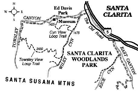
Hike Towsley and Wiley canyons in the spacious new Santa Clarita Woodlands park, north of the San Fernando Valley.
The Santa Clarita Woodlands Park, north of the arid San Fernando Valley and just west of Santa Clarita's dry hills and valleys, encompasses a surprising assortment of strange geologic features and several surprisingly lush canyons. For 120 years, the Chevron (formerly Standard Oil) Company owned this land, using it for oil production and grazing. In 1995, over 3000 acres of this land was transferred into the public domain. With subsequent additions, the park now includes about 4000 acres.
The 4.8-mile loop through Towsley and Wiley Canyons described here highlights several of the natural features of the new park. You'll visit an ever-changing array of habitats: riparian woodland, oak and walnut woodlands, coastal sage scrub, chaparral, and grassland.
From Interstate 5 north of L.A., exit at Calgrove Boulevard, turn west to reach the Old Road, and drive 0.2 mile south to the entrance road for Towsley Canyon/Ed Davis Park. Drive 0.6 mile west on the graded entrance road to reach the picnic area and nature center that constitutes Ed Davis Park. Park your car here and return (on foot or mountain bike) to the graded road, which continues going up the wide floodplain of Towsley Canyon. Notice the foamy, beige water flowing in the canyon's creek, the faint sulfurous smell, and gobs of tar in places. Well before any oil was extracted for commercial purposes here, the Tataviam Indians of the area used naturally occurring asphalt for medicinal applications and to seal their basketry.
The scenery improves as you reach, at 0.9 mile, the portals of the Narrows, a slotlike cleft worn through layers of sandstone and conglomerate tilted nearly vertical. The Santa Susana Mountains were built through geologic uplift along thrust faults -- a process demonstrated during the 1994 Northridge quake -- an event that caused the Santa Susanas to rise a foot or more. With all the compression going on, both underground and at the surface, it is not surprising to see a variety of folds in the rocks exposed here.
After a brief passage through the Narrows, there's a split in the road. Stay left. After another 200 yards, stay left again, and begin climbing the canyon slope to the left on what is called the Towsley View Loop Trail. It quickly evolves into a narrow, or single-track, trail (easy to negotiate on foot, tougher on a mountain bike) that steadily ascends on switchbacks through sage scrub and later through some gorgeous, almost pure stands of California walnut. Higher still, the tree canopy thins, with scattered oaks and pungent bay laurel clinging to the hillsides. There you catch sight of the hills and valleys of Santa Clarita to the north and east, which are increasingly being overrun with cookie-cutter subdivisions.
After reaching a high point of 2450 feet, the trail begins to pitch downward, executing a circuitous and sometimes steep descent down drier slopes into the shady depths of Wiley Canyon. Joining a dirt road there (3.4 miles), you turn left and head north, making your easy way down-canyon. At 4.1 miles, look carefully for your next turn, on the Canyon View Loop Trail, which rises to the left. A final, crooked 0.7-mile traverse on this trail takes you over a summit and back down to Ed Davis Park, your starting point.
Here's something you might be interested in.
Hike Towsley and Wiley canyons in the spacious new Santa Clarita Woodlands park, north of the San Fernando Valley.
Hike Towsley and Wiley canyons in the spacious new Santa Clarita Woodlands park, north of the San Fernando Valley.
The Santa Clarita Woodlands Park, north of the arid San Fernando Valley and just west of Santa Clarita's dry hills and valleys, encompasses a surprising assortment of strange geologic features and several surprisingly lush canyons. For 120 years, the Chevron (formerly Standard Oil) Company owned this land, using it for oil production and grazing. In 1995, over 3000 acres of this land was transferred into the public domain. With subsequent additions, the park now includes about 4000 acres.
The 4.8-mile loop through Towsley and Wiley Canyons described here highlights several of the natural features of the new park. You'll visit an ever-changing array of habitats: riparian woodland, oak and walnut woodlands, coastal sage scrub, chaparral, and grassland.
From Interstate 5 north of L.A., exit at Calgrove Boulevard, turn west to reach the Old Road, and drive 0.2 mile south to the entrance road for Towsley Canyon/Ed Davis Park. Drive 0.6 mile west on the graded entrance road to reach the picnic area and nature center that constitutes Ed Davis Park. Park your car here and return (on foot or mountain bike) to the graded road, which continues going up the wide floodplain of Towsley Canyon. Notice the foamy, beige water flowing in the canyon's creek, the faint sulfurous smell, and gobs of tar in places. Well before any oil was extracted for commercial purposes here, the Tataviam Indians of the area used naturally occurring asphalt for medicinal applications and to seal their basketry.
The scenery improves as you reach, at 0.9 mile, the portals of the Narrows, a slotlike cleft worn through layers of sandstone and conglomerate tilted nearly vertical. The Santa Susana Mountains were built through geologic uplift along thrust faults -- a process demonstrated during the 1994 Northridge quake -- an event that caused the Santa Susanas to rise a foot or more. With all the compression going on, both underground and at the surface, it is not surprising to see a variety of folds in the rocks exposed here.
After a brief passage through the Narrows, there's a split in the road. Stay left. After another 200 yards, stay left again, and begin climbing the canyon slope to the left on what is called the Towsley View Loop Trail. It quickly evolves into a narrow, or single-track, trail (easy to negotiate on foot, tougher on a mountain bike) that steadily ascends on switchbacks through sage scrub and later through some gorgeous, almost pure stands of California walnut. Higher still, the tree canopy thins, with scattered oaks and pungent bay laurel clinging to the hillsides. There you catch sight of the hills and valleys of Santa Clarita to the north and east, which are increasingly being overrun with cookie-cutter subdivisions.
After reaching a high point of 2450 feet, the trail begins to pitch downward, executing a circuitous and sometimes steep descent down drier slopes into the shady depths of Wiley Canyon. Joining a dirt road there (3.4 miles), you turn left and head north, making your easy way down-canyon. At 4.1 miles, look carefully for your next turn, on the Canyon View Loop Trail, which rises to the left. A final, crooked 0.7-mile traverse on this trail takes you over a summit and back down to Ed Davis Park, your starting point.