Here's something you might be interested in.
Ask a Hipster — Advice you didn't know you needed
Big Screen — Movie commentary
Blurt — Music's inside track
Booze News — San Diego spirits
Classical Music — Immortal beauty
Classifieds — Free and easy
Cover Stories — Front-page features
Drinks All Around — Bartenders' drink recipes
Excerpts — Literary and spiritual excerpts
Feast! — Food & drink reviews
Feature Stories — Local news & stories
Fishing Report — What’s getting hooked from ship and shore
From the Archives — Spotlight on the past
Golden Dreams — Talk of the town
The Gonzo Report — Making the musical scene, or at least reporting from it
Letters — Our inbox
Movies@Home — Local movie buffs share favorites
Movie Reviews — Our critics' picks and pans
Musician Interviews — Up close with local artists
Neighborhood News from Stringers — Hyperlocal news
News Ticker — News & politics
Obermeyer — San Diego politics illustrated
Outdoors — Weekly changes in flora and fauna
Overheard in San Diego — Eavesdropping illustrated
Poetry — The old and the new
Reader Travel — Travel section built by travelers
Reading — The hunt for intellectuals
Roam-O-Rama — SoCal's best hiking/biking trails
San Diego Beer — Inside San Diego suds
SD on the QT — Almost factual news
Sheep and Goats — Places of worship
Special Issues — The best of
Street Style — San Diego streets have style
Surf Diego — Real stories from those braving the waves
Theater — On stage in San Diego this week
Tin Fork — Silver spoon alternative
Under the Radar — Matt Potter's undercover work
Unforgettable — Long-ago San Diego
Unreal Estate — San Diego's priciest pads
Your Week — Daily event picks
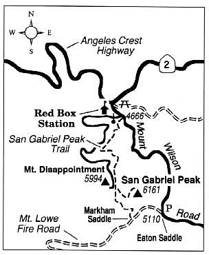
Pass on by Mount Disappointment and climb farther to San Gabriel Peak, offering the better view of the LA Basin.
San Gabriel Peak (elevation 6161 feet), is but one of the many named summits crowning the soaring, so-called "front range" of the San Gabriel Mountains north of Pasadena and the Los Angeles Basin. Years ago hikers followed a paved service road to nearby Mount Disappointment, then made a short jaunt to the slightly higher and more viewful San Gabriel Peak. In 1988, Jet Propulsion Laboratory Hiking Club volunteers completed the parallel, more scenic San Gabriel Peak Trail used by most hikers today.
Why was Mount Disappointment named as such? In 1875 surveyors were trying to establish a triangulation point atop the area's highest promontory. After a laborious struggle through dense brush they discovered they'd reached a false summit. San Gabriel Peak, 100 feet higher, lay beyond.
Today's Mount Disappointment is a disappointing shadow of its former self. The U.S. Army blasted off its top in the 1950s, installed a Nike missile base, and built the service road to the top. The flattened summit still serves as an antenna site. San Gabriel Peak's summit is not so abused and makes a fine destination for a view-hike of just over two miles.
From Interstate 210 at La Canada, drive up into the San Gabriels on Angeles Crest Highway. After 14 miles you'll come to Red Box Station and the intersection of Mount Wilson Road. Follow Mount Wilson Road 0.4 mile to a turnout for the service road on the right, which is closed to vehicles (you'll need a National Forest Adventure Pass for parking here). This turnout is also the trailhead for the San Gabriel Peak Trail, which wastes no time in zigzagging straight up the steep, oak- and conifer-shaded slopes to the west. The coniferous trees here are mostly big-cone Douglas firs, a relative of the Douglas firs of the Pacific Northwest but more scraggly and with branches that droop in an ungainly fashion.
Starting at about 0.5 mile, the trail comes abreast of the service road. It then resumes switchbacking, offering occasional conifer-framed views of the ridgeline occupied by the famed Mount Wilson Observatory, where Edwin Hubble, in the late 1920s, gathered evidence supporting the idea of an expanding universe. You come up alongside the service road again at about 1.5 miles. Beyond that the trail continues southeast over a broad saddle between Mount Disappointment and San Gabriel Peak. At the next trail junction you go left, heading east up San Gabriel Peak's flank, gaining 400 feet in about 0.4 mile to reach the summit.
San Gabriel Peak can also be climbed by way of Eaton Saddle and Markham Saddle -- a shorter and slightly easier but less scenic approach through chaparral and exposed to the hot sun.
Here's something you might be interested in.
Pass on by Mount Disappointment and climb farther to San Gabriel Peak, offering the better view of the LA Basin.
Pass on by Mount Disappointment and climb farther to San Gabriel Peak, offering the better view of the LA Basin.
San Gabriel Peak (elevation 6161 feet), is but one of the many named summits crowning the soaring, so-called "front range" of the San Gabriel Mountains north of Pasadena and the Los Angeles Basin. Years ago hikers followed a paved service road to nearby Mount Disappointment, then made a short jaunt to the slightly higher and more viewful San Gabriel Peak. In 1988, Jet Propulsion Laboratory Hiking Club volunteers completed the parallel, more scenic San Gabriel Peak Trail used by most hikers today.
Why was Mount Disappointment named as such? In 1875 surveyors were trying to establish a triangulation point atop the area's highest promontory. After a laborious struggle through dense brush they discovered they'd reached a false summit. San Gabriel Peak, 100 feet higher, lay beyond.
Today's Mount Disappointment is a disappointing shadow of its former self. The U.S. Army blasted off its top in the 1950s, installed a Nike missile base, and built the service road to the top. The flattened summit still serves as an antenna site. San Gabriel Peak's summit is not so abused and makes a fine destination for a view-hike of just over two miles.
From Interstate 210 at La Canada, drive up into the San Gabriels on Angeles Crest Highway. After 14 miles you'll come to Red Box Station and the intersection of Mount Wilson Road. Follow Mount Wilson Road 0.4 mile to a turnout for the service road on the right, which is closed to vehicles (you'll need a National Forest Adventure Pass for parking here). This turnout is also the trailhead for the San Gabriel Peak Trail, which wastes no time in zigzagging straight up the steep, oak- and conifer-shaded slopes to the west. The coniferous trees here are mostly big-cone Douglas firs, a relative of the Douglas firs of the Pacific Northwest but more scraggly and with branches that droop in an ungainly fashion.
Starting at about 0.5 mile, the trail comes abreast of the service road. It then resumes switchbacking, offering occasional conifer-framed views of the ridgeline occupied by the famed Mount Wilson Observatory, where Edwin Hubble, in the late 1920s, gathered evidence supporting the idea of an expanding universe. You come up alongside the service road again at about 1.5 miles. Beyond that the trail continues southeast over a broad saddle between Mount Disappointment and San Gabriel Peak. At the next trail junction you go left, heading east up San Gabriel Peak's flank, gaining 400 feet in about 0.4 mile to reach the summit.
San Gabriel Peak can also be climbed by way of Eaton Saddle and Markham Saddle -- a shorter and slightly easier but less scenic approach through chaparral and exposed to the hot sun.