Here's something you might be interested in.
Ask a Hipster — Advice you didn't know you needed
Big Screen — Movie commentary
Blurt — Music's inside track
Booze News — San Diego spirits
Classical Music — Immortal beauty
Classifieds — Free and easy
Cover Stories — Front-page features
Drinks All Around — Bartenders' drink recipes
Excerpts — Literary and spiritual excerpts
Feast! — Food & drink reviews
Feature Stories — Local news & stories
Fishing Report — What’s getting hooked from ship and shore
From the Archives — Spotlight on the past
Golden Dreams — Talk of the town
The Gonzo Report — Making the musical scene, or at least reporting from it
Letters — Our inbox
Movies@Home — Local movie buffs share favorites
Movie Reviews — Our critics' picks and pans
Musician Interviews — Up close with local artists
Neighborhood News from Stringers — Hyperlocal news
News Ticker — News & politics
Obermeyer — San Diego politics illustrated
Outdoors — Weekly changes in flora and fauna
Overheard in San Diego — Eavesdropping illustrated
Poetry — The old and the new
Reader Travel — Travel section built by travelers
Reading — The hunt for intellectuals
Roam-O-Rama — SoCal's best hiking/biking trails
San Diego Beer — Inside San Diego suds
SD on the QT — Almost factual news
Sheep and Goats — Places of worship
Special Issues — The best of
Street Style — San Diego streets have style
Surf Diego — Real stories from those braving the waves
Theater — On stage in San Diego this week
Tin Fork — Silver spoon alternative
Under the Radar — Matt Potter's undercover work
Unforgettable — Long-ago San Diego
Unreal Estate — San Diego's priciest pads
Your Week — Daily event picks
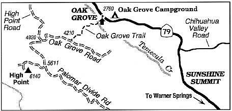
Climb the back side of Palomar Mountain, from foot to head, by way of the Oak Grove Trail.
How's this for a challenging climb of Palomar Mountain from bottom to top? Start at Oak Grove, along the east base of the mountain, and climb steadily up 7 miles of foot trail and fire road to reach High Point, the highest elevation within a radius of 14 miles. With a sturdy vehicle it's possible to drive to High Point -- but you'd miss the exercise that way. There's no water along this route, so plan accordingly, especially if you attempt this trip before October. Count on about eight hours for the round trip, assuming you're a fit hiker.
The tiny community of Oak Grove is 14 miles north of Warner Springs by way of Highway 79. Begin at the fire station at mile 49.1 on Highway 79. Follow the Oak Grove Trail route over dirt roads and footpaths behind the station. After crossing a small ravine just behind the station, the trail meanders up to a ridgeline and begins cutting back and forth across an old firebreak.
You're now in the "chaparral community," where chamise, ribbonwood, scrub oak, and manzanita thrive. A few coniferous trees cluster below in the ravines on either side of the ridge. As you climb, a view opens to the north toward the San Jacinto and San Bernardino mountain ranges.
At about 1.8 miles you reach unpaved Oak Grove Road. Go uphill (west) on the road and continue toward an intersection with High Point Road at 3.9 miles. Turn left and continue ascending through chaparral and oak forest to Palomar Divide Road at 5.7 miles. Go right and head west around the north flank of High Point through a cool, shady forest of oaks and pines. At 6.7 miles you veer left on the short, steep road to the summit. The 67-foot-high fire tower located here is one of the remaining few such structures in San Diego County.
When autumn Santa Ana winds blow and chase all the smog away, the view becomes spectacular. Parts of the Santa Rosa, San Ysidro, and Vallecito Mountains in the Anza-Borrego Desert are visible, along with the Laguna and Cuyamaca Mountains farther to the southeast. In the north are the real giants -- Old Baldy, San Gorgonio, and San Jacinto -- all topping 10,000 feet. On very clear days, several of the Channel Islands are visible far out in the Pacific. A lookout on duty here once reported a fire burning in Santa Barbara County, almost 200 miles away.
After your 7-mile ascent (and a net elevation gain of 3400 feet), turn around and return the same way -- a lot easier on the lungs if not the knees and legs
Here's something you might be interested in.
Climb the back side of Palomar Mountain, from foot to head, by way of the Oak Grove Trail.
Climb the back side of Palomar Mountain, from foot to head, by way of the Oak Grove Trail.
How's this for a challenging climb of Palomar Mountain from bottom to top? Start at Oak Grove, along the east base of the mountain, and climb steadily up 7 miles of foot trail and fire road to reach High Point, the highest elevation within a radius of 14 miles. With a sturdy vehicle it's possible to drive to High Point -- but you'd miss the exercise that way. There's no water along this route, so plan accordingly, especially if you attempt this trip before October. Count on about eight hours for the round trip, assuming you're a fit hiker.
The tiny community of Oak Grove is 14 miles north of Warner Springs by way of Highway 79. Begin at the fire station at mile 49.1 on Highway 79. Follow the Oak Grove Trail route over dirt roads and footpaths behind the station. After crossing a small ravine just behind the station, the trail meanders up to a ridgeline and begins cutting back and forth across an old firebreak.
You're now in the "chaparral community," where chamise, ribbonwood, scrub oak, and manzanita thrive. A few coniferous trees cluster below in the ravines on either side of the ridge. As you climb, a view opens to the north toward the San Jacinto and San Bernardino mountain ranges.
At about 1.8 miles you reach unpaved Oak Grove Road. Go uphill (west) on the road and continue toward an intersection with High Point Road at 3.9 miles. Turn left and continue ascending through chaparral and oak forest to Palomar Divide Road at 5.7 miles. Go right and head west around the north flank of High Point through a cool, shady forest of oaks and pines. At 6.7 miles you veer left on the short, steep road to the summit. The 67-foot-high fire tower located here is one of the remaining few such structures in San Diego County.
When autumn Santa Ana winds blow and chase all the smog away, the view becomes spectacular. Parts of the Santa Rosa, San Ysidro, and Vallecito Mountains in the Anza-Borrego Desert are visible, along with the Laguna and Cuyamaca Mountains farther to the southeast. In the north are the real giants -- Old Baldy, San Gorgonio, and San Jacinto -- all topping 10,000 feet. On very clear days, several of the Channel Islands are visible far out in the Pacific. A lookout on duty here once reported a fire burning in Santa Barbara County, almost 200 miles away.
After your 7-mile ascent (and a net elevation gain of 3400 feet), turn around and return the same way -- a lot easier on the lungs if not the knees and legs