Here's something you might be interested in.
Ask a Hipster — Advice you didn't know you needed
Big Screen — Movie commentary
Blurt — Music's inside track
Booze News — San Diego spirits
Classical Music — Immortal beauty
Classifieds — Free and easy
Cover Stories — Front-page features
Drinks All Around — Bartenders' drink recipes
Excerpts — Literary and spiritual excerpts
Feast! — Food & drink reviews
Feature Stories — Local news & stories
Fishing Report — What’s getting hooked from ship and shore
From the Archives — Spotlight on the past
Golden Dreams — Talk of the town
The Gonzo Report — Making the musical scene, or at least reporting from it
Letters — Our inbox
Movies@Home — Local movie buffs share favorites
Movie Reviews — Our critics' picks and pans
Musician Interviews — Up close with local artists
Neighborhood News from Stringers — Hyperlocal news
News Ticker — News & politics
Obermeyer — San Diego politics illustrated
Outdoors — Weekly changes in flora and fauna
Overheard in San Diego — Eavesdropping illustrated
Poetry — The old and the new
Reader Travel — Travel section built by travelers
Reading — The hunt for intellectuals
Roam-O-Rama — SoCal's best hiking/biking trails
San Diego Beer — Inside San Diego suds
SD on the QT — Almost factual news
Sheep and Goats — Places of worship
Special Issues — The best of
Street Style — San Diego streets have style
Surf Diego — Real stories from those braving the waves
Theater — On stage in San Diego this week
Tin Fork — Silver spoon alternative
Under the Radar — Matt Potter's undercover work
Unforgettable — Long-ago San Diego
Unreal Estate — San Diego's priciest pads
Your Week — Daily event picks
One in seven people in the U.S. can't locate their own country on a map.
Color my world
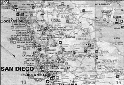
San Diego recreation map. "Most of the maps in America are not readable."
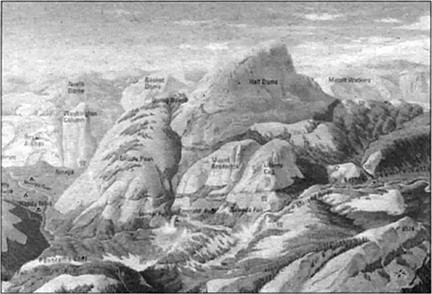
The Half Dome map is labeled in English, German, French, Spanish, and Japanese.
CALL UP THE POPULAR MAPQUEST WEBSITE ON YOUR COMPUTER AND SEARCH FOR THE TOWN OF ELVIRA, CALIFORNIA. THE MAP ON YOUR SCREEN WILL SHOW IT AT THE INTERSECTION OF 1-5 AND HIGHWAY 52, JUST EAST OF LA JOLLA. IF YOU’RE FAMILIAR WITH THE AREA, YOU KNOW THAT’S ACTUALLY THE WEST END OF TECOLOTE PARK. NO TOWN THERE, ELVIRA OR OTHERWISE.
As it happens, "Elvira” is the name given decades ago to a railroad spur line that ran east from the main Santa Fe tracks at Tecolote Canyon. On Santa Fe maps, spur-line names were significant hits of information for engineers and signalmen. For today’s traveler who relies on a road map to plan a trip or to locate landmarks, Elvira is a cartographic red herring.

Hans and Maxine Hesse: "The useful life for a map of North County is about one year, with all the building and growth. The same for areas in south county like EastLake and Chula Vista."
According to MapQuest’s creators in Pennsylvania, railroad maps were among the eight databases used to assemble their product. That’s how Elvira found her way into California. “We do our best to eliminate problems like that, but sometimes they do creep in,” MapQuest explains.
To cartographer Hans Hesse and his wife, Maxine, owners of Global Graphics in Oceanside, this tells them something about the mapmakers’ methods. “That’s a very good example of how you make a cartographic decision,” says Maxine. “In this case, they didn’t They took a database, and they just used what’s in the database and didn’t do enough research. Is it accurate? No. Is it going to get you to where you want to go? Maybe. Is it going to throw you off because you’re looking for the town of Elvira? Yeah.
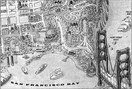
San Francisco ‘toon map
“We’ve seen maps of San Diego,” Maxine continues, “where we knew they were using an old database because they have streets down by Harbor Drive that were changed ten years ago, but they still have it the old way. So you know what they’re doing and where they got their data. However, the consumer doesn’t know.”
The Hesses have been mapmakers in California for 13 years, the last 3 in Oceanside. Hans was born in Germany and received a degree in civil engineering in Berlin in preparation for a career as a cartographer. “When I finished my studies, I went to work for a map company in Switzerland to complete my skills, I thought, for 2 years. But I stayed in Zurich for 18 years.” Switzerland is considered the world center of quality mapmaking, with a 400-year history in the art and science of cartography.
European cartographers can receive a degree in engineering with a specialty in cartography, but the Hesses aren’t aware of an equivalent program in the United States. “That’s one of the things Hans felt we could improve upon by making our own business here. The quality of American-made maps isn’t as good, generally speaking, compared to what he was doing in Europe. So we decided, we can build a better mousetrap, be self-employed, and live in this climate.” Maxine was born and raised in Southern California.
So what makes a superior map? “Accuracy,” first and foremost, Hans says. “Accuracy and legibility. Most of the maps in America are not readable. The writing is so small. Thomas Brothers is on the better side, but Rand McNally, for example, the printing is just too small.”
“And the symbology,” Maxine adds, “the way color is used. Some products are very poor. They’re using four-color, but they’re not using it well.”
Hans unfolds a commercial road map of the sprawling city of Houston and environs as an example. It’s done in garish shades of green, yellow, peach, and gray. Street names are reduced to minuscule lines of type and virtually disappear in the areas colored a too-dark, too-saturated green. The lack of contrast between the type and the color makes them difficult to read.
This is one more of the editorial and planning decisions that goes into the making of a good map, says Maxine. “Scale is one of the most important considerations for legibility. They’re using too small a scale for the size of the end product. You have a huge amount of land area covered on a sheet 28-by-36. Some of our maps are relatively small scale, similar perhaps to Rand McNally, but there are things we can do with colors and symbols and type to make them more readable.”
With the population aging, our collective eyesight dimming, legibility is an increasing problem. “We have a map of San Francisco we’ve purposely done in larger scale, but to do that you have to go onto a larger sheet, and that’s a marketing problem.”
Global Graphics currently has 30 maps and guidebooks available, most intended for tourists and visitors. They produce a California road map and maps of the state’s major cities and recreation areas, including a tourist guidebook to the San Diego/Tijuana area, plus tourist maps of Boston and New York City. Each represents at least a three- to four-month investment of time in development, says Hans. The compilation, checking, and preparation costs for a clean, accurate, legible map can cost from $5000 or $10,000 to $100,000.
To create a map from scratch. Global Graphics, like other map-makers, makes a series of editorial decisions. “First, what is the market for the map?” Maxine explains. “This determines the area covered, and you can set your borders.” Next comes historical data. “The layout of the earth, the geodetic base, that’s provided by USGS [United States Geological Survey]. Basically, the land has been photographed at some point or another, either way back by USGS in the 70s and ’80s, or before that it’s been flown over by airplane. So that’s your base. That’s public information, but it’s way out of date.
“The main streets, the old, established streets are available. What becomes the problem is getting the accuracy to reflect the current situation. Someone’s carving in a new street — now how do I know where the street’s going to go, and what’s the name of it? That’s the hard part.
“We work primarily with cities and the county and various official bodies to get our data. You go to, say, the City of Carlsbad engineering department or planning, fire departments, parks and recreation, water districts. You get freeway information from Caltrans. You assemble maps and photographs and other data, then you can start.”
Hans, the technician, the map artist, takes over from here. “You scan into the computer the geodetic information from USGS,” he says, “then you draw over it [on the computer] in freehand in different layers,” modifying the scale to match the scale of the USGS map.
He demonstrates the layer technique with a map of Los Angeles on the Mac in his home office, which runs a general graphics software package. He pulls down a list of 30 or so files on the screen. Each one is a layer of information to be overlaid on the basic USGS map, developed from historical maps and modified with current research. With a click of the mouse he can add or remove all the street names, or street numbers, or the city parks, or government buildings freeways the metro line, bus lines neighborhood names major boulevards feeder streets or other sets of detail. Standard fill-in colors for parks, buildings, freeways and the like are stored in other files to make them uniform throughout the map and make them easy to change. Any of the layers can be placed selectively on the base map to modify it for a particular market. As the face of Los Angeles changes, the master street map is updated, then those changes are transferred to any specialty maps that may be made from that database.
What Hans now does on computer, he once did painstakingly by hand when he worked in Switzerland. There he learned the negative-engraving or scribing process, in which all roads, buildings, or other landmarks are drawn by engraving into the surface of a coated sheet of film, selectively removing the coating and creating a negative the size of the finished map. This film process, too, involves assembling many layers of information to produce a finished map.
According to Hans, “The main thing that’s changed in cartography in the past ten years is the computer. The type of information you use hasn’t changed for a hundred years. It’s just the way you produce the map. The computer makes it easier to correct mistakes or update a map. With film, if you make a mistake you can change it once, and probably twice, but not a third time. Then you have a hole in the film.”
“It’s still difficult work, even on the computer,” says Maxine, “but you’re not sitting there with a scribing tool, looking through a magnifying glass."
But in the process, he admits something of the art has been lost. “When you finish a map by hand and you look at it, you think, I did it myself.’ When I finish one on the computer, it doesn’t say anything to me.”
Says Maxine, “You’re one step removed. Like the difference between writing a letter by hand and typing it on the computer.”
“Yes, exactly,” Hans says with some regret, “but you have to do it on the computer today. There is no other way.” He notes that even Swiss students of cartography are now working on Macs.
The Hesses’ home is filled with originals and reproductions of mapmaking art from as far back as the 1400s. Until that time, when hand-engraved maps could be reproduced widely, a map was a singular work. Crude maps of game trails are found on cave walls; the Babylonians and Egyptians used maps as practical items for business or taxation; for the Greeks they were items of philosophical inquiry, an offshoot of mathematics, astronomy, and geography; Roman maps were made for the military and bureaucrats. In the Middle Ages, they mapped Eden and Paradise and destroyed many of the others.
In the age of exploration, maps and charts were as valuable as gold. Pirates stole them, Spain hid them in vaults. With the development of copper engraving and printing, maps became florid works of art, more beautiful than accurate. Information, right or wrong, was borrowed from map to map, confirming for the dubious that there really were sea monsters in the waters off Asia and mermaids in the tropics. As the sciences of measurement, surveying, and aeronautics progressed, maps became more accurate, more utilitarian, though they often retained some of their elaborate borders through the 19th Century.
Among the Hesses’ collection are a reproduction of a 15th-century portolan, a ports map of the Mediterranean, the original colorfully painted on hide; a 19th-century street map of Berlin, with a florid cartouche, bordered with etchings of the city’s most significant buildings; a 19th-century map of Africa, all but the coastline completely blank; and a USGS map of Oceanside from the 1890s, the city a small dot near the huge Agua Hedionda ranch.
Some of the old touches are finding their way back into maps, as Hans demonstrates in a work-in-progress on his computer, a freeway map of Los Angeles that includes topographical features. Black snakes of freeway wind between pale-gray mountain terrain, with shaded peaks and ridges. Hans pulls a large sheet of frosted, translucent vellum from a file drawer. On it is a delicate, detailed pencil rendering of the mountains over which Hans has layered the freeway routes on his computer.
"The vellum is overlaid on a topographical map, and the artist docs a pencil drawing from it. This was done in Europe by a cartographer who specializes in relief maps. I sent him the USGS maps, 250,000 scale, he put it underneath and drew it. It took him three to four weeks.” The valleys, where the freeways are to go, have been left blank at Hans’s instruction. “So I just scan it in and put the map together.”
Hans also called on a Swiss map specialist to help with a panoramic map of Yosemite Valley. One side is a typical topographic map with the rivers, peaks, valleys, and ridges labeled with names and elevations. To this they have added major driving routes and symbols locating ranger stations, museums, campgrounds, picnic areas, parking, lodging, grocery and retail shops, bike and hiking trails, churches, medical centers, gas stations, showers, swimming pools, and tour centers.
On the reverse side are two guides to the park’s hiking trails. The first is a birds-eye-view painting of the Yosemite Valley, morning sunlight coming from the east, like seeing the valley to the horizon from a plane. The painting is complete with geologic formations, river, meadows, falls, sweeping stretches of pine trees, and the names of major distant peaks visible beyond the valley. A second painting is a detailed inset of Half Dome and its trails. The map is labeled in English, German, French, Spanish, and Japanese.
“These panoramic maps are very popular in Europe, especially Switzerland,” says Hans, “and we are trying it here.” Adds Maxine, “They interpret the topography in three dimensions, and it’s useful for people who have difficulty reading maps.”
According to Maxine, this commercial segment of the map market is probably the largest — maps for tourists and visitors. They are not only useful, they are often bought as souvenirs.
“And laminated maps are pretty popular,” says Maxine, “even though they’re more expensive than folding maps, because you can hold it easily, you can write on it. It’s pretty indestructible.”
She brings out a copy of Global Graphics’ laminated gatefold “recreation map” of Southern California, in four languages, showing freeway routes and state highways, national parks and recreation areas, and cities, counties, and towns. The map is white, with pale shades of green, gray, pink, and lavender used for the basic features. Salted across the underlying map are bright red, blue, and green squares encoded with symbols for various types of recreation. On the back of the map is the interpretive key to state beaches and parks, horseback riding, fishing piers, off-road areas, public marinas and golf courses, surfing, whale-watching, diving, ballooning, camping, sky-diving, sailplaning, skiing, and hang-gliding.
Even with this kind of map, Maxine explains, there is a lot of editing and decision-making that must go into it. “You can’t list every golf course in Southern California. You only list the major public courses." And in the data gathering, you must make sure your information is accurate.
Field checking is what the Hesses call it. Driving a route to make sure the information you’ve been given is accurate. It’s the lack of field checking that puts towns like Elvira on the map.
Maxine recalls, “Someone had something on a map, and it looked like a little dead-end street with a name. And we didn’t think it existed, so we drove out there and looked, and it turns out it was just a [service] road that turns into the parking lot of a post office, not a real street. You have to be careful. The field check is a very, very important part of cartography.” They’ve found errors in street names and spellings and other types of mis-information on source maps for their database.
In the case of the post office driveway, the original mapmaker had used that as what’s known as a trap, a small, intentional “error" to help prevent whole-sale copying of a map by someone else. “[The driveway] wasn’t a real street, but they’d drawn it as a street just for that purpose. You have to protect yourself as best you can, and that is the only way cartographers can do that.” Thomas Brothers are said to have at least one trap on virtually every page of their popular atlases.
But in a world that values speed over accuracy, can people really appreciate a quality map? One in seven people in the U.S. can’t locate their own country on a map. One in four can’t find the Pacific Ocean. According to Maxine, “Yes, I think people can appreciate a quality map. I think it’s really the lack of education, the lack of using maps in school today. If you grow up and can understand how to read them, you’re going to appreciate it more, and later on in life you’re going to look for quality. In Germany and Switzerland, every schoolchild has an atlas with a lot of detailed maps, and they learn how to use them. If you’re not exposed to them, you don’t know.
“And in a way, maps are a utilitarian tool for people, kind of ho-hum. It’s a thing that people take so much for granted that they don’t appreciate it as much as they ought to.
“And another thing is — the useful life for a map of North County is about one year, with all the building and growth. The same for areas in south county like EastLake and Chula Vista. People know they really should get a new map, but a map is like an afterthought. Right? How old is the Thomas Brothers in your car?”
Here's something you might be interested in.
One in seven people in the U.S. can't locate their own country on a map.
Color my world
One in seven people in the U.S. can't locate their own country on a map.
Color my world
San Diego recreation map. "Most of the maps in America are not readable."
The Half Dome map is labeled in English, German, French, Spanish, and Japanese.
CALL UP THE POPULAR MAPQUEST WEBSITE ON YOUR COMPUTER AND SEARCH FOR THE TOWN OF ELVIRA, CALIFORNIA. THE MAP ON YOUR SCREEN WILL SHOW IT AT THE INTERSECTION OF 1-5 AND HIGHWAY 52, JUST EAST OF LA JOLLA. IF YOU’RE FAMILIAR WITH THE AREA, YOU KNOW THAT’S ACTUALLY THE WEST END OF TECOLOTE PARK. NO TOWN THERE, ELVIRA OR OTHERWISE.
As it happens, "Elvira” is the name given decades ago to a railroad spur line that ran east from the main Santa Fe tracks at Tecolote Canyon. On Santa Fe maps, spur-line names were significant hits of information for engineers and signalmen. For today’s traveler who relies on a road map to plan a trip or to locate landmarks, Elvira is a cartographic red herring.
Hans and Maxine Hesse: "The useful life for a map of North County is about one year, with all the building and growth. The same for areas in south county like EastLake and Chula Vista."
According to MapQuest’s creators in Pennsylvania, railroad maps were among the eight databases used to assemble their product. That’s how Elvira found her way into California. “We do our best to eliminate problems like that, but sometimes they do creep in,” MapQuest explains.
To cartographer Hans Hesse and his wife, Maxine, owners of Global Graphics in Oceanside, this tells them something about the mapmakers’ methods. “That’s a very good example of how you make a cartographic decision,” says Maxine. “In this case, they didn’t They took a database, and they just used what’s in the database and didn’t do enough research. Is it accurate? No. Is it going to get you to where you want to go? Maybe. Is it going to throw you off because you’re looking for the town of Elvira? Yeah.
San Francisco ‘toon map
“We’ve seen maps of San Diego,” Maxine continues, “where we knew they were using an old database because they have streets down by Harbor Drive that were changed ten years ago, but they still have it the old way. So you know what they’re doing and where they got their data. However, the consumer doesn’t know.”
The Hesses have been mapmakers in California for 13 years, the last 3 in Oceanside. Hans was born in Germany and received a degree in civil engineering in Berlin in preparation for a career as a cartographer. “When I finished my studies, I went to work for a map company in Switzerland to complete my skills, I thought, for 2 years. But I stayed in Zurich for 18 years.” Switzerland is considered the world center of quality mapmaking, with a 400-year history in the art and science of cartography.
European cartographers can receive a degree in engineering with a specialty in cartography, but the Hesses aren’t aware of an equivalent program in the United States. “That’s one of the things Hans felt we could improve upon by making our own business here. The quality of American-made maps isn’t as good, generally speaking, compared to what he was doing in Europe. So we decided, we can build a better mousetrap, be self-employed, and live in this climate.” Maxine was born and raised in Southern California.
So what makes a superior map? “Accuracy,” first and foremost, Hans says. “Accuracy and legibility. Most of the maps in America are not readable. The writing is so small. Thomas Brothers is on the better side, but Rand McNally, for example, the printing is just too small.”
“And the symbology,” Maxine adds, “the way color is used. Some products are very poor. They’re using four-color, but they’re not using it well.”
Hans unfolds a commercial road map of the sprawling city of Houston and environs as an example. It’s done in garish shades of green, yellow, peach, and gray. Street names are reduced to minuscule lines of type and virtually disappear in the areas colored a too-dark, too-saturated green. The lack of contrast between the type and the color makes them difficult to read.
This is one more of the editorial and planning decisions that goes into the making of a good map, says Maxine. “Scale is one of the most important considerations for legibility. They’re using too small a scale for the size of the end product. You have a huge amount of land area covered on a sheet 28-by-36. Some of our maps are relatively small scale, similar perhaps to Rand McNally, but there are things we can do with colors and symbols and type to make them more readable.”
With the population aging, our collective eyesight dimming, legibility is an increasing problem. “We have a map of San Francisco we’ve purposely done in larger scale, but to do that you have to go onto a larger sheet, and that’s a marketing problem.”
Global Graphics currently has 30 maps and guidebooks available, most intended for tourists and visitors. They produce a California road map and maps of the state’s major cities and recreation areas, including a tourist guidebook to the San Diego/Tijuana area, plus tourist maps of Boston and New York City. Each represents at least a three- to four-month investment of time in development, says Hans. The compilation, checking, and preparation costs for a clean, accurate, legible map can cost from $5000 or $10,000 to $100,000.
To create a map from scratch. Global Graphics, like other map-makers, makes a series of editorial decisions. “First, what is the market for the map?” Maxine explains. “This determines the area covered, and you can set your borders.” Next comes historical data. “The layout of the earth, the geodetic base, that’s provided by USGS [United States Geological Survey]. Basically, the land has been photographed at some point or another, either way back by USGS in the 70s and ’80s, or before that it’s been flown over by airplane. So that’s your base. That’s public information, but it’s way out of date.
“The main streets, the old, established streets are available. What becomes the problem is getting the accuracy to reflect the current situation. Someone’s carving in a new street — now how do I know where the street’s going to go, and what’s the name of it? That’s the hard part.
“We work primarily with cities and the county and various official bodies to get our data. You go to, say, the City of Carlsbad engineering department or planning, fire departments, parks and recreation, water districts. You get freeway information from Caltrans. You assemble maps and photographs and other data, then you can start.”
Hans, the technician, the map artist, takes over from here. “You scan into the computer the geodetic information from USGS,” he says, “then you draw over it [on the computer] in freehand in different layers,” modifying the scale to match the scale of the USGS map.
He demonstrates the layer technique with a map of Los Angeles on the Mac in his home office, which runs a general graphics software package. He pulls down a list of 30 or so files on the screen. Each one is a layer of information to be overlaid on the basic USGS map, developed from historical maps and modified with current research. With a click of the mouse he can add or remove all the street names, or street numbers, or the city parks, or government buildings freeways the metro line, bus lines neighborhood names major boulevards feeder streets or other sets of detail. Standard fill-in colors for parks, buildings, freeways and the like are stored in other files to make them uniform throughout the map and make them easy to change. Any of the layers can be placed selectively on the base map to modify it for a particular market. As the face of Los Angeles changes, the master street map is updated, then those changes are transferred to any specialty maps that may be made from that database.
What Hans now does on computer, he once did painstakingly by hand when he worked in Switzerland. There he learned the negative-engraving or scribing process, in which all roads, buildings, or other landmarks are drawn by engraving into the surface of a coated sheet of film, selectively removing the coating and creating a negative the size of the finished map. This film process, too, involves assembling many layers of information to produce a finished map.
According to Hans, “The main thing that’s changed in cartography in the past ten years is the computer. The type of information you use hasn’t changed for a hundred years. It’s just the way you produce the map. The computer makes it easier to correct mistakes or update a map. With film, if you make a mistake you can change it once, and probably twice, but not a third time. Then you have a hole in the film.”
“It’s still difficult work, even on the computer,” says Maxine, “but you’re not sitting there with a scribing tool, looking through a magnifying glass."
But in the process, he admits something of the art has been lost. “When you finish a map by hand and you look at it, you think, I did it myself.’ When I finish one on the computer, it doesn’t say anything to me.”
Says Maxine, “You’re one step removed. Like the difference between writing a letter by hand and typing it on the computer.”
“Yes, exactly,” Hans says with some regret, “but you have to do it on the computer today. There is no other way.” He notes that even Swiss students of cartography are now working on Macs.
The Hesses’ home is filled with originals and reproductions of mapmaking art from as far back as the 1400s. Until that time, when hand-engraved maps could be reproduced widely, a map was a singular work. Crude maps of game trails are found on cave walls; the Babylonians and Egyptians used maps as practical items for business or taxation; for the Greeks they were items of philosophical inquiry, an offshoot of mathematics, astronomy, and geography; Roman maps were made for the military and bureaucrats. In the Middle Ages, they mapped Eden and Paradise and destroyed many of the others.
In the age of exploration, maps and charts were as valuable as gold. Pirates stole them, Spain hid them in vaults. With the development of copper engraving and printing, maps became florid works of art, more beautiful than accurate. Information, right or wrong, was borrowed from map to map, confirming for the dubious that there really were sea monsters in the waters off Asia and mermaids in the tropics. As the sciences of measurement, surveying, and aeronautics progressed, maps became more accurate, more utilitarian, though they often retained some of their elaborate borders through the 19th Century.
Among the Hesses’ collection are a reproduction of a 15th-century portolan, a ports map of the Mediterranean, the original colorfully painted on hide; a 19th-century street map of Berlin, with a florid cartouche, bordered with etchings of the city’s most significant buildings; a 19th-century map of Africa, all but the coastline completely blank; and a USGS map of Oceanside from the 1890s, the city a small dot near the huge Agua Hedionda ranch.
Some of the old touches are finding their way back into maps, as Hans demonstrates in a work-in-progress on his computer, a freeway map of Los Angeles that includes topographical features. Black snakes of freeway wind between pale-gray mountain terrain, with shaded peaks and ridges. Hans pulls a large sheet of frosted, translucent vellum from a file drawer. On it is a delicate, detailed pencil rendering of the mountains over which Hans has layered the freeway routes on his computer.
"The vellum is overlaid on a topographical map, and the artist docs a pencil drawing from it. This was done in Europe by a cartographer who specializes in relief maps. I sent him the USGS maps, 250,000 scale, he put it underneath and drew it. It took him three to four weeks.” The valleys, where the freeways are to go, have been left blank at Hans’s instruction. “So I just scan it in and put the map together.”
Hans also called on a Swiss map specialist to help with a panoramic map of Yosemite Valley. One side is a typical topographic map with the rivers, peaks, valleys, and ridges labeled with names and elevations. To this they have added major driving routes and symbols locating ranger stations, museums, campgrounds, picnic areas, parking, lodging, grocery and retail shops, bike and hiking trails, churches, medical centers, gas stations, showers, swimming pools, and tour centers.
On the reverse side are two guides to the park’s hiking trails. The first is a birds-eye-view painting of the Yosemite Valley, morning sunlight coming from the east, like seeing the valley to the horizon from a plane. The painting is complete with geologic formations, river, meadows, falls, sweeping stretches of pine trees, and the names of major distant peaks visible beyond the valley. A second painting is a detailed inset of Half Dome and its trails. The map is labeled in English, German, French, Spanish, and Japanese.
“These panoramic maps are very popular in Europe, especially Switzerland,” says Hans, “and we are trying it here.” Adds Maxine, “They interpret the topography in three dimensions, and it’s useful for people who have difficulty reading maps.”
According to Maxine, this commercial segment of the map market is probably the largest — maps for tourists and visitors. They are not only useful, they are often bought as souvenirs.
“And laminated maps are pretty popular,” says Maxine, “even though they’re more expensive than folding maps, because you can hold it easily, you can write on it. It’s pretty indestructible.”
She brings out a copy of Global Graphics’ laminated gatefold “recreation map” of Southern California, in four languages, showing freeway routes and state highways, national parks and recreation areas, and cities, counties, and towns. The map is white, with pale shades of green, gray, pink, and lavender used for the basic features. Salted across the underlying map are bright red, blue, and green squares encoded with symbols for various types of recreation. On the back of the map is the interpretive key to state beaches and parks, horseback riding, fishing piers, off-road areas, public marinas and golf courses, surfing, whale-watching, diving, ballooning, camping, sky-diving, sailplaning, skiing, and hang-gliding.
Even with this kind of map, Maxine explains, there is a lot of editing and decision-making that must go into it. “You can’t list every golf course in Southern California. You only list the major public courses." And in the data gathering, you must make sure your information is accurate.
Field checking is what the Hesses call it. Driving a route to make sure the information you’ve been given is accurate. It’s the lack of field checking that puts towns like Elvira on the map.
Maxine recalls, “Someone had something on a map, and it looked like a little dead-end street with a name. And we didn’t think it existed, so we drove out there and looked, and it turns out it was just a [service] road that turns into the parking lot of a post office, not a real street. You have to be careful. The field check is a very, very important part of cartography.” They’ve found errors in street names and spellings and other types of mis-information on source maps for their database.
In the case of the post office driveway, the original mapmaker had used that as what’s known as a trap, a small, intentional “error" to help prevent whole-sale copying of a map by someone else. “[The driveway] wasn’t a real street, but they’d drawn it as a street just for that purpose. You have to protect yourself as best you can, and that is the only way cartographers can do that.” Thomas Brothers are said to have at least one trap on virtually every page of their popular atlases.
But in a world that values speed over accuracy, can people really appreciate a quality map? One in seven people in the U.S. can’t locate their own country on a map. One in four can’t find the Pacific Ocean. According to Maxine, “Yes, I think people can appreciate a quality map. I think it’s really the lack of education, the lack of using maps in school today. If you grow up and can understand how to read them, you’re going to appreciate it more, and later on in life you’re going to look for quality. In Germany and Switzerland, every schoolchild has an atlas with a lot of detailed maps, and they learn how to use them. If you’re not exposed to them, you don’t know.
“And in a way, maps are a utilitarian tool for people, kind of ho-hum. It’s a thing that people take so much for granted that they don’t appreciate it as much as they ought to.
“And another thing is — the useful life for a map of North County is about one year, with all the building and growth. The same for areas in south county like EastLake and Chula Vista. People know they really should get a new map, but a map is like an afterthought. Right? How old is the Thomas Brothers in your car?”
Comments