Here's something you might be interested in.
Ask a Hipster — Advice you didn't know you needed
Big Screen — Movie commentary
Blurt — Music's inside track
Booze News — San Diego spirits
Classical Music — Immortal beauty
Classifieds — Free and easy
Cover Stories — Front-page features
Drinks All Around — Bartenders' drink recipes
Excerpts — Literary and spiritual excerpts
Feast! — Food & drink reviews
Feature Stories — Local news & stories
Fishing Report — What’s getting hooked from ship and shore
From the Archives — Spotlight on the past
Golden Dreams — Talk of the town
The Gonzo Report — Making the musical scene, or at least reporting from it
Letters — Our inbox
Movies@Home — Local movie buffs share favorites
Movie Reviews — Our critics' picks and pans
Musician Interviews — Up close with local artists
Neighborhood News from Stringers — Hyperlocal news
News Ticker — News & politics
Obermeyer — San Diego politics illustrated
Outdoors — Weekly changes in flora and fauna
Overheard in San Diego — Eavesdropping illustrated
Poetry — The old and the new
Reader Travel — Travel section built by travelers
Reading — The hunt for intellectuals
Roam-O-Rama — SoCal's best hiking/biking trails
San Diego Beer — Inside San Diego suds
SD on the QT — Almost factual news
Sheep and Goats — Places of worship
Special Issues — The best of
Street Style — San Diego streets have style
Surf Diego — Real stories from those braving the waves
Theater — On stage in San Diego this week
Tin Fork — Silver spoon alternative
Under the Radar — Matt Potter's undercover work
Unforgettable — Long-ago San Diego
Unreal Estate — San Diego's priciest pads
Your Week — Daily event picks
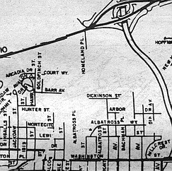
Lost Roads of San Diego, part 1 – Allen’s Dairy Rd., Harsathy St., Anna Ave., Vultee St., Homeland Ave., Suicide Alley
Travel down the streets that the local planning commission forgot
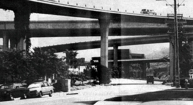
Camino del Rio South, looking east
Allen’s Dairy Road
Mission Hills is a real enclave, accessible from downtown or Mission Valley only by roundabout routes. Seventy years ago, developers didn’t want any trunk roads through this new, genteel neighborhood; near its western perimeter lay tawdry commercial strips and the muddy Mexican slum of Old Town.
Residents have maintained this insularity ever since. For example, in the early 1940s, the city wanted to build a Washington Street extension through Mission Hills to the Pacific Highway. The locals balked at the notion or a new highway cutting the neighborhood in two. So the proposed route ended up bypassing Mission Hills entirely. It veered sharply to the southwest from Washington and Hawk streets, eventually meeting Pacific Highway at the bottom of a canyon. That’s how we got the steep Washington Street extension that runs past Gelato Vero Cafe.
South end of Allen's Dairy Road at Fort Stockton Avenue
And then there’s the matter of Allen’s Dairy Road, or Allen Road, as it’s called nowadays. It runs from Fort Stockton Avenue (next to Ron Kiefer’s Gourmet Deli)> all the way down to Mission Valley, a quarter mile east of the Presidio.
North end
Leave your car and bike behind when you visit Allen Road. It’s a bonafide city street, but only the first hundred yards are paved. Therein lies our story:
In 1885 Mr. and Mrs. Sereno Allen arrived here from Kansas, went into the milk business, and raised 13 children. Their dairy prospered under sons Fred and Harvey, who owned two ranches in the valley, pioneered door-to-door delivery, and kept a retail shop in Hillcrest. It wasn’t till 1957 that Sereno’s grandson John Allen finally sold the Mission Valley spread and moved his cows to El Cajon.
During the 1920s and ’30s, the Allens used to send their milk trucks up to Mission Hills and Hillcrest via the steep-canyon path near the dairy. “It was just a little dirt road that served the dairy, which was down on a two-lane dirt road down in Mission Valley,” recalls Chuck Barr, who grew up in Mission Hills during the ’20s and ’30s. “I knew some of the Allens; I remember Richard Allen — he was the smart one in the family, got out of the dairy business, went to Cal Tech. There’s a story that the Allen kids buried the body of a Model T somewhere along the road. In the early ’30s they had this Model T that they fixed up to aquaplane along Torrey Pines beach. Well, you know, the body got rusted. So what they did was get a new body and put it on the old engine. They left the rusted old body north end alongside the road down there, and I remember there was an awful stink about it, with neighbors complaining. They never moved it, so I guess it’s still there!”
In those days city maps called this milk-truck route Canyon Road (there was already an Allen Street, near Morena Boulevard). But Mission Hills residents always called the street Allen’s Dairy Road. When the other Allen Street was obliterated by floodway plans in the 1940s, the city officially designated the Mission Valley truck-path as Allen Road and made plans to grade and pave it.
As depicted in a 1963 Texaco map
Mission Hills residents blocked the proposed improvement for 20 years. In the 1960s the city finally gave up and posted a sign at the Mission Valley end: Road Closed, per city vehicle code.
This northern end of Allen Road is now in the back lot of the Ramada Inn on Hotel Circle. A few motels to the east, where the dairy buildings once stood, we now have the Mission Valley Inn.
Harsathy Street — Middletown
Surely you remember Colonel Agostin Haraszthy, the Hungarian-born city father who was our first sheriff in 1850 and built the first jail (his first prisoner, Roy Bean, is said to have escaped within an hour by digging his way out with a penknife). No? Come on, you must know Haraszthy, that blackguard who was later accused of embezzling at the San Francisco mint, helped start the California wine industry, and was finally eaten by alligators in Nicaragua!
Haraszthy! The man who founded Middletown and even had a street named after him!
Not too many people do remember the old adventurer, nor did they 40 years ago, when the city wiped Harasthy [sic] Street off the map.
Looking east up old Harasthy Street
The street itself is still there, it just goes by another name — Washington Street. Part of it stretches for two and a half blocks from Kettner to Pacific Highway; the remainder is used as a drive by the Convair plant at Lindbergh Field.
Harasthy Street was laid out and named in the mid-19th Century, one of many short streets that ran east-west in the vicinity. Its parallel neighbors are named for Colonel Haraszthy’s contemporaries — Bean, San Diego’s first mayor (and Judge Roy Bean’s brother); Sutherland, San Diego’s first lawyer; Clayton, the first county surveyor; Emory, hero of the battle of San Pasqual. Their stumpy little streets survive, but only just barely. Sutherland, two blocks north of the Mission Brewery, is no more than a parking lot, though it still gets a street sign. Clayton Street doesn’t even rate a sign.
The misspelling of Colonel Haraszthy’s name seems to be a mapmaker’s error. When county surveyor James Pascoe laid out the first authoritative map of San Diego in 1870, he spelled the street Harasthy; and Harasthy it remained.
Looking west toward Pacific Highway and Convair
Harasthy Street’s brightest hour came at the end of World War'll, when the city opened its new “Washington Freeway,” a short concrete highway built to provide quick access between the Pacific Highway and Route 80 (El Cajon Boulevard). After nearly a century of being a forgotten side street, little Harasthy was now one of the main drags in town.
But motorists found it all too confusing. They’d drive straight down Washington, pass the Mission Brewery building, and then suddenly discover they were on this other street with an unpronounceable name. In 1952, Harasthy was redesignated West Washington Street.
1925 map
At the corner of California Street and old Harasthy, the San Diego Trolley people plan to open a station in 1995. Its name: Washington Station. Surely poor Colonel Haraszthy deserves better.
Buchanan Avenue — University Heights/Mission Cliffs
You need a good grounding in 19th century American history to explain the street names that occur on the southwest fringes of University Heights, where that turn-of-the Century subdivision meets Hillcrest. Some are easy enough: Johnson Street, Hayes Street, Cleveland Street, Tyler, Polk, Van Buren, and Garfield streets — presidents all. But whatever were they thinking of when they came up with Blaine Street, named for the GOP nominee who lost the presidency to Grover Cleveland in 1884? The street namers must have been Republicans.
And then there’s Buchanan Avenue. Named after the saddest of Democrats, it’s one of the saddest streets in town.
How sad? It’s a canyon path covered with weeds. No one is ever recorded to have built so much as an outhouse there. But Buchanan Avenue still appears on the Thomas Bros, maps of San Diego.
Buchanan Avenue by Route 163 in Mission Valley, looking north
Buchanan Avenue was laid out as University Heights’s only direct approach to Mission Valley. When contractors paved the local streets in the early 1920s, they left a 50-foot gap in the walk along Johnson Street. This is where Buchanan Avenue was supposed to fork off from Johnson. Seventy years later, the gap is still there. Beyond it lies the ridge of a canyon that meanders north and northwest to Mission Valley.
1925 map
You can see a bit more evidence of a road at Buchanan’s northern end. Go down into Mission Valley and park in the lot of the Holiday Spa. At the southern end of the lot you’ll find a one-lane dirt-and-gravel path that leads you southeast for 200 yards, then forks into two dirt roads. On the left, leading north, you have the remnant of Massachusetts Avenue, a short, paved stump of which still thrives in Mission Cliffs. The right fork, leading southeast, is Buchanan Avenue, vanishing quickly into weeds and rubble.
Looking southwest from Mission Cliffs; the unpaved Massachusetts Avenue meets Buchanan in the center of the photograph
Why weren’t these canyon roads ever finished? An old timer in Mission Cliffs says, “It’s nice and quiet up here. Don’t want strangers driving by all the time.”
Anna Avenue — Morena Area
Anna Avenue nestles among thoroughfares named for 19th-century generals — Grant Street, Custer Street, Sherman Street —- so you might suppose that the street is a tribute to the mid-century Mexican dictator General Santa Anna. Actually, Anna is very much a girl, the sole survivor of a trio of sister streets laid out at the turn of the century near the southeast corner of Mission Bay. Isabel Street, to the northeast, and Margaret Street, to the southwest, were stillborn: planned but never developed or paved.
A stump of Anna, just west of the railroad tracks
Little Anna thrived and grew, eventually crossing the Santa Fe railroad tracks and meeting up with Sherman Avenue. When the Pacific Highway opened in 1933, Anna was the access route between the businesses on the old Route 101 (Morena Avenue) and the new highway. Around the same time, an airfield called Peik Airport started up near Mission Bay, just north of the present-day Highway Patrol headquarters. And the main road to Peik Field — in fact, the only road — was Anna Avenue.
1925 map
By the start of World War II, Anna was a wonder. You could walk its entire length in 15 minutes, yet go from a railroad freight yard to a major U.S. Highway to an airport. But Peik Field shut down during the war, and a few years later (1950) Santa Fe raised its trackbed, cutting Anna in two. The worst blows came in the ’50s and ’60s, when Mission Bay Park and Interstate 5 buried all of Anna west of Pacific Highway.
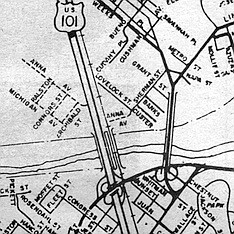
1957 map
Two stumps of Anna remain today, bisected by the train tracks. The western one serves as a frontage road for businesses along Pacific Highway. The eastern stump, by the San Diego Humane Society, is not even marked by a street sign.
Route 101: “Suicide Alley” — Morena Area
Any local who had a driver’s license a generation ago can tell you about “Suicide Alley,” a stretch of the Pacific Highway just north of the Flood Control Channel. It was built in 1933, when the Morena Avenue route of U.S. 101 was being replaced by a new concrete highway to the west.
Thirty-odd years ago, this was the worst freeway bottleneck in the county. See the concrete bridge in the photo? The highway approached this structure in a shallow curve and then suddenly narrowed: the bridge had been built to accommodate narrow-body flivvers of the early ’30s, and its four lanes were scarcely wider than a two-lane freeway of the 1950s.
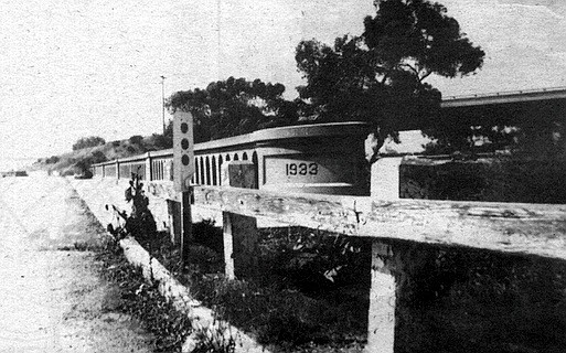
"Suicide Alley" bridge, looking south
In the mid-’60s the state bypassed this bottleneck by building an overpass extension that curved to the northwest, re-connecting with Route 101 near Mission Bay, and finally terminating at Sea World Drive (then called South Mission Bay Drive or the Sunset Cliffs Boulevard extension). In 1969 the bridge was bypassed again by the newly opened Interstate 5.
Looking southeast: Convair Street, near its intersection with Liberator Street (now called East Street)
Today this 300-yard section of highway and bridge is a frontage road for the Pacific Highway. It dead-ends suddenly at a storage warehouse.
1963 map
Sharp-eyed 101-watchers will note that the bridge pictured has identical siblings elsewhere in town: on Mission Bay Drive in Pacific Beach and on North Torrey Pines Road, just south of Del Mar.
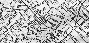
Convair Street, Vultee Street — Sports Arena Area
In 1944, the land between Midway Drive and Sports Arena Boulevard (then Frontier Street) became honeys combed with the short streets of a wartime housing project. After the war-workers went home, a motley collection of transients lived in the area. One was young Barbara Wood Graham, a fleet-following party girl who died in the electric chair in 1955 (Susan Hayward won an Oscar for playing her in I Want to Live!). Another was the brilliant German scientist Arthur Rudolph, whose Saturn rockets took us to the moon.
The Frontier housing project was closed in the early ’60s, and most of its streets obliterated. Liberator Street, named for the B-24 bomber, is now called East Street, a shopping-center route that runs by a Target outlet. Dartmouth Street is now a parking-lot drive in front of Home Depot; Convair Street, where they park the shopping carts for Ralphs supermarket.
1957 map
Vultee Street is today nothing more than parking spaces for one of those huge lots across from the Sports Arena. This photo is taken from the approximate spot of 3203 Vultee Street, where Dr. Rudolph lived with his family from 1946 to 1947.
Homeland Place — Mission Valley
Savvy drivers in Mission Valley and Hillcrest know all about Bachman Road. It’s that semi-secret, semi-private canyon drive just west of the I-8-Route 163 interchange. Bachman connects Hotel Circle South with Bachman Place in Hillcrest and allows you to get from Mission Valley to Washington Street without getting on the freeway.
Trouble is, you’re not supposed to use Bachman Road unless you’re an employee of the UCSD Medical Center. UCSD took over this right-of-way in the mid-’80s in order to have an access road to their parking garage on Pill Hill.
Non-legit users of Bachman hardly ever get caught or fined. If security guards ask you for your ID, you can just say you’re lost, and they’ll happily show you the way out.
Homeland Place in its present incarnation as Bachman Road
If you’re in a belligerent mood, though, you may wish to insist that you have an easement to use the road. After all, the portion of Bachman in Mission Valley was for decades a city street called Homeland Place, a cul-de-sac that primarily served one of the local dairies. And at the Hillcrest end of the road is another city street, Bachman Place.
You might point out that you’ve been driving up this canyon every day for the last 50 years, and it’s not your fault if these Medical Center whippersnappers have gone and built themselves a parking garage near two of your favorite roads!
Maple Canyon Road — Bankers Hill/Hillcrest
In the days before I-5 tore the city core asunder with its S-curve, traffic along El Prado in Balboa Park was a problem. Motorists would commonly cut across Laurel Street and drive through Balboa Park to get to their destinations. In the late ’50s, the city proposed a “Laurel Street bypass” to end the east-west congestion.
The traffic planners wanted a limited-access highway that wouldn’t disrupt existing streets. By happy circumstance, there was a deep canyon just north of Laurel Street, and it was here that they proposed to begin their new bypass.
Maple Canyon Road, as the project came to be called, was to run along the canyon floor from Laurel and Columbia and then emerge to join with Third Avenue near Redwood Street The bypass route would continue up Third, turn east on Upas, cut through the park, overpass the Cabrillo Freeway, and finally end at Robinson Street near Park Boulevard.
The never-built Maple Canyon Road (center) as seen from Front Street
Preliminary survey and design work on the road began in 1960 and continued for several years. Hillcrest residents shot down the Upas Street route, so the city proposed an alternative: build a tunnel under Quince Street, from Third Avenue to the park.
The Maple Canyon Road idea finally died in 1963, when the city found that it didn’t have the money to build tunnels under Quince or new bridges over.Cabrillo Freeway. But city traffic was tapering off by then anyway; San Diego had gone into an economic tailspin and thousands of people were moving out of town.
By the time the city’s economy recovered in the late ’60s, new freeways and traffic patterns had mooted the question of a Laurel bypass.
In the end, the Maple Canyon Road project was a good thing for the Banker Hill area. It prevented development of the canyon area during the ’50s and ’60s, when cheap apartment buildings were springing up on nearby Reynard Way. Maple Canyon between Brant Street and Third Avenue remains one of the most secluded and bucolic spots in the city.
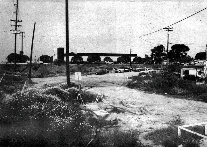
Camino del Rio South — Mission Valley, between Texas Street and Interstate 805
No other road in San Diego has seen as many name changes as the old Mission Valley Road. Seventy years ago the city decided to fancy up the two-lane dirt byway by renaming it “Camino del Rio.” The name never quite took; locals and newspaper stories alike persisted in calling it Mission Valley Road till the 1960s.
In 1949 an extension was built east of Mission Gorge Road and titled the Alvarado Freeway. A couple of years later, the western half of Mission Valley Road was regraded and paved into a four-lane highway. In the late ’50s, Alvarado Freeway and Mission Valley Road/Camino del Rio were designated U.S. Highway 80. (Until then, U.S. 80 followed El Cajon Boulevard, Normal Street, and Washington Street as far as the 395 connector. Today these streets are an T8 business loop.)
Finally, in the 1960s, the road was renamed Interstate 8.
Today’s Camino del Rio South and Camino del Rio North are mostly frontage roads built from scratch in the early ’50s. Just east and west of Texas Street, however, the Caminos are the real thing — the same two-lane, winding Mission Valley Road that the farmers used 50 or 100 years ago.
The photograph shows a portion of the road near the 805 interchange. Hemmed in by a steep grade to the south and I-8 to the north, this portion of Camino del Rio South has never bustled with roadside businesses. In the 1970s, a restaurateur built a huge crystal-palace structure on the north side of the road. It soon went under, as did the three restaurants that followed. The last failure was Tijuana Tilly’s; the current occupant is something called Banx.
In 1982, the restaurant-of-the-moment was an upscale eatery called Lehr’s Greenhouse, and the parking lot was rumored to be a good place to score an ounce of cocaine. In short order, street crime arrived in this out-of-the-way pocket of Mission Valley. The most famous incident occurred in July of that year, when city councilwoman Susan Golding and her companion, Pete Wilson aide George Gorton, were robbed at gunpoint in the Lehr’s parking lot.
This is part 1 of 3.
Here's something you might be interested in.
Lost Roads of San Diego, part 1 – Allen’s Dairy Rd., Harsathy St., Anna Ave., Vultee St., Homeland Ave., Suicide Alley
Travel down the streets that the local planning commission forgot
Lost Roads of San Diego, part 1 – Allen’s Dairy Rd., Harsathy St., Anna Ave., Vultee St., Homeland Ave., Suicide Alley
Travel down the streets that the local planning commission forgot
Camino del Rio South, looking east
Allen’s Dairy Road
Mission Hills is a real enclave, accessible from downtown or Mission Valley only by roundabout routes. Seventy years ago, developers didn’t want any trunk roads through this new, genteel neighborhood; near its western perimeter lay tawdry commercial strips and the muddy Mexican slum of Old Town.
Residents have maintained this insularity ever since. For example, in the early 1940s, the city wanted to build a Washington Street extension through Mission Hills to the Pacific Highway. The locals balked at the notion or a new highway cutting the neighborhood in two. So the proposed route ended up bypassing Mission Hills entirely. It veered sharply to the southwest from Washington and Hawk streets, eventually meeting Pacific Highway at the bottom of a canyon. That’s how we got the steep Washington Street extension that runs past Gelato Vero Cafe.
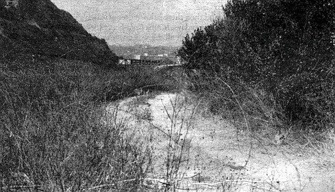
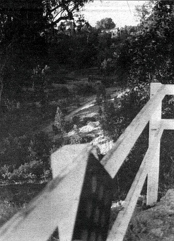
South end of Allen's Dairy Road at Fort Stockton Avenue
And then there’s the matter of Allen’s Dairy Road, or Allen Road, as it’s called nowadays. It runs from Fort Stockton Avenue (next to Ron Kiefer’s Gourmet Deli)> all the way down to Mission Valley, a quarter mile east of the Presidio.
North end
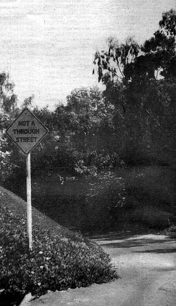
Leave your car and bike behind when you visit Allen Road. It’s a bonafide city street, but only the first hundred yards are paved. Therein lies our story:
In 1885 Mr. and Mrs. Sereno Allen arrived here from Kansas, went into the milk business, and raised 13 children. Their dairy prospered under sons Fred and Harvey, who owned two ranches in the valley, pioneered door-to-door delivery, and kept a retail shop in Hillcrest. It wasn’t till 1957 that Sereno’s grandson John Allen finally sold the Mission Valley spread and moved his cows to El Cajon.
During the 1920s and ’30s, the Allens used to send their milk trucks up to Mission Hills and Hillcrest via the steep-canyon path near the dairy. “It was just a little dirt road that served the dairy, which was down on a two-lane dirt road down in Mission Valley,” recalls Chuck Barr, who grew up in Mission Hills during the ’20s and ’30s. “I knew some of the Allens; I remember Richard Allen — he was the smart one in the family, got out of the dairy business, went to Cal Tech. There’s a story that the Allen kids buried the body of a Model T somewhere along the road. In the early ’30s they had this Model T that they fixed up to aquaplane along Torrey Pines beach. Well, you know, the body got rusted. So what they did was get a new body and put it on the old engine. They left the rusted old body north end alongside the road down there, and I remember there was an awful stink about it, with neighbors complaining. They never moved it, so I guess it’s still there!”
In those days city maps called this milk-truck route Canyon Road (there was already an Allen Street, near Morena Boulevard). But Mission Hills residents always called the street Allen’s Dairy Road. When the other Allen Street was obliterated by floodway plans in the 1940s, the city officially designated the Mission Valley truck-path as Allen Road and made plans to grade and pave it.
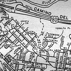
As depicted in a 1963 Texaco map
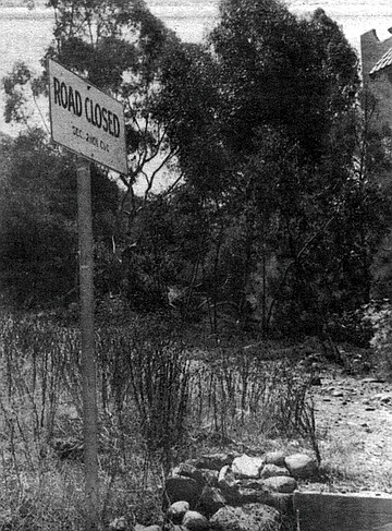
Mission Hills residents blocked the proposed improvement for 20 years. In the 1960s the city finally gave up and posted a sign at the Mission Valley end: Road Closed, per city vehicle code.
This northern end of Allen Road is now in the back lot of the Ramada Inn on Hotel Circle. A few motels to the east, where the dairy buildings once stood, we now have the Mission Valley Inn.
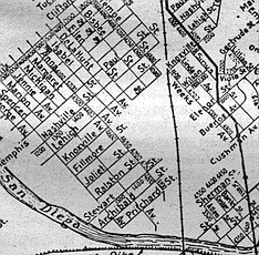
Harsathy Street — Middletown
Surely you remember Colonel Agostin Haraszthy, the Hungarian-born city father who was our first sheriff in 1850 and built the first jail (his first prisoner, Roy Bean, is said to have escaped within an hour by digging his way out with a penknife). No? Come on, you must know Haraszthy, that blackguard who was later accused of embezzling at the San Francisco mint, helped start the California wine industry, and was finally eaten by alligators in Nicaragua!
Haraszthy! The man who founded Middletown and even had a street named after him!
Not too many people do remember the old adventurer, nor did they 40 years ago, when the city wiped Harasthy [sic] Street off the map.
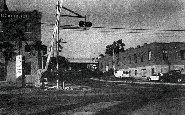
Looking east up old Harasthy Street
The street itself is still there, it just goes by another name — Washington Street. Part of it stretches for two and a half blocks from Kettner to Pacific Highway; the remainder is used as a drive by the Convair plant at Lindbergh Field.
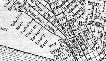
Harasthy Street was laid out and named in the mid-19th Century, one of many short streets that ran east-west in the vicinity. Its parallel neighbors are named for Colonel Haraszthy’s contemporaries — Bean, San Diego’s first mayor (and Judge Roy Bean’s brother); Sutherland, San Diego’s first lawyer; Clayton, the first county surveyor; Emory, hero of the battle of San Pasqual. Their stumpy little streets survive, but only just barely. Sutherland, two blocks north of the Mission Brewery, is no more than a parking lot, though it still gets a street sign. Clayton Street doesn’t even rate a sign.
The misspelling of Colonel Haraszthy’s name seems to be a mapmaker’s error. When county surveyor James Pascoe laid out the first authoritative map of San Diego in 1870, he spelled the street Harasthy; and Harasthy it remained.
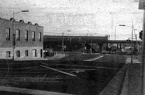
Looking west toward Pacific Highway and Convair
Harasthy Street’s brightest hour came at the end of World War'll, when the city opened its new “Washington Freeway,” a short concrete highway built to provide quick access between the Pacific Highway and Route 80 (El Cajon Boulevard). After nearly a century of being a forgotten side street, little Harasthy was now one of the main drags in town.
But motorists found it all too confusing. They’d drive straight down Washington, pass the Mission Brewery building, and then suddenly discover they were on this other street with an unpronounceable name. In 1952, Harasthy was redesignated West Washington Street.
1925 map
At the corner of California Street and old Harasthy, the San Diego Trolley people plan to open a station in 1995. Its name: Washington Station. Surely poor Colonel Haraszthy deserves better.
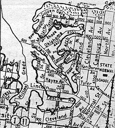
Buchanan Avenue — University Heights/Mission Cliffs
You need a good grounding in 19th century American history to explain the street names that occur on the southwest fringes of University Heights, where that turn-of-the Century subdivision meets Hillcrest. Some are easy enough: Johnson Street, Hayes Street, Cleveland Street, Tyler, Polk, Van Buren, and Garfield streets — presidents all. But whatever were they thinking of when they came up with Blaine Street, named for the GOP nominee who lost the presidency to Grover Cleveland in 1884? The street namers must have been Republicans.
And then there’s Buchanan Avenue. Named after the saddest of Democrats, it’s one of the saddest streets in town.
How sad? It’s a canyon path covered with weeds. No one is ever recorded to have built so much as an outhouse there. But Buchanan Avenue still appears on the Thomas Bros, maps of San Diego.
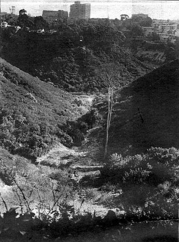
Buchanan Avenue by Route 163 in Mission Valley, looking north
Buchanan Avenue was laid out as University Heights’s only direct approach to Mission Valley. When contractors paved the local streets in the early 1920s, they left a 50-foot gap in the walk along Johnson Street. This is where Buchanan Avenue was supposed to fork off from Johnson. Seventy years later, the gap is still there. Beyond it lies the ridge of a canyon that meanders north and northwest to Mission Valley.
1925 map
You can see a bit more evidence of a road at Buchanan’s northern end. Go down into Mission Valley and park in the lot of the Holiday Spa. At the southern end of the lot you’ll find a one-lane dirt-and-gravel path that leads you southeast for 200 yards, then forks into two dirt roads. On the left, leading north, you have the remnant of Massachusetts Avenue, a short, paved stump of which still thrives in Mission Cliffs. The right fork, leading southeast, is Buchanan Avenue, vanishing quickly into weeds and rubble.
Looking southwest from Mission Cliffs; the unpaved Massachusetts Avenue meets Buchanan in the center of the photograph
Why weren’t these canyon roads ever finished? An old timer in Mission Cliffs says, “It’s nice and quiet up here. Don’t want strangers driving by all the time.”
Anna Avenue — Morena Area
Anna Avenue nestles among thoroughfares named for 19th-century generals — Grant Street, Custer Street, Sherman Street —- so you might suppose that the street is a tribute to the mid-century Mexican dictator General Santa Anna. Actually, Anna is very much a girl, the sole survivor of a trio of sister streets laid out at the turn of the century near the southeast corner of Mission Bay. Isabel Street, to the northeast, and Margaret Street, to the southwest, were stillborn: planned but never developed or paved.
A stump of Anna, just west of the railroad tracks
Little Anna thrived and grew, eventually crossing the Santa Fe railroad tracks and meeting up with Sherman Avenue. When the Pacific Highway opened in 1933, Anna was the access route between the businesses on the old Route 101 (Morena Avenue) and the new highway. Around the same time, an airfield called Peik Airport started up near Mission Bay, just north of the present-day Highway Patrol headquarters. And the main road to Peik Field — in fact, the only road — was Anna Avenue.
1925 map
By the start of World War II, Anna was a wonder. You could walk its entire length in 15 minutes, yet go from a railroad freight yard to a major U.S. Highway to an airport. But Peik Field shut down during the war, and a few years later (1950) Santa Fe raised its trackbed, cutting Anna in two. The worst blows came in the ’50s and ’60s, when Mission Bay Park and Interstate 5 buried all of Anna west of Pacific Highway.
1957 map
Two stumps of Anna remain today, bisected by the train tracks. The western one serves as a frontage road for businesses along Pacific Highway. The eastern stump, by the San Diego Humane Society, is not even marked by a street sign.
Route 101: “Suicide Alley” — Morena Area
Any local who had a driver’s license a generation ago can tell you about “Suicide Alley,” a stretch of the Pacific Highway just north of the Flood Control Channel. It was built in 1933, when the Morena Avenue route of U.S. 101 was being replaced by a new concrete highway to the west.
Thirty-odd years ago, this was the worst freeway bottleneck in the county. See the concrete bridge in the photo? The highway approached this structure in a shallow curve and then suddenly narrowed: the bridge had been built to accommodate narrow-body flivvers of the early ’30s, and its four lanes were scarcely wider than a two-lane freeway of the 1950s.
"Suicide Alley" bridge, looking south
In the mid-’60s the state bypassed this bottleneck by building an overpass extension that curved to the northwest, re-connecting with Route 101 near Mission Bay, and finally terminating at Sea World Drive (then called South Mission Bay Drive or the Sunset Cliffs Boulevard extension). In 1969 the bridge was bypassed again by the newly opened Interstate 5.
Looking southeast: Convair Street, near its intersection with Liberator Street (now called East Street)
Today this 300-yard section of highway and bridge is a frontage road for the Pacific Highway. It dead-ends suddenly at a storage warehouse.
1963 map
Sharp-eyed 101-watchers will note that the bridge pictured has identical siblings elsewhere in town: on Mission Bay Drive in Pacific Beach and on North Torrey Pines Road, just south of Del Mar.
Convair Street, Vultee Street — Sports Arena Area
In 1944, the land between Midway Drive and Sports Arena Boulevard (then Frontier Street) became honeys combed with the short streets of a wartime housing project. After the war-workers went home, a motley collection of transients lived in the area. One was young Barbara Wood Graham, a fleet-following party girl who died in the electric chair in 1955 (Susan Hayward won an Oscar for playing her in I Want to Live!). Another was the brilliant German scientist Arthur Rudolph, whose Saturn rockets took us to the moon.
The Frontier housing project was closed in the early ’60s, and most of its streets obliterated. Liberator Street, named for the B-24 bomber, is now called East Street, a shopping-center route that runs by a Target outlet. Dartmouth Street is now a parking-lot drive in front of Home Depot; Convair Street, where they park the shopping carts for Ralphs supermarket.
1957 map
Vultee Street is today nothing more than parking spaces for one of those huge lots across from the Sports Arena. This photo is taken from the approximate spot of 3203 Vultee Street, where Dr. Rudolph lived with his family from 1946 to 1947.
Homeland Place — Mission Valley
Savvy drivers in Mission Valley and Hillcrest know all about Bachman Road. It’s that semi-secret, semi-private canyon drive just west of the I-8-Route 163 interchange. Bachman connects Hotel Circle South with Bachman Place in Hillcrest and allows you to get from Mission Valley to Washington Street without getting on the freeway.
Trouble is, you’re not supposed to use Bachman Road unless you’re an employee of the UCSD Medical Center. UCSD took over this right-of-way in the mid-’80s in order to have an access road to their parking garage on Pill Hill.
Non-legit users of Bachman hardly ever get caught or fined. If security guards ask you for your ID, you can just say you’re lost, and they’ll happily show you the way out.
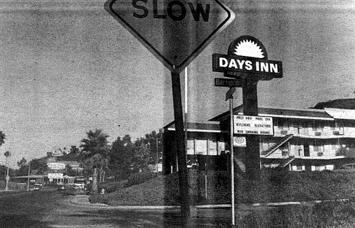
Homeland Place in its present incarnation as Bachman Road
If you’re in a belligerent mood, though, you may wish to insist that you have an easement to use the road. After all, the portion of Bachman in Mission Valley was for decades a city street called Homeland Place, a cul-de-sac that primarily served one of the local dairies. And at the Hillcrest end of the road is another city street, Bachman Place.
You might point out that you’ve been driving up this canyon every day for the last 50 years, and it’s not your fault if these Medical Center whippersnappers have gone and built themselves a parking garage near two of your favorite roads!
Maple Canyon Road — Bankers Hill/Hillcrest
In the days before I-5 tore the city core asunder with its S-curve, traffic along El Prado in Balboa Park was a problem. Motorists would commonly cut across Laurel Street and drive through Balboa Park to get to their destinations. In the late ’50s, the city proposed a “Laurel Street bypass” to end the east-west congestion.
The traffic planners wanted a limited-access highway that wouldn’t disrupt existing streets. By happy circumstance, there was a deep canyon just north of Laurel Street, and it was here that they proposed to begin their new bypass.
Maple Canyon Road, as the project came to be called, was to run along the canyon floor from Laurel and Columbia and then emerge to join with Third Avenue near Redwood Street The bypass route would continue up Third, turn east on Upas, cut through the park, overpass the Cabrillo Freeway, and finally end at Robinson Street near Park Boulevard.
The never-built Maple Canyon Road (center) as seen from Front Street
Preliminary survey and design work on the road began in 1960 and continued for several years. Hillcrest residents shot down the Upas Street route, so the city proposed an alternative: build a tunnel under Quince Street, from Third Avenue to the park.
The Maple Canyon Road idea finally died in 1963, when the city found that it didn’t have the money to build tunnels under Quince or new bridges over.Cabrillo Freeway. But city traffic was tapering off by then anyway; San Diego had gone into an economic tailspin and thousands of people were moving out of town.
By the time the city’s economy recovered in the late ’60s, new freeways and traffic patterns had mooted the question of a Laurel bypass.
In the end, the Maple Canyon Road project was a good thing for the Banker Hill area. It prevented development of the canyon area during the ’50s and ’60s, when cheap apartment buildings were springing up on nearby Reynard Way. Maple Canyon between Brant Street and Third Avenue remains one of the most secluded and bucolic spots in the city.
Camino del Rio South — Mission Valley, between Texas Street and Interstate 805
No other road in San Diego has seen as many name changes as the old Mission Valley Road. Seventy years ago the city decided to fancy up the two-lane dirt byway by renaming it “Camino del Rio.” The name never quite took; locals and newspaper stories alike persisted in calling it Mission Valley Road till the 1960s.
In 1949 an extension was built east of Mission Gorge Road and titled the Alvarado Freeway. A couple of years later, the western half of Mission Valley Road was regraded and paved into a four-lane highway. In the late ’50s, Alvarado Freeway and Mission Valley Road/Camino del Rio were designated U.S. Highway 80. (Until then, U.S. 80 followed El Cajon Boulevard, Normal Street, and Washington Street as far as the 395 connector. Today these streets are an T8 business loop.)
Finally, in the 1960s, the road was renamed Interstate 8.
Today’s Camino del Rio South and Camino del Rio North are mostly frontage roads built from scratch in the early ’50s. Just east and west of Texas Street, however, the Caminos are the real thing — the same two-lane, winding Mission Valley Road that the farmers used 50 or 100 years ago.
The photograph shows a portion of the road near the 805 interchange. Hemmed in by a steep grade to the south and I-8 to the north, this portion of Camino del Rio South has never bustled with roadside businesses. In the 1970s, a restaurateur built a huge crystal-palace structure on the north side of the road. It soon went under, as did the three restaurants that followed. The last failure was Tijuana Tilly’s; the current occupant is something called Banx.
In 1982, the restaurant-of-the-moment was an upscale eatery called Lehr’s Greenhouse, and the parking lot was rumored to be a good place to score an ounce of cocaine. In short order, street crime arrived in this out-of-the-way pocket of Mission Valley. The most famous incident occurred in July of that year, when city councilwoman Susan Golding and her companion, Pete Wilson aide George Gorton, were robbed at gunpoint in the Lehr’s parking lot.
This is part 1 of 3.
Comments