Here's something you might be interested in.
Ask a Hipster — Advice you didn't know you needed
Big Screen — Movie commentary
Blurt — Music's inside track
Booze News — San Diego spirits
Classical Music — Immortal beauty
Classifieds — Free and easy
Cover Stories — Front-page features
Drinks All Around — Bartenders' drink recipes
Excerpts — Literary and spiritual excerpts
Feast! — Food & drink reviews
Feature Stories — Local news & stories
Fishing Report — What’s getting hooked from ship and shore
From the Archives — Spotlight on the past
Golden Dreams — Talk of the town
The Gonzo Report — Making the musical scene, or at least reporting from it
Letters — Our inbox
Movies@Home — Local movie buffs share favorites
Movie Reviews — Our critics' picks and pans
Musician Interviews — Up close with local artists
Neighborhood News from Stringers — Hyperlocal news
News Ticker — News & politics
Obermeyer — San Diego politics illustrated
Outdoors — Weekly changes in flora and fauna
Overheard in San Diego — Eavesdropping illustrated
Poetry — The old and the new
Reader Travel — Travel section built by travelers
Reading — The hunt for intellectuals
Roam-O-Rama — SoCal's best hiking/biking trails
San Diego Beer — Inside San Diego suds
SD on the QT — Almost factual news
Sheep and Goats — Places of worship
Special Issues — The best of
Street Style — San Diego streets have style
Surf Diego — Real stories from those braving the waves
Theater — On stage in San Diego this week
Tin Fork — Silver spoon alternative
Under the Radar — Matt Potter's undercover work
Unforgettable — Long-ago San Diego
Unreal Estate — San Diego's priciest pads
Your Week — Daily event picks
The catastrophe that is the Salton Sea
Stout hearts and salt water
The fresh water which flows, quite by accident, into the Salton Sea instead of the Gulf of California, stubbornly turns to salt anyway.
From the top of Mount Laguna you can sometimes catch a glimpse of the Salton Sea, glistening off in the east like a desert mirage. It doesn’t seem to belong there; it somehow doesn’t seem real. If you take the fifty-mile drive down the Banning Grade from the crest of the Lagunas to the shore of the Salton Sea, you’ll see the land around you change faster than a rock slide.
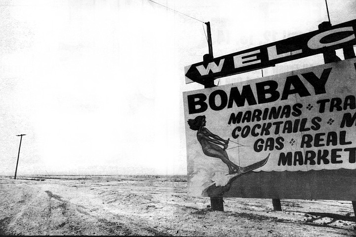
Bombay Beach. As interest in the Salton Sea as a recreation area increased, Salton City, North Shore, and Bombay Beach were born.
The cool alpine forest shrivels into a snarl of scrub oak, flowers into ocotillo, cactus blossoms through the Anza Borrego desert, then fades into a sultry flatland of thirsty ironwood and scraggly mesquite. The land has an angry look to it; without wheels and a six-pack of beer, a person could feel unwelcome here. There’s nothing but rock, sand, and a few plants tough enough to grow anywhere. Covering everything is a white crust of salt that crunches underfoot. It’s enough to make you wonder what sort of catastrophe or curse of God might have fallen on this place.
Salton Sink. Who would move, sight unseen, to a place called the Salton Sink? So developers promptly changed its name to the Imperial Valley.
The land of the Salton Sink, that area running nearly a hundred miles from Indio in the north to the Mexican border, is a land of natural catastrophes. It was a catastrophe that created the Salton Sea itself, just as it was a series of catastrophes that created and destroyed the ancient lakes that existed where the modem lake now lies. Bounded on the east by the San Andreas Fault, and about forty miles to the west by the San Jacinto Fault, the gaunt desert between has sunk to more than 260 feet below sea level; and it continues to sink, as if with all the rattling and grinding it has collapsed into a tired slouch.
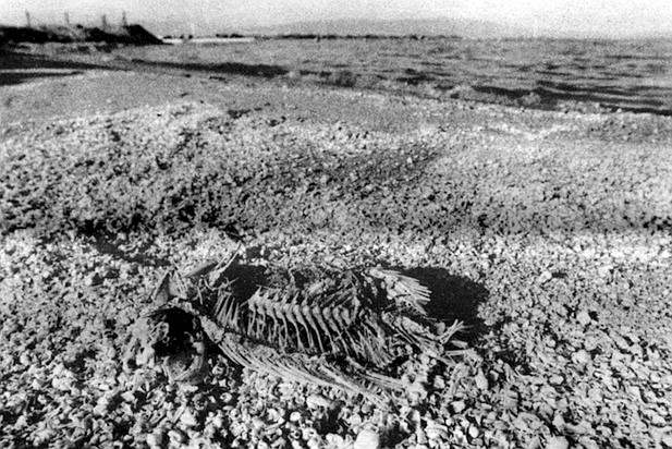
Animal corpse
The fresh water which flows, quite by accident, into the Salton Sea instead of the Gulf of California, stubbornly turns to salt anyway. The birds and the fish that have arrived since the creation of the new lake have adapted to the unique conditions of the area, but only tentatively. They’re cautiously waiting to see what the next catastrophe might be. Disaster is in the very character of this country. It’s the land’s sense of humor. And although the surrounding soil is very fertile, as it is in most of the vast Salton Sink, agriculture exists here only through a series of manipulations by man. The first of those manipulations resulted in the catastrophe that created the lake.
“The irrigation water brings with it a lot of nutrients, and this is why the fish grow so fast.’’
Around the turn of the century there was an organization called the California Development Company, whose goal was to bring water from the Colorado River to the Salton Sink, transforming it, as if in some biblical prophecy, from an inhospitable desert to a garden of choice irrigable farmland. A sister organization to the California Development Company, or CDC, was the Imperial Land Company, whose job it was to promote the marketing of the land.
In Salton Sea Beach, along the western shore, they've put up dikes along the shoreline to hold back the ever-rising water.
But who would move, sight unseen, to a place called the Salton Sink? So with a flourish characteristic of land developers, they promptly changed its name to the Imperial Valley. It had a nice sound to it, and after the CDC successfully engineered a series of canals to the valley, farmers from all over the country flocked to the place.
Neat rows of date palms grow right down to the water's edge.
The water from the river was diverted a Pilot Knob, just below Yuma. It crossed the Mexican border, then headed north again into an old overflow channel of the Colorado called the Alamo River, and into the Imperial Valley. The Mexican government, failing to see how Mexico could benefit from all this, was hesitant about granting the necessary permission. So the CDC chartered itself in Mexico as well as the U.S., and after a series of reconsiderations and adjustments on both sides, the Mexicans simply failed to express their opinion one way or the other, and the CDC went ahead with its project.
The U.S. government issued an authoritative scientific report stating that the land of the Imperial Valley was too alkaline to grow anything, but the farmers in the fields, holding the government report in one hand and huge heads of lettuce in the other, just laughed at the warning. The government’s scientists might have been spared the embarrassment had they simply asked the local Indians for advice. Even though the natives had little interest in or need for agriculture before the arrival of the white man, they knew about the alkaline soil and they understood its potential. One of their legends credits the origins of agriculture to a blue frog with three stripes running down its back. This frog slew the god Mukat, and from the victim’s body sprouted the first agricultural plants — corn, beans, and squash. This blue frog, which is native to the area, can only survive in water with alkaline levels low enough to be tolerated by most crops. The presence of that blue frog in a particular stream may have been a key to the probability of crops surviving there.
It was true that the land was alkaline; so alkaline, in fact, that every time it rained, a residue of salt formed around the edges of mud puddles. But the new farmers, without the aid of the Indians’ frog and in spite of the government’s caveat, found that the alkalai could be easily removed (fields were flooded and the water allowed to evaporate, leaving a concentration of alkaloids to be scooped out), and soon there were 10,000 people and 125,000 acres of reclaimed land in the valley, where the only previous industry had been a salt mine at the bottom of the Sink.
The Southern Pacific Railroad then realized the possibilities of the Imperial Valley, and they ran a line from Yuma to the San Gorgonio Pass on the North. This allowed the farmers to get their crops to market and gave the Southern Pacific ownership of choice land adjacent to their tracks.
The whole project appeared to be a great success for everyone involved. The only people who could possibly complain were the Cahuilla and Kamia Indians, who were being crowded out of their lands. It must have been very confusing for them to see the mesquite and screwbean plants, the cactus buds, agave, yucca, and Mormon tea. which provided them with very nutritious sources of food and which grew nearly everywhere with very little water and no maintenance, being plowed up and replaced with barley and wheat, which required a lot of water and just about all of a man’s time. Once again, no one asked their opinion in all this. If someone had asked, the Indians might have told them something about the stubborn nature of that land; perhaps they could have hinted at the catastrophe that followed.
To understand that catastrophe, you have to understand the natural history of the Salton Sink. At one time the Gulf of California extended as far north as the town of Indio, 200 miles farther than it now lies. As silt from the Colorado River gradually filled in the gulf over the centuries, the area now called the Salton Sink was cut off from the rest of the gulf by a great bar of silt. With the deposits left by the Colorado and by the tides of the gulf, this bar grew until it was about fifteen miles wide. The salt lake that was left to the north of the bar eventually evaporated, leaving part of the salt deposits now found in the Sink. Over the years, the Colorado River would periodically hop the silt bar and dump its waters into the Salton Sink. This created a series of lakes, all of which eventually evaporated. The most recent was the ancient Lake Cahuilla, originally a freshwater lake, and much larger than the Salton Sea. The shells of freshwater mollusks can be found in the Santa Rosa mountains to the west, and travertine, which is a form of limestone carried by the Colorado, can be found deposited over much of the area. Lake Cahuilla finally disappeared, too, sometime around the Sixteenth Century. Melchior Diaz, a Spanish priest, found only desert when he passed that way in 1540.
In 1904 the irrigation canals put in by the California Development Company began to clog with silt from the muddy Colorado, a prospect the developers hadn’t really considered. The carrying capacity of the canals was cut dramatically, and when the farmers saw that their crops were going to wither in the fields unless something was done, they demanded action. The CDC began dredging the canals to remove the silt, but this was obviously much too slow. The CDC painfully watched its own profits withering along with the farmers’ crops. Finally, in an act of desperation, the company cut a temporary bypass into the bank of the ancient silt deposit to allow the water to circumvent the clogged canals and run directly into the valley. This satisfied the farmers immediate needs, and the CDC, aware of the danger of such a move, planned to fill in the bypass before the next year’s summer floods. What the company didn't take into account, however, was that in the desert there are generally two heavy runoffs each year, one in the early summer when the snow melts in the mountains, and one in the winter rainy season. In this unfortunate situation, a December, 1904, flood during what turned out to be an exceptionally wet season, widened the bypass. Water ran uncontrolled into the valley, flooding the farmlands, the railroad tracks, and covering the New Liverpool Salt Company with sixty feet of water.
The CDC tried to close the gap with a dam, but it quickly washed away, and by June of 1905 the gap was sixty feet wide. Water was now rapidly filling the Sink and the CDC was on the verge of bankruptcy. The developers appealed to the Southern Pacific for help, and the Southern Pacific, seeing that its interests were in jeopardy, loaned the CDC $200,000. E.H. Harriman, president of the Southern Pacific, said with a peculiar choice of words that the money for the CDC was “to be used in paying off certain floating indebtedness and in completing and perfecting its canal system.” The CDC built a dam at a cost of $60,000, and it promptly washed out in the November, 1905, floods. The gap was now 600 feet wide, and nearly all of the Colorado was flowing into the Sink instead of the Gulf of California, where it belonged. Harriman gave another $250,000, and the Southern Pacific more or less assumed control over the California Development Company.
The summer floods of 1906 widened the gap to a half mile, and the old flood channel it ran through now came to be known as New River. The fertile valley bottom was composed only of silt, and the floods rapidly eroded thousands of acres of farmland. In the next year the Southern Pacific spent $1.5 million building levees and dams, but they all washed out as soon as the Colorado River flooded. At this point E.H. Harriman appealed to President Theodore Roosevelt for help, and the President wired back: “There is not the slightest excuse for the California Development Company waiting a single hour for the action of the Government…” The fact that Harriman at that time was being prosecuted by the Interstate Commerce Commission for other business dealings of his may have had something to do with the President’s unsympathetic reply.
In February of 1907 CDC and Southern Pacific succeeded in building two railroad trestles across the crevasse, and trains ran night and day dumping rock into the gap. Some of the rock came from as far away as Patagonia, Arizona, a distance of 480 miles. By this slow process they were finally able to force the Colorado River back into its old channel. It took more than two years to control the rampaging river, but it required another fifty or sixty years to decide what to do with the new Salton Sea.
One of the things found repeatedly in the history of the West is the amazing capacity man has had for turning catastrophe into opportunity, and then back again, until eventually it is a matter of opinion whether or not something is a success or a disaster. The Salton Sea seems to be like that. To the Indians the Salton Sea must have looked like a great joke played on the white man, demonstrating the foolishness of trying to control a river as wild as the Colorado. To the white men living in the valley the huge lake was, at least for a while, nothing but a disgusting waste of good water.
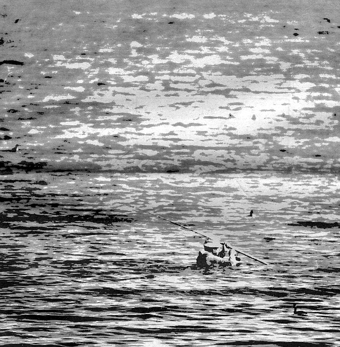
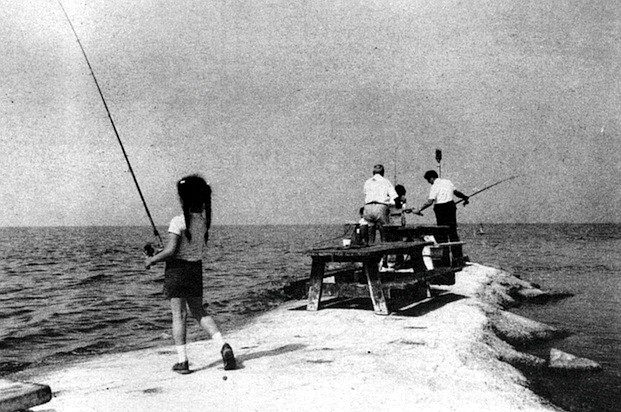
In the bottom of the Salton Sink, about eighty-five miles northeast of San Diego, there was now a sea thirty-four miles long and sixteen miles wide, making it the largest inland body of water in the state of California. It was a peculiar-looking thing, unlike anything else in the West, except perhaps the Great Salt Lake of Utah. It was ugly and useless, until someone stood on its crumbling banks and cast a fishing line into its waters. At that moment it took on a strange beauty of its own that only a fisherman could appreciate.
You can’t exactly say that the fishermen of the Salton Sea are crazy. They 're just a little odd, like the Sea itself. They sit out in that hot sun all day, enduring the crackling winds of the desert, the unique odors of the lake, and the insults of desert-crazed sea gulls. They’re the kind of fishermen who don’t really care if they catch anything. The sea could dry up, turn sterile, or once again become just a mirage, and they would still be sitting there on the banks, waiting patiently for a bite, or whatever it is they’re really waiting for. Perhaps the oddest thing of all is that they do catch fish — and nice-sized, good-eating fish at that.
When the Colorado River was spilling into the Salton Sink, it accidentally carried with it a fish called the mullet, which had the ability to live in both fresh and salt water. Born in the Gulf of California, its habits had always been to swim up the Colorado, then return to the gulf each year to spawn. Imagine what a disaster it must have been for those few mullets who had been dumped into the Salton Sea with no way to return to the gulf or the Colorado. Yet they accepted this challenge and survived. Over the years, as the sea became more saline — it had no outlet other than evaporation, and millions of tons of salt entered the Sea every year through runoff from irrigation canals — the mullets adapted with their changing environment. No doubt their ancestors had been dumped into that same Sink countless times, only to die when the ancient lakes dried up. This time, though, the sea had a steady source of water in the excess flow from the canals, and the mullets, separated from their cousins in the gulf, lived a curious life of their own in the Salton Sea.
So now there was fishing in the Sea, and the disgruntled farmers could at least stand on its banks and fish while they contemplated the waste. In the 1950s the California Department of Fish and Game took its cue from mullet and began transplanting other varieties from the Gulf of California, like the corvina, sargo, and croaker. They were all saltwater fish, and since the salinity of the Salton Sea roughly equaled that of the ocean, they did fine. Waterfowl of all kinds soon discovered this new habitat — mudhens, sandpipers, terns, great blue herons, snowy egrets, storks, and hundreds of other species made the Sea their home or used it as a resting spot along their migration routes. Barnacles were somehow introduced in the Forties, perhaps by birds or from the hulls Of boats. But they increased so rapidly that the shoreline soon turned pink from their crusty shells. The kit fox, a predator that hadn't adapted well to the invasion of man, did surprisingly well near the lake, as did the crafty coyote, which seems to be able to adjust to almost any change in its environment. The desert bighorn sheep, which has extremely sensitive mating habits, seemed to do well in the desert mountains to the east of the Sea.
Before long the Salton Sea had become popular as a recreation area. It had winter temperatures in the seventies and eighties. It was accessible from just about any direction — the old Indian trading route called the Coco-Maricopa Trail had now become Interstate 10. Motorboaters discovered that the Salton Sea was particularly good for racing; the dense salt water allowed their props to take a more positive bite. And the fishing was getting better all the time.
As interest in the Salton Sea as a recreation area increased, communities began to ooze up out of the marshy shoreline to accommodate the needs of the tourists. Salton City, North Shore, and Bombay Beach were born out of that period. Land developers divided the communities into lots, and gave the streets alluring names like Sea Nymph Drive, Azure Way, and Shoreking Drive. There were motels, marinas, playgrounds, and spas. The whole thing appeared to be as profitable as the early days of the Imperial Valley. But the character of the land hadn’t finished expressing its whimsical opinion in all this.
After the catastrophe of the runaway river, the farmers did their best to make the desert bloom again. The river was temporarily controlled by a system of small dams and levees, and the old canals were kept flowing, at great expense, by constant dredging. But everyone living in the valley still considered the Colorado River a potential menace, and in retrospect it seems clear that if the flooding of 1904 to 1907 had continued, there would have been irreparable destruction. The California Development Company had fallen into a shambles, and control of the canal system was taken over by the farmers themselves, through the organization of irrigation districts. The canal system still flowed through part of Mexico, and this led to a series of international complications that prevented any real improvement of the canal. It was around this time, about 1912, that someone first suggested an all-American canal — that is, a canal constructed entirely within American boundaries. This touched off a complex fight over who would get the water, and how much. Arizona farmers wanted their share; the farmers of the Imperial and Coachella valleys wanted their share; Los Angeles wanted water for its growing population; and something had to be left for the Mexicans. It wasn't until Hoover Dam was completed in 1935 that the Colorado River was finally controlled and regulated, assuring everyone below the dam a safe, constant flow of water. The All-American Canal, which now brings water to the Imperial Valley, wasn’t completed until 1940.
Soon after that canal opened, an agricultural boom began in earnest. Thousands of desert acres began to turn green. The farmers found, though, that the crops grown there needed more water than they might need elsewhere because of the relatively high salinity of the river water. In order to keep their fields from turning into salt beds from deposits left by irrigation, they developed a process call “tiling,” which involved digging trenches through the fields and burying hoses that collected the excess water and dissolved salts as they percolated through the soil.
It didn't take long for people living on the shore of the Salton Sea to discover that all this excess water draining off from the crops and into the Sea was causing the water level to rise. Since 1925 the water level of the Salton Sea has risen more than twenty-one feet. Last year, during Hurricane Kathleen alone, the water level rose six to eight inches.
In the communities of Salton City and Salton Sea Beach, along the western shore, they've put up dikes along the shoreline to hold back the ever-rising water. But that’s only a temporary solution at best; it can’t solve the problem. As a result, the real-estate developments aren’t doing too well. Most of the acres and acres of subdivided lots are still empty. Dandelions are growing up through the asphalt on Sea Nymph Drive. Boats lie scuttled on the main street of town. Roadrunners hustle up and down the empty roads like nervous investors. The residents understand the tentative nature of their landholdings, and they have adapted — their shelters consist of mobile homes, trailers, campers, and tents. If you can’t move in a hurry, it doesn’t belong there. If you want to add another bedroom, get a trailer. Many of the people who live in these two communities are of retirement age. They’re the ones who didn’t settle in at Rancho Bernardo or Palm Springs, but seem to do just fine in a mobile home on the Salton Sea. They’re out in the early morning, caring for their yards in the cool of the day so they’ll have the afternoon to sit in the sun and fish.
Across the Sea, in the area called North Shore, the flooding problem isn’t so bad, since they 're a little higher. Nor is the wind quite as unrelenting. The realtors of North Shore call Salton City a “blow-sand area.” In North Shore they point across the Sea and say, “Over there even the keyholes are filled with sand.’’ But North Shore isn’t experiencing a real-estate boom, either.
Agriculture is the focus on the north and south shores of the Sea. In small communities like Oasis and Mecca, to the north, everything is citrus trees, grapevines, and spinach. Neat rows of date palms grow right down to the water's edge. Snowy egrets and Virginia rails nest on the grassy banks of the irrigation canals, while grimy gas stations sweat and fume behind the hulks of dead cars. The fragrance of orange blossoms mingles with the fetid aroma of the farmworker’s slums.
On the east and west shores of the sea, sportfishing reigns supreme. According to Bill Richardson of the California Department of Fish and Game, the fishing has never been better. “The irrigation water brings with it a lot of nutrients, and this is why the fish grow so fast.’’ But the nutrients in the water also cause other forms of life to grow there. Microscopic organisms called phytoplankton are increasing in such numbers that it is feared they will use so much of the oxygen in the water that the fish will suffocate. The phytoplankton turn the water green and red, causing it to look polluted when it is actually one of the cleanest bodies of water in the state. However, the odor of the tiny organisms sometimes makes the lake unapproachable.
“The long-standing problem, though, is the increasing salinity of the sea,’’ Richardson said. “In the last six or seven years it’s stayed about the same, what with the increased water level. But that’s only because the salt is being diluted. There is still more salt entering the lake, and from a practical standpoint, there isn't much that can be done about it.*’ It’s believed that sooner or later — probably within the next twenty years — the salinity will reach a level where nothing can live in it. It will then be a dead sea.
More than ten years ago the Department of the Interior, in a geophysical survey of the Salton Sea, said, “Increasing interest in recreational uses of the sea and real-estate development on its shore . . . has led to proposals of direct action for the control of the water level and the salinity. ” But today the only thing being done is that the irrigation districts are trying to regulate their water use, both to conserve water and to lessen the excess flow that ends up in the sea. Still, the water continues to rise and the salinity can only increase.
So once again catastrophe seems imminent. Opposing elements of the Salton Sea ecology continue to jockey for dominance, just as they did in the ancient lakes that once filled the Sink. Always, though, the deciding factor has been the character of the land itself, the mood of the river, the weather, and the very movements of the earth itself. Catastrophe may turn into opportunity once again — there arc some who say that shrimp could be cultivated in the Sea more successfully than in the ocean, and the harvest might be more productive than the entire Imperial Valley. Perhaps this time it would be wiser to-wait and see what the land wants to do.
Here's something you might be interested in.
The catastrophe that is the Salton Sea
Stout hearts and salt water
The catastrophe that is the Salton Sea
Stout hearts and salt water
The fresh water which flows, quite by accident, into the Salton Sea instead of the Gulf of California, stubbornly turns to salt anyway.
From the top of Mount Laguna you can sometimes catch a glimpse of the Salton Sea, glistening off in the east like a desert mirage. It doesn’t seem to belong there; it somehow doesn’t seem real. If you take the fifty-mile drive down the Banning Grade from the crest of the Lagunas to the shore of the Salton Sea, you’ll see the land around you change faster than a rock slide.
Bombay Beach. As interest in the Salton Sea as a recreation area increased, Salton City, North Shore, and Bombay Beach were born.
The cool alpine forest shrivels into a snarl of scrub oak, flowers into ocotillo, cactus blossoms through the Anza Borrego desert, then fades into a sultry flatland of thirsty ironwood and scraggly mesquite. The land has an angry look to it; without wheels and a six-pack of beer, a person could feel unwelcome here. There’s nothing but rock, sand, and a few plants tough enough to grow anywhere. Covering everything is a white crust of salt that crunches underfoot. It’s enough to make you wonder what sort of catastrophe or curse of God might have fallen on this place.
Salton Sink. Who would move, sight unseen, to a place called the Salton Sink? So developers promptly changed its name to the Imperial Valley.
The land of the Salton Sink, that area running nearly a hundred miles from Indio in the north to the Mexican border, is a land of natural catastrophes. It was a catastrophe that created the Salton Sea itself, just as it was a series of catastrophes that created and destroyed the ancient lakes that existed where the modem lake now lies. Bounded on the east by the San Andreas Fault, and about forty miles to the west by the San Jacinto Fault, the gaunt desert between has sunk to more than 260 feet below sea level; and it continues to sink, as if with all the rattling and grinding it has collapsed into a tired slouch.
Animal corpse
The fresh water which flows, quite by accident, into the Salton Sea instead of the Gulf of California, stubbornly turns to salt anyway. The birds and the fish that have arrived since the creation of the new lake have adapted to the unique conditions of the area, but only tentatively. They’re cautiously waiting to see what the next catastrophe might be. Disaster is in the very character of this country. It’s the land’s sense of humor. And although the surrounding soil is very fertile, as it is in most of the vast Salton Sink, agriculture exists here only through a series of manipulations by man. The first of those manipulations resulted in the catastrophe that created the lake.
“The irrigation water brings with it a lot of nutrients, and this is why the fish grow so fast.’’
Around the turn of the century there was an organization called the California Development Company, whose goal was to bring water from the Colorado River to the Salton Sink, transforming it, as if in some biblical prophecy, from an inhospitable desert to a garden of choice irrigable farmland. A sister organization to the California Development Company, or CDC, was the Imperial Land Company, whose job it was to promote the marketing of the land.
In Salton Sea Beach, along the western shore, they've put up dikes along the shoreline to hold back the ever-rising water.
But who would move, sight unseen, to a place called the Salton Sink? So with a flourish characteristic of land developers, they promptly changed its name to the Imperial Valley. It had a nice sound to it, and after the CDC successfully engineered a series of canals to the valley, farmers from all over the country flocked to the place.
Neat rows of date palms grow right down to the water's edge.
The water from the river was diverted a Pilot Knob, just below Yuma. It crossed the Mexican border, then headed north again into an old overflow channel of the Colorado called the Alamo River, and into the Imperial Valley. The Mexican government, failing to see how Mexico could benefit from all this, was hesitant about granting the necessary permission. So the CDC chartered itself in Mexico as well as the U.S., and after a series of reconsiderations and adjustments on both sides, the Mexicans simply failed to express their opinion one way or the other, and the CDC went ahead with its project.
The U.S. government issued an authoritative scientific report stating that the land of the Imperial Valley was too alkaline to grow anything, but the farmers in the fields, holding the government report in one hand and huge heads of lettuce in the other, just laughed at the warning. The government’s scientists might have been spared the embarrassment had they simply asked the local Indians for advice. Even though the natives had little interest in or need for agriculture before the arrival of the white man, they knew about the alkaline soil and they understood its potential. One of their legends credits the origins of agriculture to a blue frog with three stripes running down its back. This frog slew the god Mukat, and from the victim’s body sprouted the first agricultural plants — corn, beans, and squash. This blue frog, which is native to the area, can only survive in water with alkaline levels low enough to be tolerated by most crops. The presence of that blue frog in a particular stream may have been a key to the probability of crops surviving there.
It was true that the land was alkaline; so alkaline, in fact, that every time it rained, a residue of salt formed around the edges of mud puddles. But the new farmers, without the aid of the Indians’ frog and in spite of the government’s caveat, found that the alkalai could be easily removed (fields were flooded and the water allowed to evaporate, leaving a concentration of alkaloids to be scooped out), and soon there were 10,000 people and 125,000 acres of reclaimed land in the valley, where the only previous industry had been a salt mine at the bottom of the Sink.
The Southern Pacific Railroad then realized the possibilities of the Imperial Valley, and they ran a line from Yuma to the San Gorgonio Pass on the North. This allowed the farmers to get their crops to market and gave the Southern Pacific ownership of choice land adjacent to their tracks.
The whole project appeared to be a great success for everyone involved. The only people who could possibly complain were the Cahuilla and Kamia Indians, who were being crowded out of their lands. It must have been very confusing for them to see the mesquite and screwbean plants, the cactus buds, agave, yucca, and Mormon tea. which provided them with very nutritious sources of food and which grew nearly everywhere with very little water and no maintenance, being plowed up and replaced with barley and wheat, which required a lot of water and just about all of a man’s time. Once again, no one asked their opinion in all this. If someone had asked, the Indians might have told them something about the stubborn nature of that land; perhaps they could have hinted at the catastrophe that followed.
To understand that catastrophe, you have to understand the natural history of the Salton Sink. At one time the Gulf of California extended as far north as the town of Indio, 200 miles farther than it now lies. As silt from the Colorado River gradually filled in the gulf over the centuries, the area now called the Salton Sink was cut off from the rest of the gulf by a great bar of silt. With the deposits left by the Colorado and by the tides of the gulf, this bar grew until it was about fifteen miles wide. The salt lake that was left to the north of the bar eventually evaporated, leaving part of the salt deposits now found in the Sink. Over the years, the Colorado River would periodically hop the silt bar and dump its waters into the Salton Sink. This created a series of lakes, all of which eventually evaporated. The most recent was the ancient Lake Cahuilla, originally a freshwater lake, and much larger than the Salton Sea. The shells of freshwater mollusks can be found in the Santa Rosa mountains to the west, and travertine, which is a form of limestone carried by the Colorado, can be found deposited over much of the area. Lake Cahuilla finally disappeared, too, sometime around the Sixteenth Century. Melchior Diaz, a Spanish priest, found only desert when he passed that way in 1540.
In 1904 the irrigation canals put in by the California Development Company began to clog with silt from the muddy Colorado, a prospect the developers hadn’t really considered. The carrying capacity of the canals was cut dramatically, and when the farmers saw that their crops were going to wither in the fields unless something was done, they demanded action. The CDC began dredging the canals to remove the silt, but this was obviously much too slow. The CDC painfully watched its own profits withering along with the farmers’ crops. Finally, in an act of desperation, the company cut a temporary bypass into the bank of the ancient silt deposit to allow the water to circumvent the clogged canals and run directly into the valley. This satisfied the farmers immediate needs, and the CDC, aware of the danger of such a move, planned to fill in the bypass before the next year’s summer floods. What the company didn't take into account, however, was that in the desert there are generally two heavy runoffs each year, one in the early summer when the snow melts in the mountains, and one in the winter rainy season. In this unfortunate situation, a December, 1904, flood during what turned out to be an exceptionally wet season, widened the bypass. Water ran uncontrolled into the valley, flooding the farmlands, the railroad tracks, and covering the New Liverpool Salt Company with sixty feet of water.
The CDC tried to close the gap with a dam, but it quickly washed away, and by June of 1905 the gap was sixty feet wide. Water was now rapidly filling the Sink and the CDC was on the verge of bankruptcy. The developers appealed to the Southern Pacific for help, and the Southern Pacific, seeing that its interests were in jeopardy, loaned the CDC $200,000. E.H. Harriman, president of the Southern Pacific, said with a peculiar choice of words that the money for the CDC was “to be used in paying off certain floating indebtedness and in completing and perfecting its canal system.” The CDC built a dam at a cost of $60,000, and it promptly washed out in the November, 1905, floods. The gap was now 600 feet wide, and nearly all of the Colorado was flowing into the Sink instead of the Gulf of California, where it belonged. Harriman gave another $250,000, and the Southern Pacific more or less assumed control over the California Development Company.
The summer floods of 1906 widened the gap to a half mile, and the old flood channel it ran through now came to be known as New River. The fertile valley bottom was composed only of silt, and the floods rapidly eroded thousands of acres of farmland. In the next year the Southern Pacific spent $1.5 million building levees and dams, but they all washed out as soon as the Colorado River flooded. At this point E.H. Harriman appealed to President Theodore Roosevelt for help, and the President wired back: “There is not the slightest excuse for the California Development Company waiting a single hour for the action of the Government…” The fact that Harriman at that time was being prosecuted by the Interstate Commerce Commission for other business dealings of his may have had something to do with the President’s unsympathetic reply.
In February of 1907 CDC and Southern Pacific succeeded in building two railroad trestles across the crevasse, and trains ran night and day dumping rock into the gap. Some of the rock came from as far away as Patagonia, Arizona, a distance of 480 miles. By this slow process they were finally able to force the Colorado River back into its old channel. It took more than two years to control the rampaging river, but it required another fifty or sixty years to decide what to do with the new Salton Sea.
One of the things found repeatedly in the history of the West is the amazing capacity man has had for turning catastrophe into opportunity, and then back again, until eventually it is a matter of opinion whether or not something is a success or a disaster. The Salton Sea seems to be like that. To the Indians the Salton Sea must have looked like a great joke played on the white man, demonstrating the foolishness of trying to control a river as wild as the Colorado. To the white men living in the valley the huge lake was, at least for a while, nothing but a disgusting waste of good water.
In the bottom of the Salton Sink, about eighty-five miles northeast of San Diego, there was now a sea thirty-four miles long and sixteen miles wide, making it the largest inland body of water in the state of California. It was a peculiar-looking thing, unlike anything else in the West, except perhaps the Great Salt Lake of Utah. It was ugly and useless, until someone stood on its crumbling banks and cast a fishing line into its waters. At that moment it took on a strange beauty of its own that only a fisherman could appreciate.
You can’t exactly say that the fishermen of the Salton Sea are crazy. They 're just a little odd, like the Sea itself. They sit out in that hot sun all day, enduring the crackling winds of the desert, the unique odors of the lake, and the insults of desert-crazed sea gulls. They’re the kind of fishermen who don’t really care if they catch anything. The sea could dry up, turn sterile, or once again become just a mirage, and they would still be sitting there on the banks, waiting patiently for a bite, or whatever it is they’re really waiting for. Perhaps the oddest thing of all is that they do catch fish — and nice-sized, good-eating fish at that.
When the Colorado River was spilling into the Salton Sink, it accidentally carried with it a fish called the mullet, which had the ability to live in both fresh and salt water. Born in the Gulf of California, its habits had always been to swim up the Colorado, then return to the gulf each year to spawn. Imagine what a disaster it must have been for those few mullets who had been dumped into the Salton Sea with no way to return to the gulf or the Colorado. Yet they accepted this challenge and survived. Over the years, as the sea became more saline — it had no outlet other than evaporation, and millions of tons of salt entered the Sea every year through runoff from irrigation canals — the mullets adapted with their changing environment. No doubt their ancestors had been dumped into that same Sink countless times, only to die when the ancient lakes dried up. This time, though, the sea had a steady source of water in the excess flow from the canals, and the mullets, separated from their cousins in the gulf, lived a curious life of their own in the Salton Sea.
So now there was fishing in the Sea, and the disgruntled farmers could at least stand on its banks and fish while they contemplated the waste. In the 1950s the California Department of Fish and Game took its cue from mullet and began transplanting other varieties from the Gulf of California, like the corvina, sargo, and croaker. They were all saltwater fish, and since the salinity of the Salton Sea roughly equaled that of the ocean, they did fine. Waterfowl of all kinds soon discovered this new habitat — mudhens, sandpipers, terns, great blue herons, snowy egrets, storks, and hundreds of other species made the Sea their home or used it as a resting spot along their migration routes. Barnacles were somehow introduced in the Forties, perhaps by birds or from the hulls Of boats. But they increased so rapidly that the shoreline soon turned pink from their crusty shells. The kit fox, a predator that hadn't adapted well to the invasion of man, did surprisingly well near the lake, as did the crafty coyote, which seems to be able to adjust to almost any change in its environment. The desert bighorn sheep, which has extremely sensitive mating habits, seemed to do well in the desert mountains to the east of the Sea.
Before long the Salton Sea had become popular as a recreation area. It had winter temperatures in the seventies and eighties. It was accessible from just about any direction — the old Indian trading route called the Coco-Maricopa Trail had now become Interstate 10. Motorboaters discovered that the Salton Sea was particularly good for racing; the dense salt water allowed their props to take a more positive bite. And the fishing was getting better all the time.
As interest in the Salton Sea as a recreation area increased, communities began to ooze up out of the marshy shoreline to accommodate the needs of the tourists. Salton City, North Shore, and Bombay Beach were born out of that period. Land developers divided the communities into lots, and gave the streets alluring names like Sea Nymph Drive, Azure Way, and Shoreking Drive. There were motels, marinas, playgrounds, and spas. The whole thing appeared to be as profitable as the early days of the Imperial Valley. But the character of the land hadn’t finished expressing its whimsical opinion in all this.
After the catastrophe of the runaway river, the farmers did their best to make the desert bloom again. The river was temporarily controlled by a system of small dams and levees, and the old canals were kept flowing, at great expense, by constant dredging. But everyone living in the valley still considered the Colorado River a potential menace, and in retrospect it seems clear that if the flooding of 1904 to 1907 had continued, there would have been irreparable destruction. The California Development Company had fallen into a shambles, and control of the canal system was taken over by the farmers themselves, through the organization of irrigation districts. The canal system still flowed through part of Mexico, and this led to a series of international complications that prevented any real improvement of the canal. It was around this time, about 1912, that someone first suggested an all-American canal — that is, a canal constructed entirely within American boundaries. This touched off a complex fight over who would get the water, and how much. Arizona farmers wanted their share; the farmers of the Imperial and Coachella valleys wanted their share; Los Angeles wanted water for its growing population; and something had to be left for the Mexicans. It wasn't until Hoover Dam was completed in 1935 that the Colorado River was finally controlled and regulated, assuring everyone below the dam a safe, constant flow of water. The All-American Canal, which now brings water to the Imperial Valley, wasn’t completed until 1940.
Soon after that canal opened, an agricultural boom began in earnest. Thousands of desert acres began to turn green. The farmers found, though, that the crops grown there needed more water than they might need elsewhere because of the relatively high salinity of the river water. In order to keep their fields from turning into salt beds from deposits left by irrigation, they developed a process call “tiling,” which involved digging trenches through the fields and burying hoses that collected the excess water and dissolved salts as they percolated through the soil.
It didn't take long for people living on the shore of the Salton Sea to discover that all this excess water draining off from the crops and into the Sea was causing the water level to rise. Since 1925 the water level of the Salton Sea has risen more than twenty-one feet. Last year, during Hurricane Kathleen alone, the water level rose six to eight inches.
In the communities of Salton City and Salton Sea Beach, along the western shore, they've put up dikes along the shoreline to hold back the ever-rising water. But that’s only a temporary solution at best; it can’t solve the problem. As a result, the real-estate developments aren’t doing too well. Most of the acres and acres of subdivided lots are still empty. Dandelions are growing up through the asphalt on Sea Nymph Drive. Boats lie scuttled on the main street of town. Roadrunners hustle up and down the empty roads like nervous investors. The residents understand the tentative nature of their landholdings, and they have adapted — their shelters consist of mobile homes, trailers, campers, and tents. If you can’t move in a hurry, it doesn’t belong there. If you want to add another bedroom, get a trailer. Many of the people who live in these two communities are of retirement age. They’re the ones who didn’t settle in at Rancho Bernardo or Palm Springs, but seem to do just fine in a mobile home on the Salton Sea. They’re out in the early morning, caring for their yards in the cool of the day so they’ll have the afternoon to sit in the sun and fish.
Across the Sea, in the area called North Shore, the flooding problem isn’t so bad, since they 're a little higher. Nor is the wind quite as unrelenting. The realtors of North Shore call Salton City a “blow-sand area.” In North Shore they point across the Sea and say, “Over there even the keyholes are filled with sand.’’ But North Shore isn’t experiencing a real-estate boom, either.
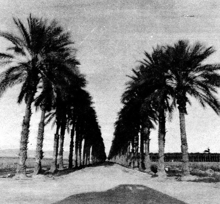
Agriculture is the focus on the north and south shores of the Sea. In small communities like Oasis and Mecca, to the north, everything is citrus trees, grapevines, and spinach. Neat rows of date palms grow right down to the water's edge. Snowy egrets and Virginia rails nest on the grassy banks of the irrigation canals, while grimy gas stations sweat and fume behind the hulks of dead cars. The fragrance of orange blossoms mingles with the fetid aroma of the farmworker’s slums.
On the east and west shores of the sea, sportfishing reigns supreme. According to Bill Richardson of the California Department of Fish and Game, the fishing has never been better. “The irrigation water brings with it a lot of nutrients, and this is why the fish grow so fast.’’ But the nutrients in the water also cause other forms of life to grow there. Microscopic organisms called phytoplankton are increasing in such numbers that it is feared they will use so much of the oxygen in the water that the fish will suffocate. The phytoplankton turn the water green and red, causing it to look polluted when it is actually one of the cleanest bodies of water in the state. However, the odor of the tiny organisms sometimes makes the lake unapproachable.
“The long-standing problem, though, is the increasing salinity of the sea,’’ Richardson said. “In the last six or seven years it’s stayed about the same, what with the increased water level. But that’s only because the salt is being diluted. There is still more salt entering the lake, and from a practical standpoint, there isn't much that can be done about it.*’ It’s believed that sooner or later — probably within the next twenty years — the salinity will reach a level where nothing can live in it. It will then be a dead sea.
More than ten years ago the Department of the Interior, in a geophysical survey of the Salton Sea, said, “Increasing interest in recreational uses of the sea and real-estate development on its shore . . . has led to proposals of direct action for the control of the water level and the salinity. ” But today the only thing being done is that the irrigation districts are trying to regulate their water use, both to conserve water and to lessen the excess flow that ends up in the sea. Still, the water continues to rise and the salinity can only increase.
So once again catastrophe seems imminent. Opposing elements of the Salton Sea ecology continue to jockey for dominance, just as they did in the ancient lakes that once filled the Sink. Always, though, the deciding factor has been the character of the land itself, the mood of the river, the weather, and the very movements of the earth itself. Catastrophe may turn into opportunity once again — there arc some who say that shrimp could be cultivated in the Sea more successfully than in the ocean, and the harvest might be more productive than the entire Imperial Valley. Perhaps this time it would be wiser to-wait and see what the land wants to do.
Comments