Here's something you might be interested in.
Ask a Hipster — Advice you didn't know you needed
Big Screen — Movie commentary
Blurt — Music's inside track
Booze News — San Diego spirits
Classical Music — Immortal beauty
Classifieds — Free and easy
Cover Stories — Front-page features
Drinks All Around — Bartenders' drink recipes
Excerpts — Literary and spiritual excerpts
Feast! — Food & drink reviews
Feature Stories — Local news & stories
Fishing Report — What’s getting hooked from ship and shore
From the Archives — Spotlight on the past
Golden Dreams — Talk of the town
The Gonzo Report — Making the musical scene, or at least reporting from it
Letters — Our inbox
Movies@Home — Local movie buffs share favorites
Movie Reviews — Our critics' picks and pans
Musician Interviews — Up close with local artists
Neighborhood News from Stringers — Hyperlocal news
News Ticker — News & politics
Obermeyer — San Diego politics illustrated
Outdoors — Weekly changes in flora and fauna
Overheard in San Diego — Eavesdropping illustrated
Poetry — The old and the new
Reader Travel — Travel section built by travelers
Reading — The hunt for intellectuals
Roam-O-Rama — SoCal's best hiking/biking trails
San Diego Beer — Inside San Diego suds
SD on the QT — Almost factual news
Sheep and Goats — Places of worship
Special Issues — The best of
Street Style — San Diego streets have style
Surf Diego — Real stories from those braving the waves
Theater — On stage in San Diego this week
Tin Fork — Silver spoon alternative
Under the Radar — Matt Potter's undercover work
Unforgettable — Long-ago San Diego
Unreal Estate — San Diego's priciest pads
Your Week — Daily event picks
From cactus to clouds in SoCal
One of California's hardest hikes... the hard way.
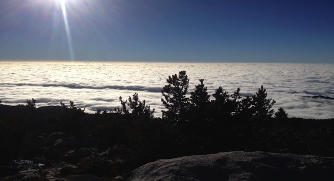
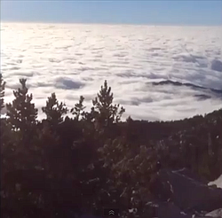
The final view of the hike from above the clouds. It took 10.5 hours, but it was worth it.
“You in town?”
Little did I know my text would lead to hiking 22 miles within the next 24 hours. Seriously. A marathon minus four miles – but with 10,500 feet of climbing, hurting, bonding, complaining and more. Let’s back up a few minutes though.
It’s 6 p.m. or so and I’m about to leave my new favorite café here in San Diego, Young Hickory. I haven’t seen a buddy of mine, Tariq, in awhile, so I text him. “You in town?”
“Did you drink last night?” Um, one cocktail. Why? “Are you going out tonight?” I don’t know. Why!?
“I’m going on a 22-mile hike at 1:30 a.m. You in? And if so, start drinking water now.”
Video:
Cactus to Clouds Hike, Palm Springs, CA
I’m not sure what to think...or how to comprehend what a 22-mile hike means, exactly. But I don’t have any set plans the weekend… and this seems like an adventure. Let’s do some Googling to figure this out.
I type “Cactus to the Clouds hike.” Yelp shows its reviews of deaths and “need to train” and blah-blahs. Not that I'm an ironman by any means, but I read reviews with a bit of suspicion.
But after reading enough blah-blahs I’m nervous, because I know that I’m in. It’s time to down some water and get four hours of shuteye before meeting Tariq. Wow. I realize that it’s easy to talk me into things (like I didn’t know this before).
What I didn’t read before hopping into my buddy’s car for a two-hour drive to the Palm Springs Museum (the base of the Cactus to Clouds hike, also known as the C2C trail) is that it’s one of the hardest day hikes in the USA.
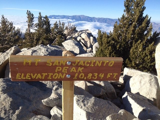
The initial 11-mile, 8,000-foot climb – the intense part of the trek – is called the Skyline Trail. Once past this point, you can take a tram back down or continue on 5.5 miles to the San Jacinto Peak (aka the “Clouds”). I can say, at this point, that I’m glad I didn’t read about any of this before going.
Ok, back to the morning of the hike at 4 a.m. We’re a group of five hikers in the Palm Spring Museum’s parking lot getting ready with our gear. One of the hikers looks at my feet and notices my tennis shoes. “You’re not wearing hiking boots?” Truth be told, I had looked for my running shoes, but unknowingly left them at a friend’s house. My Adidas tennis shoes are a back-up. And now I’m getting a bit more nervous – all these guys have some serious hiker gear with walking sticks included. Whatever. Let’s do this.
It’s dark, we all have hiking headlamps on, and the intense traversing begins. The moon is bright and the mountainside's all ours. Man, this is SO cool.
It’s starting to get light now, we’re still on an incline, and I realize that the group hasn’t stopped for a water break. Impressive. Another 30 minutes go by, and I realize that all of these guys have water packs with tubes built into their super-hiker style backpacks. They've been drinking water all along as they walk. Dude, I need a break. But between this lack of water plus only eating a banana and a brownie for breakfast (not enough electrolytes, I'm told), the damage is done.
First it’s this strange pulling sensation on the inside of my left knee. I coax myself into thinking it's nothing. But then it turns into my left and right thighs clenching up with every step. Uh-oh. Um, I might be in trouble. I fight it for 30 minutes or so before my buddy notices me walking a little (read: very) awkwardly.
It's when I'm on my back (with Tariq helping me stretch out my legs and the group of hikers patiently waiting) that I’m hit with the cold, hard truth: I AM the weakest link. We're at the 7-8 mile mark of the trail. We haven’t even gotten to the toughest part of the trail yet. My mind can’t fathom how much farther we have to go – on three separate occasions I've seen a distant peak and thought it was our ultimate mountain to climb. Only to climb it and realize there's another, higher peak awaiting us.
The group is understanding with this tennis-shoed gimp’s condition. They offer a Gu Energy Gel and tell me to drink a sports drink mix. I sincerely appreciate the concern, but I read their faces. We aren’t close to the tram. The hardest is yet to come, and I’m a liability. I know that I am and tell my friend that I’ll probably be stopping at the tram once we get there… if I get there. Man, this could get ugly. Ok, let’s go.
I’m not sure where it happens exactly: either the Gu Energy Gel kicks in, my mental powers dominate the pain (yeah right), or I’m knocked back into form when I see a mom and her 12-year-old daughter owning the trail. But I catch my second non-cramp wind. Game on.
"Are we there yet?" questions stop... finally.
I won’t go into detail about the rest of the hike, beyond that it took us 10½ hours to get to the top and about 12½ hours to finally finish. Yep, I thought about calling it quits at the tram station and hanging out while the group continued on. And I admit that the only reason I finished the last three miles of the hike was for bragging rights. I was done moving my legs.
Fast forward to the next day. I’m so sore it’s hard to walk, and I’m still bewildered that a few people in the hiking group had done this trail before. Who in their right mind would want to do C2C repeatedly? Sick people. If I had known what I know now, would I have done this hike? Not a chance at all.
Now it’s day two after the hike. I’m brushing my teeth in the morning getting ready for the week. I flash back to when I needed to grab Tariq’s boot and pull myself up over a boulder (because my tennis shoes couldn’t grab hold enough to climb). Then how, at a few points in the hike, everyone came together to share food and drinks. I smile at the tram ride when we saw how far we'd actually trekked in one day.
And it hits me: this is something I want again. Those people aren’t sick. They’re hooked on beating a challenge with friends.
Warnings: Do not do this in the summer. The temps get obnoxious. Make sure to bring electrolytes like the Gu stuff, SALTED nuts if you like nuts (your body needs the salt on the hike), energy drinks, water, etc.
Here's something you might be interested in.
From cactus to clouds in SoCal
One of California's hardest hikes... the hard way.
From cactus to clouds in SoCal
One of California's hardest hikes... the hard way.
The final view of the hike from above the clouds. It took 10.5 hours, but it was worth it.
“You in town?”
Little did I know my text would lead to hiking 22 miles within the next 24 hours. Seriously. A marathon minus four miles – but with 10,500 feet of climbing, hurting, bonding, complaining and more. Let’s back up a few minutes though.
It’s 6 p.m. or so and I’m about to leave my new favorite café here in San Diego, Young Hickory. I haven’t seen a buddy of mine, Tariq, in awhile, so I text him. “You in town?”
“Did you drink last night?” Um, one cocktail. Why? “Are you going out tonight?” I don’t know. Why!?
“I’m going on a 22-mile hike at 1:30 a.m. You in? And if so, start drinking water now.”
Video:
Cactus to Clouds Hike, Palm Springs, CA
I’m not sure what to think...or how to comprehend what a 22-mile hike means, exactly. But I don’t have any set plans the weekend… and this seems like an adventure. Let’s do some Googling to figure this out.
I type “Cactus to the Clouds hike.” Yelp shows its reviews of deaths and “need to train” and blah-blahs. Not that I'm an ironman by any means, but I read reviews with a bit of suspicion.
But after reading enough blah-blahs I’m nervous, because I know that I’m in. It’s time to down some water and get four hours of shuteye before meeting Tariq. Wow. I realize that it’s easy to talk me into things (like I didn’t know this before).
What I didn’t read before hopping into my buddy’s car for a two-hour drive to the Palm Springs Museum (the base of the Cactus to Clouds hike, also known as the C2C trail) is that it’s one of the hardest day hikes in the USA.
The initial 11-mile, 8,000-foot climb – the intense part of the trek – is called the Skyline Trail. Once past this point, you can take a tram back down or continue on 5.5 miles to the San Jacinto Peak (aka the “Clouds”). I can say, at this point, that I’m glad I didn’t read about any of this before going.
Ok, back to the morning of the hike at 4 a.m. We’re a group of five hikers in the Palm Spring Museum’s parking lot getting ready with our gear. One of the hikers looks at my feet and notices my tennis shoes. “You’re not wearing hiking boots?” Truth be told, I had looked for my running shoes, but unknowingly left them at a friend’s house. My Adidas tennis shoes are a back-up. And now I’m getting a bit more nervous – all these guys have some serious hiker gear with walking sticks included. Whatever. Let’s do this.
It’s dark, we all have hiking headlamps on, and the intense traversing begins. The moon is bright and the mountainside's all ours. Man, this is SO cool.
It’s starting to get light now, we’re still on an incline, and I realize that the group hasn’t stopped for a water break. Impressive. Another 30 minutes go by, and I realize that all of these guys have water packs with tubes built into their super-hiker style backpacks. They've been drinking water all along as they walk. Dude, I need a break. But between this lack of water plus only eating a banana and a brownie for breakfast (not enough electrolytes, I'm told), the damage is done.
First it’s this strange pulling sensation on the inside of my left knee. I coax myself into thinking it's nothing. But then it turns into my left and right thighs clenching up with every step. Uh-oh. Um, I might be in trouble. I fight it for 30 minutes or so before my buddy notices me walking a little (read: very) awkwardly.
It's when I'm on my back (with Tariq helping me stretch out my legs and the group of hikers patiently waiting) that I’m hit with the cold, hard truth: I AM the weakest link. We're at the 7-8 mile mark of the trail. We haven’t even gotten to the toughest part of the trail yet. My mind can’t fathom how much farther we have to go – on three separate occasions I've seen a distant peak and thought it was our ultimate mountain to climb. Only to climb it and realize there's another, higher peak awaiting us.
The group is understanding with this tennis-shoed gimp’s condition. They offer a Gu Energy Gel and tell me to drink a sports drink mix. I sincerely appreciate the concern, but I read their faces. We aren’t close to the tram. The hardest is yet to come, and I’m a liability. I know that I am and tell my friend that I’ll probably be stopping at the tram once we get there… if I get there. Man, this could get ugly. Ok, let’s go.
I’m not sure where it happens exactly: either the Gu Energy Gel kicks in, my mental powers dominate the pain (yeah right), or I’m knocked back into form when I see a mom and her 12-year-old daughter owning the trail. But I catch my second non-cramp wind. Game on.
"Are we there yet?" questions stop... finally.
I won’t go into detail about the rest of the hike, beyond that it took us 10½ hours to get to the top and about 12½ hours to finally finish. Yep, I thought about calling it quits at the tram station and hanging out while the group continued on. And I admit that the only reason I finished the last three miles of the hike was for bragging rights. I was done moving my legs.
Fast forward to the next day. I’m so sore it’s hard to walk, and I’m still bewildered that a few people in the hiking group had done this trail before. Who in their right mind would want to do C2C repeatedly? Sick people. If I had known what I know now, would I have done this hike? Not a chance at all.
Now it’s day two after the hike. I’m brushing my teeth in the morning getting ready for the week. I flash back to when I needed to grab Tariq’s boot and pull myself up over a boulder (because my tennis shoes couldn’t grab hold enough to climb). Then how, at a few points in the hike, everyone came together to share food and drinks. I smile at the tram ride when we saw how far we'd actually trekked in one day.
And it hits me: this is something I want again. Those people aren’t sick. They’re hooked on beating a challenge with friends.
Warnings: Do not do this in the summer. The temps get obnoxious. Make sure to bring electrolytes like the Gu stuff, SALTED nuts if you like nuts (your body needs the salt on the hike), energy drinks, water, etc.
Comments