Here's something you might be interested in.
Ask a Hipster — Advice you didn't know you needed
Big Screen — Movie commentary
Blurt — Music's inside track
Booze News — San Diego spirits
Classical Music — Immortal beauty
Classifieds — Free and easy
Cover Stories — Front-page features
Drinks All Around — Bartenders' drink recipes
Excerpts — Literary and spiritual excerpts
Feast! — Food & drink reviews
Feature Stories — Local news & stories
Fishing Report — What’s getting hooked from ship and shore
From the Archives — Spotlight on the past
Golden Dreams — Talk of the town
The Gonzo Report — Making the musical scene, or at least reporting from it
Letters — Our inbox
Movies@Home — Local movie buffs share favorites
Movie Reviews — Our critics' picks and pans
Musician Interviews — Up close with local artists
Neighborhood News from Stringers — Hyperlocal news
News Ticker — News & politics
Obermeyer — San Diego politics illustrated
Outdoors — Weekly changes in flora and fauna
Overheard in San Diego — Eavesdropping illustrated
Poetry — The old and the new
Reader Travel — Travel section built by travelers
Reading — The hunt for intellectuals
Roam-O-Rama — SoCal's best hiking/biking trails
San Diego Beer — Inside San Diego suds
SD on the QT — Almost factual news
Sheep and Goats — Places of worship
Special Issues — The best of
Street Style — San Diego streets have style
Surf Diego — Real stories from those braving the waves
Theater — On stage in San Diego this week
Tin Fork — Silver spoon alternative
Under the Radar — Matt Potter's undercover work
Unforgettable — Long-ago San Diego
Unreal Estate — San Diego's priciest pads
Your Week — Daily event picks
Inner Pasture view via Moonlight Canyon
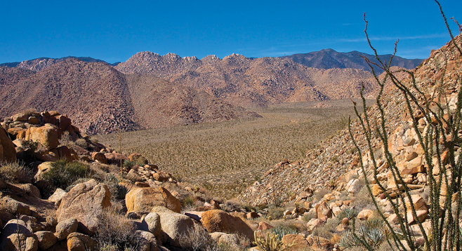
The Sawtooth Mountains loom above the Anza Borrego Desert’s Inner Pasture.
The Inner Pasture is a remarkable geographic feature of the Anza-Borrego Desert. It is a large, isolated, almost flat plane that appears to be completely surrounded by mountains. The jagged Sawtooth Mountains rise steeply on its southern and western boundary while the Tierra Blanca Mountains rise up sharply on its northern and eastern flanks. In the recent past cattle ranchers used it as a secure place to graze their cattle, but prior to that era it was home, perhaps a thousand years, to a band of Kumeyaay. During your visit to this remote location you can enjoy a silence and solitude you are unlikely to find in San Diego. Keep in mind that generations of people once lived here. Evidence of their presence is easily found in the sands and rocks of the Inner Pasture. All artifacts are protected by law — enjoy and leave them where they are found. There is also a chance to see bighorn sheep and abundant wildflowers in a wet year.
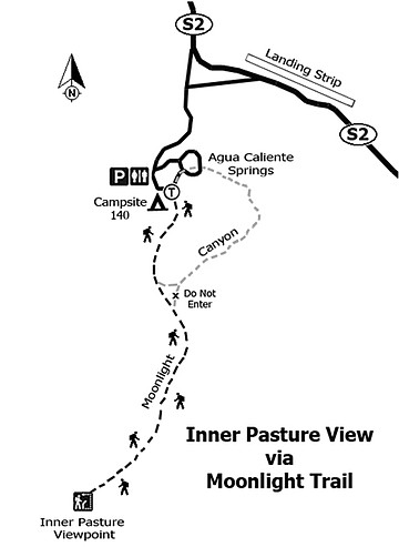
Moonlight Canyon is in the Tierra Blanca Mountains near Agua Caliente County Park. The canyon runs roughly east and west. The hike begins at the northern end of the Moonlight Canyon Loop Trail, next to campsite 140. The well-marked and heavily traveled loop trail takes you up an unnamed canyon to a saddle, then down a Moonlight Canyon tributary before it enters the named canyon. The loop trail continues to the east down the canyon, eventually returning to the campground.
To get to the Inner Pasture you need to go right at the saddle of the loop trail, in a westerly direction where a large sign is posted stating “DO NOT ENTER.” The sign warns of a 30-foot dry fall a short distance up the canyon that is not climbable and very dangerous for the average boulder hopper. Don’t try it! Instead, if you have gotten this far, go back the way you came to a small narrow canyon on your left. Here you will see a small red flag and ducks (man-made stack of stones) marking a little-used trail that leads up and over the ridge dividing this canyon from Moonlight Canyon, reaching Moonlight Canyon at a point above the unclimbable dry falls.
Now that you have been warned, you can avoid this problem by taking a somewhat easier, improvised trail that leads off to the right as you start to descend from the saddle, 0.8 mile into the hike. Again follow the ducks and keep a close eye on the faint trail, and it will also lead you to Moonlight Canyon further up from the dry falls barrier. From here the trail is easily followed, though it involves periodic boulder hopping and a few dry falls to climb, but also with long stretches of easy walking through sand. At about 2.5 miles into the hike you suddenly come to saddle overlooking the Inner Pasture and the end of Moonlight Canyon. This is a good place for lunch and perhaps a rest while enjoying the view. Return the way you came.
Distance from downtown San Diego: 115 miles via I-8 and Ocotillo; 96 miles via I-8 and SR-79; 98 miles via I-15 and SR-78. Allow about 2 hours driving time. Fastest route is I-8 to Ocotillo and then north 27 miles on SR-2 to Agua Caliente County Park. Full facilities including camping, hot springs, and store. For more information on the park visit: sdparks.org. Fee for day use — pay at the ranger station. The trailhead is next to campsite 140, across from the shuffleboard court where day use parking is available. This is also the trailhead for the Moonlight Canyon Loop Trail.
Hiking length: 5 miles out and back.
Difficulty: moderately strenuous. Elevation gain/loss 840 feet. Must carry drinking water. Trekking poles recommended. Ticks, cactus spines, heat, and rattlesnakes are the main hazards.
Here's something you might be interested in.
Inner Pasture view via Moonlight Canyon
Inner Pasture view via Moonlight Canyon
The Sawtooth Mountains loom above the Anza Borrego Desert’s Inner Pasture.
The Inner Pasture is a remarkable geographic feature of the Anza-Borrego Desert. It is a large, isolated, almost flat plane that appears to be completely surrounded by mountains. The jagged Sawtooth Mountains rise steeply on its southern and western boundary while the Tierra Blanca Mountains rise up sharply on its northern and eastern flanks. In the recent past cattle ranchers used it as a secure place to graze their cattle, but prior to that era it was home, perhaps a thousand years, to a band of Kumeyaay. During your visit to this remote location you can enjoy a silence and solitude you are unlikely to find in San Diego. Keep in mind that generations of people once lived here. Evidence of their presence is easily found in the sands and rocks of the Inner Pasture. All artifacts are protected by law — enjoy and leave them where they are found. There is also a chance to see bighorn sheep and abundant wildflowers in a wet year.
Moonlight Canyon is in the Tierra Blanca Mountains near Agua Caliente County Park. The canyon runs roughly east and west. The hike begins at the northern end of the Moonlight Canyon Loop Trail, next to campsite 140. The well-marked and heavily traveled loop trail takes you up an unnamed canyon to a saddle, then down a Moonlight Canyon tributary before it enters the named canyon. The loop trail continues to the east down the canyon, eventually returning to the campground.
To get to the Inner Pasture you need to go right at the saddle of the loop trail, in a westerly direction where a large sign is posted stating “DO NOT ENTER.” The sign warns of a 30-foot dry fall a short distance up the canyon that is not climbable and very dangerous for the average boulder hopper. Don’t try it! Instead, if you have gotten this far, go back the way you came to a small narrow canyon on your left. Here you will see a small red flag and ducks (man-made stack of stones) marking a little-used trail that leads up and over the ridge dividing this canyon from Moonlight Canyon, reaching Moonlight Canyon at a point above the unclimbable dry falls.
Now that you have been warned, you can avoid this problem by taking a somewhat easier, improvised trail that leads off to the right as you start to descend from the saddle, 0.8 mile into the hike. Again follow the ducks and keep a close eye on the faint trail, and it will also lead you to Moonlight Canyon further up from the dry falls barrier. From here the trail is easily followed, though it involves periodic boulder hopping and a few dry falls to climb, but also with long stretches of easy walking through sand. At about 2.5 miles into the hike you suddenly come to saddle overlooking the Inner Pasture and the end of Moonlight Canyon. This is a good place for lunch and perhaps a rest while enjoying the view. Return the way you came.
Distance from downtown San Diego: 115 miles via I-8 and Ocotillo; 96 miles via I-8 and SR-79; 98 miles via I-15 and SR-78. Allow about 2 hours driving time. Fastest route is I-8 to Ocotillo and then north 27 miles on SR-2 to Agua Caliente County Park. Full facilities including camping, hot springs, and store. For more information on the park visit: sdparks.org. Fee for day use — pay at the ranger station. The trailhead is next to campsite 140, across from the shuffleboard court where day use parking is available. This is also the trailhead for the Moonlight Canyon Loop Trail.
Hiking length: 5 miles out and back.
Difficulty: moderately strenuous. Elevation gain/loss 840 feet. Must carry drinking water. Trekking poles recommended. Ticks, cactus spines, heat, and rattlesnakes are the main hazards.
Commentsmariadenial
This comment was removed by the site staff for violation of the usage agreement.
May 29, 2018
famitofu
This comment was removed by the site staff for violation of the usage agreement.
July 6, 2018
jasminefreeman
This comment was removed by the site staff for violation of the usage agreement.
July 11, 2018
madeleinejones
This comment was removed by the site staff for violation of the usage agreement.
July 11, 2018