Here's something you might be interested in.
Ask a Hipster — Advice you didn't know you needed
Big Screen — Movie commentary
Blurt — Music's inside track
Booze News — San Diego spirits
Classical Music — Immortal beauty
Classifieds — Free and easy
Cover Stories — Front-page features
Drinks All Around — Bartenders' drink recipes
Excerpts — Literary and spiritual excerpts
Feast! — Food & drink reviews
Feature Stories — Local news & stories
Fishing Report — What’s getting hooked from ship and shore
From the Archives — Spotlight on the past
Golden Dreams — Talk of the town
The Gonzo Report — Making the musical scene, or at least reporting from it
Letters — Our inbox
Movies@Home — Local movie buffs share favorites
Movie Reviews — Our critics' picks and pans
Musician Interviews — Up close with local artists
Neighborhood News from Stringers — Hyperlocal news
News Ticker — News & politics
Obermeyer — San Diego politics illustrated
Outdoors — Weekly changes in flora and fauna
Overheard in San Diego — Eavesdropping illustrated
Poetry — The old and the new
Reader Travel — Travel section built by travelers
Reading — The hunt for intellectuals
Roam-O-Rama — SoCal's best hiking/biking trails
San Diego Beer — Inside San Diego suds
SD on the QT — Almost factual news
Sheep and Goats — Places of worship
Special Issues — The best of
Street Style — San Diego streets have style
Surf Diego — Real stories from those braving the waves
Theater — On stage in San Diego this week
Tin Fork — Silver spoon alternative
Under the Radar — Matt Potter's undercover work
Unforgettable — Long-ago San Diego
Unreal Estate — San Diego's priciest pads
Your Week — Daily event picks
SoCal Five-Gear Weekend Excursions
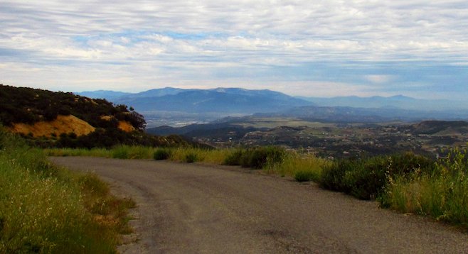
One of many panoramas from the Cleveland National Forest's South Main Divide.
Escaping the crowds and congested highways of coastal southern California, road warriors take to the hills. SoCal boasts some of the most beautiful scenic highways in the country, some right outside the largest metro areas.
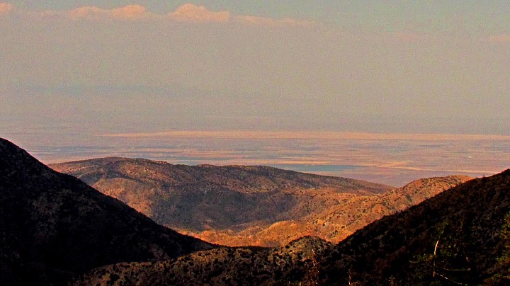
Angeles Crest: looking north towards the Mojave from the 7,901-foot Dawson Saddle.
Weekend excursionists with an itch to shoulder deep bends and the stomach for blind drops will enjoy the ride on “pleasure parkways” such the 33-mile Oretga Highway, 66-mile Angeles Crest Scenic Byway, 101-mile Rim of the World Highway and 67-mile Pines to Palms Scenic Byway.
Although the killer S-turns through the miles of undeveloped, forested mountains and panoramic vistas makes these byways popular recreational – if not leisurely – weekend drives, “killer,” unfortunately, is the operative word. Driver recklessness and high speeds, particularly from motorcyclists, contribute to high death tolls. For this reason, extreme caution and attentive driving is strongly advised.
Ortega Highway
While tourists head west for their Golden State holiday, non-surfing SoCal locals head east into the Cleveland National Forest, where 20 million residents living within a two-hour radius of the protected woodland have 460,000 acres to find refuge from the noise and bustle of urban existence.
Scenic Route 74 spans from Route 5 at San Juan Capistrano to Desert Palms slicing the northern section of the forest. Ortega Highway constitutes the 33-mile section of Route 74 between Route 5 and Route 15, from the ocean to Lake Elsinore. Built on former Indian trails, it cuts through both the Orange County Caspers Wilderness and the Cleveland National Forest as it climbs over the Santa Ana Mountains.
For the off-the-beaten-path experience, South Main Divide leads south from Ortega Highway, straddling the rim of Mount Elsinore, weaving along Saddleback Ridge, plunging into canyons and snaking up Mount Santiago at 5,689 feet. It should be noted that this is not a main highway, but an extra-scenic diversion with views of Mount Jacinto, Lake Elsinore and Temecula Valley, as well as ocean views of Catalina Island. South Main Divide's not for the fainthearted; there are few turnabouts and many blind curves and sheer drops. It's a narrow, single-lane, barely paved former truck route. But those adventurous enough to dare it get access to a forgotten outback embedded in the quietude of Cleveland’s deeply trenched forest.
South Main Divide can be accessed from just outside the Santa Rosa Plateau Ecological Reserve north of Fallbrook and west of Temecula, entering through the Tenaja Falls area. Although it's only some 39 miles from Fallbrook to the Ortega Highway, it’ll take a few hours to transverse. Once on the 74, turn left to head through the forest towards San Capistrano or right towards Lake Elsinore.
Angeles Crest Scenic Byway
The Angeles Crest Scenic Byway runs east from La Cañada-Flintridge off I-210 along SR 2 ascending up into the Angeles National Forest, winding along the San Gabriel Mountains' highest and most scenic ridges.
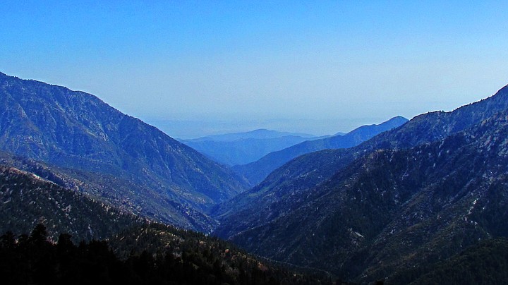
Angeles Crest Highway view on a hazy day.
Rising to an elevation of 7,901 feet at its highest point at Dawson Saddle, Angeles Crest Scenic Byway ends at Wrightwood at the junction of Route 138 with vista points providing expansive views (on a clear smog-free day) of the Los Angeles Basin, Pacific Ocean and Catalina Island, Pomona Valley, and Mojave Desert all along the way.
Wilson Mountain Observatory, which is open to the public on weekends, and the Pacific Crest National Scenic Trail, which crossed 60 major mountain passes and has the greatest elevation changes of any of America's National Scenic Trails including the Continental Divide Trail, are both accessible from the byway.
Rim of the World Scenic Byway
The Rim of the World Highway offers panoramic views along the crest of the San Bernardino Mountain range along SR-18. Picking up Route 138 at Mormon Rocks, just east of I-15 or SR-330 out of San Bernardino, the Rim of the World Highway retraces parts of the historic Mormon, Old Spanish and Santa Fe trails. Reaching elevations just shy of 7,000 feet, the highway cuts through the Bernardino National Forest, passing giant sequoias, numerous lakes and wildflower-speckled meadows galore.
Rim of the World, formerly called High Gear Road, can be as treacherous as it is scenic due to steep switchbacks with sheer drops on both sides of the highway. The clouds that regularly engulf the mountain tops, making them appear to be islands in the sky, can also be a distraction.
Whether you're there to see the autumn foliage, snow-capped summits or spring time dogwood groves in bloom, there are many pullouts and vista points to safely take in the views.
The National Children’s Forest with its trees named after and trails cut by children, maintains the most popular hiking/snowshoeing/Nordic skiing trail in the San Bernardino National Forest. The Exploration Trail cuts through stands of sugar pines, the world’s tallest pines.
At Big Bear, you can choose to head north to Lucerne Valley, where the Piute, Chemehuevi and Serrano tribes made their last pitch effort to retain their ancestral homeland before massacred and pushed into the Mojave. If you do so, turn west onto Route 247 back towards the I-15. Otherwise, continue south towards the Banning Pass.
Palms to Pines Scenic Byway
The Palms to Pines Scenic Byway is the poetic name given to the beautiful stretch of twisting road between the Banning Pass, Route 243 to Idyllwild, and Desert Palms, via Route 74.
If you are driving these byways back-to-back, it's 377 miles total between Fallbrook and Idyllwild. Depending on your time and inclination, you may want to pick up Route 111 south out of Desert Palms and skirt the serene Salton Sea, swinging west at the 10 or follow 371 off the 74 to Route 79 back towards San Diego.
Here's something you might be interested in.
SoCal Five-Gear Weekend Excursions
SoCal Five-Gear Weekend Excursions
One of many panoramas from the Cleveland National Forest's South Main Divide.
Escaping the crowds and congested highways of coastal southern California, road warriors take to the hills. SoCal boasts some of the most beautiful scenic highways in the country, some right outside the largest metro areas.
Angeles Crest: looking north towards the Mojave from the 7,901-foot Dawson Saddle.
Weekend excursionists with an itch to shoulder deep bends and the stomach for blind drops will enjoy the ride on “pleasure parkways” such the 33-mile Oretga Highway, 66-mile Angeles Crest Scenic Byway, 101-mile Rim of the World Highway and 67-mile Pines to Palms Scenic Byway.
Although the killer S-turns through the miles of undeveloped, forested mountains and panoramic vistas makes these byways popular recreational – if not leisurely – weekend drives, “killer,” unfortunately, is the operative word. Driver recklessness and high speeds, particularly from motorcyclists, contribute to high death tolls. For this reason, extreme caution and attentive driving is strongly advised.
Ortega Highway
While tourists head west for their Golden State holiday, non-surfing SoCal locals head east into the Cleveland National Forest, where 20 million residents living within a two-hour radius of the protected woodland have 460,000 acres to find refuge from the noise and bustle of urban existence.
Scenic Route 74 spans from Route 5 at San Juan Capistrano to Desert Palms slicing the northern section of the forest. Ortega Highway constitutes the 33-mile section of Route 74 between Route 5 and Route 15, from the ocean to Lake Elsinore. Built on former Indian trails, it cuts through both the Orange County Caspers Wilderness and the Cleveland National Forest as it climbs over the Santa Ana Mountains.
For the off-the-beaten-path experience, South Main Divide leads south from Ortega Highway, straddling the rim of Mount Elsinore, weaving along Saddleback Ridge, plunging into canyons and snaking up Mount Santiago at 5,689 feet. It should be noted that this is not a main highway, but an extra-scenic diversion with views of Mount Jacinto, Lake Elsinore and Temecula Valley, as well as ocean views of Catalina Island. South Main Divide's not for the fainthearted; there are few turnabouts and many blind curves and sheer drops. It's a narrow, single-lane, barely paved former truck route. But those adventurous enough to dare it get access to a forgotten outback embedded in the quietude of Cleveland’s deeply trenched forest.
South Main Divide can be accessed from just outside the Santa Rosa Plateau Ecological Reserve north of Fallbrook and west of Temecula, entering through the Tenaja Falls area. Although it's only some 39 miles from Fallbrook to the Ortega Highway, it’ll take a few hours to transverse. Once on the 74, turn left to head through the forest towards San Capistrano or right towards Lake Elsinore.
Angeles Crest Scenic Byway
The Angeles Crest Scenic Byway runs east from La Cañada-Flintridge off I-210 along SR 2 ascending up into the Angeles National Forest, winding along the San Gabriel Mountains' highest and most scenic ridges.
Angeles Crest Highway view on a hazy day.
Rising to an elevation of 7,901 feet at its highest point at Dawson Saddle, Angeles Crest Scenic Byway ends at Wrightwood at the junction of Route 138 with vista points providing expansive views (on a clear smog-free day) of the Los Angeles Basin, Pacific Ocean and Catalina Island, Pomona Valley, and Mojave Desert all along the way.
Wilson Mountain Observatory, which is open to the public on weekends, and the Pacific Crest National Scenic Trail, which crossed 60 major mountain passes and has the greatest elevation changes of any of America's National Scenic Trails including the Continental Divide Trail, are both accessible from the byway.
Rim of the World Scenic Byway
The Rim of the World Highway offers panoramic views along the crest of the San Bernardino Mountain range along SR-18. Picking up Route 138 at Mormon Rocks, just east of I-15 or SR-330 out of San Bernardino, the Rim of the World Highway retraces parts of the historic Mormon, Old Spanish and Santa Fe trails. Reaching elevations just shy of 7,000 feet, the highway cuts through the Bernardino National Forest, passing giant sequoias, numerous lakes and wildflower-speckled meadows galore.
Rim of the World, formerly called High Gear Road, can be as treacherous as it is scenic due to steep switchbacks with sheer drops on both sides of the highway. The clouds that regularly engulf the mountain tops, making them appear to be islands in the sky, can also be a distraction.
Whether you're there to see the autumn foliage, snow-capped summits or spring time dogwood groves in bloom, there are many pullouts and vista points to safely take in the views.
The National Children’s Forest with its trees named after and trails cut by children, maintains the most popular hiking/snowshoeing/Nordic skiing trail in the San Bernardino National Forest. The Exploration Trail cuts through stands of sugar pines, the world’s tallest pines.
At Big Bear, you can choose to head north to Lucerne Valley, where the Piute, Chemehuevi and Serrano tribes made their last pitch effort to retain their ancestral homeland before massacred and pushed into the Mojave. If you do so, turn west onto Route 247 back towards the I-15. Otherwise, continue south towards the Banning Pass.
Palms to Pines Scenic Byway
The Palms to Pines Scenic Byway is the poetic name given to the beautiful stretch of twisting road between the Banning Pass, Route 243 to Idyllwild, and Desert Palms, via Route 74.
If you are driving these byways back-to-back, it's 377 miles total between Fallbrook and Idyllwild. Depending on your time and inclination, you may want to pick up Route 111 south out of Desert Palms and skirt the serene Salton Sea, swinging west at the 10 or follow 371 off the 74 to Route 79 back towards San Diego.
Comments