Here's something you might be interested in.
Ask a Hipster — Advice you didn't know you needed
Big Screen — Movie commentary
Blurt — Music's inside track
Booze News — San Diego spirits
Classical Music — Immortal beauty
Classifieds — Free and easy
Cover Stories — Front-page features
Drinks All Around — Bartenders' drink recipes
Excerpts — Literary and spiritual excerpts
Feast! — Food & drink reviews
Feature Stories — Local news & stories
Fishing Report — What’s getting hooked from ship and shore
From the Archives — Spotlight on the past
Golden Dreams — Talk of the town
The Gonzo Report — Making the musical scene, or at least reporting from it
Letters — Our inbox
Movies@Home — Local movie buffs share favorites
Movie Reviews — Our critics' picks and pans
Musician Interviews — Up close with local artists
Neighborhood News from Stringers — Hyperlocal news
News Ticker — News & politics
Obermeyer — San Diego politics illustrated
Outdoors — Weekly changes in flora and fauna
Overheard in San Diego — Eavesdropping illustrated
Poetry — The old and the new
Reader Travel — Travel section built by travelers
Reading — The hunt for intellectuals
Roam-O-Rama — SoCal's best hiking/biking trails
San Diego Beer — Inside San Diego suds
SD on the QT — Almost factual news
Sheep and Goats — Places of worship
Special Issues — The best of
Street Style — San Diego streets have style
Surf Diego — Real stories from those braving the waves
Theater — On stage in San Diego this week
Tin Fork — Silver spoon alternative
Under the Radar — Matt Potter's undercover work
Unforgettable — Long-ago San Diego
Unreal Estate — San Diego's priciest pads
Your Week — Daily event picks
Twin Peaks
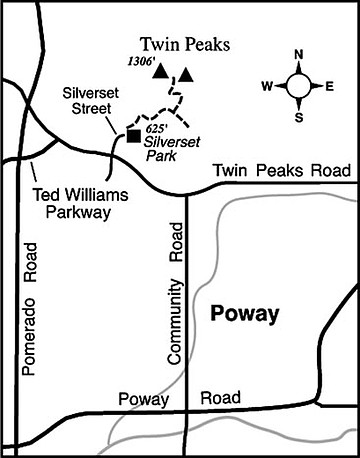
Twin Peaks, a scruffy, boulder-studded promontory rising amid Poway’s suburban streets, is less known for its own existence than for the major street named after it: Twin Peaks Road. After a short but vigorous climb, it’s fun to poke in and around the fractured outcrops of rock and stand on the breezy summit to admire the inclusive view of Poway and its environs. The two-mile round-trip to the top involves a short, very steep segment of hard-packed dirt road, plus another very steep section of narrow trail strewn with jagged rocks, so make sure your shoes have good ankle support and traction. This could be quite an adventure for little ones, as long as they are properly supervised and possibly given an assist at a couple of spots. For summertime comfort, you’d best make this climb in the cool morning or early evening hours. And don’t forget to take along drinking water.
To get to the starting point for the Twin Peaks hike, exit Interstate 15 at Ted Williams Parkway and drive east 2.5 miles to Twin Peaks Road. Turn right (east), proceed 0.4 mile, and turn left on Silverset Street. Drive north to the end of the street and arrive at Silverset Park, where you can leave your car either in a small lot or in the surrounding neighborhood.
From Silverset Park, you face a climb of 700 vertical feet. Start off by following a fire road going northeast to the brow of a south-trending ridge. Just as this road starts to flatten and descend, veer left on a narrow path going left (north) up along the ridge. After 0.2 mile the path bends left and makes a brief descent through thick chaparral into the bottom of a ravine. Once you’re in that ravine, turn sharply uphill and climb straight to the saddle between the two peaks. The peak to the left, about 60 feet higher than the one on the right, has the better view by far.
As seen from the summit, a carpet of tract-style homes recedes in the south, while mansions on generous lots fill the hills and valleys to the north and east. A small blue slice of Lake Poway lies some three miles to the northeast, while the more conspicuous rock-fill dam of Ramona Reservoir nuzzles into rocky hills beyond. Look for the distinctive “Tooth Rock” in the east, atop a ridge in the middle distance.
This article contains information about a publicly owned recreation or wilderness area. Trails and pathways are not necessarily marked. Conditions can change rapidly. Hikers should be properly equipped and have safety and navigational skills. The Reader and Jerry Schad assume no responsibility for any adverse experience.
TWIN PEAKS
Enjoy an all-around view from the top of Poway’s Twin Peaks summit.
Distance from downtown San Diego: 26 miles
Hiking length: 2 miles round-trip
Difficulty: Moderate
Here's something you might be interested in.
Twin Peaks
Twin Peaks
Twin Peaks, a scruffy, boulder-studded promontory rising amid Poway’s suburban streets, is less known for its own existence than for the major street named after it: Twin Peaks Road. After a short but vigorous climb, it’s fun to poke in and around the fractured outcrops of rock and stand on the breezy summit to admire the inclusive view of Poway and its environs. The two-mile round-trip to the top involves a short, very steep segment of hard-packed dirt road, plus another very steep section of narrow trail strewn with jagged rocks, so make sure your shoes have good ankle support and traction. This could be quite an adventure for little ones, as long as they are properly supervised and possibly given an assist at a couple of spots. For summertime comfort, you’d best make this climb in the cool morning or early evening hours. And don’t forget to take along drinking water.
To get to the starting point for the Twin Peaks hike, exit Interstate 15 at Ted Williams Parkway and drive east 2.5 miles to Twin Peaks Road. Turn right (east), proceed 0.4 mile, and turn left on Silverset Street. Drive north to the end of the street and arrive at Silverset Park, where you can leave your car either in a small lot or in the surrounding neighborhood.
From Silverset Park, you face a climb of 700 vertical feet. Start off by following a fire road going northeast to the brow of a south-trending ridge. Just as this road starts to flatten and descend, veer left on a narrow path going left (north) up along the ridge. After 0.2 mile the path bends left and makes a brief descent through thick chaparral into the bottom of a ravine. Once you’re in that ravine, turn sharply uphill and climb straight to the saddle between the two peaks. The peak to the left, about 60 feet higher than the one on the right, has the better view by far.
As seen from the summit, a carpet of tract-style homes recedes in the south, while mansions on generous lots fill the hills and valleys to the north and east. A small blue slice of Lake Poway lies some three miles to the northeast, while the more conspicuous rock-fill dam of Ramona Reservoir nuzzles into rocky hills beyond. Look for the distinctive “Tooth Rock” in the east, atop a ridge in the middle distance.
This article contains information about a publicly owned recreation or wilderness area. Trails and pathways are not necessarily marked. Conditions can change rapidly. Hikers should be properly equipped and have safety and navigational skills. The Reader and Jerry Schad assume no responsibility for any adverse experience.
TWIN PEAKS
Enjoy an all-around view from the top of Poway’s Twin Peaks summit.
Distance from downtown San Diego: 26 miles
Hiking length: 2 miles round-trip
Difficulty: Moderate