Here's something you might be interested in.
Ask a Hipster — Advice you didn't know you needed
Big Screen — Movie commentary
Blurt — Music's inside track
Booze News — San Diego spirits
Classical Music — Immortal beauty
Classifieds — Free and easy
Cover Stories — Front-page features
Drinks All Around — Bartenders' drink recipes
Excerpts — Literary and spiritual excerpts
Feast! — Food & drink reviews
Feature Stories — Local news & stories
Fishing Report — What’s getting hooked from ship and shore
From the Archives — Spotlight on the past
Golden Dreams — Talk of the town
The Gonzo Report — Making the musical scene, or at least reporting from it
Letters — Our inbox
Movies@Home — Local movie buffs share favorites
Movie Reviews — Our critics' picks and pans
Musician Interviews — Up close with local artists
Neighborhood News from Stringers — Hyperlocal news
News Ticker — News & politics
Obermeyer — San Diego politics illustrated
Outdoors — Weekly changes in flora and fauna
Overheard in San Diego — Eavesdropping illustrated
Poetry — The old and the new
Reader Travel — Travel section built by travelers
Reading — The hunt for intellectuals
Roam-O-Rama — SoCal's best hiking/biking trails
San Diego Beer — Inside San Diego suds
SD on the QT — Almost factual news
Sheep and Goats — Places of worship
Special Issues — The best of
Street Style — San Diego streets have style
Surf Diego — Real stories from those braving the waves
Theater — On stage in San Diego this week
Tin Fork — Silver spoon alternative
Under the Radar — Matt Potter's undercover work
Unforgettable — Long-ago San Diego
Unreal Estate — San Diego's priciest pads
Your Week — Daily event picks
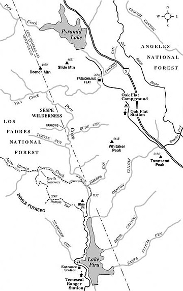
Remote Piru Creek, in the Los Padres National Forest north of Los Angeles, offers a challenging wilderness experience.
Although relatively unknown among hikers, the Piru Creek gorge offers a rugged wilderness experience less than one hour's drive away from L.A.'s northern suburbs. In 1992 the 220,000-acre Sespe Wilderness was carved out of lands lying mostly west of Piru Creek. This spacious wilderness area includes the Sespe Condor Sanctuary (closed to all recreational use), where California condors raised in captive breeding programs have been released into the wild.
Experienced hikers/backpackers can mount a two-day expedition down along Piru Creek, which involves almost no true climbing but rather many miles of riverbank walking and foot-wetting creek crossings. The area was blackened by the October 2007 Ranch Fire, so it is imperative that you contact Los Padres National Forest (805-646-4348) for the latest information about whether the Piru Creek route is accessible and legally open to foot travel. Also, check on river conditions, wilderness area rules, and logistics. If the water in the creek is flowing too fast, you will want to postpone your trip.
To reach the starting point from Interstate 5, take the Templin Highway exit and drive up the west-side frontage road (old Highway 99) to a point two miles past Oak Flat Campground's entrance. There you'll find Frenchman's Flat (elevation 2050 feet) -- a large, dirt lot on the left. Fishers by the score park here and then hike down the Piru Creek canyon in search of trout-fishing holes. The stream is artificially stocked.
From Frenchman's Flat, work your way down the cottonwood- and willow-fringed banks, crossing whenever necessary. The stream slips over water-worn boulders, some the size of cars, and collects in silt-bottomed pools. You should resign yourself right away to walking in squishy boots. Once you get used to it, the interludes of wading will feel refreshing.
The seamed and shattered walls down the length of the gorge ahead, up to 500 feet high, disclose at least five distinct changes in the bedrock as you travel downstream. These rocks reflect a variety of ages, from older than 600 million years (Precambrian metamorphic rocks) to tens of millions of years old (Eocene sedimentary rocks). Several faults cross the route, including the northernmost end of the San Gabriel Fault. If you care to keep apprised of your progress down the canyon, be sure to keep updating your position on a topographic map. The Fish Creek confluence at 5.2 miles into the hike is a major milestone; there you change your general direction of travel from west to south.
The most interesting part of the canyon is an otherworldly passage just north of the confluence of Ruby Canyon (9.5 to 10 miles). There you make your way between grotesquely sculpted conglomerate-rock walls, wading most of the time.
South of the narrows the canyon widens considerably and you sometimes have the luxury of walking on flat, sandy terraces on either side of the creek. At around 11.5 miles, you can follow a remnant of an old trail on the canyon's west side for some distance before being forced back into the rocky bed of the creek. At 13.2 miles, you pick up an old road that will take you to a former parking and picnic area opposite the defunct Blue Point Campground (elevation 1130 feet), some 15 miles from Frenchman's Flat. You're now six miles away by paved road, often closed to vehicle traffic, from where you can reliably reach a parked automobile: the entrance to Lake Piru. Perhaps you have planted a second car there earlier, or someone can meet you at that finish point.
This article contains information about a publicly owned recreation or wilderness area. Trails and pathways are not necessarily marked. Conditions can change rapidly. Hikers should be properly equipped and have safety and navigational skills. The Reader and Jerry Schad assume no responsibility for any adverse experience.
Here's something you might be interested in.
Remote Piru Creek, in the Los Padres National Forest north of Los Angeles, offers a challenging wilderness experience.
Remote Piru Creek, in the Los Padres National Forest north of Los Angeles, offers a challenging wilderness experience.
Although relatively unknown among hikers, the Piru Creek gorge offers a rugged wilderness experience less than one hour's drive away from L.A.'s northern suburbs. In 1992 the 220,000-acre Sespe Wilderness was carved out of lands lying mostly west of Piru Creek. This spacious wilderness area includes the Sespe Condor Sanctuary (closed to all recreational use), where California condors raised in captive breeding programs have been released into the wild.
Experienced hikers/backpackers can mount a two-day expedition down along Piru Creek, which involves almost no true climbing but rather many miles of riverbank walking and foot-wetting creek crossings. The area was blackened by the October 2007 Ranch Fire, so it is imperative that you contact Los Padres National Forest (805-646-4348) for the latest information about whether the Piru Creek route is accessible and legally open to foot travel. Also, check on river conditions, wilderness area rules, and logistics. If the water in the creek is flowing too fast, you will want to postpone your trip.
To reach the starting point from Interstate 5, take the Templin Highway exit and drive up the west-side frontage road (old Highway 99) to a point two miles past Oak Flat Campground's entrance. There you'll find Frenchman's Flat (elevation 2050 feet) -- a large, dirt lot on the left. Fishers by the score park here and then hike down the Piru Creek canyon in search of trout-fishing holes. The stream is artificially stocked.
From Frenchman's Flat, work your way down the cottonwood- and willow-fringed banks, crossing whenever necessary. The stream slips over water-worn boulders, some the size of cars, and collects in silt-bottomed pools. You should resign yourself right away to walking in squishy boots. Once you get used to it, the interludes of wading will feel refreshing.
The seamed and shattered walls down the length of the gorge ahead, up to 500 feet high, disclose at least five distinct changes in the bedrock as you travel downstream. These rocks reflect a variety of ages, from older than 600 million years (Precambrian metamorphic rocks) to tens of millions of years old (Eocene sedimentary rocks). Several faults cross the route, including the northernmost end of the San Gabriel Fault. If you care to keep apprised of your progress down the canyon, be sure to keep updating your position on a topographic map. The Fish Creek confluence at 5.2 miles into the hike is a major milestone; there you change your general direction of travel from west to south.
The most interesting part of the canyon is an otherworldly passage just north of the confluence of Ruby Canyon (9.5 to 10 miles). There you make your way between grotesquely sculpted conglomerate-rock walls, wading most of the time.
South of the narrows the canyon widens considerably and you sometimes have the luxury of walking on flat, sandy terraces on either side of the creek. At around 11.5 miles, you can follow a remnant of an old trail on the canyon's west side for some distance before being forced back into the rocky bed of the creek. At 13.2 miles, you pick up an old road that will take you to a former parking and picnic area opposite the defunct Blue Point Campground (elevation 1130 feet), some 15 miles from Frenchman's Flat. You're now six miles away by paved road, often closed to vehicle traffic, from where you can reliably reach a parked automobile: the entrance to Lake Piru. Perhaps you have planted a second car there earlier, or someone can meet you at that finish point.
This article contains information about a publicly owned recreation or wilderness area. Trails and pathways are not necessarily marked. Conditions can change rapidly. Hikers should be properly equipped and have safety and navigational skills. The Reader and Jerry Schad assume no responsibility for any adverse experience.