Here's something you might be interested in.
Ask a Hipster — Advice you didn't know you needed
Big Screen — Movie commentary
Blurt — Music's inside track
Booze News — San Diego spirits
Classical Music — Immortal beauty
Classifieds — Free and easy
Cover Stories — Front-page features
Drinks All Around — Bartenders' drink recipes
Excerpts — Literary and spiritual excerpts
Feast! — Food & drink reviews
Feature Stories — Local news & stories
Fishing Report — What’s getting hooked from ship and shore
From the Archives — Spotlight on the past
Golden Dreams — Talk of the town
The Gonzo Report — Making the musical scene, or at least reporting from it
Letters — Our inbox
Movies@Home — Local movie buffs share favorites
Movie Reviews — Our critics' picks and pans
Musician Interviews — Up close with local artists
Neighborhood News from Stringers — Hyperlocal news
News Ticker — News & politics
Obermeyer — San Diego politics illustrated
Outdoors — Weekly changes in flora and fauna
Overheard in San Diego — Eavesdropping illustrated
Poetry — The old and the new
Reader Travel — Travel section built by travelers
Reading — The hunt for intellectuals
Roam-O-Rama — SoCal's best hiking/biking trails
San Diego Beer — Inside San Diego suds
SD on the QT — Almost factual news
Sheep and Goats — Places of worship
Special Issues — The best of
Street Style — San Diego streets have style
Surf Diego — Real stories from those braving the waves
Theater — On stage in San Diego this week
Tin Fork — Silver spoon alternative
Under the Radar — Matt Potter's undercover work
Unforgettable — Long-ago San Diego
Unreal Estate — San Diego's priciest pads
Your Week — Daily event picks
Big skies and springtime zephyrs await you at the new Santa Ysabel Open Space Preserve near Julian.
As San Diego County's newest (2006) open-space park, the Santa Ysabel Open Space Preserve is already establishing a reputation as one of the county's finest parcels of unburned montane landscape. Actually, the Cedar Fire in 2003 did lick its way capriciously through the hills and valleys of the former Santa Ysabel Ranch, sparing most of its acreage. Since a large fraction of the forest near Julian and in nearby Cuyamaca Rancho State Park was thoroughly incinerated, perhaps to a point beyond repair, the remaining unburned areas around Julian -- this one in particular -- are even more rare and valuable than before. The seven-mile-long loop hike (mountain bikes and dogs are also allowed) described here covers the preserve's east end.
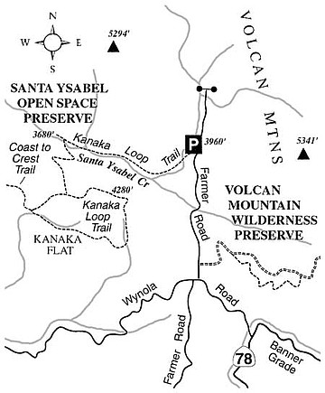
To get to the starting point from Julian, drive two miles north on Farmer Road to Wynola Road, jog briefly right, and turn left to remain on Farmer Road. Continue 1.2 miles north to the Santa Ysabel Open Space Preserve staging area on the left. Note that currently this trailhead, as well as the entire preserve, is open only on weekends.
Start heading west, alongside the upper reaches of Santa Ysabel Creek, on the Kanaka Loop Trail. This part of the trail doubles as a segment of the unfinished Coast to Crest Trail, which will ultimately stretch all the way to the coast at Del Mar.
Right away you'll notice cattle grazing on the grassy hillsides overlooking the creek. Grazing on the property is "grandfathered" in, at least for now. Another not-quite-natural occurrence is the appearance of large flocks of wild turkeys. The 20,000 or so turkeys now roaming the Julian-Cuyamaca area have descended from an initial population of about 300 that hunting enthusiasts introduced in 1993.
About one-half mile into the hike, there's an enchanting passage underneath the spreading limbs of massive live oak trees. Then, there's a mix of sun and shade as you continue down the valley. Wherever the trail sidles alongside the creek, you can admire the spreading forms of sycamore trees, and take note of blackberry thickets crowding the banks of the creek.
At 1.5 miles, just before a gate on the road ahead, you make a left turn, cross the creek, and start a steep ascent up a chaparral slope dotted with black oaks. Topping out, you discover spacious Kanaka Flat -- more of a gently rolling meadow than a true flat -- and probably more cattle. At the next junction, 2.2 miles, go left to encircle the rim of Kanaka Flat in the clockwise direction, or go right to make a counterclockwise loop. Either way, it's 2.6 miles around, and you return to this same junction.
On the eastern margins of Kanaka Flat, a few rural houses are in view, but toward the western side, hardly a single sign of civilization is visible anywhere save for the double-tracked "road" you are walking on. Kanaka Flat is reminiscent of Montana's big-sky country, especially when high-flying cirrus clouds paint the firmament. Some skeletal Coulter pines, victims of the Cedar Fire, plus a few surviving pines, dot the scene. When springtime zephyrs send waves through the supple green blades of grass, these trees link the solid earth to the stillness of the sky.
Here's something you might be interested in.
Big skies and springtime zephyrs await you at the new Santa Ysabel Open Space Preserve near Julian.
Big skies and springtime zephyrs await you at the new Santa Ysabel Open Space Preserve near Julian.
As San Diego County's newest (2006) open-space park, the Santa Ysabel Open Space Preserve is already establishing a reputation as one of the county's finest parcels of unburned montane landscape. Actually, the Cedar Fire in 2003 did lick its way capriciously through the hills and valleys of the former Santa Ysabel Ranch, sparing most of its acreage. Since a large fraction of the forest near Julian and in nearby Cuyamaca Rancho State Park was thoroughly incinerated, perhaps to a point beyond repair, the remaining unburned areas around Julian -- this one in particular -- are even more rare and valuable than before. The seven-mile-long loop hike (mountain bikes and dogs are also allowed) described here covers the preserve's east end.
To get to the starting point from Julian, drive two miles north on Farmer Road to Wynola Road, jog briefly right, and turn left to remain on Farmer Road. Continue 1.2 miles north to the Santa Ysabel Open Space Preserve staging area on the left. Note that currently this trailhead, as well as the entire preserve, is open only on weekends.
Start heading west, alongside the upper reaches of Santa Ysabel Creek, on the Kanaka Loop Trail. This part of the trail doubles as a segment of the unfinished Coast to Crest Trail, which will ultimately stretch all the way to the coast at Del Mar.
Right away you'll notice cattle grazing on the grassy hillsides overlooking the creek. Grazing on the property is "grandfathered" in, at least for now. Another not-quite-natural occurrence is the appearance of large flocks of wild turkeys. The 20,000 or so turkeys now roaming the Julian-Cuyamaca area have descended from an initial population of about 300 that hunting enthusiasts introduced in 1993.
About one-half mile into the hike, there's an enchanting passage underneath the spreading limbs of massive live oak trees. Then, there's a mix of sun and shade as you continue down the valley. Wherever the trail sidles alongside the creek, you can admire the spreading forms of sycamore trees, and take note of blackberry thickets crowding the banks of the creek.
At 1.5 miles, just before a gate on the road ahead, you make a left turn, cross the creek, and start a steep ascent up a chaparral slope dotted with black oaks. Topping out, you discover spacious Kanaka Flat -- more of a gently rolling meadow than a true flat -- and probably more cattle. At the next junction, 2.2 miles, go left to encircle the rim of Kanaka Flat in the clockwise direction, or go right to make a counterclockwise loop. Either way, it's 2.6 miles around, and you return to this same junction.
On the eastern margins of Kanaka Flat, a few rural houses are in view, but toward the western side, hardly a single sign of civilization is visible anywhere save for the double-tracked "road" you are walking on. Kanaka Flat is reminiscent of Montana's big-sky country, especially when high-flying cirrus clouds paint the firmament. Some skeletal Coulter pines, victims of the Cedar Fire, plus a few surviving pines, dot the scene. When springtime zephyrs send waves through the supple green blades of grass, these trees link the solid earth to the stillness of the sky.