Here's something you might be interested in.
Ask a Hipster — Advice you didn't know you needed
Big Screen — Movie commentary
Blurt — Music's inside track
Booze News — San Diego spirits
Classical Music — Immortal beauty
Classifieds — Free and easy
Cover Stories — Front-page features
Drinks All Around — Bartenders' drink recipes
Excerpts — Literary and spiritual excerpts
Feast! — Food & drink reviews
Feature Stories — Local news & stories
Fishing Report — What’s getting hooked from ship and shore
From the Archives — Spotlight on the past
Golden Dreams — Talk of the town
The Gonzo Report — Making the musical scene, or at least reporting from it
Letters — Our inbox
Movies@Home — Local movie buffs share favorites
Movie Reviews — Our critics' picks and pans
Musician Interviews — Up close with local artists
Neighborhood News from Stringers — Hyperlocal news
News Ticker — News & politics
Obermeyer — San Diego politics illustrated
Outdoors — Weekly changes in flora and fauna
Overheard in San Diego — Eavesdropping illustrated
Poetry — The old and the new
Reader Travel — Travel section built by travelers
Reading — The hunt for intellectuals
Roam-O-Rama — SoCal's best hiking/biking trails
San Diego Beer — Inside San Diego suds
SD on the QT — Almost factual news
Sheep and Goats — Places of worship
Special Issues — The best of
Street Style — San Diego streets have style
Surf Diego — Real stories from those braving the waves
Theater — On stage in San Diego this week
Tin Fork — Silver spoon alternative
Under the Radar — Matt Potter's undercover work
Unforgettable — Long-ago San Diego
Unreal Estate — San Diego's priciest pads
Your Week — Daily event picks
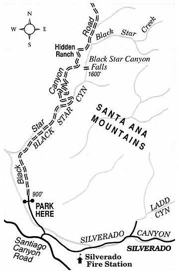
Orange County's Black Star Canyon conceals a surprising waterfall.
Good timing is the key to catching the waterfall in Black Star Canyon at its best. Since only about three square miles of drainage area lie above it, persistent rains are needed to get more than a dribble of water over the cliff. Experienced hikers might take five or more hours for the round-trip visit, which involves 800 feet of elevation gain and loss, and some pretty intense boulder hopping in the stream bed of Black Star Canyon. For confident navigation, the USGS topographic map quadrangle titled "Black Star Canyon" is helpful.
To reach the trailhead from the Eastern Transportation Corridor toll roads (either Highway 241 or 261) in eastern Orange County, exit at Santiago Canyon Road and drive east six miles to Silverado Canyon Road on the left. Proceed 0.1 mile toward Silverado Canyon, then turn left (north) on Black Star Canyon Road. After 1.1 miles, a sturdy gate, normally closed and locked, blocks further unauthorized vehicle traffic. Park here (no National Forest Adventure Pass is needed), and begin hiking. Orange County retains the right of way through both private and public lands ahead; simply stay on the road when traversing lands not included under National Forest jurisdiction.
After an uninteresting half mile along the dry, open bed of Santiago Creek, the road abruptly turns east into Black Star Canyon. Scattered oaks, sycamores, and willows, and rows of planted eucalyptus trees provide shade as the road meanders gently uphill along the creekbed. The canyon was named after the nearby Black Star Coal Mine, which was worked briefly more than a century ago during a silver- and coal-mining boom in the Silverado Canyon area. Look for seams of poor-quality coal in the roadcuts you pass.
At 2.5 miles the road doubles back in a hairpin turn and begins to ascend the sage-covered slopes to the north. You've now reached the corner of Section 30, which is part of Cleveland National Forest. It's time to put on long pants and a long-sleeved shirt to do battle with poison oak and other shrubbery as you leave the road and work your way up the canyon bottom. At least one strenuous hour (0.8 mile) of boulder-hopping, bushwhacking, and moderate hands-and-feet scrambling up the trenchlike confines of the canyon will take you to the base of the falls.
Marine sedimentary rocks are in evidence here. Bold outcrops of stratified, buff-colored siltstone rise hundreds of feet above the canyon bottom, giving safe quarter to nesting raptors and other birds. The creek slides around great blocks of conglomerate rock and pools up in shady grottos concealed amid large oak, alder, sycamore, and bay trees.
The semicircular siltstone headwall that forms the falls fairly drips with mosses and maidenhair ferns, if not always much water. When the flow is great enough, water cascades 50 feet down a polished chute, and also exits through an old mine shaft cut into the headwall about 15 feet above the falls' base.
When it's time to go, return to Black Star Canyon Road by the same route, making your way down the creekbed over now-familiar obstacles.
This article contains information about a publicly owned recreation or wilderness area. Trails and pathways are not necessarily marked. Conditions can change rapidly. Hikers should be properly equipped and have safety and navigational skills. The Reader and Jerry Schad assume no responsibility for any detrimental experience.
Here's something you might be interested in.
Orange County's Black Star Canyon conceals a surprising waterfall.
Orange County's Black Star Canyon conceals a surprising waterfall.
Good timing is the key to catching the waterfall in Black Star Canyon at its best. Since only about three square miles of drainage area lie above it, persistent rains are needed to get more than a dribble of water over the cliff. Experienced hikers might take five or more hours for the round-trip visit, which involves 800 feet of elevation gain and loss, and some pretty intense boulder hopping in the stream bed of Black Star Canyon. For confident navigation, the USGS topographic map quadrangle titled "Black Star Canyon" is helpful.
To reach the trailhead from the Eastern Transportation Corridor toll roads (either Highway 241 or 261) in eastern Orange County, exit at Santiago Canyon Road and drive east six miles to Silverado Canyon Road on the left. Proceed 0.1 mile toward Silverado Canyon, then turn left (north) on Black Star Canyon Road. After 1.1 miles, a sturdy gate, normally closed and locked, blocks further unauthorized vehicle traffic. Park here (no National Forest Adventure Pass is needed), and begin hiking. Orange County retains the right of way through both private and public lands ahead; simply stay on the road when traversing lands not included under National Forest jurisdiction.
After an uninteresting half mile along the dry, open bed of Santiago Creek, the road abruptly turns east into Black Star Canyon. Scattered oaks, sycamores, and willows, and rows of planted eucalyptus trees provide shade as the road meanders gently uphill along the creekbed. The canyon was named after the nearby Black Star Coal Mine, which was worked briefly more than a century ago during a silver- and coal-mining boom in the Silverado Canyon area. Look for seams of poor-quality coal in the roadcuts you pass.
At 2.5 miles the road doubles back in a hairpin turn and begins to ascend the sage-covered slopes to the north. You've now reached the corner of Section 30, which is part of Cleveland National Forest. It's time to put on long pants and a long-sleeved shirt to do battle with poison oak and other shrubbery as you leave the road and work your way up the canyon bottom. At least one strenuous hour (0.8 mile) of boulder-hopping, bushwhacking, and moderate hands-and-feet scrambling up the trenchlike confines of the canyon will take you to the base of the falls.
Marine sedimentary rocks are in evidence here. Bold outcrops of stratified, buff-colored siltstone rise hundreds of feet above the canyon bottom, giving safe quarter to nesting raptors and other birds. The creek slides around great blocks of conglomerate rock and pools up in shady grottos concealed amid large oak, alder, sycamore, and bay trees.
The semicircular siltstone headwall that forms the falls fairly drips with mosses and maidenhair ferns, if not always much water. When the flow is great enough, water cascades 50 feet down a polished chute, and also exits through an old mine shaft cut into the headwall about 15 feet above the falls' base.
When it's time to go, return to Black Star Canyon Road by the same route, making your way down the creekbed over now-familiar obstacles.
This article contains information about a publicly owned recreation or wilderness area. Trails and pathways are not necessarily marked. Conditions can change rapidly. Hikers should be properly equipped and have safety and navigational skills. The Reader and Jerry Schad assume no responsibility for any detrimental experience.