Here's something you might be interested in.
Ask a Hipster — Advice you didn't know you needed
Big Screen — Movie commentary
Blurt — Music's inside track
Booze News — San Diego spirits
Classical Music — Immortal beauty
Classifieds — Free and easy
Cover Stories — Front-page features
Drinks All Around — Bartenders' drink recipes
Excerpts — Literary and spiritual excerpts
Feast! — Food & drink reviews
Feature Stories — Local news & stories
Fishing Report — What’s getting hooked from ship and shore
From the Archives — Spotlight on the past
Golden Dreams — Talk of the town
The Gonzo Report — Making the musical scene, or at least reporting from it
Letters — Our inbox
Movies@Home — Local movie buffs share favorites
Movie Reviews — Our critics' picks and pans
Musician Interviews — Up close with local artists
Neighborhood News from Stringers — Hyperlocal news
News Ticker — News & politics
Obermeyer — San Diego politics illustrated
Outdoors — Weekly changes in flora and fauna
Overheard in San Diego — Eavesdropping illustrated
Poetry — The old and the new
Reader Travel — Travel section built by travelers
Reading — The hunt for intellectuals
Roam-O-Rama — SoCal's best hiking/biking trails
San Diego Beer — Inside San Diego suds
SD on the QT — Almost factual news
Sheep and Goats — Places of worship
Special Issues — The best of
Street Style — San Diego streets have style
Surf Diego — Real stories from those braving the waves
Theater — On stage in San Diego this week
Tin Fork — Silver spoon alternative
Under the Radar — Matt Potter's undercover work
Unforgettable — Long-ago San Diego
Unreal Estate — San Diego's priciest pads
Your Week — Daily event picks
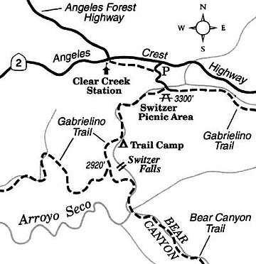
Discover a secretive, 50-foot waterfall in the rocky Arroyo Seco gorge above Pasadena.
The Spanish colonists who christened Arroyo Seco ("dry creek") evidently noted only its lower end -- a sweltering, boulder-strewn wash emptying into the Los Angeles River. It's hard to believe this same watercourse, draining the south slope of the San Gabriel Mountains some 20 miles upstream, assumes the character of a mountain brook, dancing over boulders and sliding down sheer inclines up to 50 feet in height.
If this season's torrential rains continue, that peaceful brook may be a bit too lively to explore safely for a certain period afterward -- not to mention the possibility of restricted access due to mountain highway damage and closures. For these reasons, it's a good idea to contact Angeles National Forest (626-574-1613 or www.fs.fed.us/r5/angeles/) before setting off on a trip anywhere in the San Gabriel Mountains.
Our route sampling the upper Arroyo Seco takes you by trail around the main, inaccessible falls and down to a lesser cascade in the canyon below. The starting point, the popular Switzer Picnic Area, is located off Angeles Crest Highway (State Highway 2), ten miles east of Interstate 210 at La Cañada. Be aware that by the time fair weather arrives, parking space at the picnic area will be scarce or nonexistent if you arrive after midmorning on a Saturday, Sunday, or holiday.
At the west end of the picnic area, find and follow the signed Gabrielino Trail. Make your way past outlying picnic tables and down along the alder-shaded stream. Soon, nothing but the clear-flowing stream and rustling leaves disturb the silence. Remnants of an old paved road are occasionally underfoot. In a couple of spots you ford the stream by boulder-hopping -- no problem except after heavy rain.
One mile down the canyon you come upon the foundation remnants of Switzer's Camp (now the site of a walk-in campground). Established in 1884, the camp became the San Gabriels' premier wilderness resort in the early 1900s, patronized by Hollywood celebrities as well as anyone who had the gumption to hike or ride a burro up the tortuous Arroyo Seco trail from Pasadena. The resort suffered a decline in business after the construction of Angeles Crest Highway in the 1930s and was finally razed in the late '50s.
Below Switzer's Camp the stream slides 50 feet over Switzer Falls -- but don't go that way. Instead, cross the stream and continue on the Gabrielino Trail as it edges along the canyon's right (west) wall. To the left are glimpses of the falls, a dark pit below them, and the crumbled foundation of a miniature stone chapel (a part of the old resort) that perched on a ledge above the falls. Continue 0.2 mile to a trail junction. Take the left fork (the trail to Bear Canyon) and descend to the canyon bottom. There's a severe, unfenced dropoff on the left on the way down, so watch your step.
Leave the trail there and walk along the stream bank, or rock hop through the stream itself, 0.2 mile up-canyon. You'll come upon a shallow pool, fed by a 15-foot-high cascade just below the main Switzer Falls. This is a peaceful and secluded spot for a trail-mix snack or lunch. Signs here warn against climbing farther up the canyon, and that is advice well taken.
Here's something you might be interested in.
Discover a secretive, 50-foot waterfall in the rocky Arroyo Seco gorge above Pasadena.
Discover a secretive, 50-foot waterfall in the rocky Arroyo Seco gorge above Pasadena.
The Spanish colonists who christened Arroyo Seco ("dry creek") evidently noted only its lower end -- a sweltering, boulder-strewn wash emptying into the Los Angeles River. It's hard to believe this same watercourse, draining the south slope of the San Gabriel Mountains some 20 miles upstream, assumes the character of a mountain brook, dancing over boulders and sliding down sheer inclines up to 50 feet in height.
If this season's torrential rains continue, that peaceful brook may be a bit too lively to explore safely for a certain period afterward -- not to mention the possibility of restricted access due to mountain highway damage and closures. For these reasons, it's a good idea to contact Angeles National Forest (626-574-1613 or www.fs.fed.us/r5/angeles/) before setting off on a trip anywhere in the San Gabriel Mountains.
Our route sampling the upper Arroyo Seco takes you by trail around the main, inaccessible falls and down to a lesser cascade in the canyon below. The starting point, the popular Switzer Picnic Area, is located off Angeles Crest Highway (State Highway 2), ten miles east of Interstate 210 at La Cañada. Be aware that by the time fair weather arrives, parking space at the picnic area will be scarce or nonexistent if you arrive after midmorning on a Saturday, Sunday, or holiday.
At the west end of the picnic area, find and follow the signed Gabrielino Trail. Make your way past outlying picnic tables and down along the alder-shaded stream. Soon, nothing but the clear-flowing stream and rustling leaves disturb the silence. Remnants of an old paved road are occasionally underfoot. In a couple of spots you ford the stream by boulder-hopping -- no problem except after heavy rain.
One mile down the canyon you come upon the foundation remnants of Switzer's Camp (now the site of a walk-in campground). Established in 1884, the camp became the San Gabriels' premier wilderness resort in the early 1900s, patronized by Hollywood celebrities as well as anyone who had the gumption to hike or ride a burro up the tortuous Arroyo Seco trail from Pasadena. The resort suffered a decline in business after the construction of Angeles Crest Highway in the 1930s and was finally razed in the late '50s.
Below Switzer's Camp the stream slides 50 feet over Switzer Falls -- but don't go that way. Instead, cross the stream and continue on the Gabrielino Trail as it edges along the canyon's right (west) wall. To the left are glimpses of the falls, a dark pit below them, and the crumbled foundation of a miniature stone chapel (a part of the old resort) that perched on a ledge above the falls. Continue 0.2 mile to a trail junction. Take the left fork (the trail to Bear Canyon) and descend to the canyon bottom. There's a severe, unfenced dropoff on the left on the way down, so watch your step.
Leave the trail there and walk along the stream bank, or rock hop through the stream itself, 0.2 mile up-canyon. You'll come upon a shallow pool, fed by a 15-foot-high cascade just below the main Switzer Falls. This is a peaceful and secluded spot for a trail-mix snack or lunch. Signs here warn against climbing farther up the canyon, and that is advice well taken.