Here's something you might be interested in.
Ask a Hipster — Advice you didn't know you needed
Big Screen — Movie commentary
Blurt — Music's inside track
Booze News — San Diego spirits
Classical Music — Immortal beauty
Classifieds — Free and easy
Cover Stories — Front-page features
Drinks All Around — Bartenders' drink recipes
Excerpts — Literary and spiritual excerpts
Feast! — Food & drink reviews
Feature Stories — Local news & stories
Fishing Report — What’s getting hooked from ship and shore
From the Archives — Spotlight on the past
Golden Dreams — Talk of the town
The Gonzo Report — Making the musical scene, or at least reporting from it
Letters — Our inbox
Movies@Home — Local movie buffs share favorites
Movie Reviews — Our critics' picks and pans
Musician Interviews — Up close with local artists
Neighborhood News from Stringers — Hyperlocal news
News Ticker — News & politics
Obermeyer — San Diego politics illustrated
Outdoors — Weekly changes in flora and fauna
Overheard in San Diego — Eavesdropping illustrated
Poetry — The old and the new
Reader Travel — Travel section built by travelers
Reading — The hunt for intellectuals
Roam-O-Rama — SoCal's best hiking/biking trails
San Diego Beer — Inside San Diego suds
SD on the QT — Almost factual news
Sheep and Goats — Places of worship
Special Issues — The best of
Street Style — San Diego streets have style
Surf Diego — Real stories from those braving the waves
Theater — On stage in San Diego this week
Tin Fork — Silver spoon alternative
Under the Radar — Matt Potter's undercover work
Unforgettable — Long-ago San Diego
Unreal Estate — San Diego's priciest pads
Your Week — Daily event picks
Climb the conical summit of Iron Mountain, which rises over the mists of North San Diego County.
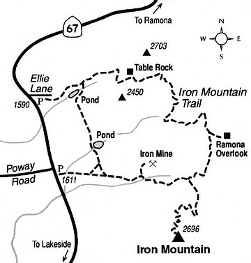
Poway's Iron Mountain thrusts its conical, chaparral-clad summit nearly 2700 feet above sea level, a height that is frequently well above the low-lying coastal haze. On many a crystalline winter day, the summit offers a sweeping, 360-degree panorama from glistening ocean to blue mountains and back to the ocean again. The main trail to the summit, 3.2 miles one way, is smoothly graded, hardly falters in its steady elevation gain, and is popular with all types of self-propelled travelers.
The starting point is just south of the intersection of Highway 67 and Poway Road, where parking is available along both sides of Highway 67. Construction will start soon on a trailhead parking lot designed to accommodate dozens of cars. Head east on the initially wide and almost level path. Ignore the trail branching left (north) and continue to a place -- about a mile into the hike or bike ride -- where the trail briefly dips to cross the bottom of a ravine. On the far side of the ravine you climb in earnest for a while, negotiating the steepest grade you'll encounter along the whole route.
At 1.5 miles you reach a saddle where you can turn left or right. Stay right and commence a generally leisurely (for a while) ascent through the waist- or shoulder-high chaparral. The vegetation is slowly recovering after a 1995 wildfire burned everything to ashes along the entire route. After a decided turn to the west, the ascent becomes steeper again, and final switchbacks take you back and forth across the ever-narrowing summit cone. On top you may find a visitor register -- a notebook stuffed with hundreds of written comments. You'll also find a massive, pier-mounted telescope (no coins required) thoughtfully placed so anyone can scan the near and far horizons.
When it's time to go, return the same way.
You may add three additional miles to your route -- plus some challenging up-and- down segments -- by returning to the Highway 67/Poway Road trailhead via a looping path to the north. You'll pass such minor landmarks as Table Rock and two cattle ponds. The mature chaparral vegetation (mixed with a few oaks) along this northern loop has been untouched by fire for several decades.
The Ellie Lane trailhead, a large equestrian staging area 0.7 mile north of Poway Road, offers an alternative starting point for the northern loop. It is typically underutilized and offers plenty of parking space.
Here's something you might be interested in.
Climb the conical summit of Iron Mountain, which rises over the mists of North San Diego County.
Climb the conical summit of Iron Mountain, which rises over the mists of North San Diego County.
Poway's Iron Mountain thrusts its conical, chaparral-clad summit nearly 2700 feet above sea level, a height that is frequently well above the low-lying coastal haze. On many a crystalline winter day, the summit offers a sweeping, 360-degree panorama from glistening ocean to blue mountains and back to the ocean again. The main trail to the summit, 3.2 miles one way, is smoothly graded, hardly falters in its steady elevation gain, and is popular with all types of self-propelled travelers.
The starting point is just south of the intersection of Highway 67 and Poway Road, where parking is available along both sides of Highway 67. Construction will start soon on a trailhead parking lot designed to accommodate dozens of cars. Head east on the initially wide and almost level path. Ignore the trail branching left (north) and continue to a place -- about a mile into the hike or bike ride -- where the trail briefly dips to cross the bottom of a ravine. On the far side of the ravine you climb in earnest for a while, negotiating the steepest grade you'll encounter along the whole route.
At 1.5 miles you reach a saddle where you can turn left or right. Stay right and commence a generally leisurely (for a while) ascent through the waist- or shoulder-high chaparral. The vegetation is slowly recovering after a 1995 wildfire burned everything to ashes along the entire route. After a decided turn to the west, the ascent becomes steeper again, and final switchbacks take you back and forth across the ever-narrowing summit cone. On top you may find a visitor register -- a notebook stuffed with hundreds of written comments. You'll also find a massive, pier-mounted telescope (no coins required) thoughtfully placed so anyone can scan the near and far horizons.
When it's time to go, return the same way.
You may add three additional miles to your route -- plus some challenging up-and- down segments -- by returning to the Highway 67/Poway Road trailhead via a looping path to the north. You'll pass such minor landmarks as Table Rock and two cattle ponds. The mature chaparral vegetation (mixed with a few oaks) along this northern loop has been untouched by fire for several decades.
The Ellie Lane trailhead, a large equestrian staging area 0.7 mile north of Poway Road, offers an alternative starting point for the northern loop. It is typically underutilized and offers plenty of parking space.