Here's something you might be interested in.
Ask a Hipster — Advice you didn't know you needed
Big Screen — Movie commentary
Blurt — Music's inside track
Booze News — San Diego spirits
Classical Music — Immortal beauty
Classifieds — Free and easy
Cover Stories — Front-page features
Drinks All Around — Bartenders' drink recipes
Excerpts — Literary and spiritual excerpts
Feast! — Food & drink reviews
Feature Stories — Local news & stories
Fishing Report — What’s getting hooked from ship and shore
From the Archives — Spotlight on the past
Golden Dreams — Talk of the town
The Gonzo Report — Making the musical scene, or at least reporting from it
Letters — Our inbox
Movies@Home — Local movie buffs share favorites
Movie Reviews — Our critics' picks and pans
Musician Interviews — Up close with local artists
Neighborhood News from Stringers — Hyperlocal news
News Ticker — News & politics
Obermeyer — San Diego politics illustrated
Outdoors — Weekly changes in flora and fauna
Overheard in San Diego — Eavesdropping illustrated
Poetry — The old and the new
Reader Travel — Travel section built by travelers
Reading — The hunt for intellectuals
Roam-O-Rama — SoCal's best hiking/biking trails
San Diego Beer — Inside San Diego suds
SD on the QT — Almost factual news
Sheep and Goats — Places of worship
Special Issues — The best of
Street Style — San Diego streets have style
Surf Diego — Real stories from those braving the waves
Theater — On stage in San Diego this week
Tin Fork — Silver spoon alternative
Under the Radar — Matt Potter's undercover work
Unforgettable — Long-ago San Diego
Unreal Estate — San Diego's priciest pads
Your Week — Daily event picks
Pedal your fat-tired steed over 20 miles of pavement and rutted dirt road in and beyond Ramona's Pamo Valley.
Spared from the threat of being inundated by a large reservoir, Pamo Valley awaits a possible destiny of becoming one of the county's premier nature preserves. A large parcel of Cleveland National Forest land surrounds the valley, as do properties earmarked for inclusion in the 55-mile-long San Dieguito River Park gradually materializing between Del Mar and Julian.
For a cursory look at Pamo Valley, you may drive in and out of it by way of a single accessway -- Pamo Road. Better yet, you can tour the valley and much more using a mountain bike on the 20-mile-long (1800-foot elevation gain) loop route described here. Take plenty of food and especially water; there are no facilities along the way. In this warm, dry time of year, it is essential to get an early start to beat the midday heat!
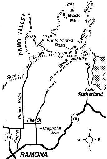
Start near the intersection of Magnolia Avenue and Highway 78, a mile east of Ramona. Head north on Magnolia, west on Pile Street, and north on Pamo Road. After reaching a crest on Pamo Road, a meteoric descent takes you into oak-fringed, sycamore-lined Pamo Valley, whose name is of Kumeyaay origin but unknown meaning.
At the bottom of the grade, you cross placid Santa Ysabel Creek on a narrow concrete bridge. Pavement ends, and you move on toward oak-dotted flats where cattle often graze. At 7.1 miles from the start, turn right on a dirt road (road 12S07, or Santa Ysabel Road) that is normally closed to motor-vehicle traffic. At the next junction, 8.6 miles into the ride, bear right to remain on Santa Ysabel Road. (The left branch leads 6 grueling miles to the 4051-foot summit of Black Mountain, a side trip for very motivated riders only.)
On a 3-mile stretch ahead, you contour across a steep slope overlooking oak- and sycamore-lined Santa Ysabel Creek -- which comes alive with cascading water during the rainy season. At 12.0 miles you cross the Black Canyon creekbed near the scant remains of the former Black Canyon Campground. Just uphill from there you meet the graded Black Canyon Road. Turn right, coast down to a narrow bridge -- your second crossing of Santa Ysabel Creek -- and stay right on the far side. All that's left now is another 7, mostly downhill miles on unpaved Black Canyon Road and paved Magnolia Avenue, leading back to the starting point.
Here's something you might be interested in.
Pedal your fat-tired steed over 20 miles of pavement and rutted dirt road in and beyond Ramona's Pamo Valley.
Pedal your fat-tired steed over 20 miles of pavement and rutted dirt road in and beyond Ramona's Pamo Valley.
Spared from the threat of being inundated by a large reservoir, Pamo Valley awaits a possible destiny of becoming one of the county's premier nature preserves. A large parcel of Cleveland National Forest land surrounds the valley, as do properties earmarked for inclusion in the 55-mile-long San Dieguito River Park gradually materializing between Del Mar and Julian.
For a cursory look at Pamo Valley, you may drive in and out of it by way of a single accessway -- Pamo Road. Better yet, you can tour the valley and much more using a mountain bike on the 20-mile-long (1800-foot elevation gain) loop route described here. Take plenty of food and especially water; there are no facilities along the way. In this warm, dry time of year, it is essential to get an early start to beat the midday heat!
Start near the intersection of Magnolia Avenue and Highway 78, a mile east of Ramona. Head north on Magnolia, west on Pile Street, and north on Pamo Road. After reaching a crest on Pamo Road, a meteoric descent takes you into oak-fringed, sycamore-lined Pamo Valley, whose name is of Kumeyaay origin but unknown meaning.
At the bottom of the grade, you cross placid Santa Ysabel Creek on a narrow concrete bridge. Pavement ends, and you move on toward oak-dotted flats where cattle often graze. At 7.1 miles from the start, turn right on a dirt road (road 12S07, or Santa Ysabel Road) that is normally closed to motor-vehicle traffic. At the next junction, 8.6 miles into the ride, bear right to remain on Santa Ysabel Road. (The left branch leads 6 grueling miles to the 4051-foot summit of Black Mountain, a side trip for very motivated riders only.)
On a 3-mile stretch ahead, you contour across a steep slope overlooking oak- and sycamore-lined Santa Ysabel Creek -- which comes alive with cascading water during the rainy season. At 12.0 miles you cross the Black Canyon creekbed near the scant remains of the former Black Canyon Campground. Just uphill from there you meet the graded Black Canyon Road. Turn right, coast down to a narrow bridge -- your second crossing of Santa Ysabel Creek -- and stay right on the far side. All that's left now is another 7, mostly downhill miles on unpaved Black Canyon Road and paved Magnolia Avenue, leading back to the starting point.